
| Institute of Geomechanics, Chinese Academy of Geological Sciences | Host |
| Citation: |
WANG Ran, MA Licheng, SUN Yong, ZHANG Shenglong, JIA Zhiming. A NEW GEOLOGICAL SECTION MEASURING AND MAPPING METHOD:POINT COORDINATES METHOD[J]. Journal of Geomechanics, 2017, 23(6): 856-863.

|
A NEW GEOLOGICAL SECTION MEASURING AND MAPPING METHOD:POINT COORDINATES METHOD
-
Abstract
Geological section measuring and mapping is a necessary task for regional geological survey; however, the traditional geological section measurement, which is based on tapeline together with compass, has many limitations such as visual conditions, tapeline bending, manual measurement error and second projection defects. In order to improve the quality and efficiency of geological section measurement, on the basis of the previous methods, through the practice of a number of different types of geological survey projects, a new geological section measuring and mapping method using point coordinates is presented in this paper. The key points of the method include (1) Using GPS to obtain terrain control points, as well as three-dimensional coordinates in stratification, sampling, production, occurrence and other positions. (2) A series of formulas are developed, based on which parameters like horizontal distance between points, altitude difference, azimuth angle and slope angle can be calculated according to three-dimensional space coordinates of each point in order to do the mapping. The point coordinates method has two main advantages:(1) Digitization of measurement data is realized by the change from manual measurement to automatic measurement, and there is no need for tape line. (2) The facts that the end point of the tapeline does not coincide with the actual end point can be avoided. (3) It is convenient for field review because each layering point has a GPS coordinate.The case and practice have proved that the point coordinates method is superior to the tapeline method. It is worthy of being widely used in practical application.
-
Keywords:
- cross section /
- tapeline method /
- point coordinates method /
- geological mapping
-

-
References
[1] 朱志澄.构造地质学[M].武汉:中国地质大学出版社, 1999. 262. ZHU Zhicheng. Structure Geology[M]. Wuhan:China University of Geosciences Press, 1999. 262. (in Chinese) [2] 辜平阳, 陈瑞明, 查显峰, 等.高山峡谷区1:50000地质填图技术方法探索与实践——以新疆乌什北山为例[J].地质力学学报, 2016, 22(4):837~855. GU Pingyang, CHEN Ruiming, CHA Xianfeng, et al. Exploration and practice of 1:50000 geological mapping techniques for alpine-gorge area:A case study in Beishan area uf Wushi, Xinjiang[J]. Journal of Geomechanics, 2016, 22(4):837~855. (in Chinese with English abstract) [3] 贾丽云, 叶培盛, 张绪教, 等.新构造填图方法探索、应用与实践——以内蒙古呼勒斯太苏木图幅1:5万填图试点为例[J].地质力学学报, 2017, 23(2):189~205. JIA Liyun, YE Peisheng, ZHANG Xujiao et al. Application and practice of the Neotectonics geological mapping methods——A case study of 1:50000 mapping pilot in Hulesitai, Inner Mongolia, China. Journal of Geomechanics, 2017, 23(2):189~205. (in Chinese with English abstract) [4] 杨星辰, 叶培盛, 蔡茂堂, 等.数字地质填图野外手图地理底图制作方法[J].地质力学学报, 2017, 23(3):333~338. YANG Xingchen, YE Peisheng, CAI Maotang et al. Methods for production of field free-hand maps and geographic basemaps in digital geological mapping[J]. Journal of Geomechanics, 2017, 23(3):333~338. (in Chinese with English abstract) [5] 周瑞华, 刘传正.野外地质工作实用手册[M].长沙:中南大学出版社, 2013. 223. ZHOU Ruihua, LIU Chuanzheng. Practical Manual of Field Geological Work[M]. Changsha:Central South University Press, 2013. 223. (in Chinese) [6] 王建芳, 包世泰, 余应刚, 等.基于GIS模板的地质剖面图模型及其实现[J].测绘科学, 2008, 33(5):184~186. WANG Jianfang, BAO Shitai, YU Ying-gang, et al. Realization of geological section map model based GIS template[J]. Science of Surveying and Mapping, 2008, 33(5):184~186. (in Chinese with English abstract) [7] 张京生, 董向勇.滑坡体地质剖面表达与绘制方法探讨[J].测绘通报, 2002, (9):62~64. ZHANG Jingsheng, DONG Xiangyong. A Study of Representation and Drawing of Geological Sections for Landslide Body[J]. Bulletin of Surveying and Mapping, 2002, (9):62~64. (in Chinese with English abstract) [8] 杨朝辉.基于IDL的三维地质剖面编绘系统的研制[J].测绘科学, 2009, 34(2):197~198, 186. YANG Zhaohui. Research on 3D drawing system for the cross section of a geological map based on IDL[J]. Science of Surveying and Mapping, 2009, 34(2):197~198, 186. (in Chinese with English abstract) [9] 唐春艳, 王玉兰, 彭继兵, 等.地质剖面图自动绘制方法[J].世界地质, 2004, 23(4):348~353. TANG Chunyan, WANG Yulian, PENG Jibing, et al. Method of automatic geological sectional drawing[J]. Global Geology, 2004, 23(4):348~353. (in Chinese with English abstract) [10] 张克信, 李超岭, 于庆文, 等.数字地质填图技术中的数字剖面系统[J].地层学杂志, 2007, 31(2):157~164. ZHANG Kexin, LI Chaoling, YU Qingwen, et al. The digital section system of digital mapping techniques[J]. Journal of Stratigraphy, 2007, 31(2):157~164. (in Chinese with English abstract) [11] 郭福生, 吴志春, 谢财富, 等.数字地质填图系统的几点改进意见及实用技巧[J].中国地质, 2012, 39(1):252~259. GUO Fusheng, WU Zhichun, XIE Caifu, et al. Some suggestions for the improvement of the regional geological mapping system and practical skills[J]. Geology in China, 2012, 39(1):252~259. (in Chinese with English abstract) [12] 吴志春, 郭福生, 刘林清, 等.数字填图系统中数字实测剖面的校正[J].桂林理工大学学报, 2012, 32(1):91~95. WU Zhichun, GUO Fusheng, LIU Linqing, et al. Digital geological section correction in regional geological mapping system[J]. Journal of Guilin University of Technology, 2012, 32(1):91~95. (in Chinese with English abstract) [13] 罗嵩.对地质剖面测量中所谓二次投影的质疑[J].西北地质, 1982, (3):61~62. LUO Song. The question of the so-called two projection in the geological profile measurement[J]. Northwest Geology, 1982, (3):61~62. (in Chinese) [14] 赵文婷, 胡道功.东昆仑地质填图中北斗卫星定位系统应用研究[J].地质力学学报, 2012, 18(3):254~263. ZHAO Wenting, HU Daogong. Application of Beidou satellite positioning system in geological mapping in East Kunlun[J]. Journal of Geomechanics, 2012, 18(3):254~263. (in Chinese with English abstract) [15] Lin J Y, Wang R, Xiao Z X, et al. Application of backpack Lidar to geological cross-section measurement[C]//Proceedings of SPIE 10605, LIDAR Imaging Detection and Target Recognition. Changchun:SPIE, 2017, 106050J. [16] 马洪超.激光雷达测量技术在地学中的若干应用[J].地球科学-中国地质大学学报, 2011, 36(2):347~354. MA Hongchao. Review on Applications of LiDAR mapping technology to geosciences[J]. Earth Science-Journal of China University of Geosciences, 2011, 36(2):347~354. (in Chinese with English abstract) -
Access History
Figures(5)
Tables(1)

Export File
Citation
WANG Ran, MA Licheng, SUN Yong, ZHANG Shenglong, JIA Zhiming. A NEW GEOLOGICAL SECTION MEASURING AND MAPPING METHOD:POINT COORDINATES METHOD[J]. Journal of Geomechanics, 2017, 23(6): 856-863.
Format
Content
 DownLoad:
-
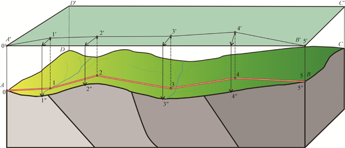
Figure 1.
The projection process model of the geological profile measured by the tapeline method
-
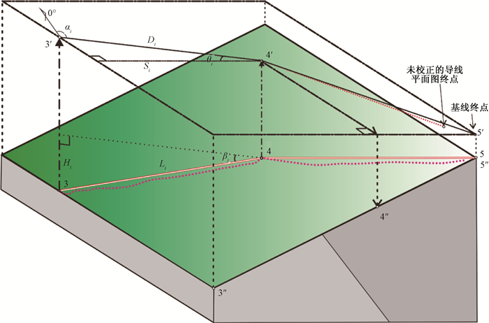
Figure 2.
Sketch map showing the trigonometric function of tapeline projection and its errors derived from tapeline bending
-
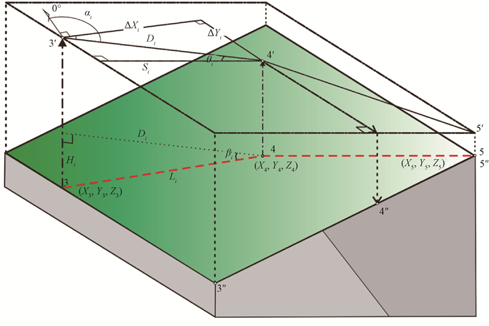
Figure 3.
Sketch map showing the trigonometric function of point coordinates projection
-
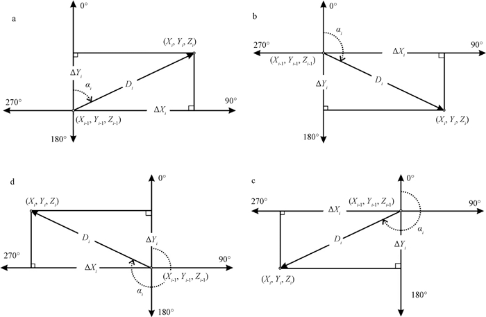
Figure 4.
Schematic diagram of trigonometric function of azimuth conversion by the point coordinates method
-
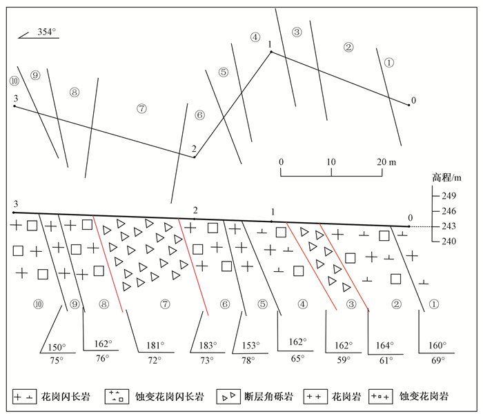
Figure 5.
The geological profile measurement by the point coordinates method in someplace, Fujian province