
| Citation: |
KANG Lei, LIU Shengrong, ZHANG Haidi, WANG Guocan, GUO Weili, LUO Yanjun, REN Guangli, LYU Pengrui, CAO Kai. 2023. Exploration of 1:50000 geological mapping in Gobi desert shallow covered area: a practice in Hami area of East Tianshan. Geological Bulletin of China, 42(4): 616-630. doi: 10.12097/j.issn.1671-2552.2023.04.010

|
Exploration of 1:50000 geological mapping in Gobi desert shallow covered area: a practice in Hami area of East Tianshan
-
Abstract
In order to better serve the construction of ecological civilization and high-quality economic and social development, geological mapping is urgently needed to be expanded from the bedrock area to covered area containing the basin-mountain combination zone and basin cover areas.Gobi desert shallow covered area is the key for investigating water, prospecting in hidden areas, and studying basin base properties, basin-mountain tectonic relationships and evolution in the midde-small cities and margin of metropotis of North China.However, there has been lack of systematic geological mapping techniques and methods for Gobi desert shallow covered area.In this paper, taking the Gobi desert shallow cover area in the joint part of Jueluotage Mountain and Turpan-Hami Basin in Hami area of East Tianshan Mountains as an example, using multiple technical methods such as geology, geophysics, remote sensing and drilling, and adopting the idea from "known" to "unknown", the geological mapping technology method which consist of the content, method, technical means of geological survey and achievement expression is systematically summarized.In particular, on the basic of experiment and practice, for different cover depth, different cover structure and different geological and mineral targets, the combination of geophysical and drilling technology were summed up on the main evaluation indicators of applicability, economy and resolution.Moreover, by GeoModeller software, the technical method of 3D geological structure modeling was explored in Gobi desert cover.Through the above work, a three-dimensional and transparent geological survey technology and method system has been established from the surface, the overburden and the bedrock, and the geological structure and its metallogenic geological background have been identified, which fully meet the expected goal of 1:50000 regional geological mapping in Gobi desert shallow covered area.At the same time, it provides important information for the nature of the Dacaotan fault zone, the structural evolution of the Turpan-Hami Basin, and the basement nature of the Turpan-Hami Basin.
-

-
References
[1] Han C M, Xiao W J, Zhao G C, et al. ln-situ U-Pb, Hf and Re-Os isotopic analyses of the Xiangshan Ni-Cu-Co deposit in eastern Tianshan(Xinjiang), Central Asia Orogenic Belt; Constraints on the timing end genesis of the mineralization[J]. Lithos, 2010, 120(3/4): 547-562. [2] 卜建军, 吴俊, 邓飞. 中国南方强风化层覆盖区1: 50000填图方法指南[M]. 北京: 科学出版社, 2021: 1-178. [3] 陈超, 许顺芳, 王国灿, 等. 戈壁荒漠覆盖区地质调查中综合地球物理方法与实践[J]. 地球科学, 2021, 46(8): 3028-3038. [4] 陈浩辉. 综合物探方法在深覆盖区地质构造划分中的应用[D]. 中国地质大学(北京)硕士学位论文, 2014. [5] 陈虹, 杨晓, 田世攀, 等. 覆盖区智能地质填图的探索与实践—以森林沼泽区为例[J]. 地质通报, 2022, 41(2/3): 218-241. [6] 邓震, 孟贵祥, 汤贺军, 等. 浅覆盖区1: 5万基岩地质填图实践探索—以准噶尔北缘克什克涅绍喀尔(L45E009020)图幅为例[J]. 地球学报, 2019, 40(5): 651-660. [7] 丁建华, 邢树文, 肖克炎, 等. 东天山一北山Cu-Ni-Au-Pb-Zn成矿带主要成矿地质特征及潜力分析[J]. 地质学报, 2016, 90(7): 1392-1412. doi: 10.3969/j.issn.0001-5717.2016.07.010 [8] 辜平阳, 陈锐明, 胡健民, 等. 高山峡谷区1: 50 000填图方法指南[M]. 北京: 科学出版社, 2018: 1-136. [9] 郝立波, 陆继龙, 李龙, 等. 区域化探数据在浅覆盖区地质填图中的应用方法研究[J]. 中国地质, 2007, 34(4): 710-715. doi: 10.3969/j.issn.1000-3657.2007.04.022 [10] 胡健民, 陈虹, 梁霞等. 特殊地区地质填图技术方法及应用成果[J]. 地质力学学报, 2017, 23(2): 181. [11] 胡健民, 陈虹. 覆盖区区域地质填图指导思想与方法体系的创新与探索——特殊地质地貌区填图试点项项成果概述[J]. 地质力学学报, 2019, 25(5): 1001-1002. [12] 贾磊, 刘洪, 欧阳渊, 等. 基于地质建造的南方山地丘陵区地表基质填图单元划分方案——以珠三角新会—台山地区为例[J]. 西北地质, 2022, 55(4): 140-157. [13] 康磊, 计文化, 王杰, 等. 新疆北山地区白山幅1: 50 000地质图数据库[J]. 中国地质, 2021, 48(S1): 26-37. [14] 李朝柱, 傅建利, 王书兵, 等. 黄土覆盖区1: 50 000填图方法指南[M]. 北京: 科学出版社, 2020: 1-104. [15] 李锦轶, 何国琦, 徐新, 等. 新疆北部及邻区地壳构造格架及其形成过程的初步探讨[J]. 地质学报, 2006, 80(1): 148-168. [16] 刘彬, 王学求. 东天山白山斑岩钥矿床深部斑岩体锆石SIMS U-Pb定年、Hf同位素组成及其地质意义[J]. 地学前缘, 2016, 23(5): 291-300. [17] 刘建华, 王祝文, 田钢. 地面伽马能谱测量在浅覆盖区地质填图中的应用[J]. 地质与勘探, 2003, 39(2): 61-64. [18] 刘菁华, 王祝文. 地面综合物探方法在浅覆盖区地质填图单元的划分研究[J]. 中国地质, 2005, 32(1): 162-167. [19] 刘嵘, 马见青, 李庆春, 等. 重磁电综合地球物理探测河套盆地深部结构[J]. 地质力学学报, 2016, 22(4): 943-954. [20] 刘晓彤, 张绪教, 叶培盛, 等. 河流沉积分析在浅覆盖第四纪填图中的应用——以内蒙古河套地区1: 50000填图试点为例[J]. 地质力学学报, 2016, 22(4): 867-881. [21] 刘训. 中国西北盆山地区中-新生代古地理及地壳构造演化[J]. 古地理学报, 2004, 6(4): 448-458. [22] 龙灵利, 王京彬, 王玉往, 等. 东天山卡拉塔格铜多金属矿集区黄铁矿化(次)流纹岩年代学、地球化学特征及其对成矿的潜在意义[J]. 岩石学报, 2017, 33(2): 367-684. [23] 孟贵祥, 邓震, 祁光, 等. 新疆东准噶尔成矿带浅覆盖区地质填图效果——以杜热一带浅覆盖区基岩地质填图为例[J]. 地质通报, 2022, 41(2/3): 374-387. [24] 冉志杰, 温超, 岳秀霞, 等. 综合物探方法在浅覆盖区断裂调查中的应用[J]. 山西地震, 2005, 2(121): 28-31. [25] 申元村, 王秀红, 程维明, 等. 中国戈壁综合自然区划研究[J]. 地理科学进展, 2016, 35(1): 57-66. [26] 史冬岩, 张坤, 张玉鹏, 等. 黑龙江省浅覆盖区地物化特征与找矿标志: 以黑河市340高地金矿化区为例[J]. 吉林大学学报(地球科学版), 2021, 51(4): 1042-1053. [27] 田世攀, 王东明, 苏艳民. 森林沼泽浅覆盖区1: 50000填图方法指南[M]. 北京: 科学出版社, 2021: 1-178. [28] 王登红, 李纯杰, 陈郑辉, 等. 东天山成矿规律与找矿方向的初步研究[J]. 地质通报, 2016, 25(8): 910-915. [29] 王东明, 田世攀, 张星斗, 等. 森林-泽浅覆盖区地质填图方法试验—以黑龙江1: 5万望峰公社幅为例[J]. 地质通报, 2021, 40(5): 782-797. [30] 王国灿, 陈超, 胡健民, 等. 戈壁荒漠覆盖区1: 50000填图方法指南[M]. 北京: 科学出版社, 2018. [31] 王国灿, 赵璇, 陈超, 等. 西北断陷盆地覆盖区填图方法探索-新疆巴里坤盆地填图实践[J]. 地质力学报, 2016, 22(4): 809-821. [32] 曾凯, 陈建国, 肖凡, 等. 东天山戈壁沙漠覆盖区重磁场特征与构造格架研究[J]. 地质学刊, 2013, 37(4): 598-605. [33] 自然资源部中国地质调查局. 区域地质调查技术要求(1: 50 000)(DD2019-01)[S]. 北京, 2019: 1-19. ① Steve Sheppard.Sino-Australian geological mapping collaboration.Australia:Curtin University, 2017. -
Access History
Figures(13)
Tables(1)

Export File
Citation
KANG Lei, LIU Shengrong, ZHANG Haidi, WANG Guocan, GUO Weili, LUO Yanjun, REN Guangli, LYU Pengrui, CAO Kai. 2023. Exploration of 1:50000 geological mapping in Gobi desert shallow covered area: a practice in Hami area of East Tianshan. Geological Bulletin of China, 42(4): 616-630. doi: 10.12097/j.issn.1671-2552.2023.04.010
Format
Content
 DownLoad:

-
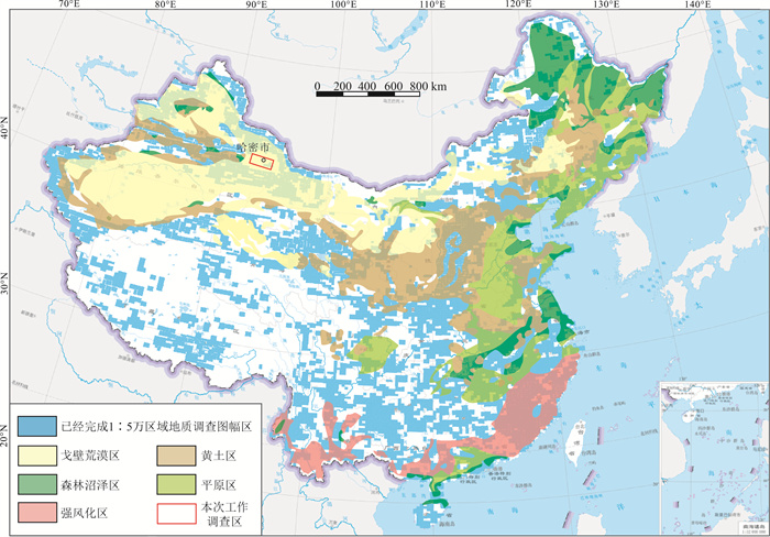
Figure 1.
Distribution of different of coverage areas in China and study area
-
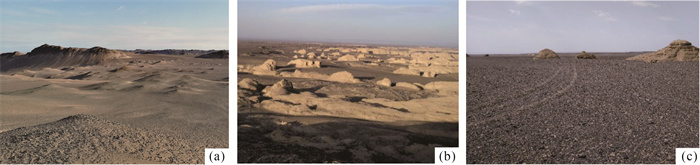
Figure 2.
Geological and geomorphological characteristics of the Gobi desert in Hami area, East Tianshan
-
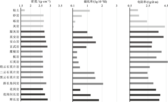
Figure 3.
Physical parameters of main rock types in the Hongqiuling sheet in Hami area
-
Figure 4.
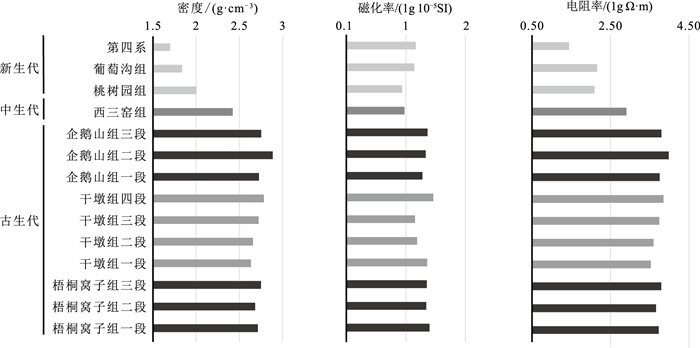
Physical property parameters of main stratigraphic mapping units in the Hongqiuling sheet in Hami area
-
Figure 5.
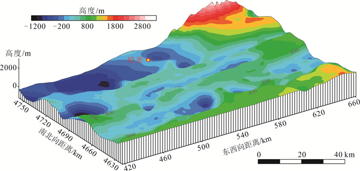
3D morphological map of the pre-Mesozoic bedrock surface(bottom of overburden)in Hami area
-
Figure 6.
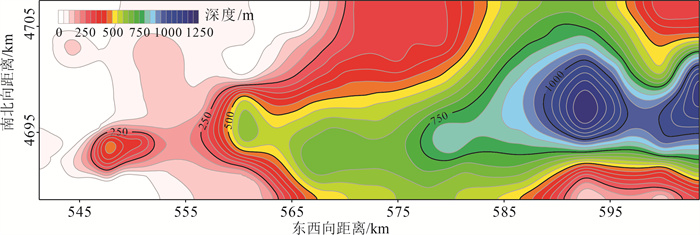
Depth map of bedrock top and cover bottom of Yandun block in Hami area, according to gravity and magnetic data
-
Figure 7.
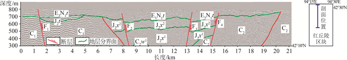
The shallow reflection seismic section which revealing the thickness, structure of cover and bedrock distribution in the Hongqiuling sheet of Hami area
-
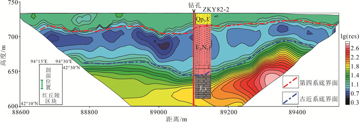
Figure 8.
High-density electrical section and drilling verification which showing the thickness and structure of cover in the Hongqiuling sheet of Hami area
-
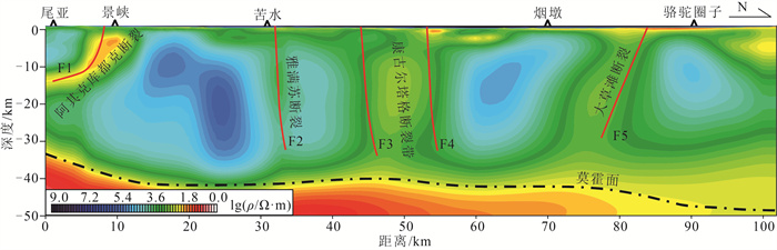
Figure 9.
Two-dimensional NLCG inversion electrical structure model of the MT sounding profile in Weiya-Namiaoergou, East Tianshan
-
Figure 10.
Faults inferred map according to the linear feature of the gravity anomaly(a) and aeromagnetic anomaly(b)in the Hongqiuling sheet of Hami area
-
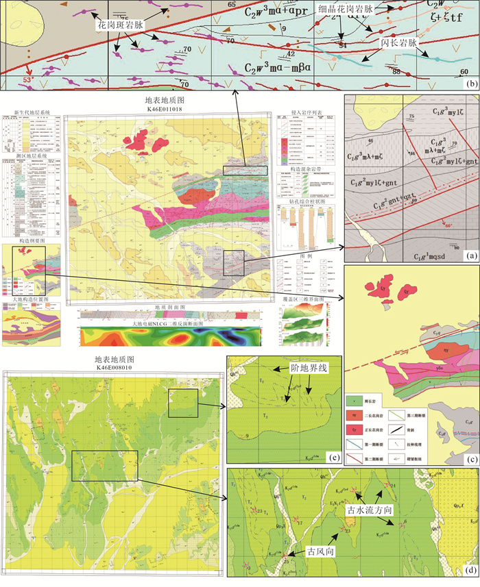
Figure 11.
Expression of surface geological map
-
Figure 12.
Representation of the bedrock geological map
-
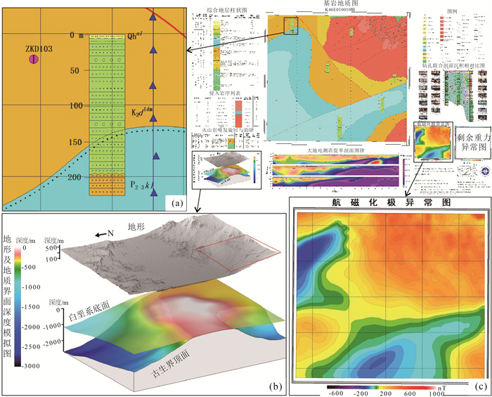
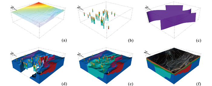
Figure 13.
Schematic diagram of 3D geological structure modeling for Changgan River sheet by GeoModeller software in Hami area