
| Qingdao Institute of marine geology, China Geological Survey | Host |
| Citation: |
CHEN Qi, ZHANG Yang, TANG Wenwen, ZHU Yonglan, HE Fangting, ZONG Yibing, JIA Jianjun. Application of low-altitude airspace UAVs in beach terrain monitoring[J]. Marine Geology & Quaternary Geology, 2023, 43(6): 55-68. doi: 10.16562/j.cnki.0256-1492.2023073001

|
Application of low-altitude airspace UAVs in beach terrain monitoring
-
Abstract
With the development of consumer-grade unmanned aerial vehicles (UAVs), new possibilities for beach monitoring are now available. However, different monitoring accuracies and suitability exist across different UAV platforms. We employed two UAV platforms, namely the DJI Phantom 4 RTK and DJI M300 RTK, in combination with two terrain monitoring techniques: Structure from Motion (SFM) photogrammetry and Light Detection and Ranging (LIDAR), to undertake beach terrain monitoring at Dasha Beach in Xiangshan County, Zhejiang, East China. The planimetric and elevation errors of low-altitude UAV measurements were assessed. Differences among the synchronously monitored results of diverse UAV platforms were analyzed, and their respective application scenarios were discussed. Additionally, we analyzed beach terrain characteristics and investigated beach terrain variations before and after winter. The analysis results show that the drone platform is capable of performing high-precision monitoring of beach topographic changes.
-

-
References
[1] 中华人民共和国国家质量监督检验检疫总局, 中国国家标准化管理委员会. GB/T 18190-2017 海洋学术语 海洋地质学[S]. 北京: 中国标准出版社, 2017 General Administration of Quality Supervision, Inspection and Quarantine of the People's Republic of China, Standardization Administration of the People's Republic of China. GB/T 18190-2017 Oceanological Terminology—Marine Geology[S]. Beijing: Standards Press of China, 2017. [2] Chen B Q, Yang Y M, Wen H T, et al. High-resolution monitoring of beach topography and its change using unmanned aerial vehicle imagery[J]. Ocean & Coastal Management, 2018, 160:103-116. [3] 蔡锋, 苏贤泽, 刘建辉, 等. 全球气候变化背景下我国海岸侵蚀问题及防范对策[J]. 自然科学进展, 2008, 18(10):1093-1103 doi: 10.3321/j.issn:1002-008X.2008.10.002 CAI Feng, SU Xianze, LIU Jianhui, et al. The countermeasures of coastal erosion based on the global climate change[J]. Progress in Natural Science, 2008, 18(10):1093-1103. doi: 10.3321/j.issn:1002-008X.2008.10.002 [4] Luijendijk A, Hagenaars G, Ranasinghe R, et al. The state of the world's beaches[J]. Scientific Reports, 2018, 8(1):6641. doi: 10.1038/s41598-018-24630-6 [5] Vousdoukas M I, Ranasinghe R, Mentaschi L, et al. Sandy coastlines under threat of erosion[J]. Nature Climate Change, 2020, 10(3):260-263. doi: 10.1038/s41558-020-0697-0 [6] 李兵, 蔡锋, 曹立华, 等. 福建砂质海岸侵蚀原因和防护对策研究[J]. 台湾海峡, 2009, 28(2):156-162 LI Bing, CAI Feng, CAO Lihua, et al. Causes of beach erosion in Fujian and preventions[J]. Journal of Oceanography in Taiwan Strait, 2009, 28(2):156-162. [7] 王广禄, 蔡锋, 苏贤泽, 等. 泉州市砂质海岸侵蚀特征及原因分析[J]. 台湾海峡, 2008, 27(4):547-554 WANG Guanglu, CAI Feng, SU Xianze, et al. Characters of sand beach erosion in Quanzhou and it causes[J]. Journal of Oceanography in Taiwan Strait, 2008, 27(4):547-554. [8] 罗时龙, 蔡锋, 王厚杰. 海岸侵蚀及其管理研究的若干进展[J]. 地球科学进展, 2013, 28(11):1239-1247 LOU Shilong, CAI Feng, WANG Houjie. Development of coastal erosion and management[J]. Advances in Earth Science, 2013, 28(11):1239-1247. [9] 王颖, 吴小根. 海平面上升与海滩侵蚀[J]. 地理学报, 1995, 50(2):118-127 doi: 10.3321/j.issn:0375-5444.1995.02.003 WANG Ying, WU Xiaogen. Sea level rise and beach response[J]. Acta Geographica Sinica, 1995, 50(2):118-127. doi: 10.3321/j.issn:0375-5444.1995.02.003 [10] Muzirafuti A, Randazzo G, Lanza S. UAV application for coastal area monitoring: a case study of Sant’Alessio Siculo, Sicily[C]//Proceedings of 2022 IEEE International Workshop on Metrology for the Sea; Learning to Measure Sea Health Parameters (MetroSea). Milazzo: IEEE, 2022: 143-147. [11] Baily B, Nowell D. Techniques for monitoring coastal change: a review and case study[J]. Ocean & Coastal Management, 1996, 32(2):85-95. [12] Westoby M J, Lim M, Hogg M, et al. Cost-effective erosion monitoring of coastal cliffs[J]. Coastal Engineering, 2018, 138:152-164. doi: 10.1016/j.coastaleng.2018.04.008 [13] Turner I L, Harley M D, Short A D, et al. A multi-decade dataset of monthly beach profile surveys and inshore wave forcing at Narrabeen, Australia[J]. Scientific Data, 2016, 3(1):160024. doi: 10.1038/sdata.2016.24 [14] Feagin R A, Williams A M, Popescu S, et al. The use of terrestrial laser scanning (TLS) in dune ecosystems: the lessons learned[J]. Journal of Coastal Research, 2014, 30(1):111-119. [15] Brooks S M, Spencer T. Temporal and spatial variations in recession rates and sediment release from soft rock cliffs, Suffolk coast, UK[J]. Geomorphology, 2010, 124(1-2):26-41. doi: 10.1016/j.geomorph.2010.08.005 [16] Pardo-Pascual J E, Almonacid-Caballer J, Ruiz L A, et al. Automatic extraction of shorelines from Landsat TM and ETM+ multi-temporal images with subpixel precision[J]. Remote Sensing of Environment, 2012, 123:1-11. doi: 10.1016/j.rse.2012.02.024 [17] Pierre G. Processes and rate of retreat of the clay and sandstone sea cliffs of the northern Boulonnais (France)[J]. Geomorphology, 2006, 73(1-2):64-77. doi: 10.1016/j.geomorph.2005.07.002 [18] Montreuil A L, Bullard J, Chandler J. Detecting seasonal variations in embryo dune morphology using a terrestrial laser scanner[J]. Journal of Coastal Research, 2013, 65(sp2):1313-1318. [19] Grohmann C H, Garcia G P B, Affonso A A, et al. Dune migration and volume change from airborne LiDAR, terrestrial LiDAR and Structure from Motion-Multi View Stereo[J]. Computers & Geosciences, 2020, 143:104569. [20] Troy C D, Cheng Y T, Lin Y C, et al. Rapid lake Michigan shoreline changes revealed by UAV LiDAR surveys[J]. Coastal Engineering, 2021, 170:104008. doi: 10.1016/j.coastaleng.2021.104008 [21] 毕海芸, 郑文俊, 曾江源, 等. SfM摄影测量方法在活动构造定量研究中的应用[J]. 地震地质, 2017, 39(4):656-674 doi: 10.3969/j.issn.0253-4967.2017.04.003 BI Haiyun, ZHENG Wenjun, ZENG Jiangyuan, et al. Application of SfM photogrammetry method to the quantitative study of active tectonics[J]. Seismology and Geology, 2017, 39(4):656-674. doi: 10.3969/j.issn.0253-4967.2017.04.003 [22] 魏占玉, Ramon A, 何宏林, 等. 基于SfM方法的高密度点云数据生成及精度分析[J]. 地震地质, 2015, 37(2):636-648 WEI Zhanyu, Ramon A, HE Honglin, et al. Accuracy analysis of terrain point cloud acquired by “structure from motion” using aerial photos[J]. Seismology and Geology, 2015, 37(2):636-648. [23] Pitman S J, Hart D E, Katurji M H. Application of UAV techniques to expand beach research possibilities: a case study of coarse clastic beach cusps[J]. Continental Shelf Research, 2019, 184:44-53. doi: 10.1016/j.csr.2019.07.008 [24] 郭一栋, 林杭杰, 于谦, 等. 基于无人机SfM摄影测量的海岸盐沼前缘形态变化研究[J]. 海洋学报, 2022, 44(12):148-160 GUO Yidong, LIN Hangjie, YU Qian et al. Morphology of coastal salt marsh margins: a study using UAV-based Structure-from-Motion photogrammetry[J]. Haiyang Xuebao, 2022, 44(12):148-160. [25] Westoby M J, Brasington J, Glasser N F, et al. ‘Structure-from-Motion’ photogrammetry: a low-cost, effective tool for geoscience applications[J]. Geomorphology, 2012, 179:300-314. doi: 10.1016/j.geomorph.2012.08.021 [26] 国家市场监督管理总局, 中国国家标准化管理委员会. GB/T 35018-2018 民用无人驾驶航空器系统分类及分级[S]. 北京: 中国标准出版社, 2018 State Administration for Market Regulation, Standardization Administration of the People's Republic of China. GB/T 35018-2018 Classification and grading for civil unmanned aircraft system[S]. Beijing: Standards Press of China, 2018. [27] 中华人民共和国国家质量监督检验检疫总局, 中国国家标准化管理委员会. GB/T 14950-2009 摄影测量与遥感术语[S]. 北京: 中国标准出版社, 2009 General Administration of Quality Supervision, Inspection and Quarantine of the People's Republic of China, Standardization Administration of the People's Republic of China. GB/T 14950-2009 Terms of photogrammetry and remote sensing[S]. Beijing: Standards Press of China, 2009. [28] 国家市场监督管理总局, 中国国家标准化管理委员会. GB/T 39612-2020 低空数字航摄与数据处理规范[S]. 北京: 中国标准出版社, 2020 State Administration for Market Regulation, Standardization Administration of the People's Republic of China. GB/T 39612-2020 Specifications for low-altitude digital aerial photography and data processing[S]. Beijing: Standards Press of China, 2020. [29] 中国民用航空局. 中国民用航空总局规章目录[EB/OL]. (2008-01-20)[2023-07-19]. http://www.caac.gov.cn/XXGK/XXGK/ZFGW/201601/t20160122_27768.html Civil Aviation Administration of China. Catalogue of regulations of the Civil Aviation Administration of China[EB/OL]. (2008-01-20)[2023-07-19]. http://www.caac.gov.cn/XXGK/XXGK/ZFGW/201601/t20160122_27768.html. [30] 贝京阳, 陈杲, 俞晓天. 浙江省南田岛附近潮流特征分析[J]. 海洋湖沼通报, 2022, 44(5):60-66 BEI Jingyang, CHEN Gao, YU Xiaotian. Characterization of tidal current near Nantian Island, Zhejiang province[J]. Transactions of Oceanology and Limnology, 2022, 44(5):60-66. [31] 象山县地方志编纂委员会. 象山县志: 第一册[M]. 北京: 方志出版社, 2020: 405-407 Xiangshan County Local Records Committee. Xiangshan County Annals: Volume 1[M]. Beijing: Local Records Publishing House, 2020: 405-407. [32] Laporte-Fauret Q, Marieu V, Castelle B, et al. Low-cost UAV for high-resolution and large-scale coastal dune change monitoring using photogrammetry[J]. Journal of Marine Science and Engineering, 2019, 7(3):63. doi: 10.3390/jmse7030063 [33] Jaud M, Delacourt C, Le Dantec N, et al. Diachronic UAV photogrammetry of a sandy beach in Brittany (France) for a long-term coastal observatory[J]. ISPRS International Journal of Geo-Information, 2019, 8(6):267. doi: 10.3390/ijgi8060267 [34] Mancini F, Dubbini M, Gattelli M, et al. Using unmanned aerial vehicles (UAV) for high-resolution reconstruction of topography: the structure from motion approach on coastal environments[J]. Remote Sensing, 2013, 5(12):6880-6898. doi: 10.3390/rs5126880 [35] Fonstad M A, Dietrich J T, Courville B C, et al. Topographic structure from motion: a new development in photogrammetric measurement[J]. Earth Surface Processes and Landforms, 2013, 38(4):421-430. doi: 10.1002/esp.3366 [36] Jaud M, Grasso F, Le Dantec N, et al. Potential of UAVs for monitoring mudflat morphodynamics (application to the seine estuary, France)[J]. ISPRS International Journal of Geo-Information, 2016, 5(4):50. doi: 10.3390/ijgi5040050 -
Access History

Figures(9)
Tables(6)

Export File
Citation
CHEN Qi, ZHANG Yang, TANG Wenwen, ZHU Yonglan, HE Fangting, ZONG Yibing, JIA Jianjun. Application of low-altitude airspace UAVs in beach terrain monitoring[J]. Marine Geology & Quaternary Geology, 2023, 43(6): 55-68. doi: 10.16562/j.cnki.0256-1492.2023073001
Format
Content
 DownLoad:


-
Figure 1.
Location of Dasha Beach and the monitoring areas
-
Figure 2.
SFM photogrammetric flight lines and distribution of the mapping quality points at Dasha Beach
-
Figure 3.
Accuracy and error at validation points
-
Figure 4.
Quasi-synchronous monitoring results and their comparison of beach elevations
-
Figure 5.
Comparison of quasi-synchronous monitoring profiles
-
Figure 6.
Two-phase beach topography monitoring results and comparison under the same platform and parameters
-
Figure 7.
Monitoring results of beach profiles for Flight A and Flight B
-
Figure 8.
The elevation errors at validation points of different monitoring data
-
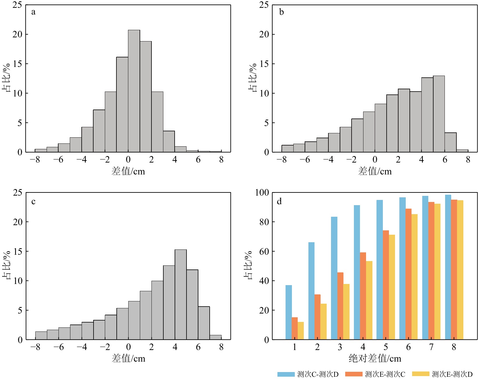
Figure 9.
Histogram of differences distribution from quasi-synchronous monitoring