
| Qingdao Institute of marine geology, China Geological Survey | Host |

| Citation: |
ZOU Jianwen, HUANG Mingquan, LI Xuecheng, WANG Shang. Application of AR technology for underwater positioning and survey[J]. Marine Geology Frontiers, 2023, 39(11): 86-93. doi: 10.16028/j.1009-2722.2022.330

|
Application of AR technology for underwater positioning and survey
-
Abstract
Augmented Reality (AR) is a new technology for a wide range of applications, which involves many areas of social life, such as medicine, military, transportation, education, entertainment, industrial machinery, landscape planning, cultural relic protection, etc., and has also been applied for underwater engineering at present. AR has been successfully applied for underwater positioning and survey in ocean engineering for the first time in China. An ROV (remotely operated vehicle) is equipped as a carrier with a 3D camera and relevant underwater sensors. Through the unique AR software, the structural 3D model, virtual markers, and virtual measurement tools could be superimposed onto the video images transmitted from underwater to the ground surface, with which the real-time communication between the operators on the ground and the real underwater environment and real-time monitoring on position and attitude of underwater structures could be realized. The application of AR in underwater positioning and survey breaks by traditional operation method showed high precision, high efficiency, low cost, non-contact, and real-time measurement. In addition, the ROV does not need to cling to the structure, the software is easy to operate, the measurement data are reliable and real-time display, which could effectively reduce the operation risk of ROV and improve the working efficiency.
-

-
References
[1] 范刚,张亚,赵河明,等. 水下机器人定位导航技术发展现状与分析[J]. 兵器装备工程学报,2022,43(3):22-29. doi: 10.11809/bqzbgcxb2022.03.003 [2] 石腾. 水下机器人短基线定位系统设计与实现[D]. 哈尔滨: 哈尔滨工程大学, 2018. [3] 金博楠,徐晓苏,张涛,等. 超短基线定位技术及在海洋工程中的应用[J]. 导航定位与授时,2018,5(4):8-20. doi: 10.19306/j.cnki.2095-8110.2018.04.002 [4] 狄冰,高辉,徐亚国. 长基线定位系统在海洋油气开发中的应用[J]. 北京石油化工学院学报,2015,23(4):35-39. doi: 10.3969/j.issn.1008-2565.2015.04.008 [5] 张同伟,秦升杰,唐嘉陵,等. 深海长基线定位系统现状及展望[J]. 测绘通报,2018,10:75-78,106. doi: 10.13474/j.cnki.11-2246.2018.0319 [6] 李璇,解禹. 水下定位导航系统展望[J]. 无人系统技术,2022,5(3):79-86. doi: 10.19942/j.issn.2096-5915.2022.3.029 [7] PARENTE M, STEVENS M, FERREIRA J, et al. Subsea digitalization: from the virtual world into the real world—using Augmented Reality in offshore operations[C]//Houston:Offshore Technology Conference, 2019. [8] CHOI S,PARK J S. Development of Augmented Reality system for productivity enhancement in offshore plant construction[J]. Journal of Marine Science and Engineering,2021,9(2):209. doi: 10.3390/jmse9020209 [9] 邱博文. 基于二维码标识的增强现实系统的设计与实现[D]. 西安: 西安电子科技大学, 2014. [10] BOONBRAHM S,BOONBRAHM P,KAEWRAT C. The use of marker-based Augmented Reality in space measurement[J]. Procedia Manufacturing,2020,42:337-343. [11] BRUNO F,BARBIERI L,MANGERUGA M,et al. Underwater Augmented Reality for improving the diving experience in submerged archaeological sites[J]. Ocean Engineering,2019,190:106487. [12] ISHIDA M, SHIMONOMURA K. Marker based camera pose estimation for underwater robots[C]//2012 IEEE/SICE International Symposium on System Integration (SII). IEEE, 2012: 629-634. [13] HENRIKSEN E H, SCHJøLBERG I, GJERSVIK T B. Vision based localization for subsea intervention[C]//International Conference on Offshore Mechanics and Arctic Engineering.Trondheim: American Society of Mechanical Engineers, 2017, 7: V07AT06A023. [14] 刘佳,郭斌,张晶晶,等. 视触觉融合的增强现实三维注册方法[J]. 计算机工程与应用,2021,57(11):70-76. doi: 10.3778/j.issn.1002-8331.2005-0160 [15] 黄明泉,徐景平,施林炜. ROV在海洋油气田开发中的应用及展望[J]. 海洋地质前沿,2021,37(2):77-84. doi: 10.16028/j.1009-2722.2020.030 -
Access History
Figures(11)
Tables(4)

Export File
Citation
ZOU Jianwen, HUANG Mingquan, LI Xuecheng, WANG Shang. Application of AR technology for underwater positioning and survey[J]. Marine Geology Frontiers, 2023, 39(11): 86-93. doi: 10.16028/j.1009-2722.2022.330
Format
Content
 DownLoad:


-
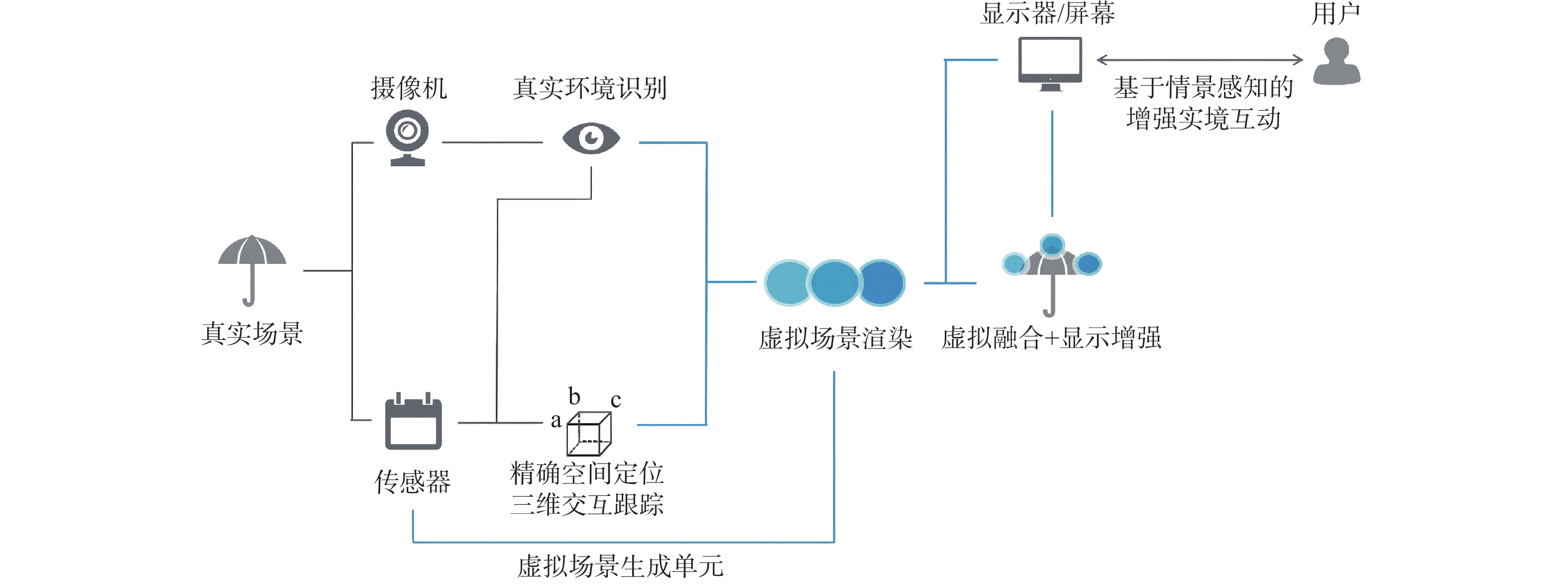
Figure 1.
Schematic of AR system structure and working principle
-
Figure 2.
The 3D camera of the Fugro machine vision
-
Figure 3.
The QR code stuck onto the underwater structure
-
Figure 4.
The working pattern of the QR code
-
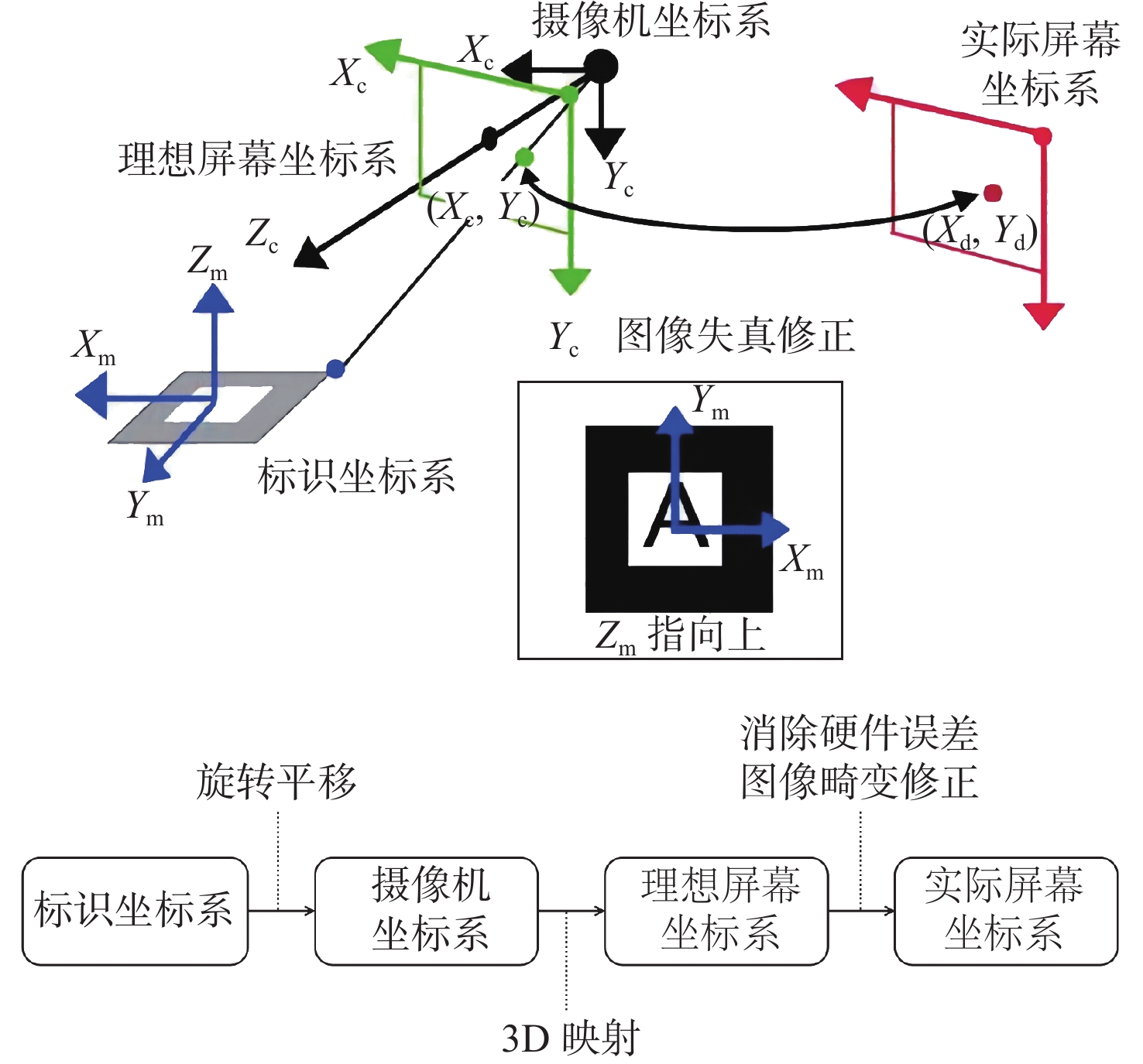
Figure 5.
Example of axis correction from QR pattern to structure reference frame
-
Figure 6.
Schematic of coordinate system transformation[14]
-
Figure 7.
Virtual structure model used for underwater positioning
-
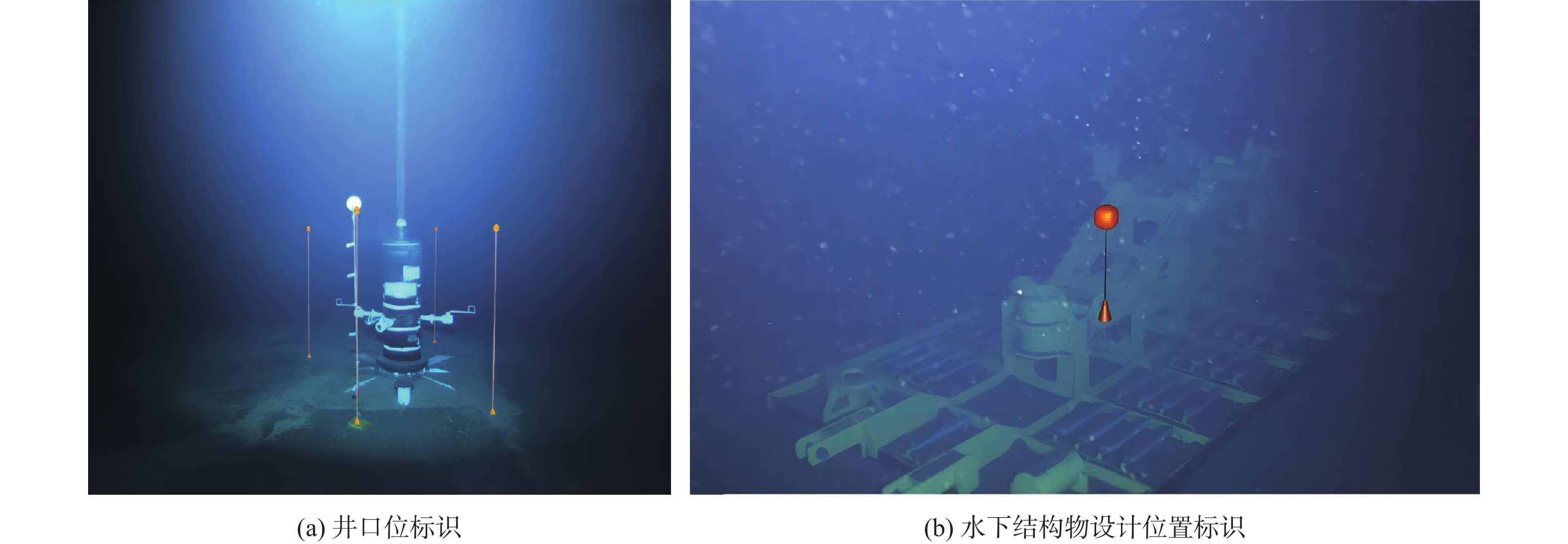
Figure 8.
Virtual buoys used for underwater marking
-
Figure 9.
Virtual cylinder used for guiding conductor installation
-
Figure 10.
Virtual tool used for measuring underwater structure attitude
-
Figure 11.
Real-time monitoring of BOP landing on wellhead