
| Qingdao Institute of marine geology, China Geological Survey | Host |

| Citation: |
SHENG Shiqiang, DAI Liming, LI Fakun, LI Juhong. 3D geological modeling of the 428 Tectonic Zone in Bozhong Depression using GOCAD software[J]. Marine Geology Frontiers, 2023, 39(3): 91-100. doi: 10.16028/j.1009-2722.2022.034

|
3D geological modeling of the 428 Tectonic Zone in Bozhong Depression using GOCAD software
-
Abstract
The 428 tectonic zone is a buried hill, located in the central part of Bozhong Depression in Bohai Bay basin, and is the result of multi-stage fold superposition and extensional fracture. How to understand the three-dimensional geometric features of the buried hill is very important to reveal the superposition-remodeling process in different tectonic stages and the development of deep oil and gas reservoirs. In this paper, a 3D geological model of the 428 tectonic zone was constructed based on 3D seismic and drilling data using 3D geological modeling software GOCAD. By comparing and analyzing the stratigraphic distribution and fault development in the model, we identified the fold deformation pattern of the 428 tectonic zone and its peripheral area, as well as the intersection of inner faults in the 428 tectonic zone. The eastern 428 tectonic zone is a uni-structural belt where the Paleozoic strata overlay the Archean basement, while the western 428 tectonic zone is a dual- structural belt where the Paleozoic and Mesozoic strata sit on the Archean basement. The fold deformation patterns of the two belts reflect the superposition of Indosinian and Yanshanian folding processes.
-
Keywords:
- Bozhong Depression /
- 428 buried hill /
- fold /
- 3D geological model /
- GOCAD
-

-
References
[1] 吴志春, 郭福生, 姜勇彪, 等. 基于地质剖面构建三维地质模型的方法研究[J]. 地质与勘探, 2016, 52(2): 363-375. [2] 陈麒玉, 刘刚, 何珍文, 等. 面向地质大数据的结构-属性一体化三维地质建模技术现状与展望[J]. 地质科技通报, 2020, 39(4): 51-58. [3] 陈国旭,田宜平,张夏林,等. 基于勘探剖面的三维地质模型快速构建及不确定性分析[J]. 地质科技情报,2019,38(2):275-280. [4] 张文彪, 段太忠, 刘彦锋, 等. 定量地质建模技术应用现状与发展趋势[J]. 地质科技情报, 2019, 38(3): 264-275. [5] KUMAR T S S. Resource modelling of iron ore deposit using Surpac software[J]. Journal of the Geological Society of India, 2021, 97(5): 559. [6] 罗周全,吴亚斌,刘晓明,等. 基于SURPAC的复杂地质体FLAC3D模型生成技术[J]. 岩土力学,2008,29(5):1334-1338. [7] BACHIR S A M. 中国南海珠江口盆地白云凹陷番禺低凸起热史模拟及油气运移分析[D]. 武汉: 中国地质大学, 2006. [8] 陈承声, 史树勇, 王云鹏. 基于PetroMod四川盆地长宁地区五峰-龙马溪组优质页岩段吸附模拟研究[J]. 地球化学, 2019, 48(6): 602-612. [9] 廖玲玲, 王云鹏. 利用包裹体PVTx和PetroMod盆地模拟系统反演鄂尔多斯盆地上古生界古流体压力[J]. 矿物岩石地球化学通报, 2015, 34(5): 955-959. [10] 卢大超, 付友山. 三维矿产资源评价软件MICROMINE在金属矿山资源储量估算中的应用: 以吉林舒兰季德钼矿为例[J]. 世界地质, 2010, 29(3): 450-458. [11] 郑文宝, 黎枫佶, 唐菊兴, 等. 基于Micromine软件下地质统计学在甲玛矽卡岩型铜多金属矿储量计算中的应用[J]. 地质与勘探, 2011, 47(4): 726-736. [12] 赵增玉, 陈火根, 潘懋, 等. 基于GOCAD的宁芜盆地云台山地区三维地质建模[J]. 地质学刊, 2014, 38(4): 652-656. [13] 刘智勇. 曲面插值算法在三维地质建模中的研究[D]. 成都: 成都理工大学, 2016. [14] 王长海, 陈碧宇. 基于离散光滑插值的三维地质体构造网格模型[J]. 深圳大学学报(理工版), 2014, 31(6): 600-607. [15] 王金艳, 鲁人齐, 张浩, 等. 郯庐断裂带江苏段新生界三维地质构造建模[J]. 地震学报, 2020, 42(2): 216-230. [16] 徐春强, 张震, 王晨杰, 等. 渤海海域428潜山地层结构特征及勘探潜力[J]. 海洋地质前沿, 2020, 36(11): 52-58. [17] 王宇, 徐春强, 郭玲莉, 等. 渤海湾盆地石臼坨东428潜山构造成因解析: 华北克拉通破坏的深度揭示[J]. 大地构造与成矿学, 2021, 45(1): 219-228. [18] 武子涵,于海波,张参,等. 渤海湾盆地中部428构造带近S-N向走滑断裂的形成时期及其在中生代期间的调节转换作用[J]. 海洋地质与第四纪地质,2023,43(1):71-81. -
Access History

Figures(10)

Export File
Citation
SHENG Shiqiang, DAI Liming, LI Fakun, LI Juhong. 3D geological modeling of the 428 Tectonic Zone in Bozhong Depression using GOCAD software[J]. Marine Geology Frontiers, 2023, 39(3): 91-100. doi: 10.16028/j.1009-2722.2022.034
Format
Content
 DownLoad:


-
Figure 1.
Workflow chart of structure and stratigraphy modeling[15]
-
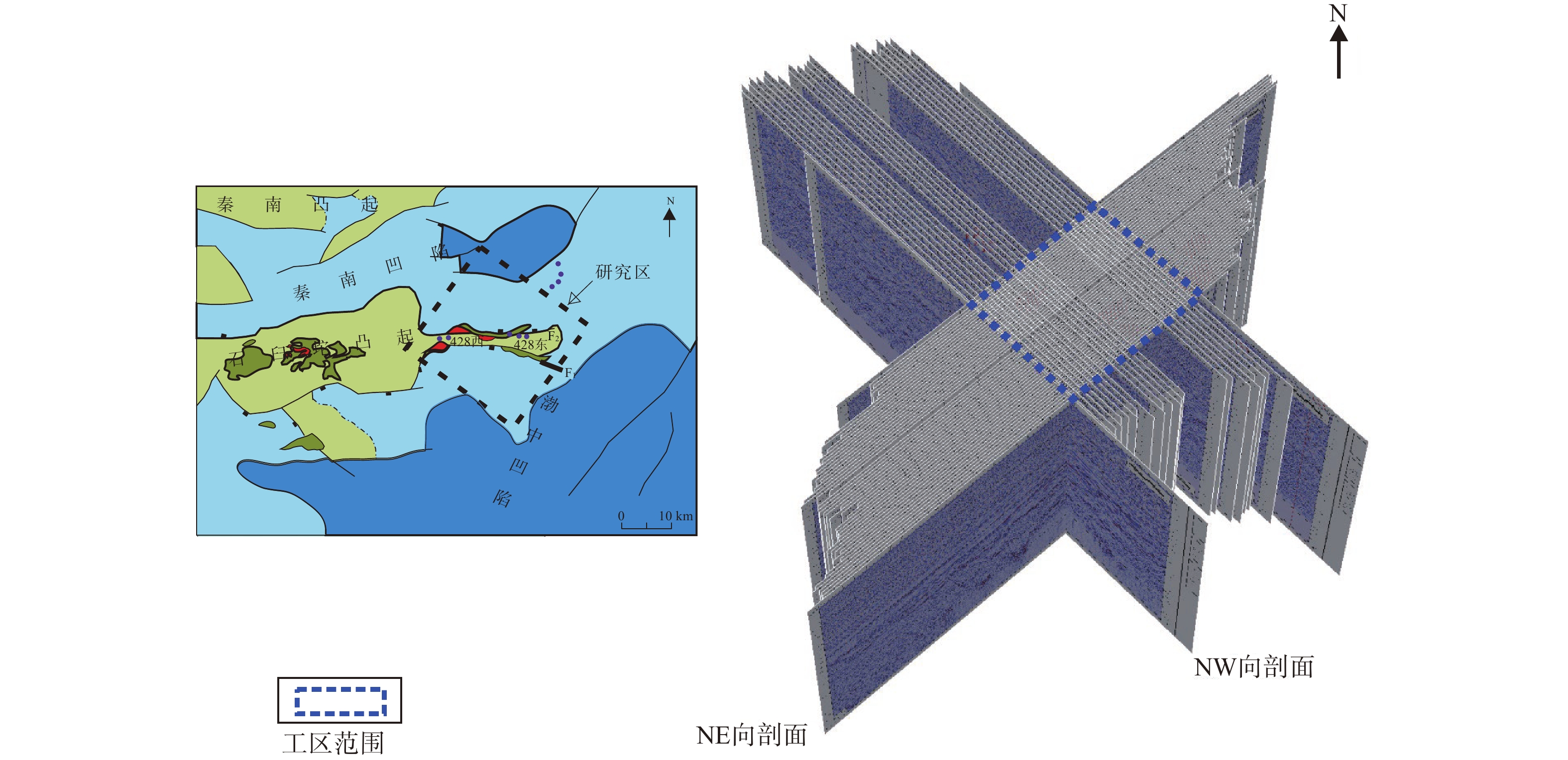
Figure 2.
Tectonic overview and seismic profile of the study area
-
Figure 3.
The stratigraphic framework of the study area
-
Figure 4.
The scope of seismic profile interpretation for the study area
-
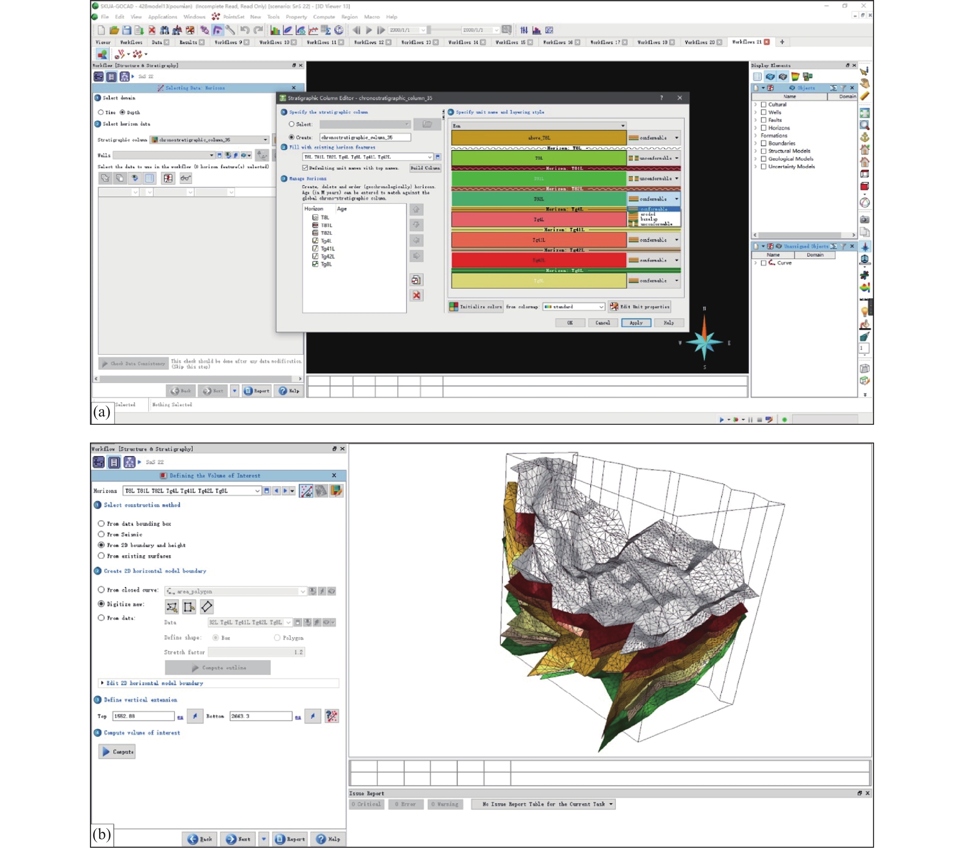
Figure 5.
The basic processes of creating the 3D geological model
-
Figure 6.
Basic processes for creating the 3D geological model of 428 tectonic
-
Figure 7.
Creating faults, stratigraphic grids and generating 3D models
-
Figure 8.
Spatial three-dimensional geometry of the 428 tectonic zone
-
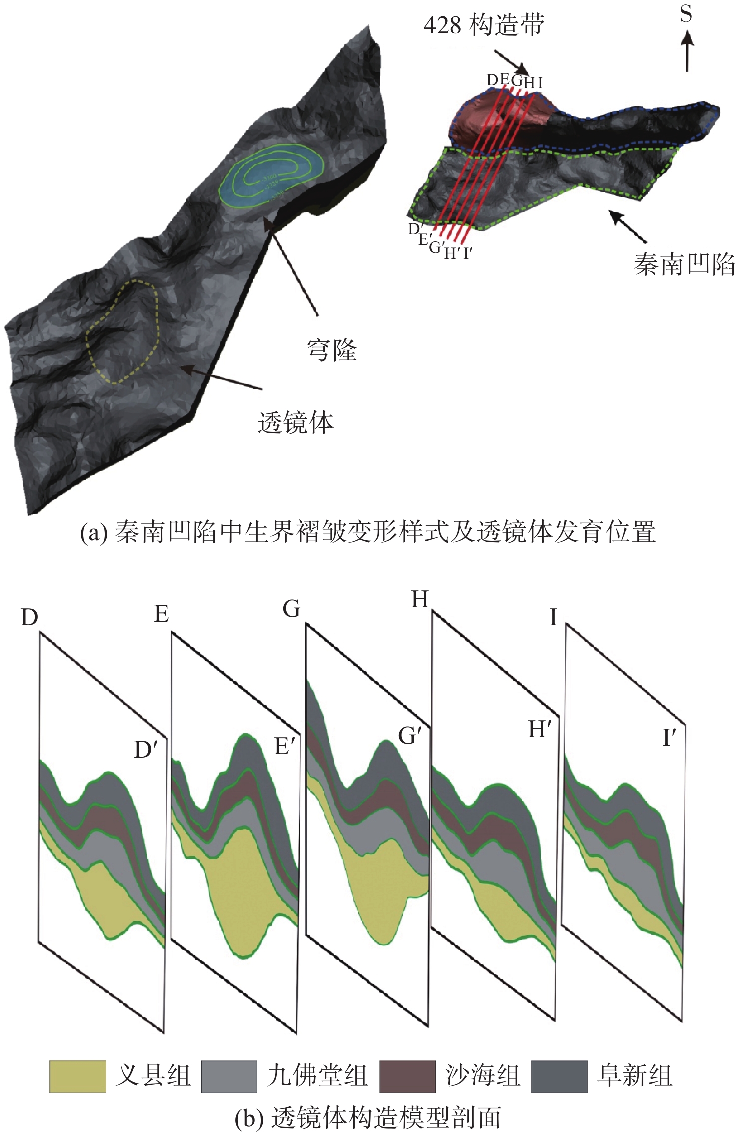
Figure 9.
Differences in style and deformation of folds in the Bozhong Depression south of the 428 tectonic zone
-
Figure 10.
Spatial geometric features of folds in the Qinnan Depression north of the 428 tectonic zone