

| Citation: |
LIU Chuanzheng, CUI Yuan, CHEN Chunli, LYU Jietang, LI Bing, WANG Lun. Research on the south side landslide at west open-pit coal mine in Fushun City, Liaoning Province of China[J]. Geological Bulletin of China, 2022, 41(5): 713-726. doi: 10.12097/j.issn.1671-2552.2022.05.001

|
Research on the south side landslide at west open-pit coal mine in Fushun City, Liaoning Province of China
-
Abstract
The west open-pit coal mine at Fushun in Liaoning Province of China was opened in 1901 and closed in 2018.It formed a 420 meters bottomless pit due to stepped coal mining, therefore, is called the largest pit in Asia.The south side landslide in the open-pit coal mine is a giant bedding rock landslide with 3100 meters in length from east to west and 1500 meters in width from north to south.The volume of the landslide is about 452 million cubic meters.Rainfall seepage and excavation unloading at the bottom of the mine are the main factors that lead to the landslide and the continuous long-distance movement.The concrete manifestation includes interlayer softening, groundwater buoyancy, and pore water pressure in the middle and front parts of the slope.The monitoring data from 2012 to 2019 show that the maximum horizontal displacement of the landslide is 96.01 meters, the cumulative maximum subsidence is 56.65 meters, and the full raise of the front edge is 23.61 meters.The topographic feature of the landslide area is greatly changed.The landslide movement has experienced deformation and failure before 2013, step evolution from 2013 to 2016, and gradually stabilization since 2017.The three phases reflect the rapid development of the giant landslide from the complete destruction of the bedding mountain to a gradually stable process.Analysis of the sensibility reveals the uplifting of underground water level plays an important role in decreasing slope stability, and filling soil at the toe of the slope remarkably increase slope stability.Bedding sliding resistance in the middle and upper slope, cut-layers shear resistance in the lower slope, fill pressure in leading edge, boundary resistance of bilateral, and counterforce of the north side are major factors of the gradual braking of landslide.It is manifested as the "block effect" of the boundary and the "pressure arch effect" of the leading edge.Using boundary resistance, stowage, and resistance reaction force to control the landslide process is typical.The impact and vibration effects were avoided, and the soft landing was realized.
-

-
References
[1] 刘传正. 中国崩塌滑坡泥石流灾害成因类型[J]. 地质论评, 2014, 60(4): 858-868. [2] 杨天鸿, 张锋春, 于庆磊, 等. 露天矿高陡边坡稳定性研究现状及发展趋势[J]. 岩土力学, 2011, 32(5): 1437-1452. doi: 10.3969/j.issn.1000-7598.2011.05.025 [3] 刘传正. 地质灾害防治研究的认识论与方法论[J]. 工程地质学报, 2015, 23(5): 809-820. [4] 吴瑞安, 倪嘉伟, 郭长宝, 等. 川西巴塘断裂带黄草坪滑坡形成机制[J]. 地质通报, 2021, 40(12): 1992-2001. [5] 郭长宝, 倪嘉伟, 杨志华, 等. 川西大渡河泸定段大型古滑坡发育特征与稳定性评价[J]. 地质通报, 2021, 40(12): 1981-1991. [6] 闫茂华, 魏云杰, 李亚民, 等. 云南德钦日因卡滑坡孕灾背景及形成机理[J]. 地质通报, 2020, 39(12): 1971-1980. [7] 孔繁强, 卢月, 卢良玉. 抚顺城区段浑河断裂现今活动性研究的述评[J]. 东北地震研究, 2003, 19(3): 42-49. doi: 10.3969/j.issn.1674-8565.2003.03.008 [8] 孔繁强, 王莉, 王永江, 赵晓辉. 浑河断裂抚顺城区段现今活动性观测分析研究[J]. 东北地震研究, 2009, 25(1): 1-7. doi: 10.3969/j.issn.1674-8565.2009.01.001 [9] 马洪超. 浑河断裂活动性对抚顺市区地裂缝的影响[J]. 中国西部科技, 2015, 14(12): 33-36. doi: 10.3969/j.issn.1671-6396.2015.12.009 [10] 卢良玉, 高常波, 李天成, 庞庆研, 卢月. 浑河断裂现今活动性及抚顺城区段的活动特点研究[J]. 东北地震研究, 2001, 17(2): 48-58. doi: 10.3969/j.issn.1674-8565.2001.02.008 [11] 刘传正. 累积变形曲线类型与滑坡预测预报[J]. 工程地质学报. 2021, 29(1): 86-95. [12] 滕超, 王雷, 刘宝华, 等. 辽宁抚顺西露天矿南帮滑坡应力变化规律及影响因素分析[J]. 中国地质灾害与防治学报, 2018, 29(2): 35-42. [13] Hoek E, Bray J W(著). 卢世宗, 李成村, 夏继祥, 等(译). 岩石边坡工程[M]. 北京: 冶金工业出版社, 1983. [14] 高波, 肖平, 张国军. 抚顺西露天矿南帮边坡岩体结构及构造的分析[J]. 露天采矿技术, 2014, (9): 18-21. [15] 韩晓极, 李惠发, 郭霁, 等. 抚顺西露天矿南帮边坡变形机制与稳定性分析[J]. 煤矿安全, 2017, 48(7): 242-245. [16] 胡高建, 杨天鸿, 张飞. 抚顺西露天矿南帮边坡破坏机理及内排压脚措施[J]. 吉林大学学报(地球科学版), 2019, 49(4): 1082-1092. [17] 贺鑫, 崔原, 滕超, 等. 辽宁抚顺西露天矿南帮滑坡变形与地下水位关系[J]. 中国地质灾害与防治学报, 2018, 29(1): 72-77. [18] Morgenstern N R, Prince V. The analysis of the stability of general slip surface[J]. Geotechinque, 1965, 15(1): 79-93. [19] 陈祖煜, 汪小刚, 杨健, 等. 岩质边坡稳定分析——原理、方法、程序[M]. 北京: 中国水利水电出版社, 2005. -
Access History
Figures(21)
Tables(1)

Export File
Citation
LIU Chuanzheng, CUI Yuan, CHEN Chunli, LYU Jietang, LI Bing, WANG Lun. Research on the south side landslide at west open-pit coal mine in Fushun City, Liaoning Province of China[J]. Geological Bulletin of China, 2022, 41(5): 713-726. doi: 10.12097/j.issn.1671-2552.2022.05.001
Format
Content
 DownLoad:


-
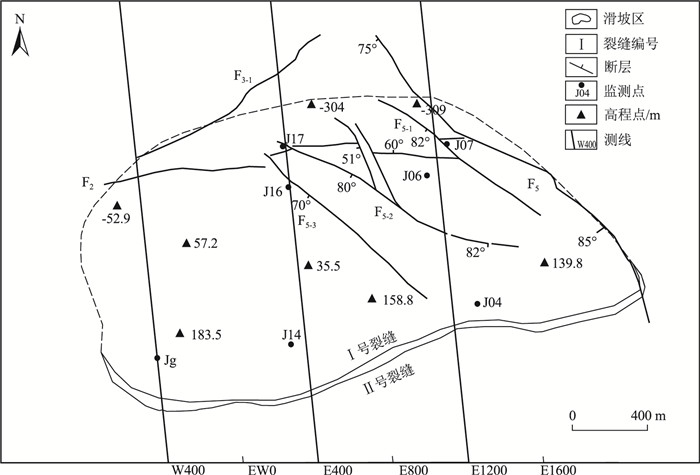
Figure 1.
The plane map of the south side landslide in west open-pit mine at Fushun City
-
Figure 2.
E400 geological section of South side landslide in West open-pit coal mine at Fushun City
-
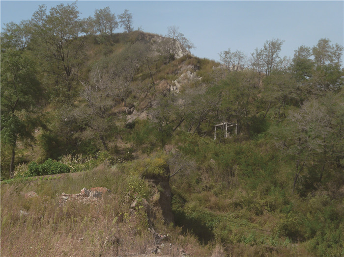
Figure 3.
A crack and sinking zone in middle part of the landslide
-
Figure 4.
Dropped trees in the northern edge of the ground fissure in the landslide
-
Figure 5.
Displacement-time curve of typical monitoring points at the E400(J16)and E1200(J07)sections
-
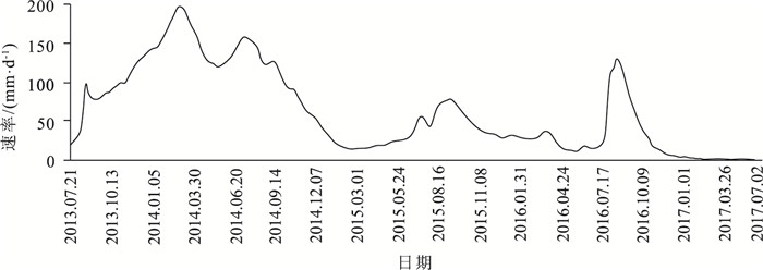
Figure 6.
Mean daily horizontal displacement of Jg monitoring point in Guanlitai area
-
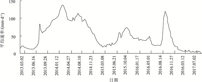
Figure 7.
Mean daily horizontal displacement of J16 monitoring point in the E400 section
-
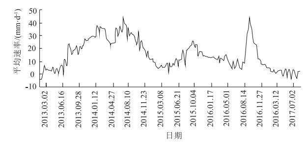
Figure 8.
Mean daily horizontal displacement of J07 monitoring point in the E1200 section
-
Figure 9.
Mean daily vertical displacement of Jg monitoring point in Guanlitai area
-
Figure 10.
Mean daily vertical displacement of J16 monitoring points in the E400 section
-
Figure 11.
Mean daily vertical displacement of J07 monitoring point in the E1200 section
-
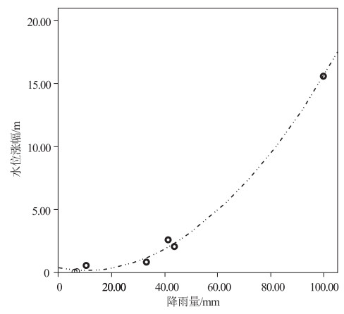
Figure 12.
The rise of groundwater level and the single cumulative rainfall
-
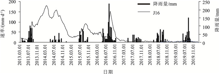
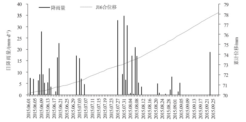
Figure 13.
Cumulative displacement of J16 monitoring point and daily rainfall
-
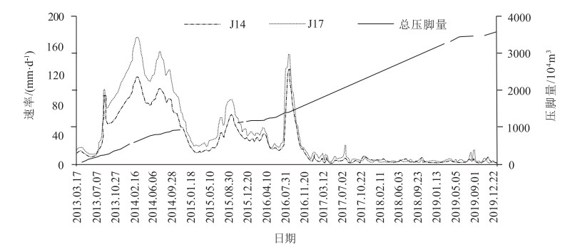
Figure 14.
The horizontal deformation rate of the landslide and the volume of man-made loading
-
Figure 15.
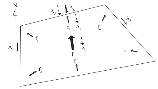
Mechanics model in ichnography of the south side landslide
-
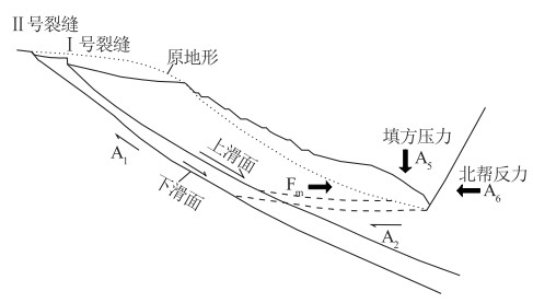
Figure 16.
Mechanics mode of the south side landslide in section
-
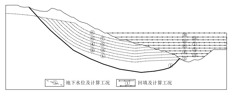
Figure 17.
Calculative model in E1200 section of the landslide
-
Figure 18.
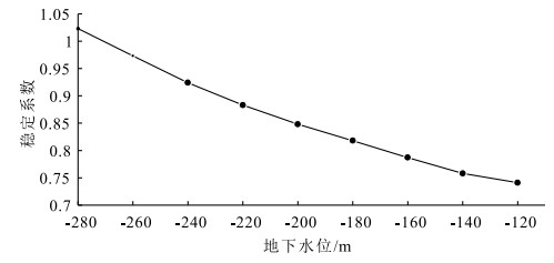
Landslide stability and underground water level lifting of E1200 section
-
Figure 19.
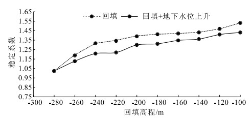
Landslide stability, man-made loading and groundwater level lifting of E1200 section
-
Figure 20.
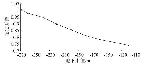
Landslide stability and underground water level lifting of E400 section
-
Figure 21.
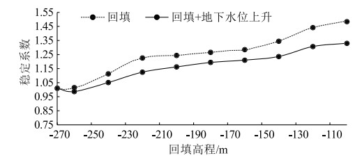
Landslide stability, man-made loading and groundwater level lifting of E400 section