
| Citation: |
XIONG Deqing, CUI Xiaofeng. The relationship between main geological hazard and topography in the Himalayan seismic belt: A case study in the Xigaze area, Xizang[J]. Geological Bulletin of China, 2021, 40(11): 1967-1980.

|
The relationship between main geological hazard and topography in the Himalayan seismic belt: A case study in the Xigaze area, Xizang
-
Abstract
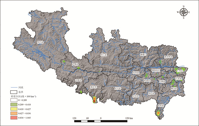
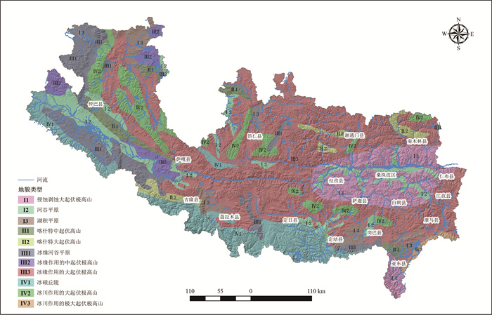
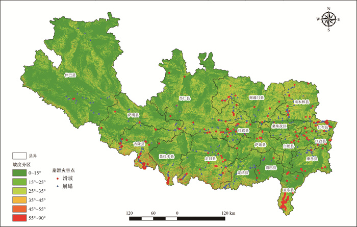
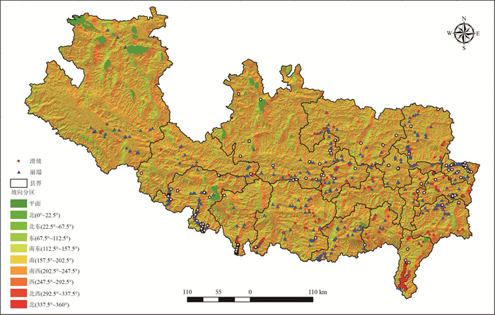
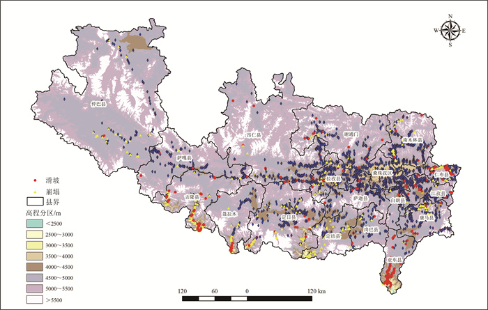
The Himalayas is a huge mountain formed by the collision between the Eurasian plate and the Indian Ocean plate.In the history, there were many earthquakes with magnitude of 7 or more, which caused a large number of secondary geological disasters, and formed complex and diverse landform.Based on the previous data, field surveys and remote sensing interpretation, combined with the geomorphological map of the Himalayas seismic belt (Xigaze section), the powerful data management and spatial analysis capabilities of GIS were used to analyze major geological hazards in the Xigaze area and make maps of geological hazards and density contour.The results show that the main geological disasters are concentratedly distributed in five areas.The main geological disasters occur in strongly denudated and undulating mountains and periglacial extremely undulating mountain landforms, followed by valley plain and moraine hills.Other geomorphic features have less developmental hazards.Landslides and collapses are prone to occur on sunny slopes below 3500 m (90°~270°), and are most sensitive on the southeast-trending slope.Landslides and collapses are prone to occur at slopes of 15°~45° and 35°~90° respectively.Debris flow disasters occur most often in valleys with basin area less than 5 km2, relative elevation difference greater than 100 m, and the longitudinal slope greater than 212.56‰.They are especially developed in V-shaped valleys.
-
Keywords:
- geological disaster /
- topography /
- seismic belt /
- Himalayas /
- Xigaze
-

-
References
[1] Sapkota S N, Bollinger L, Klinger Y, et al. Primary surface ruptures of the great Himalayan earthquakes in 1934 and 1255[J]. Nature Geoscience, 2013, 6: 71-76. doi: 10.1038/ngeo1669 [2] Pulla P. New jitters over megaquakes in Himalayas[J]. Science, 2015, 347: 933-934. doi: 10.1126/science.347.6225.933 [3] 陶和平, 刘斌涛, 刘淑珍, 等. 遥感在重大自然灾害监测中的应用前景——以5·12汶川地震为例[J]. 山地学报, 2008, 26(3): 276-279. doi: 10.3969/j.issn.1008-2786.2008.03.005 [4] 乔建平. 滑坡危险度区划方法研究[J]. 资源与人居环境, 1995, (Z5): 35-45. [5] 戴福初, 李军. 地理信息系统在滑坡灾害研究中的应用[J]. 地质科技情报, 2000, 19(1): 91-96. doi: 10.3969/j.issn.1000-7849.2000.01.022 [6] 吴北平, 李征航, 徐邵栓, 等. GPS定位技术在三峡库区崩滑地质灾害监测中的试验分析[J]. 地球科学——中国地质大学学报, 2001, (6): 648-652. [7] 阳岳龙, 周群, 林剑. 湖南主要地质灾害与地形地貌之关系[J]. 灾害学, 2007, 22(3): 36-40. doi: 10.3969/j.issn.1000-811X.2007.03.009 [8] 黄润秋, 唐川, 李勇, 等. 汶川地震地质灾害研究[M]. 北京: 科学出版社, 2009. [9] 黄庭, 张志, 谷延群, 等. 基于遥感和GIS技术的北川县地震次生地质灾害分布特征[J]. 遥感学报, 2009, 13(1): 177-182. [10] 黄润秋, 向喜琼, 巨能攀. 我国区域地质灾害评价的现状及问题[J]. 地质通报, 2004, 13(11): 1078-1082. doi: 10.3969/j.issn.1671-2552.2004.11.005 [11] 孙绍崇, 蔡红卫. 我国历史地震时崩塌滑坡的发育及分布特征[J]. 自然灾害学报, 1997, 6(1): 26-30. [12] 孙妍, 陈海云, 张志, 等. G318拉萨-日喀则沿线地质灾害分布规律及其影响因素[J]. 自然灾害学报, 2014, 23(4): 111-118. [13] 殷志强, 陈红旗, 褚宏亮, 等. 2008年以来中国5次典型地震事件诱发地质灾害主控因素分析[J]. 地学前缘, 2013, 20(6): 289-302. [14] 陈怡, 范宣梅. 震后地质灾害易发性评价——以映秀震区为例[J]. 科学技术与工程, 2020, 20(9): 3516-3527. doi: 10.3969/j.issn.1671-1815.2020.09.021 [15] 姚远, 李涛, 刘奇, 等. 2020年1月19日新疆伽师MW6.0地震震中区地质灾害特点[J]. 地震地质, 2021, 43(2): 410-429. doi: 10.3969/j.issn.0253-4967.2021.02.010 [16] 文广超, 苏林雪, 谢洪波, 等. "5·12"汶川地震前后四川省主要地质灾害时空发育规律[J]. 地质科技通报, 2021, 40(4): 143-152. [17] 郭芳芳, 杨农, 张岳桥, 等. 基于GIS的滑坡地质灾害地貌因素分析[J]. 地质力学学报, 2008, 14(1): 87-96. doi: 10.3969/j.issn.1006-6616.2008.01.008 [18] 孟华君, 乔建平, 田宏岭, 等. 小区域地震地质灾害空间分布特点分析方法探讨[J]. 工程地质学报, 2014, 22(1): 14-22. doi: 10.3969/j.issn.1004-9665.2014.01.003 [19] 王钧, 欧国强, 杨顺. 地貌信息熵在地震后泥石流危险性评价中的应用[J]. 山地学报, 2013, 31(1): 83-90. doi: 10.3969/j.issn.1008-2786.2013.01.012 -
Access History
Figures(10)
Tables(15)

Export File
Citation
XIONG Deqing, CUI Xiaofeng. The relationship between main geological hazard and topography in the Himalayan seismic belt: A case study in the Xigaze area, Xizang[J]. Geological Bulletin of China, 2021, 40(11): 1967-1980.
Format
Content
 DownLoad:
-
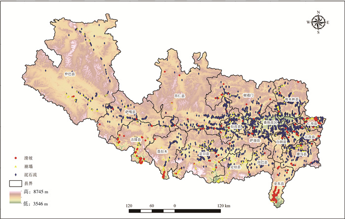
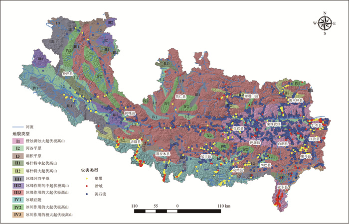
Figure 1.
Distribution of collapse, landslide and debris flow disasters in the Xigaze area
-
Figure 2.
Density contour map showing distribution of collapse, landslide and debris flow disasters in the Xigaze area
-
Figure 3.
Geomorphic zoning map in the Xigaze area
-
Figure 4.
Superimposed map of geomorphic zoning and geological hazards in the Xigaze area
-
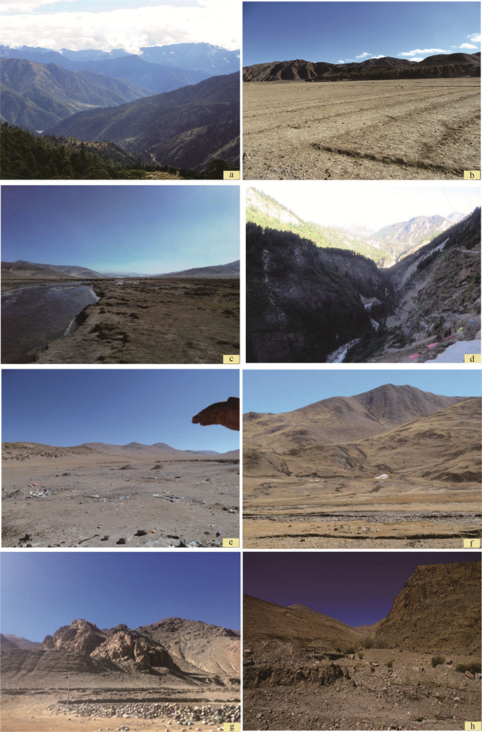
Figure 图版Ⅰ.
-
Figure 5.
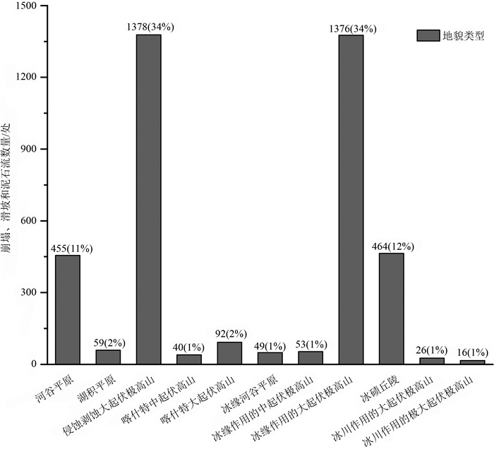
Statistical map of superposition of geological hazards and geomorphic units in the Xigaze area
-
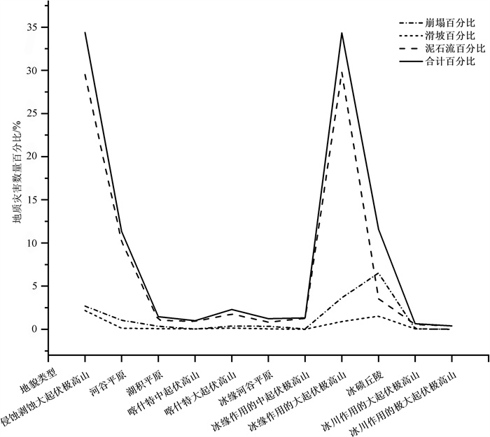
Figure 6.
Comparison of geological hazard types of each geomorphic unit in the Xigaze area
-
Figure 7.
Relationship between landslide, collapse geological hazards and slope in the Xigaze area
-
Figure 8.
Relationship between landslide, collapse geological hazards and slope direction in the Xigaze area
-
Figure 9.
Relationship between landslide, collapse geological hazards and elevation in the Xigaze city