
| Citation: |
NIU Xiaonan, NI Huan, LI Yunfeng, ZHANG Qing, ZHOU Xiaoping, LU Yuanzhi, HAO Jiaojiao. Automatic recognition method of urban underground silt based on remote sensing image—a case of Anqing City[J]. Geological Bulletin of China, 2021, 40(10): 1697-1706.

|
Automatic recognition method of urban underground silt based on remote sensing image—a case of Anqing City
-
Abstract
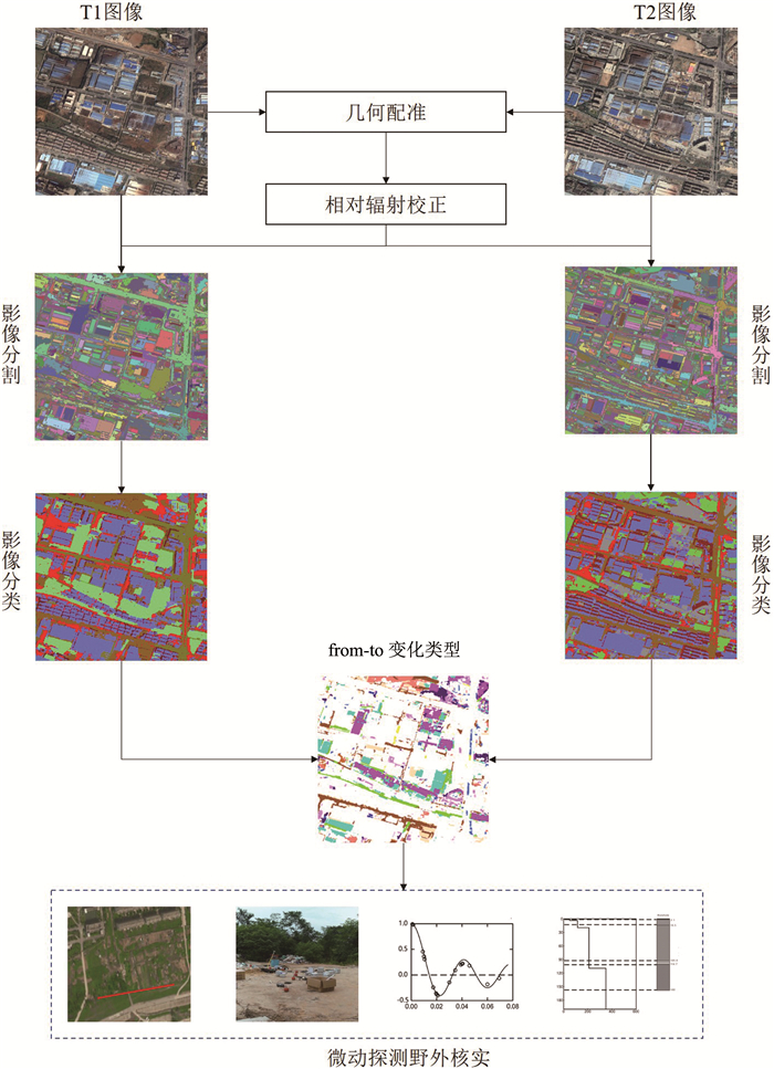
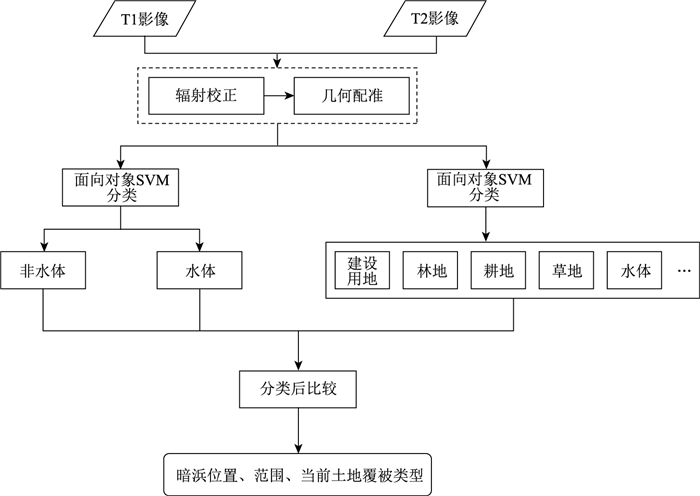
Underground silt, due to complex and loose compound, is a potential threat in urban infrastructure.Compared with the traditional methods of detecting underground silt, such as geophysical and micro-motion detection technology, remote sensing monitoring has the advantages of wide monitoring range, high efficiency and repeatability. The detection method of remote sensing image change was used to extract the spatial location and area of underground silt in urban area of Anqing. The method was mainly based on the object-oriented image analysis method, first splitting the multi-temporal images separately, and then using the SVM algorithm to classify the land cover. Based on the classification results, the spatial distribution of underground silt was extracted by change detection analysis, which could be defined as the target area or key area for the implementation of physical exploration, so as to detect the depth of the underground silt. Based on the results of two phases of image classification, change detection analysis was carried out to extract the spatial distribution and range of underground silt, and select typical areas for field verification using microtremor detection. The proposed method can provide decision support for urban engineering construction and urban planning. It can delineate the target area or key area for geophysical exploration, and improve the efficiency of geophysical exploration.
-

-
References
[1] 翟法智, 徐佩芬, 潘丽娜, 等. 宁波轨道交通暗浜勘察物探方法研究[J]. 地球物理学进展, 2017, 32(4): 1856-1861. [2] 刘军强, 翟法智, 黄明. 微动探测法在城市轨道交通暗浜勘察中的应用[J]. 铁道勘察, 2017, 43(6): 57-60. doi: 10.3969/j.issn.1672-7479.2017.06.017 [3] Singh A. Review article digital change detection techniques using remotely-sensed data[J]. International Journal of Remote Sensing, 1989, 10(6): 989-1003. doi: 10.1080/01431168908903939 [4] Hussain M, Chen D, Cheng A, et al. Change detection from remotely sensed images: From pixel-based to object-based approaches[J]. ISPRS Journal of Photogrammetry and Remote Sensing, 2013, 80(2): 91-106. [5] 李德仁. 利用遥感影像进行变化检测[J]. 武汉大学学报(信息科学版), 2003, 28(S1): 7-12. [6] 肖化超, 周诠, 张建华. 遥感卫星在轨机场变化检测方法[J]. 测绘通报, 2015, (1): 22-25. [7] 眭海刚, 冯文卿, 李文卓, 等. 多时相遥感影像变化检测方法综述[J]. 武汉大学学报(信息科学版), 2018, 43(12): 1885-1898. [8] Liu H, Yang M, Chen J, et al. Line-constrained shape feature for building change detection in VHR remote sensing imagery[J]. ISPRS International Journal of Geo-Information, 2018, 7(10): 410. doi: 10.3390/ijgi7100410 [9] Wen D, Huang X, Zhang L, et al. A novel automatic change detection method for urban high-resolution remotely sensed imagery based on multiindex scene representation[J]. IEEE Transactions on Geoscience and Remote Sensing, 2016, 54(1): 609-625. doi: 10.1109/TGRS.2015.2463075 [10] 杜培军, 白旭宇, 罗洁琼, 等. 城市遥感研究进展[J]. 南京大学学报(自然科学版), 2018, 10(1): 11-29. [11] 龙玄耀, 李培军. 基于图像分割的城市变化检测[J]. 地球信息科学, 2008, 10(1): 121-127. doi: 10.3969/j.issn.1560-8999.2008.01.020 [12] 侯恩科, 张杰, 谢晓深, 等. 无人机遥感与卫星遥感在采煤地表裂缝识别中的对比[J]. 地质通报, 2019, 38(2/3): 443-448. [13] Desclee B, Bogaert P, Defourny P. Forest change detection by statistical object-based method[J]. Remote Sensing of Environment, 2006, 102(1): 1-11. [14] Conchedda G, Durieux L, Mayaux P. An object-based method for mapping and change analysis in mangrove ecosystems[J]. ISPRS Journal of Photogrammetry and Remote Sensing, 2008, 63(5): 578-589. doi: 10.1016/j.isprsjprs.2008.04.002 [15] Duveiller G, Defourny P, Desclee B, et al. Deforestation in Central Africa: Estimates at regional, national and landscape levels by advanced processing of systematically-distributed Landsat extracts[J]. Remote Sensing of Environment, 2008, 112(5): 1969-1981. doi: 10.1016/j.rse.2007.07.026 [16] Stow D. Geographic object-based image change analysis. handbook of applied spatial analysis: software tools, methods and applications[M]. Berlin: Springer, 2010: 565-582. [17] Wang Z, Liu Y, Ren Y, et al. Object-Level double constrained method for land cover change detection[J]. Sensors, 2018, 19(1): 79. doi: 10.3390/s19010079 [18] Hansen M C, Loveland T R. A review of large area monitoring of land cover change using Landsat data[J]. Remote Sensing of Environment, 2012, 122: 66-74. doi: 10.1016/j.rse.2011.08.024 [19] Hantson S, Chuvieco E. Evaluation of different topographic correction methods for Landsat imagery[J]. International Journal of Applied Earth Observation and Geoinformation, 2011, 13(5): 691-700. doi: 10.1016/j.jag.2011.05.001 [20] Xian G, Homer C G. Updating the 2001 National Land Cover Database Impervious Surface Products to 2006 using Landsat imagery change detection methods[J]. Remote Sensing of Environment, 2010, 114(8): 1676-1686. doi: 10.1016/j.rse.2010.02.018 [21] Okada H. Theory of efficient array observations of microtremors with special reference to the SPAC method[J]. Australian Society of Exploration Geophysicists (ASEG), 2006, 37(1): 73-85. doi: 10.1071/EG06073 [22] Apostolidis P, Raptakis D, Roumelioti Z, et al. Determination of S-wave velocity structure using microtremors and spac method applied in Thessaloniki (Greece)[J]. Soil Dynamics & Earthquake Engineering, 2004, 24(1): 49-67. [23] Satoh T, Kawase H, Matsushima S. Estimation of S-Wave Velocity Structures in and around the Sendai Basin, Japan, Using Array Records of Microtremors[J]. Bulletin of the Seismological Society of America, 2001, 91(2): 206-218. doi: 10.1785/0119990148 [24] 刘铁华. 综合微动技术在昆明地铁勘探中适用性的量化研究[J]. 工程地球物理学报, 2019, 16(5): 572-579. doi: 10.3969/j.issn.1672-7940.2019.05.003 [25] 王娜. 面向对象的高分辨率遥感影像土地覆盖信息提取技术研究[D]. 昆明理工大学硕士学位论文, 2016. [26] 刘建华. 高空间分辨率遥感影像自适应分割方法研究[D]. 福州大学博士学位论文, 2011. [27] Kavzoglu T, Colkesen I. A kernel functions analysis for support vector machines for land cover classification[J]. International Journal of Applied Earth Observation & Geoinformation, 2009, 11(5): 352-359. -
Access History
Figures(8)
Tables(2)

Export File
Citation
NIU Xiaonan, NI Huan, LI Yunfeng, ZHANG Qing, ZHOU Xiaoping, LU Yuanzhi, HAO Jiaojiao. Automatic recognition method of urban underground silt based on remote sensing image—a case of Anqing City[J]. Geological Bulletin of China, 2021, 40(10): 1697-1706.
Format
Content
 DownLoad:

-
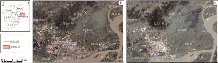
Figure 1.
Illustration of the study area and remote sensing images
-
Figure 2.
The flow chart of the method
-
Figure 3.
Technical flow chart
-
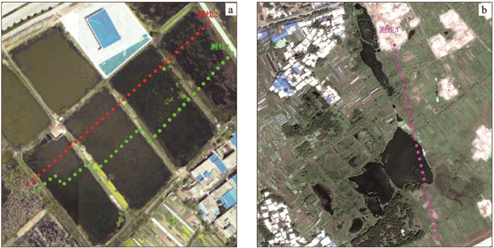
Figure 4.
Layout of microtremor survey (images of 2004)
-
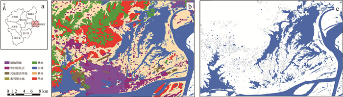
Figure 5.
The classification results of remote sensing images
-
Figure 6.
The extraction results of the underground silt
-
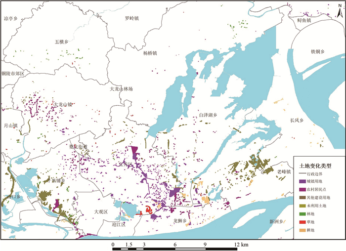
Figure 7.
Land cover types in the area of underground silt
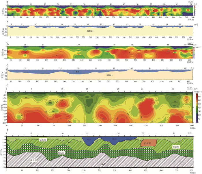
- Figure 8.