
| Institute of Geomechanics, Chinese Academy of Geological Sciences | Host |
| Citation: |
WEN Jing, WANG Da-ming, FANG Hong-bin, HU Yu-xin, XU Ning, LIN Jing-dun. THE TECHNOLOGY OF REMOTE SENSING TRIAL PROCESSING SYSTEM FOR GEOLOGICAL EXPLORATION AND ITS IMPLEMENTATION[J]. Journal of Geomechanics, 2015, 21(2): 151-162.

|
THE TECHNOLOGY OF REMOTE SENSING TRIAL PROCESSING SYSTEM FOR GEOLOGICAL EXPLORATION AND ITS IMPLEMENTATION
-
Abstract
Based on existent software and hardware environment, remote sensing trail processing system for geological exploration is designed and developed as a software platform of data receiving, data catalog storage, data processing and data application for solving the requires of detecting and surveying mineral resources and oil gas. It is able to receive and playback storage management, processing, information extraction and application for satellite-aviation-ground data. This remote sensing trail processing system for geological exploration is of extension and integration, which had achieved good effects in some filed investigations in the East Tianshan of Xinjiang and Qulong of Tibet, and the extraction of abnormal oil/gas information in Yulin of Shaanxi.
-

-
References
[1] 彭齐鸣.资源卫星在国土资源领域应用及发展建议[J].国土资源遥感, 2009, 21(1):1~2. doi: 10.6046/gtzyyg.2009.01.01 PENG Qi-ming. Application and development proposals of resource satellite in the field of land and resources[J]. Remote Sensing for Land and Resources, 2009, 21(1): 1~2. doi: 10.6046/gtzyyg.2009.01.01 [2] 杜晓, 晋佩东, 郭大海, 等.遥感影像快速入库和元数据提取系统的研究[J].国土资源遥感, 2006, 18(3):80~84. doi: 10.6046/gtzyyg.2006.03.18 DU Xiao, JIN Pei-dong, GUO Da-hai, et al. Researches on the rapid importing of remote sensing images and metadata acquiring system[J]. Remote Sensing for Land and Resources, 2006, 18(3): 80~84. doi: 10.6046/gtzyyg.2006.03.18 [3] 周伟, 黄炜, 王彦佐.资源一号02C卫星数据管理与服务系统研建[J].国土资源遥感, 2014, 26(1):179~185. doi: 10.6046/gtzyyg.2014.01.30 ZHOU Wei, HUANG Wei, WANGYan-zuo, et al. Tentative construction of satellite data management and service system for ZY-102C[J]. Remote Sensing for Land and Resources, 2014, 26(1): 179~185. doi: 10.6046/gtzyyg.2014.01.30 [4] 钟广锐.基于ArcGIS Flex API的WebGIS设计[J].测绘科学, 2012, 37(3):147~149. ZHONG Guang-rui. The design of WebGIS based on ArcGIS Flex API [J]. Science of Surveying and Mapping, 2012, 37(3): 147~149. -
Access History

Figures(18)

Export File
Citation
WEN Jing, WANG Da-ming, FANG Hong-bin, HU Yu-xin, XU Ning, LIN Jing-dun. THE TECHNOLOGY OF REMOTE SENSING TRIAL PROCESSING SYSTEM FOR GEOLOGICAL EXPLORATION AND ITS IMPLEMENTATION[J]. Journal of Geomechanics, 2015, 21(2): 151-162.
Format
Content
 DownLoad:


-
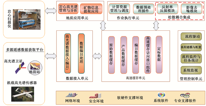
Figure 1.
The figure of system framework for remote sensing trial processing system for geological exploration
-
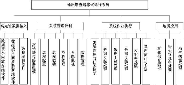
Figure 2.
System frameworks for remote sensing trial processing system for geological exploration
-
Figure 3.
Data flow and control flow of remote sensing trial processing system for geological exploration
-
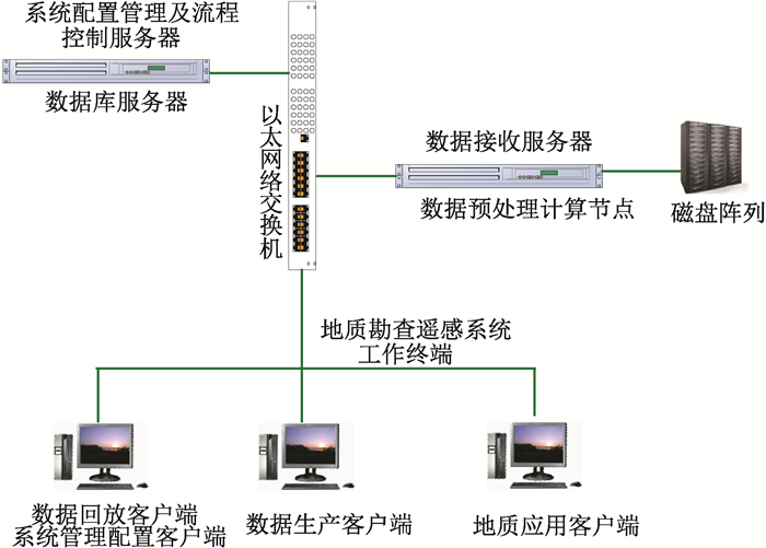
Figure 4.
Hardware plan of system
-
Figure 5.
Composition frameworks Figure of remote sensing trial processing system for geological exploration
-
Figure 6.
The interface of main control desk program
-
Figure 7.
The composition of receiving hyperspectral image unit
-
Figure 8.
Back play software of hyperspectral image
-
Figure 9.
The composition of management and domination unit
-
Figure 10.
The interface of process modeling and software
-
Figure 11.
The composition of execution unit
-
Figure 12.
The reflectance retrieval software of remote sensing trial processing system for geological exploration
-
Figure 13.
The composition of geological application unit
-
Figure 14.
The information extraction software of remote sensing trial processing system for geological exploration
-
Figure 15.
The software of extraction of abnormal oil-gas information by hyperspectral image
-
Figure 16.
The interface of core management software
-
Figure 17.
The result of spectral angle mapping by using HyMap in east Tianshan, Xinjiang
-
Figure 18.
The image of extraction of alteration information in Yulin