
| Institute of Geomechanics, Chinese Academy of Geological Sciences | Host |

| Citation: |
FENG Zhen, LI Bin, ZHAO Chao-ying, WANG Li, WANG Lei. GEOLOGICAL HAZARDS MONITORING AND APPLICATION IN MOUNTAINOUS TOWN OF THREE GORGES RESERVOIR[J]. Journal of Geomechanics, 2016, 22(3): 685-694.

|
GEOLOGICAL HAZARDS MONITORING AND APPLICATION IN MOUNTAINOUS TOWN OF THREE GORGES RESERVOIR
-
Abstract
Regular geological hazards monitoring is very difficult in southwestern mountainous area, due to steep terrain, abundant plants, rainy and foggy weather. On the basis of geological hazards survey, a comprehensive monitoring network has been established. Regular geo-hazards monitoring devices, such as telescopic displacement meters and stressometers, are installed to monitor relative displacement of ground cracks and stress in base of perilous rock respectively. Static and real-time GPS, as well as corner reflector interferometry (CR-InSAR), are applied to monitor ground movement of perilous rocks. In order to obtain regional deformation, high coherence InSAR is adopted to investigate and detect geo-hazards. The Yangjiao monitoring network achieves high-resolution and real-time monitoring, and the methods applied are essentially in agreement with movement results.
-
Keywords:
- mountainous town /
- geological hazards monitoring /
- perilous rock /
- InSAR
-

-
References
[1] 殷跃平.三峡工程库区移民迁建区地质灾害与防治[J].地质通报, 2002, 2(12):876~880. doi: 10.3969/j.issn.1671-2552.2002.12.011 YIN Yue-ping. Geohazards and their prevention in resettlement areas of emigrants from the reservoir region of the Three Gorges Project[J]. Geological Bulletin of China, 2002, 21(12):876~880. doi: 10.3969/j.issn.1671-2552.2002.12.011 [2] 殷跃平. 加强城镇化进程中的地灾防治工作[N]. 中国国土资源报, 2014-04-21(4). YIN Yue-ping. Enhance geological hazards mitigation in urbanization process[N]. China Land and Resource News, 2014-04-21(04). [3] 刘传正.重庆武隆羊角镇工程地质环境初步研究[J].水文地质工程地质学报, 2013, 40(2):1~8. LIU Chuang-zhen. Primary research on the geological environment around Yangjiao Twon in Wulong County, Chongqing, China[J]. Hydrogeology and Engineering Geology, 2013, 40(2):1~8. [4] 黄润秋.中国西部地区典型岩质滑坡机理研究[J].地球科学进展, 2004, 19(3):443~450. HUANG Run-qiu. Mechanism of large scale landslides in western China[J]. Advance in Earth Sciences, 2004, 19(3):443~450. [5] 殷跃平, 朱继良, 杨胜元.贵州关岭大寨高速远程滑坡-碎屑流研究[J].工程地质学报, 2010, 18(4):445~454. YIN Yue-ping, ZHU Ji-liang, YANG Sheng-yuan. Investigation of a high speed and long run-out rockslide-debris floe at Dazhai in Guizhou Province[J]. Journal of Engineering Geology, 2010, 18(4):445~454. [6] 殷跃平, 刘传正, 陈红旗, 等.2013年1月11日云南镇雄赵家沟特大滑坡灾害研究[J].工程地质学报, 2013, 21(1):6~15. YIN Yue-ping, LIU Chuan-zheng, CHEN Hong-qi, et al, Investigation on catastrophic landslide of January 11, 2013 at Zhaojiagou, Zhenxiong County, Yunnan Province[J]. Journal of Engineering Geology, 2013, 21(1):6~15. [7] 刘传正, 杨冰.三峡库区地质灾害调查评价与监测预警新思维[J].工程地质学报, 2001, 9(2):121~126. LIU Chuang-zhen, YANG Bing. 2001. A new method of surveying, evaluating, monitoring and forecasting for the geological hazards in the Three Gorges on Changjiang River[J]. Journal of Engineering Geology, 2001, 9(2):121~126. [8] 王磊, 李滨, 冯振, 等.武隆县羊角场镇厚层灰岩山体大型危岩体破坏模式及成因机制研究[J].地质学报, 2015, 89(2):461~471. WANG Lei, LI Bin, FENG Zhen, et al. The failure patterns and their formation mechanisms of large perilous rocks in thick layered limestone masses in Yangjiao Town, Wulong[J]. Acata Geologica Sinica, 2015, 89(2):461~471. [9] 张勤.GPS监测滑坡形变的基准研究[J].西安工程学院学报, 2001, 23(4):69~71. ZHANG Qin. The datum research of the slope deformation monitor by GPS[J]. Journal of Xi'an Engineering University, 2001, 23(4):69~71. [10] 朱建军, 邢学敏, 胡俊, 等.利用InSAR技术监测矿区地表形变[J].中国有色金属学报, 2011, 21(10):2564~2576. ZHU Jian-jun, XING Xue-ming, HU Jun, et al. Monitoring of ground surface deformation in mining area with InSAR technique[J]. Chinese Journal of Nonferrous Metals, 2011, 21(10):2564~2576. [11] 邢学敏, 朱建军, 汪长城, 等.一种新的CR点目标识别方法及其在公路形变监测中的应用[J].武汉大学学报:信息科学版, 2011, 36(6):699~703. XING Xue-ming, ZHU Jian-jun, WANG Chang-cheng, et al. A new method for CR point identification and it's application to highway deformation monitoring[J]. Geomatics and Information Science of Wuhan University, 2011, 36(6):699~703. [12] 许文斌, 李志伟, 丁晓利, 等.利用InSAR短基线技术估计洛杉矶地区的地表时序形变和含水参数[J].地球物理学报, 2012, 55(2):452~461. XU Wen-bin, LI Zhi-wei, DING Xiao-li, et al. Application of small baseline subsets D-InSAR technology to estimate the time series land deformation and aquifer storage coefficients of Los Angeles area[J]. Chinese Journal Geophysics, 2012, 55(2):452~461. -
Access History

Figures(9)
Tables(2)

Export File
Citation
FENG Zhen, LI Bin, ZHAO Chao-ying, WANG Li, WANG Lei. GEOLOGICAL HAZARDS MONITORING AND APPLICATION IN MOUNTAINOUS TOWN OF THREE GORGES RESERVOIR[J]. Journal of Geomechanics, 2016, 22(3): 685-694.
Format
Content
 DownLoad:

-
Figure 1.
Distribution of geological hazards in Yangjiao area
-
Figure 2.
Lay-out of geohazards monitoring devices in Yangjiao area
-
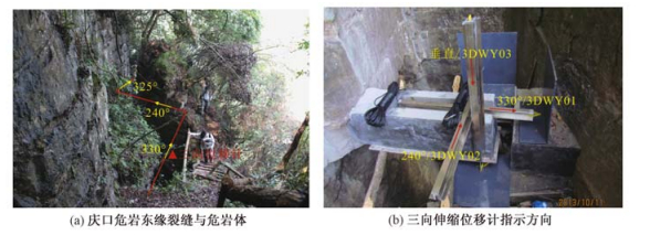
Figure 3.
The three dimensional displacement monitoring devices installed in Yangjiao area
-
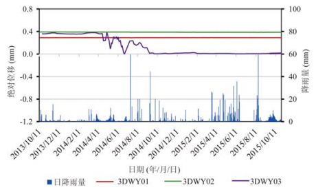
Figure 4.
Time series of relative displacement of ground cracks in Yangjiao area
-
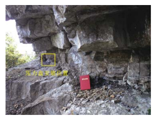
Figure 5.
Location of stress monitoring devices
-
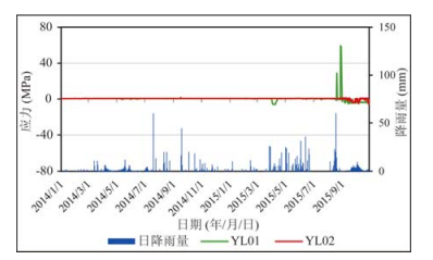
Figure 6.
Time series of stress in perilous rock base in Yangjiao area
-
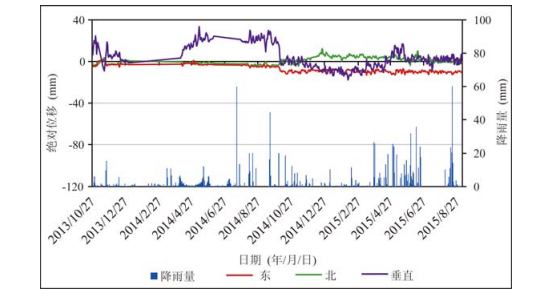
Figure 7.
Time series of deformation in DT01 station by real-time GPS monitoring
-
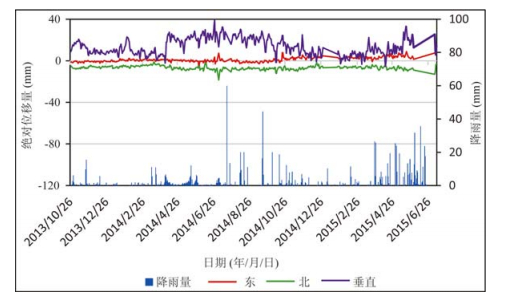
Figure 8.
Time series of deformation in DT02 station by real-time GPS monitoring
-
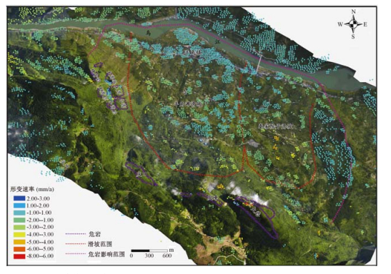
Figure 9.
Average ground deform velocity of Yangjiao area (June 2012-January 2014)