
| Institute of Geomechanics, Chinese Academy of Geological Sciences | Host |

| Citation: |
LI Jian-feng, LIU Feng, WU Zhong-hai. POSSIBLE SEISMIC CONTROL ON RIVER CHANNEL CHANGE IN THE LONGMENSHAN MOUNTAIN[J]. Journal of Geomechanics, 2016, 22(3): 659-666.

|
POSSIBLE SEISMIC CONTROL ON RIVER CHANNEL CHANGE IN THE LONGMENSHAN MOUNTAIN
-
Abstract
The 2008 Mw7.9 Wenchuan earthquake induced a large quantity of landslides whose materials entered the river channels. In some channel reach the seismic surface ruptures caused the co-seismic knick points across the channel of the Longmenshan Mountain. The river morphology and hydrodynamic condition may be changed. The field investigations show that co-seismic knick points disappeared rapidly, and meander cut-off would potentially occur in the near future. This suggests that the temporal increase in sediment input will not reduce the long-term fluvial transport capacity. A few years later, the rivers will reach a new state of eroion-transport-deposition. It is concluded that the seismic erosion events (landslide) and local hydrometerological conditions (heavy rainfall and flash flood) exert significant controls on the river channel change in the Longmenshan Mountain.
-
Keywords:
- meander cutoff /
- knick point /
- river channel change /
- large earthquake /
- Longmenshan Mountain
-

-
References
[1] Schumm S A. The fluvial system[M]. Wiley-Interscience, 1977. [2] Dai F C, Xu C, Yao X, et al. Spatial distribution of landslides triggered by the 2008Ms8.0 Wenchuan earthquake, China[J]. Journal of Asian Earth Sciences, 2011, 40(4):883~895. doi: 10.1016/j.jseaes.2010.04.010 [3] Wang E C, Meng Q R. Mesozoic and Cenozoic tectonic evolution of the Longmenshan fault belt[J]. Science in China Series D:Earth Sciences, 2009, 52(5):579~592. doi: 10.1007/s11430-009-0053-8 [4] Burchfiel B C, Chen Z L, Liu Y P, et al. Tectonics of the Longmenshan and adjacent region, central China[J]. International Geology Review, 1995, 37(8):661~735. doi: 10.1080/00206819509465424 [5] 邓起东, 陈社发, 赵小麟.龙门山及其邻区的构造和地震活动及动力学[J].地震地质, 1994, 16(4):389~403. DENG Qi-dong, CHEN She-fa, ZHAO Xiao-lin. Tectonics, seismicity and dynamics of Longmenshan Mountain and its adjacent regions[J]. Seismology and Geology, 1994, 16(4):389~403. [6] Xu X W, Wen X Z, Yu G H, et al. Coseismic reverse and oblique-slip surface faulting generated by the 2008Mw7.9 Wenchuan earthquake, China[J]. Geology, 2009, 37(6):515~518. doi: 10.1130/G25462A.1 [7] Fu B H, Shi P L, Guo H D, et al. Surface deformation related to the 2008 Wenchuan earthquake, and mountain building of the Longmen Shan, eastern Tibetan Plateau[J]. Journal of Asian Earth Sciences, 2011, 40(4):805~824. doi: 10.1016/j.jseaes.2010.11.011 [8] Qi S W, Xu Q, Lan H X, et al. Spatial distribution analysis of landslides triggered by 20085.12 Wenchuan Earthquake, China[J]. Engineering Geology, 2010, 116(1/2):95~108. [9] Parker R N, Densmore A L, Rosser N J, et al. Mass wasting triggered by the 2008 Wenchuan earthquake is greater than orogenic growth[J]. Nature Geoscience, 2011, (4):449~452. [10] 李智武, 陈洪德, 刘树根, 等.龙门山冲断隆升及其走向差异的裂变径迹证据[J].地质科学, 2010, 45(4):944~968. LI Zhi-wu, CHEN Hong-de, LIU Shu-gen, et al. Differential uplift driven by thrusting and its lateral variation along the Longmenshan belt, western Sichuan, China:Evidence from fission track thermochronology[J]. Chinese Journal of Geology, 2010, 45(4):944~968. [11] Kirby E, Whipple K X, Tang W Q, et al. Distribution of active rock uplift along the eastern margin of the Tibetan Plateau:Inferences from bedrock channel longitudinal profiles[J]. Journal of Geophysical Research, 2003, 108(B4):2217. [12] 贾营营, 付碧宏, 王岩, 等.青藏高原东缘龙门山断裂带晚新生代构造地貌生长及水系响应[J].第四纪研究, 2010, 30(4):825~836. JIA Ying-ying, FU Bi-hong, WANG Yan, et al. Late Cenozoic tectono-geomorphic growth and drainage response in the Longmen Shan fault zone, east magrin of Tibet[J]. Quaternary Sciences, 2010, 30(4):825~836. [13] 周荣军, 李勇, Densmore A L, 等.青藏高原东缘活动构造[J].矿物岩石, 2006, 26(2):40~51. ZHOU Rong-jun, LI Yong, Densmore A L, et al. Active tectonics of the eastern margin of the Tibet Plateau[J]. Journal of Mineralogy and Petrology, 2006, 26(2):40~51. [14] 何宏林, 孙昭民, 魏占玉, 等.汶川Ms8.0地震地表破裂带白沙河段破裂及其位移特征[J].地震地质, 2008, 30(3):658~672. HE Hong-lin, SUN Zhao-min, WEI Zhan-yu, et al. Rupture of the Ms8.0 Wenchuan earthquake along Baishahe River[J]. Seismology and Geology, 2008, 30(3):658~672. [15] 付碧宏, 王萍, 孔屏, 等.中国汶川"5.12"8.0级大地震:地震地质灾害图集[M].北京:地震出版社, 2009. FU Bi-hong, WANG Ping, KONG Ping, et al. The atlas of seismic geohazards of Chinese Wenchuan 5.12Ms8.0 earthquake[M]. Beijing:Seismological Press, 2009. [16] Sklar L S, Dietrich W E. Sediment and rock strength controls on river incision into bedrock[J]. Geology, 2001, 29(12):1087~1090. doi: 10.1130/0091-7613(2001)029 < 1087:SARSCO > 2.0.CO; 2 [17] Lamb M P, Dietrich W E, Sklar L S. A model for fluvial bedrock incision by impacting suspended and bed load sediment[J]. Journal of Geophysical Research, 2008, 113(F3):F03025. [18] Burbank D W. Rates of erosionand their implicationsforexhumation[J]. Mineralogical Magazine, 2002, 66(1):25~52. doi: 10.1180/0026461026610014 [19] 何仲太, 马保起, 田勤俭, 等.汶川8.0地震地表破裂平通镇段的变形特征[J].第四纪研究, 2008, 28(5):789~795. HE Zhong-tai, MA Bao-qi, TIAN Qin-jian, et al. Deformation features of surface rupture of the Wenchuan earthquake (M 8.0) at the Pingtong Town[J]. Quaternary Sciences, 2008, 28(5):789~795. [20] Howard A D. A detachment-limited model of drainage basin evolution[J]. Water Resources Research, 1994, 30(7):2261~2286. doi: 10.1029/94WR00757 [21] Miller J R. The influence of bedrock geology on knickpoint development and channel-bed degradation along downcutting streams in south-central Indiana[J]. The Journal of Geology, 1991, 99(4):591~605. doi: 10.1086/629519 [22] 杨景春, 李有利.地貌学原理(修订版)[M].北京:北京大学出版社, 2005. YANG Jing-chun, LI You-li. Principles of geomorphology[M]. Beijing:Peking University Press, 2005. [23] 单菊萍. 基于DEM的雅鲁藏布江河流地貌特征的研究[D]. 北京: 中国地质大学, 2007. SHAN Ju-ping. Research on the morphologcial features of Yarlung Zangbo river based on DEM[D]. Beijing:China Universiy of Geosciences, 2007. [24] Hartshorn K, Hovius N, Dade W B, et al. Climate-driven bedrock incision in an active mountain belt[J]. Science, 2002, 297(5589):2036~2038. doi: 10.1126/science.1075078 [25] Barbour J R. The origin and significance of sinuosity along incising bedrock rivers[D]. New York:Columbia University, 2008. [26] Stark C P, Barbour J R, Hayakawa Y S, et al. The climatic signature of incised river meanders[J]. Science, 2010, 327(5972):1497~1501. doi: 10.1126/science.1184406 [27] Tang C, Zhu J, Qi X, et al. Landslides induced by the Wenchuan earthquake and the subsequent strong rainfall event:A case study in the Beichuan area of China[J]. Engineering Geology, 2011, 122(1/2):22~33. [28] Huang R Q, Li W L. Development and distribution of geohazards triggered by the 5.12 Wenchuan Earthquake in China[J]. Science in China Series E:Technological Sciences, 2009, 52(4):810~819. doi: 10.1007/s11431-009-0117-1 [29] Tucker G E, Bras R L. Hillslope processes, drainage density, and landscape morphology[J]. Water Resources Research, 1998, 34(10):2751~2764. doi: 10.1029/98WR01474 [30] Korup O, Schlunegger F. Bedrock landsliding, river incision, and transience of geomorphic hillslope-channel coupling:Evidence from inner gorges in the Swiss Alps[J]. Journal of Geophysical Research, 2007, 112(F3):F03027. -
Access History
Figures(9)

Export File
Citation
LI Jian-feng, LIU Feng, WU Zhong-hai. POSSIBLE SEISMIC CONTROL ON RIVER CHANNEL CHANGE IN THE LONGMENSHAN MOUNTAIN[J]. Journal of Geomechanics, 2016, 22(3): 659-666.
Format
Content
 DownLoad:

-
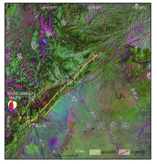
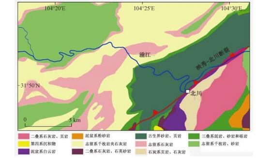
Figure 1.
Spatial distribution of the surface ruptures of the 2008 Wenchuan earthquake and the active faults in the Longmenshan Mountain
-
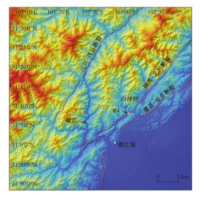
Figure 2.
The DEM of the Baisha River
-
Figure 3.
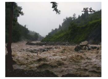
The fluvial morphology of the Beichuan reach of the Jianjiang River
-
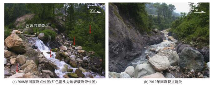
Figure 4.
The location of the co-seismic knickpoints of the Wenchuan earthquake and their rapid disappearance
-
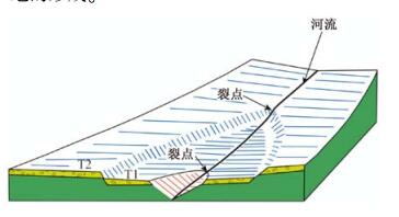
Figure 5.
Knickpoint and formation of river terrace
-
Figure 6.
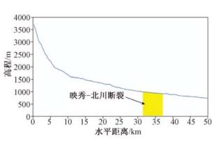
The longitudinal profile of the Baisha River
-
Figure 7.
The fluvial morphology of the Jianjiang River and the lithology
-
Figure 8.
The rapid transport capacity of the Baisha River
-
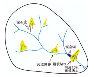
Figure 9.
Schematic representation of the geomorphological effect of the seismic landslide