
| Citation: |
YANG Yunbao, LIU Yongqing. Practice of geological mapping method in Wandashan orogenic belt of Heilongjiang Province and its significance[J]. Geological Bulletin of China, 2017, 36(11): 1919-1926.

|
Practice of geological mapping method in Wandashan orogenic belt of Heilongjiang Province and its significance
-
Abstract
The Wandashan accetionary orogenic belt (also called Nadanhada terrane), is located on the continental margin of Northeast Asia. It is connected with the Sikhote-Alin orogenic belt in Far East of Russia, which together constitute a great proportion of circum-Pacific orogenic zone. These orogenic belts were closely related to the paleo-Pacific Ocean subduction. So far the research has suggested that these orogenic belts consist of such complex geological blocks as exotic terrain, small continent, island arc, oceanic crust, seamount, oceanic plateau and ophiolite. Nevertheless, the traditional rock-stratigraphy geological mapping method is not suitable for the study area and it can not reflect the composition and tectonic properties of the complex. Therefore, this geological mapping practice was aimed at the complex structural area of the orogenic belt and, based on the traditional field geological survey method, the authors used the non-Smith stratigraphic mapping method to carry out the systematic geological mapping work. The results obtained by the authors should be significant for the understanding of tectonic evolution of Wandashan orogenic belt and also will play an exemplary role for orogenic belt mapping.
-
Keywords:
- Wandashan /
- orogenic belt mapping /
- non-Smith stratum
-

-
References
[1] 程瑞玉, 吴福元, 孙德有, 等.黑龙江省东部饶河杂岩的就位时代与东北东部中生代构造演化[J].岩石学报, 2006, 22(2):353-376. [2] 康宝祥, 张海驲, 刘春山, 等.那丹哈达岭饶河蛇绿岩及其地质意义[J].黑龙江地质, 1990, 1(1):3-18. [3] 李继亮.增生型造山带的基本特征[J].地质通报, 2004, 23(9):947-951. [4] 张国宾. 黑龙江东部完达山地块区域成矿系统研究[D]. 吉林大学, 2014. http://cdmd.cnki.com.cn/article/cdmd-10183-1015513581.htm [5] 邵济安, 王成源, 唐克东.乌苏里地区构造新探索[J].地质论评, 1992, 38(1):33-39. [6] 水谷伸治郎, 邵济安, 张庆龙.那丹哈达地体与东亚大陆边缘中生代构造的关系[J].地质学报, 1989, 63(3):204-216. [7] 任收麦, 朱日祥, 邱海峻, 等.黑龙江省饶河枕状玄武岩古地磁学研究及其构造意义[J].地球物理学报, 2015, 58(4):1269-1283. doi: 10.6038/cjg20150415 [8] 张传恒, 张世红.完达山造山带原型盆地及可能的造山机制[J].现代地质, 1999, 13(1):25-31. [9] 张海驲, 刘荣芝, 张书范, 等.黑龙江省完达山早中生代深海沉积地层[J].黑龙江地质, 1991, 2(2):30-40. [10] 张世红, 施央申, 孙岩, 等.黑龙江完达山造山带及其那丹哈达地体的关系[J].南京大学学报(地球科学), 1991, 3:287-294. [11] 于健, 郭巍, 王少华, 等.饶河地区大岭桥组沉积环境恢复及其地质意义[J].世界地质, 2015, 34(1):113-119. [12] 杨金中.跃进山岩系及其构造意义[J].长春科技大学学报, 1998, 28(4):380-385. [13] 田东江. 完达山造山带的地质-地球化学组成及其演化[D]. 吉林大学地球科学学院硕士学位论文, 2007. [14] 黑龙江省地质矿产局.黑龙江省地质志[M].北京:地质出版社, 1993. [15] 邵济安, 王成源, 唐克东, 等.那丹哈达岭地层与地体的关系[J].地层学杂志, 1990, 14(4):286-291. [16] 赵海玲, 邓晋福, 陈发景, 等.黑龙江完达山地区中侏罗世火山岩特征及其形成构造背景[J].地球科学:中国地质大学学报, 1996, 21(4):428-432. [17] 赵武峰, 郭亚军.完达山地区中三叠世-早侏罗世放射虫组合[J].黑龙江地质, 1995, 6(2):13-16. [18] 周丽云, 王瑜, 王娜.中国东北完达山地区早白垩世同构造岩浆侵位——对晚中生代左行走滑作用的响应[J].地质通报, 2015, 34(2/3):400-418. [19] 田东江, 周建波, 郑常青, 等.完达山造山带蛇绿混杂岩中变质基性岩的地球化学特征及其地质意义[J].矿物岩石, 2006, 26(3):64-70. ① 黑龙江省地质矿产局. 黑龙江省东北部完达山地区早中生代地质特征研究报告. 1987. ② 黑龙江省地质矿产局. 中华人民共和国区域地质调查报告—小佳河公社幅、饶河县幅. 1987. -
Access History
Figures(5)
Tables(2)

Export File
Citation
YANG Yunbao, LIU Yongqing. Practice of geological mapping method in Wandashan orogenic belt of Heilongjiang Province and its significance[J]. Geological Bulletin of China, 2017, 36(11): 1919-1926.
Format
Content
 DownLoad:

-
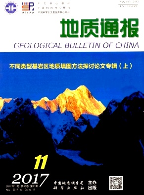
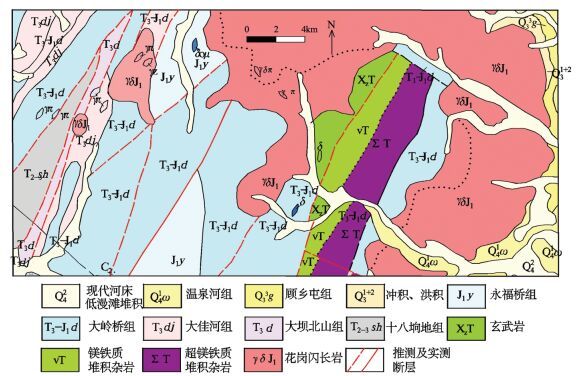
Figure 1.
Geological map of the Wandashan metallogenic area
-
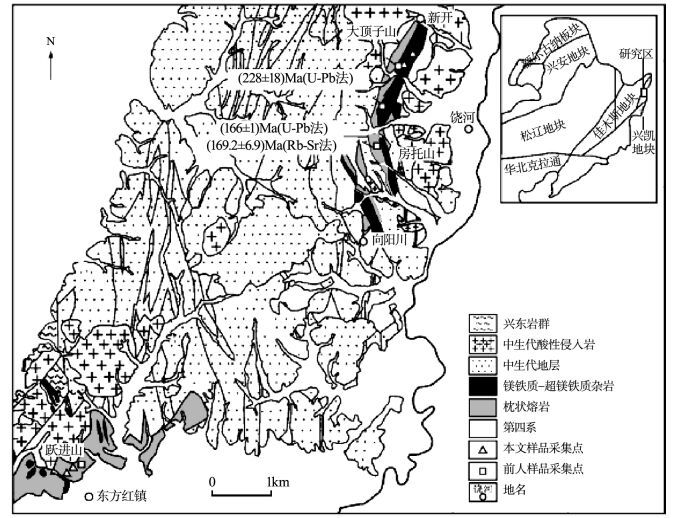
Figure 图版Ⅰ.
-
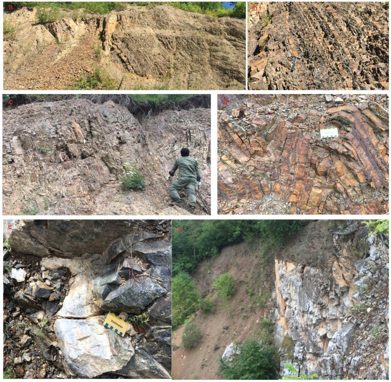
Figure 2.
Practical material map of the study area (sketch map)
-
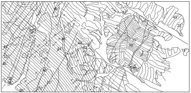
Figure 3.
Geological map of the study area
-
Figure 4.
Geological map of the study area