
| Citation: |
LI Weike, WANG Xiaolin, LIU Bing, SONG Donghu, LU Xiaoping, ZHAO Yi. New progress in the study of Gongyanghe Group in southern Baoshan block, western Yunnan Province[J]. Geological Bulletin of China, 2018, 37(11): 1970-1979.

|
New progress in the study of Gongyanghe Group in southern Baoshan block, western Yunnan Province
-
Abstract
Located at the northern end of the Yunnan-Myanmar-Malaysia-Thailand microcontinent, the Baoshan block is an important part of multi-island ocean in Paleozoic Tethys, western Yunnan Province. The oldest exposed stratum is known as the Gongyanghe Group on the Baoshan block. It is mainly exposed in two areas, i.e., Jiufang-Jiucheng-Dawangtang and Zhen'anjie-Raolangjie-Gongyanghe-Manhai-Ruili. It is a lithological association with huge thickness, consisting of sandstone, feldspar quartz sandstone, sandy slate and muddy slate, intercalated with siliceous rocks, argillaceous siliceous rocks, thin limestone, with the typical turbidity sedimentary characteristics and some low grade metamorphic features. Few fossils exist in the Gongyanghe Group, causing the lack of the chronological information, and hence its geological time was previously inferred to be Sinian to Middle Cambrian. In recent years, 1:250000 and 1:50000 regional geological survey conducted further research on Gongyanghe Group. A number of reliable LA-ICP-MS zircon U-Pb ages (925.0±9.2~500.0±1.0Ma) were obtained from newly discovered intermediate-acid volcanic lava and tuff interlayer. Combined with the differences of lithological association and sedimentary environment, it is suggested that Gongyanghe Group should be subdivided into 3 formations from bottom to top, namely Qingbaikou to Nanhua System Dawangtang Formation, Sinian-Middle Cambrian Gongyanghe Formation, and Early Cambrian-Ordovician Pumanshao Formation. This paper mainly describes the distribution, lithological association, sedimentary environment and geological epoch of the Dawangtang Formation.
-
Keywords:
- Baoshan block /
- Gongyanghe Group /
- Dawangtang Formation /
- zircon U-Pb ages
-

-
References
[1] 云南省地质矿产局.云南省岩石地层[M].武汉:中国地质大学出版社, 1996. [2] 云南省地质矿产局.云南省区域地质志[M].北京:地质出版社, 1990. [3] 杨学俊, 贾小川, 熊昌利, 等.滇西高黎贡山南段公养河群变质基性火山岩LA-ICP-MS锆石U-Pb年龄及地质意义[J].地质通报, 2012, 31(2/3):264-276. [4] 黄柏鑫.云南龙陵地区公养河群时代及沉积环境讨论[D].成都理工大学大学硕士学位论文, 2014: 1-56. http://cdmd.cnki.com.cn/article/cdmd-10616-1015535269.htm [5] 尹福光, 张虎, 黄勇, 等.泛亚铁路滇西大理至瑞丽段基础地质综合调查进展[J].地质通报, 2012, 31(2/3):218-226. [6] 刘桂春, 孙载波, 曾文涛, 等.滇西双江县勐库地区湾河蛇绿混杂岩的厘定、地球化学特征及其地质意义[J].岩石矿物学杂志, 2017, 36(2):163-174. doi: 10.3969/j.issn.1000-6524.2017.02.003 [7] 李静, 孙载波, 徐桂香, 等.滇西双江县勐库地区榴闪岩的发现与厘定[J].矿物学报, 2015, 35(4):421-424. [8] 李静, 孙载波, 黄亮, 等.滇西勐库退变质榴辉岩的P-T-t轨迹及地质意义[J].岩石学报, 2017, 33(7):2285-2291. [9] 徐桂香, 曾文涛, 孙载波, 等.滇西双江县勐库地区(退变质)榴辉岩的岩石学、矿物学特征[J].地质通报, 2016, 35(7):1036-1045. [10] 陈光艳, 徐桂香, 孙载波, 等.滇西双江县勐库地区退变质榴辉岩中闪石类矿物的成因研究[J].岩石矿物学杂志, 2017, 36(1):36-47. doi: 10.3969/j.issn.1000-6524.2017.01.003 [11] 孙载波, 李静, 周坤, 等.滇西双江县勐库地区退变质榴辉岩的岩石地球化学特征及其地质意义[J].岩石矿物学杂志, 2017, 31(4):746-756. ① 云南省地质局. 1: 20万潞西幅、瑞丽幅、弄岛幅区域地质调查报告, 1982. ② 云南省地矿局区域地质调查队三分队. 1: 20万凤庆幅区域地质调查报告, 1981. ③ 云南省地质局. 1: 20万腾冲幅区域地质调查报告, 1979. ④ 云南省地质矿产局. 1: 5万畹町镇幅区域地质调查报告, 1995. ⑤ 云南省地质矿产局. 1: 5万酒房幅幅区域地质调查报告, 2000. ⑥ 云南省地质调查院. 1: 25万凤庆幅区域地质调查报告, 2008. ⑦ 云南省地质调查院. 1: 25万腾冲县幅(国内部分)、潞西市幅(国内部分)区域地质调查报告, 2006. ⑧ 四川省地质调查院. 1: 5万清河街幅、镇安街幅、龙陵县幅、龙新福区域地质调查, 2012. ⑨ 云南省地质调查院.云南省镇康县芦子园勘查区乌木寨、玉明珠、勐捧、尖山、勐稳、罗胡山幅区域地质矿产调, 2016. ⑩ 云南省地质调查院.云南省1: 5万曼彦幅、章凤街幅、户那街幅、遮放幅、曼海幅区域地质调查, 2017. -
Access History
Figures(6)
Tables(2)

Export File
Citation
LI Weike, WANG Xiaolin, LIU Bing, SONG Donghu, LU Xiaoping, ZHAO Yi. New progress in the study of Gongyanghe Group in southern Baoshan block, western Yunnan Province[J]. Geological Bulletin of China, 2018, 37(11): 1970-1979.
Format
Content
 DownLoad:


-
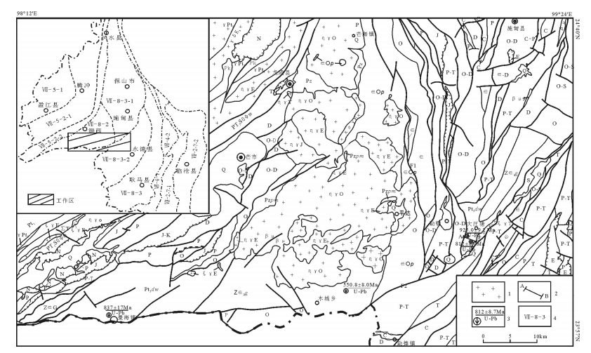
Figure 1.
Geological sketch map of the study area
-
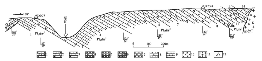
Figure 2.
Measured profile of Dawangtagn Formation at Dashan Village, Longling County, Yunnan Province
-
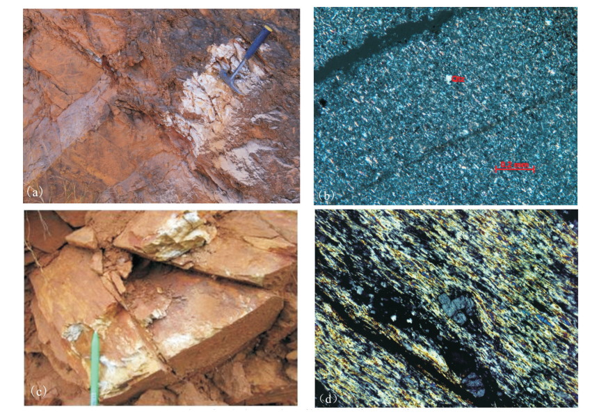
Figure 3.
Outcrop(a, c)and microphotograph(b, d)characteristics of tuff and rhyolite in the Dawangtagn Formation
-
Figure 4.
CL images of zircons (a) and zircon U-Pb data (b) in the tuff from Dawangtagn
-
Figure 5.
CL images (a) and U-Pb data (b) of zircons in the rhyolite from Dawangtagn
-
Figure 6.
CL images (a) and U-Pb data (b) of zircons in the tuff from Manhai