
| Citation: |
HE Jing, ZHENG Guisen, ZHOU Yuanxin, WANG Jiming, LIU Yu, LI Chao, LIU Liyan, HE Hanhan. Research and application of detection methods for urban underground space resources[J]. Geological Bulletin of China, 2019, 38(9): 1571-1580.

|
Research and application of detection methods for urban underground space resources
-
Abstract
The pre-exploration is the basic premise of scientific exploitation and utilization of underground space resources. Although significant investigation and evaluation have been carried out in many large cities in China, there is no published systematic summarization of exploration. On the basis of investigation and evaluation of urban underground space in Beijing, this paper describes both detection objects and methods for underground space resources in built-up areas and places to be built respectively, which represent two key steps of underground space utilization. In built-up areas in Beijing, underground space is calculated by affected depth of buildings in the vertical direction with the application of various geophysical prospecting methods, including electrical method, magnetic method, gravity detection and seismic techniques, which can define exploited underground space accurately. On the other hand, geological conditions which are likely to have impact on underground space development become the major research objects in areas to be built. In addition, a practical example is summarized to explain the concrete operation, with the expectation of providing references for related work of urban underground space resources.
-

-
References
[1] 北京市地质矿产局.北京市区域地质志[M].北京:地质出版社, 1991. [2] 李华章.北京地区第四纪古地理研究[M].北京:地质出版社, 1995:1-152. [3] 鲍亦冈, 刘振锋, 王世发, 等.北京地质百年研究[M].北京:地质出版社, 2001:1-100. [4] 童林旭, 祝文君.城市地下空间资源评估与开发利用规划[M].北京:中国建筑工业出版社, 2009. [5] Clayton C R I, Heymann G. The Stiffness of Geomaterials at Very Small Strains[J]. Geotechnique, 2001, 51(3):245-256. doi: 10.1680/geot.2001.51.3.245 [6] 陈文杰. SKUA基岩三维地质建模[J].城市地质, 2015, 10(2):72-78. doi: 10.3969/j.issn.1007-1903.2015.02.016 [7] 王瑶, 张像源, 陈文杰, 等.虚拟钻孔在深层三维地质建模中的应用[J].城市地质, 2017, 12(2):118-122. doi: 10.3969/j.issn.1007-1903.2017.02.024 [8] 王琦, 谢啸宇, 王颖珂.基于MAPGIS K9某地区三维建模的应用[J].智能城市, 2016, 2(5):101. [9] 王瑶.基于MapGis K9平台的天津市北部山区三维地质建模研究与应用[D].中国地质大学(北京)硕士学位论文, 2017. http://cdmd.cnki.com.cn/Article/CDMD-11415-1017129808.htm [10] 杨洋, 潘懋, 吴耕宇, 等.一种新的轮廓线三维地质表面重建方法[J].地球信息科学学报, 2015, 17(3):253-259. [11] 刘振, 吴耕宇, 杨博, 等.基于Creatar XModeling的地应力场模拟自动化系统研究[J].科学技术与工程, 2017, 17(15):19-25. doi: 10.3969/j.issn.1671-1815.2017.15.003 [12] 孙长军.北京地铁近接施工安全风险控制技术及应用研究[D].北京交通大学博士学位论文, 2017. http://cdmd.cnki.com.cn/Article/CDMD-10004-1017058656.htm [13] 张磊, 张晓亮, 白凌燕, 等.北京地区黄庄-高丽营断裂北段活动性研究与灾害效应分析[J].地质力学学报, 2017, 23(4):548-557. doi: 10.3969/j.issn.1006-6616.2017.04.006 [14] 刘运明.区域沉降对城市轨道交通建设的影响及应对措施[J].测绘与空间地理信息, 2016, 39(1):187-189. doi: 10.3969/j.issn.1672-5867.2016.01.063 [15] 张忠兴.城市地下资源开发的相互影响及其系统动力学研究[D].南京大学硕士学位论文, 2012. http://cdmd.cnki.com.cn/Article/CDMD-10284-1014451390.htm [16] 马行东, 梅稚平.西南某电站深埋长大洞室有毒有害气体成因分析及处理探讨[J].水电站设计, 2016, 32(3):62-64. doi: 10.3969/j.issn.1003-9805.2016.03.016 [17] 茅奇辉, 蔡守志, 薛美芸.杭州地铁1号线彭建区间地下有害气体排放试验研究[J].西部探矿工程, 2017, 29(3):177-180. doi: 10.3969/j.issn.1004-5716.2017.03.055 [18] 朱海波.渗流对地下室基坑沉降的影响及预防[J].工程建设与设计, 2017, (16):28-29. [19] 于春杰.建筑工程地下室渗漏的监理控制浅析[J].建设监理, 2017, (5):53-56. doi: 10.3969/j.issn.1007-4104.2017.05.017 [20] 李春平, 张蔚蓉.由某工程事故谈地下室抗浮问题[J].建筑结构, 2014, 44(8):44-47. [21] 盛越.地铁隧道跨逆断层支护结构抗错动影响分级评价研究[D].西南交通大学硕士学位论文, 2016. http://cdmd.cnki.com.cn/Article/CDMD-10613-1016177060.htm [22] 蔡向民, 何静, 白凌燕, 等.北京市地下空间资源开发利用规划的地质问题[J].地下空间与工程学报, 2010, 12:1105-1111. [23] 马小明, 康逊.埋地管道不均匀沉降的应力及影响因素分析[J].重庆大学学报, 2017, 40(8):45-52. [24] 张晓亮, 方同明, 韩毅, 王泽龙.关于北京市平原区测氡定位隐伏活动断裂的探讨[J].城市地质, 2013, 8(1):13-17. doi: 10.3969/j.issn.1007-1903.2013.01.003 [25] 孙淑兰.汞的来源、特性、用途及对环境的污染和对人类健康的危害[J].上海计量测试, 2006, (5):6-9. doi: 10.3969/j.issn.1673-2235.2006.05.002 [26] 中华人民共和国住房和城乡建设部.建筑桩基技术规范(JGJ94-2008)[S].北京: 中国建筑工业出版社, 2008. [27] 中华人民共和国住房和城乡建设部.建筑地基处理技术规范(JGJ79-2012)[S].北京: 中国建筑工业出版社, 2013. [28] 周圆心, 何静, 徐旸.基于遥感影像的城市地下空间资源量估算方法[J].城市地质, 2017, 12(3):87-90. doi: 10.3969/j.issn.1007-1903.2017.03.017 [29] 李世峰, 金瞰昆, 周俊杰.资源与工程地球物理勘探[M].北京:化学工业出版社.2007. [30] 石晓冬.北京城市地下空间开发利用的历程与未来[J].地下空间与工程学报, 2006, 2(7):1088-1092. -
Access History
Figures(10)
Tables(3)

Export File
Citation
HE Jing, ZHENG Guisen, ZHOU Yuanxin, WANG Jiming, LIU Yu, LI Chao, LIU Liyan, HE Hanhan. Research and application of detection methods for urban underground space resources[J]. Geological Bulletin of China, 2019, 38(9): 1571-1580.
Format
Content
 DownLoad:


-
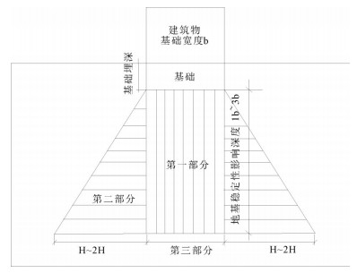
Figure 1.
The influence of building foundation on civil air defence project
-
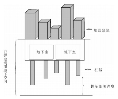
Figure 2.
Sketch map of developed space
-
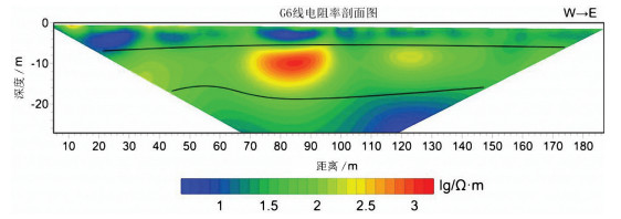
Figure 3.
Interpretation of high density resistivity
-
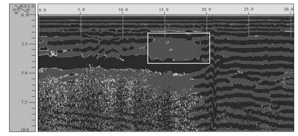
Figure 4.
Interpretation of ground penetrating radar
-
Figure 5.
Interpretation of shallow seismic survey
-
Figure 6.
Interpretation diagram of high-precision micro-gravity exploration
-
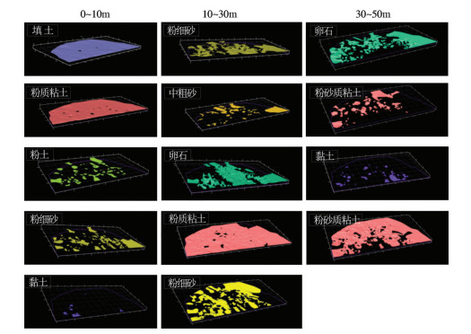
Figure 7.
Stratigraphic distribution in underground space in build-up district of the research area
-
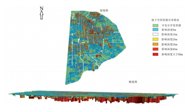
Figure 8.
Present situation of developed underground space in build-up district of the research area
-
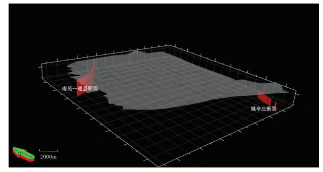
Figure 9.
Spacial distribution of active faults in building district of Beijing
-
Figure 10.
Three-dimensional model (100m underground) of building district of Beijing