
| Citation: |
HE Wenna, ZHU Changqing, LI Yangchun, CHEN Yuanyuan, WANG Yongzhi, JIANG Zuorui. An intelligent generalization method of geological body for MapGIS geological map downsizing[J]. Geological Bulletin of China, 2020, 39(6): 871-879.

|
An intelligent generalization method of geological body for MapGIS geological map downsizing
-
Abstract
Some complex problems have to be faced during medium-small scale map making from large scale geological map, such as low efficiency to merge massive geological polygons, complicated processing procedures, and being difficult in assuring data quality.This paper proposes a novel intelligent generalization method for geological body based on cartographic and artificial intelligence.Dissolving, spatial aggregation, customized fusion, elimination and exaggeration are employed to perform intelligent processing integrating map generalization and intelligent algorithms.iMapower(MapGIS version)implements the above generalization methods in corresponding modules, which can run automatically or in the form of human-computer interaction.It is very easy to complete most of complete geological body mapping tasks just clicking one time.Using real data to verify the proposed method is effective and can be corrected during mapping from large-scale map to small-scale map, and it can save at least 85 percent of geologic body generalization workload.It can greatly improve the work efficiency and assure the data quality.Furthermore, this way can play an important role in pursuing intelligent compilation of geological map.
-

-
References
[1] 李廷栋, 丁伟翠, 郑宁, 等.博览群图提升地质制图的科学技术水平[J].地球信息科学学报, 2011, 13(6):711-719, 726. [2] 李廷栋.国际地质编图现状及发展趋势[J].中国地质, 2007, 34(2):206-211 doi: 10.3969/j.issn.1000-3657.2007.02.002 [3] 王梁, 丁孝忠, 韩坤英, 等.月球数字地质图的编制与研究[J].中国地质, 2015, 42(1):331-341. doi: 10.3969/j.issn.1000-3657.2015.01.027 [4] 张士红.基于GIS与面向应用的地质编图方法探讨[J].甘肃科技, 2012, 26(6):31-33. [5] 李廷栋.中国地质编图的先驱-黄汲清先生[J].地质论评, 2004, 50(3):240-242. doi: 10.3321/j.issn:0371-5736.2004.03.005 [6] 王忠蕾, 张训华, 温珍河, 等.地质编图研究现状及发展方向[J].海洋地质前沿, 2012, 28(1):21-29. [7] 韩坤英, 丁孝忠, 范本贤, 等.基于GIS的区域地质编图方法[J].中国地质, 2005, 32(4):713-717. doi: 10.3969/j.issn.1000-3657.2005.04.022 [8] Smirnoff A, Huot-Vezina G, Paradis S J, et al.Generalizing geological maps with the GeoScaler software-The case study approach[J].Computers & Geosciences, 2012, 40:66-86. [9] 钱大刚, 高禹邦, 田世璋.1:1万缩编更新1:5万地形图作业新方法[J].测绘通报, 1998, 3:25-27 [10] 毕强, 崔利, 段建刚, 等.基于ArcGIS的土地利用现状图缩编方法研究[J].测绘通报, 2011, 3:78-81. [11] 赵正坤.基于ArcGIS的1: 100万土地利用现状图缩编技术研究——以新疆维吾尔自治区为例[D].新疆大学硕士学位论文, 2016. [12] 答星, 吴克友, 单静, 等.地形图缩编技术在地质调查底图生产中的应用[J].城市勘测, 2013, 5:19-22 doi: 10.3969/j.issn.1672-8262.2013.05.005 [13] 方晓.地质专家系统知识获取技术研究[D].北京交通大学硕士学位论文, 2009. [14] 何文娜.智绘地质——一种基于MapGIS的地质编图智能化系统[J].地球物理学进展, 2019, 34(5):2030-2036. [15] 王杨刚, 郝丽荣, 黄辉, 等.基于空间数据和专家知识驱动的地质编图技术研究与应用[J].地质通报, 2019, 38(12):2067-2076. [16] 王杨刚.基于数据驱动的基础地质图件更新关键技术研究[D].中国地质大学(北京)博士学位论文, 2016. [17] 王永志, 金樑, 朱月琴, 等.基于大数据技术的地学文档关键词提取算法研发[J].地球物理学进展, 2018, 33(3):850-859. [18] 何文娜, 朱长青, 李钟山, 等.基于地质云的我国战略性矿产资源储备信息管理平台构建[J].地球物理学进展, 2019, 34(4):1614-1620. [19] 王立生.基于人工蜂群算法的自动制图综合研究[D].兰州大学硕士学位论文, 2017. [20] 贾小斌.地图综合的智能体技术——以土地利用图斑综合为例[J].测绘学报, 2015, 44(11):1296. doi: 10.11947/j.AGCS.2015.20150245 [21] 武芳, 巩现勇, 杜佳威.地图制图综合回顾与前望[J].测绘学报, 2017, 46(10):1645-1664. doi: 10.11947/j.AGCS.2017.20170287 [22] 游晋卿, 李大军, 邹胜武.地图缩编中小图斑综合问题研究[J].安徽农业科学, 2015, 43(5):354-356, 376. doi: 10.3969/j.issn.0517-6611.2015.05.128 [23] 谢爱萍.ArcGIS制图综合在土地利用现状图缩编的方法研究[J].矿山测量, 2015, 1:26-29, 34. [24] 刘立国, 薛红琳, 姚新春.浅谈借助ArcGIS软件进行土地利用现状图缩编的方法[J].测绘通报, 2011, 9:62-65. [25] 何文娜, 朱长青, 李仰春, 等.基于ArcGIS的智能地质图综合[J].地球物理学进展, 2020, 35(2):728-734. [26] 邹胜武, 邹时林, 李大军, 等.土地利用图缩编中小图斑综合方法的改进[J].地理空间信息, 2013, 11(1):138-140. doi: 10.3969/j.issn.1672-4623.2013.01.047 [27] 庞健峰, 丁孝忠, 韩坤英, 等.1:100万中华人民共和国数字地质图空间数据库[J].中国地质, 2017, 44(S1):8-18. -
Access History
Figures(11)
Tables(1)

Export File
Citation
HE Wenna, ZHU Changqing, LI Yangchun, CHEN Yuanyuan, WANG Yongzhi, JIANG Zuorui. An intelligent generalization method of geological body for MapGIS geological map downsizing[J]. Geological Bulletin of China, 2020, 39(6): 871-879.
Format
Content
 DownLoad:
-
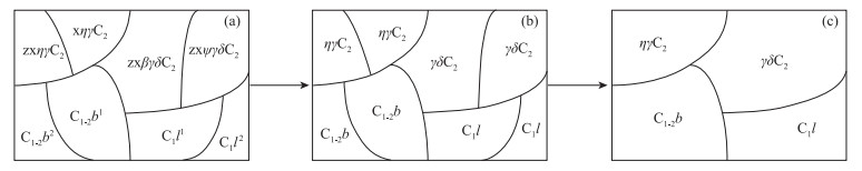
Figure 1.
Fundamental principle diagram of the same property merging
-
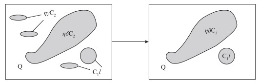
Figure 2.
Fundamental diagram of removing small contained geological bodies
-
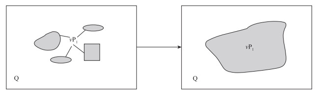
Figure 3.
The method for small geological bodies merged into adjacent big one
-
Figure 4.
Convex hull result of some small important geological bodies
-
Figure 5.
Merging some small geological bodies by customized polygon
-
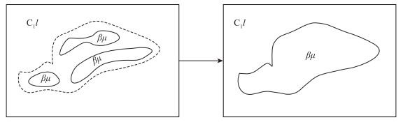
Figure 6.
The dissolving method for irregular complex geological bodies
-
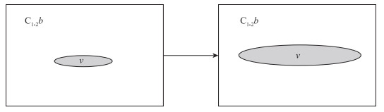
Figure 7.
Exaggeration of small geological body
-
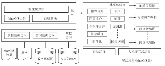
Figure 8.
Framework of intelligent generalization of geological body
-
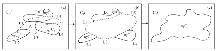
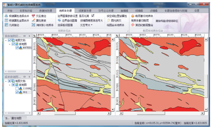
Figure 9.
Dissolving result of geological bodies
-
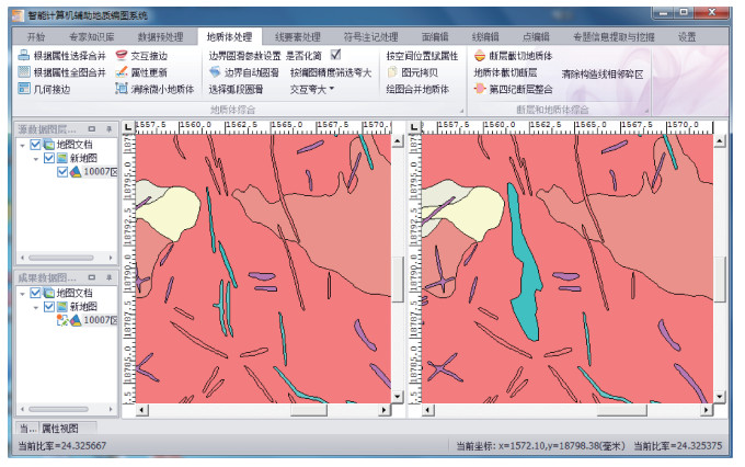
Figure 10.
Fusing some small geological bodies by customized polygon
-
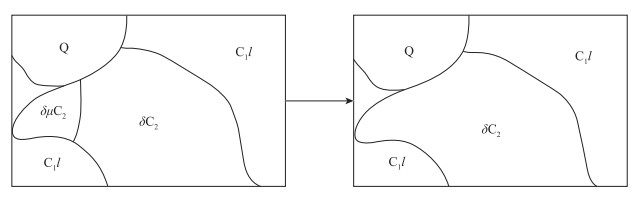
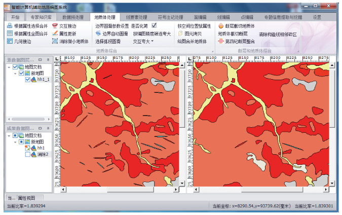
Figure 11.
Elimination of simple contained small geological bodies