
| Citation: |
LU Kai, CHU Hongxian, SUN Jun, LI Panfeng, ZHAO Tiehu, YU Yiyong, MEI Sai, FENG Jing, FANG Zhonghua. Research progress of marine geological survey of the Bohai Strait[J]. Geological Bulletin of China, 2021, 40(2-3): 287-297.

|
Research progress of marine geological survey of the Bohai Strait
-
Abstract
The high-resolution profile survey of shallow strata, high-resolution multi-channel seismic survey of small track distance, side scan sonar, surface geological sampling, drilling and other survey mean resulted in revealing of the basic geological features, including seabed topography and landform, type and distribution of the seabed, stratigraphic structure, active faults, seismicity and stress in the trans-sea passage area of the Bohai Strait, summary of the geological hazards, the Quaternary stratigraphic framework and the evolution of palaeo-environment, and description of the main achievements of crustal stability evaluation in this area.The Bohai Strait is characterized by well-developed active faults, active neotectonic movement and unstable crust.The crust stability in the eastern part of the northern Yellow Sea Basin is relatively good, while that in the western part of the Bohai Basin and the southern part of the strait area is relatively poor.The latest survey results in the Bohai Strait can provide basic data and decision-making basis for the construction of cross-sea passage projects, serve for disaster prevention and mitigation of major national sea-related engineering, and promote the understanding of the evolution of paleoclimate and environment in the Bohai Sea area.
-
Keywords:
- Bohai Strait /
- trans-straitspassage /
- stratigraphic structure /
- active faults /
- crustal stability
-

-
References
[1] 中国科学院海洋研究所海洋地质研究室. 渤海地质[M]. 北京: 科学出版社, 1985: 1-233. [2] 陈义兰, 吴永亭, 刘晓瑜, 等. 渤海海底地形特征[J]. 海洋科学进展, 2013, 3101: 75-82. doi: 10.3969/j.issn.1671-6647.2013.01.009 [3] 侯方辉, 王保军, 孙建伟, 等. 渤海海峡跨海通道新构造运动特征及其工程地质意义[J]. 海洋地质前沿, 2016, 32(5): 25-30. [4] 史慧杰, 赵铁虎, 褚宏宪, 等. 海域高分辨率24道地震采集技术在渤海海峡跨海通道项目中的应用[J]. 海洋地质前沿, 2015, 31(10): 47-56. [5] 赵铁虎, 齐君, 梅赛, 等. 渤海海峡跨海通道地质条件调查与分析[J]. 科技导报, 2016, 34(21): 39-47. [6] 陈晓辉, 张训华, 李日辉, 等. 渤海海峡海域灾害地质研究[J]. 海洋地质与第四纪地质, 2014, 1: 11-19. [7] 应绍奋, 沈永坚, 郭良迁. 渤海沿岸地区的现代构造运动[J]. 中国地震, 1986, (1): 35-41. [8] 李洪奎, 杨永波, 耿科, 等. 华北陆块区渤海陆块山东部分的厘定及其地质意义[J]. 地质调查与研究, 2013, 36(3): 173-180, 204. doi: 10.3969/j.issn.1672-4135.2013.03.002 [9] 刘忠亚, 彭轩明, 赵铁虎, 等. 渤海海峡及邻区活动断裂分布及其活动特征[J]. 海洋地质与第四纪地质, 2016, (1): 87-97. [10] 冯京. 基于高分辨率声学探测的渤海海峡地貌及灾害地质研究[D]. 中国海洋大学硕士学位论文, 2014. [11] 丁东. 渤海海峡跨海通道的地质概况[J]. 海洋地质动态, 1994, (3): 5-7. [12] 张洪涛, 张训华, 温珍河, 等. 中国东部海区及邻域地质地球物理系列图[M]. 青岛: 海洋出版社, 2011. [13] 魏礼群, 柳新华. 渤海海峡跨海通道研究[M]. 北京: 经济科学出版社, 2009: 82-85. [14] 王梦恕. 渤海海峡跨海通道战略规划研究[J]. 中国工程科学, 2013, 15(12): 4-9. doi: 10.3969/j.issn.1009-1742.2013.12.001 [15] 谭忠盛, 吴永胜, 万飞. 渤海海峡跨海工程自然条件分析[J]. 中国工程科学, 2013, 15(12): 32-38. doi: 10.3969/j.issn.1009-1742.2013.12.005 [16] 王志才, 邓起东, 晁洪太, 等. 山东半岛北部近海海域北西向蓬莱-威海断裂带的声波探测[J]. 地球物理学报, 2006, 49(4): 1092-1101. doi: 10.3321/j.issn:0001-5733.2006.04.022 [17] 田德培, 王兰化, 王丽瑛. 环渤海地区区域地壳稳定性分区与评价[J]. 地质调查与研究2005, 28(1): 47-55. doi: 10.3969/j.issn.1672-4135.2005.01.007 [18] 陆凯, 侯方辉, 李日辉, 等. 利用单道地震研究黄、渤海海域的活动断裂[J]. 海洋地质前沿, 2012, 28(8): 27-30. [19] 尹燕欣, 刘怀山, 张进. 渤海海峡地震探测[J]. 中国海洋大学学报(自然科学版), 2013, 43(9): 80-83, 88. [20] 赵铁虎, 高小惠, 齐君. 渤海海峡跨海通道区浅地层结构探测[J]. 海洋测绘, 2014, 34(2): 38-42. doi: 10.3969/j.issn.1671-3044.2014.02.011 [21] 郑红霞, 张训华, 赵铁虎, 等. 渤海海峡地应力场研究及地质条件评价[J]. 中国海洋大学学报(自然科学版), 2015, 45(11): 81-91. [22] 尹延鸿, 叶思源, 赵铁虎, 等. 渤海海峡跨海桥隧建设的海洋地质环境分析及修建方案思考[J]. 海洋地质与第四纪地质, 2017, 37(3): 1-16. [23] 刘忠亚. 渤海海峡跨海通道工程区区域地壳稳定性评价[D]. 中国地质科学院硕士学位论文, 2016. [24] 虞义勇, 褚宏宪, 杨慧良, 等. 渤海海峡表层沉积物常量元素分布特征及其地质意义[J]. 海洋地质前沿, 2019, (9): 52-62. [25] 孙军, 杨慧良, 何磊, 等. 渤海海峡BHS01孔沉积物磁性地层学研究[J]. 现代地质, 2019, 33(2): 315-324. [26] 徐杰, 张进, 周本刚, 等. 渤海东南部NE向黄河口-庙西北新生断裂带的存在[J]. 地震地质, 2007, (4): 845-854. doi: 10.3969/j.issn.0253-4967.2007.04.015 [27] Mei S, Chu H X, Dong L Y, et al. Influencing factors and evaluation application of regional crustal stability in the Bohai Strait[J]. China Geology, 2019, 2(3): 354-363. [28] Chu H X, Mei S, Gao X H, et al. Analysis of formation and slope stability in Caofeidian Channel in Bohai Bay[J]. China Geology, 2019, 2(2): 189-197. [29] 李培英, 杜军, 刘乐军, 等. 中国海岸带灾害地质特征及评价[M]. 北京: 海洋出版社, 2007. ① 刘光鼎, 朱夏. 渤海海底地质构造初步研究报告. 1965. -
Access History
Figures(12)
Tables(1)

Export File
Citation
LU Kai, CHU Hongxian, SUN Jun, LI Panfeng, ZHAO Tiehu, YU Yiyong, MEI Sai, FENG Jing, FANG Zhonghua. Research progress of marine geological survey of the Bohai Strait[J]. Geological Bulletin of China, 2021, 40(2-3): 287-297.
Format
Content
 DownLoad:


-
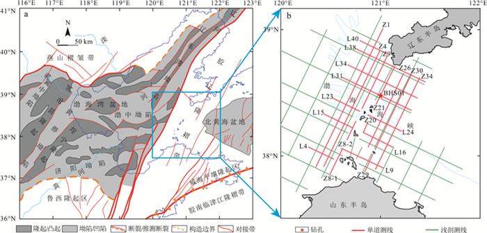
Figure 1.
Tectonic map of the Bohai Strait(a)and its adjacent area and the seismic survey line distribution(b)
-
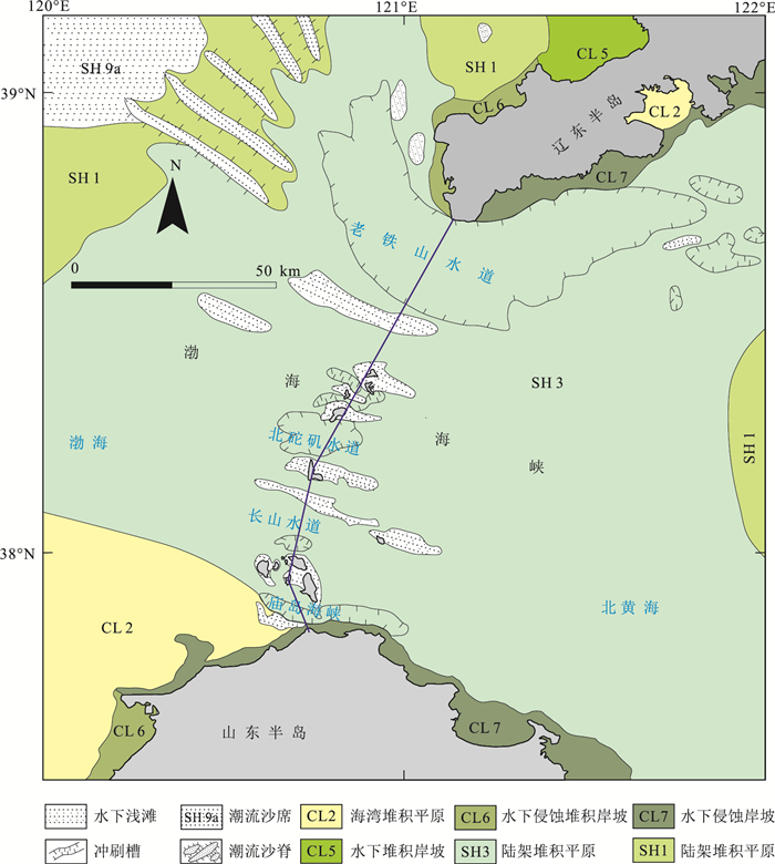
Figure 2.
Submarine geomorphic map of the Bohai Strait
-
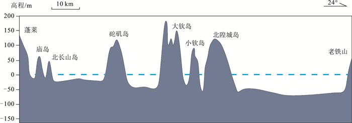
Figure 3.
Water depth profile in the Bohai Strait
-
Figure 4.
Distribution of average grain size of surface sediments in the Bohai Strait
-
Figure 5.
Lithology and magneto-stratigraphy of borehole BHS01
-
Figure 6.
The stratigraphic structure of the shallow seismic profile passing through the middle of the Laotieshan Channel
-
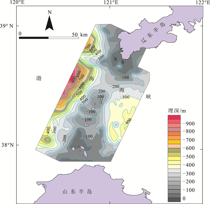
Figure 7.
Burial depth of bedrock top interface in the Bohai Strait
-
Figure 8.
Seismic profile interpretation and active faults in the Bohai strait
-
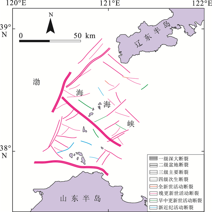
Figure 9.
Distribution of active faults in the Bohai Strait
-
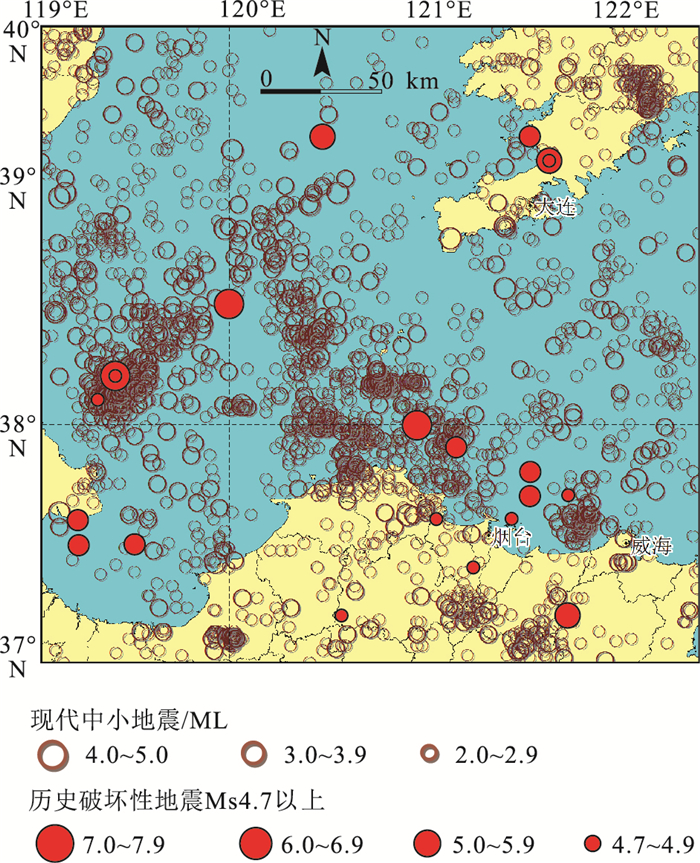
Figure 10.
Distribution of earthquake epicenters in the study area and its adjacent regions
-
Figure 11.
Distribution of geological disasters in the Bohai Strait
-
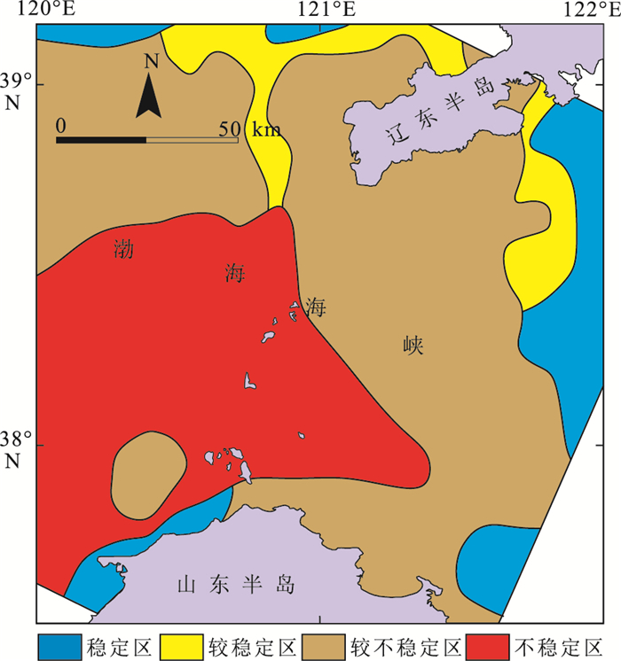
Figure 12.
Zonation map of seismic stability in the Bohai Strait and its adjacent areas