
| Citation: |
CHENG Sanyou, CHEN Jing, LIN Haixing, GU Pingyang, ZHUANG Yujun. Application of geometric precision correction based on high-resolution Remote Sensing Image in 1:50000 geological mapping[J]. Geological Bulletin of China, 2021, 40(4): 520-526.

|
Application of geometric precision correction based on high-resolution Remote Sensing Image in 1:50000 geological mapping
-
Abstract
The high resolution remote sensing images can play an important role in the 1:50000 geological mapping in the alpine-gorge area with high altitude, deep cutting and poor crossing conditions.However, the remote sensing image products provided by the current market cannot match the working base maps such as field position information and topographic maps, and their geometric accuracy seriously restricts the field investigation of geological mapping.In order to solve this practical problem, a set of geometric precision correction techniques for high resolution remote sensing images is proposed by using high resolution remote sensing image SPOT7 and exemplifying Saishiteng Mountain in the northern margin of Qaidam Basin in Qinghai-Tibet Plateau as an example.Based on the fusion registration of high-resolution remote sensing images, this method innovates the semi-automatic man-machine interactive ground control point selection method, as well as the techniques of mass selection and spatial uniform distribution of typical feature control points.Through repeatedly checking and improving the geometric accuracy of corrected remote sensing images, the geometric precision correction of high-resolution remote sensing images is realized.The corrected remote sensing images give full play to the leading role of remote sensing technology, greatly improve the efficiency of field geological mapping, and can provide technical reference for geometric precision correction of high resolution remote sensing images in complex terrain areas.
-

-
References
[1] 张进, 曲军峰, 张庆龙, 等. 基岩区构造地质填图方法思考、实践、探索[J]. 地质通报, 2018, 37(2/3): 192-221. [2] 黄理善, 李学彪, 荆林海, 等. 基于遥感技术的高寒山区矿产资源远景区快速圈定与综合评价技术集成[J]. 中国地质, 2020-02-10, 网络首发论文. https:kns.cnki.net/kcms/detail/11.1167.P.20200210.1631.002.html. [3] 李娜, 董新丰, 甘甫平, 等. 高光谱遥感技术在基岩区区域地质调查填图中的应用[J]. 地质通报, 2021, 40(1): 13-21. [4] 李永胜, 张生辉, 张彤, 等. 1: 50000矿产地质图编制与数据库建设要求[J]. 中国地质, 2020, 47(S2): 1-15. doi: 10.12029/gc2020Z201 [5] 陈圆圆, 候德华, 潘志龙, 等. 典型地区基础地质图智能编图实践——以北山地区1: 25万甜水井幅为例[J]. 地质通报, 2021-01-21, 网络首发论文. https://kns.cnki.net/kcms/detail/11.4648.P.20210121.1054.004.html. [6] 黄辉, 路彥明, 李仰春, 等. 基于多元知识和编图模型的智能地质编图技术及其应用[J]. 地质通报, 2021-01-20, 网络首发论文. https://kns.cnki.net/kcms/detail/11.4648.P.20210120.1056.004.html. [7] 辜平阳, 陈瑞明, 查显峰, 等. 高山峡谷区1: 50000地质填图技术方法探索与实践——以新疆乌什北山为例[J]. 地质力学学报, 2016, 22(4): 837-855. doi: 10.3969/j.issn.1006-6616.2016.04.004 [8] 张婷, 刘军, 骆慧琴. 1: 1万DEM的生成及SPOT-5卫星数据正射校正[J]. 遥感技术与应用, 2004, 19(5): 420-423. doi: 10.3969/j.issn.1004-0323.2004.05.025 [9] 陈静, 袁超, 陈雪洋, 等. DEM对山区高分辨率影像正射校正精度的影响[J]. 地理空间信息, 2014, 12(1): 128-131. doi: 10.11709/j.issn.1672-4623.2014.01.044 [10] 屈为刚. ENVI软件制作SPOT5遥感正射影像图方法初探[J]. 山西建筑, 2014, 40(21): 223-225. [11] 蓝晓丹, 李春干, 杜海波. 不同地面控制点采集方法对SPOT5图像几何精校正精度的影响[J]. 中南林业调查规划, 2009, 28(3): 31-35. [12] 高万里, 王宗秀, 李磊磊, 等. 柴达木盆地北缘小赛什腾山二叠纪花岗岩的发现及其构造意义[J]. 地质力学学报, 2019, 93(4): 816-829. [13] 和政军, 许志琴, 杨经绥, 等. 柴达木盆地北缘小赛什腾山晚古生代放射虫的发现及其意义[J]. 地质通报, 2002, 21(3): 156-157. [14] 杨亚莉, 赵宁, 成晓倩. 基于FLAASH模型的SPOT6卫星影像大气校正及评价[J]. 现代测绘, 2015, 38(2): 3-9. [15] 田淑芳, 詹骞. 遥感地质学[M]. 北京: 地质出版社, 2013. [16] 高晖. 不同精度控制点对遥感图像几何校正的影响[D]. 中国地质大学硕士学位论文, 2008. [17] 钟婷, 杨敏华. 高山区遥感影象与地形数据几何配准试验研究[J]. 内蒙古林学院学报(自然科学版), 1999, 21(1): 76-81. [18] 杨国东, 赵强, 张旭晴, 等. 基于SPOT6卫星遥感数据无控制点正射校正[J]. 测绘与空间地理信息, 2018, 41(7): 1-3. -
Access History
Figures(7)
Tables(1)

Export File
Citation
CHENG Sanyou, CHEN Jing, LIN Haixing, GU Pingyang, ZHUANG Yujun. Application of geometric precision correction based on high-resolution Remote Sensing Image in 1:50000 geological mapping[J]. Geological Bulletin of China, 2021, 40(4): 520-526.
Format
Content
 DownLoad:
-
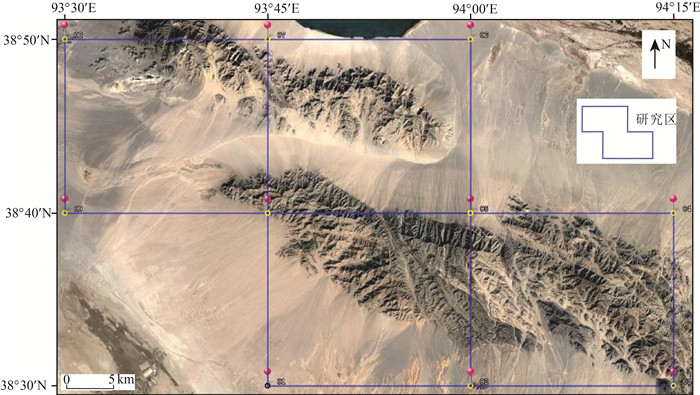
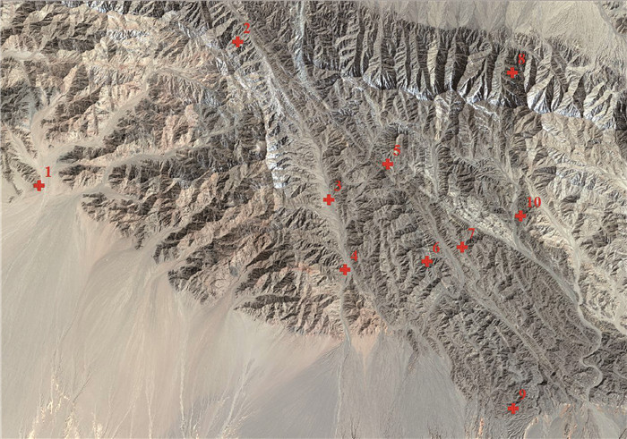
Figure 1.
Google earth satellite remote sensing map in the study area
-
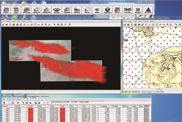
Figure 2.
Remote sensing map precisely corrected based on topographic map(1:50000)
-
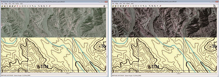
Figure 3.
SPOT7 images before correction(a) and after correction(b)
-
Figure 4.
Corrected SPOT7 remote sensing image of typical outcrops in the field of the study area
-
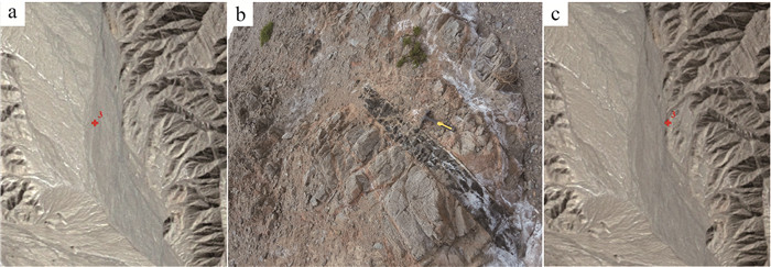
Figure 5.
SPOT7 image before correction(a), photo of outcrop SH03(b)and after correction(c) at outcrop SH03
-
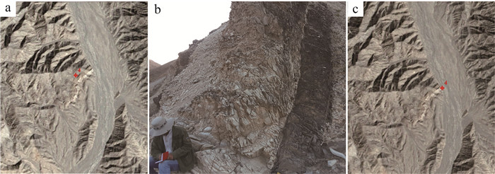
Figure 6.
SPOT7 image before correction(a), photo of outcrop SH04(b)and after correction(c) at outcrop SH04
-
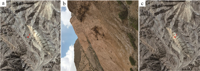
Figure 7.
SPOT7 image before correction(a), photo of outcrop SH05(b)and after correction(c) at outcrop SH05