
| Citation: |
YANG Jia-jia, BAI Lei, WU Song. STUDY ON THE EROSION IN TYPICAL BLACK SOIL AREAS OF HEILONGJIANG PROVINCE BY REMOTE SENSING MONITORING TECHNOLOGY[J]. Geology and Resources, 2019, 28(2): 193-199,183.

|
STUDY ON THE EROSION IN TYPICAL BLACK SOIL AREAS OF HEILONGJIANG PROVINCE BY REMOTE SENSING MONITORING TECHNOLOGY
-
Abstract
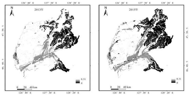
Supported by remote sensing and GIS technology, the revised universal soil loss equation(RUSLE) is used as the evaluation model to calculate the soil erosion volume in 2003 and 2015 in Suihua City of Heilongjiang Province. The distribution map of water-soil loss intensity is generated in combination with the grading standard. On this basis, the paper analyzes the current situation, spatial distribution and changes with reasons of water-soil loss during 2003-2015. The results show that with the increase of soil-water conservation measures, the soil erosion condition tends to be relieved. According to the statistical results, the proportions of strong and extremely strong erosion areas decrease, while those of the slight and light erosions increase. In 2015, the strong erosion-graded water-soil loss area reduced by 522.75 km2 compared with that in 2003, and light erosion-graded ones increased by nearly 1000 km2.
-
Keywords:
- black soil /
- soil erosion /
- remote sensing /
- RUSLE /
- Suihua City /
- Heilongjiang Province
-

-
References
[1] 孙莉英, 郑明国, 方海燕, 等.漫川漫岗黑土区水土流失综合治理范式[J].中国水土保持科学, 2012, 10(3):43-49. doi: 10.3969/j.issn.1672-3007.2012.03.007 [2] 阎百兴, 杨育红, 刘兴土, 等.东北黑土区土壤侵蚀现状与演变趋势[J].中国水土保持科学, 2008, 6(12):26-30. [3] 杨凤海, 宋佳佳, 赵烨荣, 等.东北黑土水土流失区生态环境遥感动态监测[J].东北农业大学资源与环境学院, 2018, 31(1):35-38. [4] 程晋南, 赵庚星, 李红, 等.基于RS和GIS的土地生态环境状况评价及其动态变化[J].农业工程学报, 2008, 24(11):83-88. doi: 10.3321/j.issn:1002-6819.2008.11.015 [5] 周文英, 何彬彬.四川省若尔盖县生态环境质量评价[J].地球信息科学学报, 2014, 16(2):314-319. [6] 张彬, 杨联安, 向莹, 等.基于RS和GIS的生态环境质量综合评价与时空变化分析——以湖北省秭归县为例[J].山东农业大学学报:自然科学版, 2016, 47(1):64-71. [7] 孟岩, 赵庚星.基于卫星遥感数据的河口区生态环境状况评价:以黄河三角洲垦利县为例[J].中国环境科学, 2009, 29(2):163-167. doi: 10.3321/j.issn:1000-6923.2009.02.010 [8] 屈创, 张春亮, 王丽云, 等.高分遥感在黄河流域水土流失动态监测中的应用[J].水土保持通报, 2018, 38(1):116-121. [9] 王文娟, 张树文, 李颖, 等.高分辨率遥感影像在水土流失定量评价中的应用探讨——以Quickbird影像为例[J].农业系统科学与综合研究, 2008, 24(4):441-446. doi: 10.3969/j.issn.1001-0068.2008.04.013 [10] 张登荣, 朱建丽, 徐鹏炜.基于卫星遥感和GIS技术的水土流失动态监测体系研究[J].浙江大学学报:理学版, 2001, 28(5):577-582. [11] Wishmeier W H, Smith D D. Predicting rainfall erosion losses:A guide to conservation planning[M]. Washington D C:USDA Agriculture Handbook, 1978:500-537. [12] Renard K G. Revised universal soil loss equation[J]. Journal of Soil and Water Conservation, 1991(1/2):30-33. [13] 陈燕红, 潘文斌, 蔡芫镔.基于RS/GIS和RUSLE的流域土壤侵蚀定量研究——以福建省古溪流域为例[J].地质灾害与环境保护, 2007, 18(3):5-10. doi: 10.3969/j.issn.1006-4362.2007.03.002 [14] 李晓松, 姬翠翠, 曾源, 等.基于遥感和GIS的水土流失动态监测——以河北省赤城县为例[J].生态学杂志, 2009, 28(9):1723-1729. [15] 卜兆宏, 孙金庄, 周伏建.水土流失的定量遥感及其应用研究进展[J].农村生态环境, 1995, 11(4):35-39. [16] 刘耀林, 罗志军.基于GIS的小流域水土流失遥感定量检测研究[J].武汉大学学报:信息科学版, 2006, 31(1):35-38. doi: 10.3321/j.issn:1671-8860.2006.01.010 -
Access History
Figures(9)
Tables(3)

Export File
Citation
YANG Jia-jia, BAI Lei, WU Song. STUDY ON THE EROSION IN TYPICAL BLACK SOIL AREAS OF HEILONGJIANG PROVINCE BY REMOTE SENSING MONITORING TECHNOLOGY[J]. Geology and Resources, 2019, 28(2): 193-199,183.
Format
Content
 DownLoad:
-
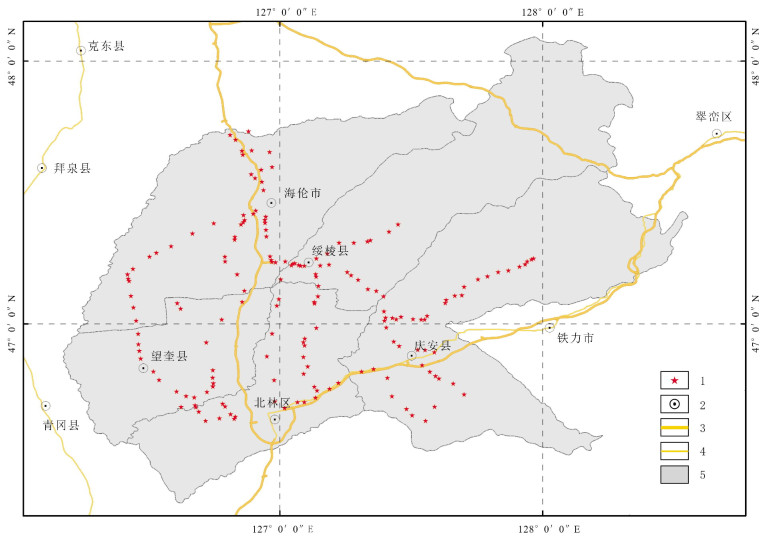
Figure 1.
The study area and ground survey spots
-
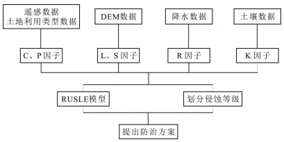
Figure 2.
Technique flowchart of RUSLE model
-
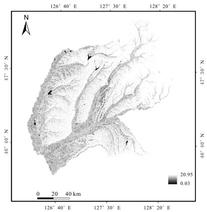
Figure 3.
Thematic map of L factor
-
Figure 4.
Thematic map of S factor
-
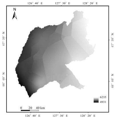
Figure 5.
Thematic map of R factor
-
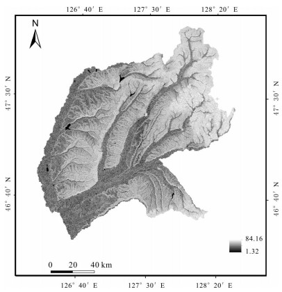
Figure 6.
Thematic map of K factor
-
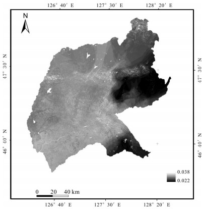
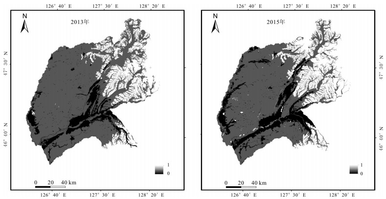
Figure 7.
Thematic map of C factor
-
Figure 8.
Thematic map of P factor
-
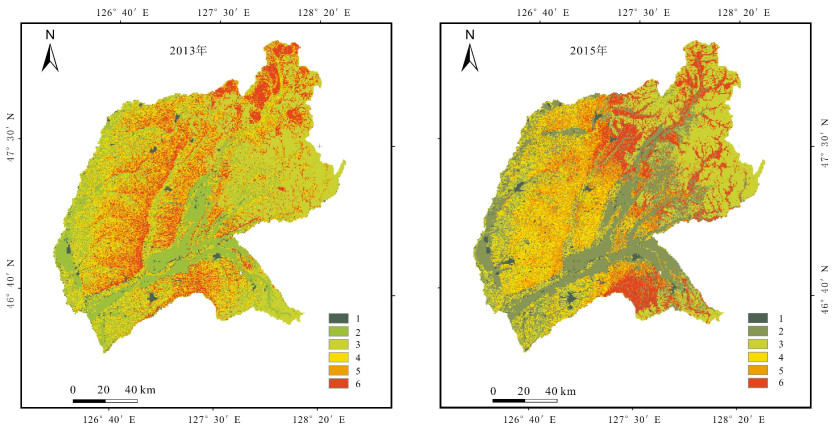
Figure 9.
Grading map of soil erosion intensity