
| Institute of Geomechanics, Chinese Academy of Geological Sciences | Host |
| Citation: |
YANG Xing-chen, YE Pei-sheng, CAI Mao-tang, ZHOU Wei. METHODS FOR THE PRODUCTION OF FIELD FREE-HAND MAPS AND GEOGRAPHIC BASEMAPS IN DIGITAL GEOLOGICAL MAPPING[J]. Journal of Geomechanics, 2017, 23(3): 333-338.

|
METHODS FOR THE PRODUCTION OF FIELD FREE-HAND MAPS AND GEOGRAPHIC BASEMAPS IN DIGITAL GEOLOGICAL MAPPING
-
Abstract
Digital mapping system realizes the informatization in the whole process of regional geological survey from field data acquisition, data processing to result output and so on. Accurate and rapid production of field free-hand maps and basemaps is the foundation of field investigation work. According to the 1:50000 scale regional geological survey, the transformation process of terrain data coordinate system is presented and a set of methods for the rapid production of field free-hand maps and basemaps that meet the relevant accuracy requirements are summarized.The first step is using the "workspace direct projection transformation" function in the projection transformation module of Mapgis 67 to enlarge the 1:50000 scale data. The second step is cutting out the enlarged 1:25000 scale terrain vector data with the Section widget.The third step is adding the latest terrain and surface features according to the remote-sensing image data to achieve the final drawing of geographic basemaps.
-

-
References
[1] 李超岭, 张克信, 墙芳躅, 等.数字区域地质调查系统技术研究[J].地球科学进展, 2002, 17(5):763~768. LI Chao-ling, ZHANG Ke-xin, QIANG Fang-zhu, et al. Research on digital regional geologic survey system techniques[J]. Advance in Earth Sciences, 2002, 17(5):763~768. [2] 谢良珍.地学专题图地理底图的编绘[J].第四纪研究, 1999, 19(3):260~267. XIE Liang-zhen.Compiling the basic map of geography for the geoscience maps[J]. Quaternary Sciences, 1999, 19(3):260~267. [3] 1: 50000区域地质调查工作指南[R]. 北京: 中国地质调查局, 2016. http://www.wenkuxiazai.com/doc/38d57d6da45177232e60a207-3.html 1: 50000 regional geological survey work instructions[R]. Beijing: China Geological Survey, 2016.[4] 李磊, 郑锦娜, 王心华.数字填图地理底图转换与制作方法研究[J].地质调查与研究, 2013, 36(4):318~320. LI Lei, ZHENG Jin-na, WANG Xin-hua.Conversion and making method for digital mapping geographic basemap[J]. Geological Survey and Research, 2013, 36(4):318~320. [5] 徐磊, 孙羽, 李永军, 等.浅谈数字填图系统背景图层的参数调整技巧与方法[J].甘肃地质, 2013, 22(1):81~85. XU Lei, SUN Yu, LI Yong-jun, et al. Methods and skills of adjusting the parameters of background layer for digital mapping[J]. Gansu Geology, 2013, 22(1):81~85. [6] Golledge N.Digital field survey technology:the future of BGS mapping?[J].Earthwise, 2004, (20):4~5. [7] 李丰丹, 李超岭, 吴亮, 等.大数据环境下数字填图数据集成服务技术[J].地质通报, 2015, 34(7):1300~1308. LI Feng-dan, LI Chao-ling, WU Liang, et al. Data integration and services of digital geological mapping based on big data[J]. Geological Bulletin of China, 2015, 34(7):1300~1308. [8] 郑雪萍.地理底图小放大编绘的几个问题[J].地矿测绘, 1999, (2):35~37. ZHENG Xue-ping.Some problems in enlargement compilation of geographic base map[J]. Surveying and Mapping of Geology and Mineral Resources, 1999, (2):35~37. [9] 陈勇, 黄建桥, 唐国强, 等.西藏地区1:5万地理底图数字化编绘质量控制[J].资源环境与工程, 2014, 28(1):74~76. CHEN Yong, HUANG Jian-qiao, TANG Guo-qiang, et al. Quality control of digital editing of 1:50000 base map in Tibet[J]. Resources Environment & Engineering, 2014, 28(1):74~76. -
Access History
Figures(5)
Tables(1)

Export File
Citation
YANG Xing-chen, YE Pei-sheng, CAI Mao-tang, ZHOU Wei. METHODS FOR THE PRODUCTION OF FIELD FREE-HAND MAPS AND GEOGRAPHIC BASEMAPS IN DIGITAL GEOLOGICAL MAPPING[J]. Journal of Geomechanics, 2017, 23(3): 333-338.
Format
Content
 DownLoad:
-
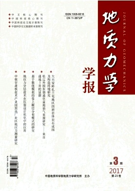
Figure 1.
Renderings of 2000 National Geodetic coordinate system setted in Mapgis 67
-
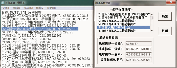
Figure 2.
Mapgis67 Projection transformation module interface
-
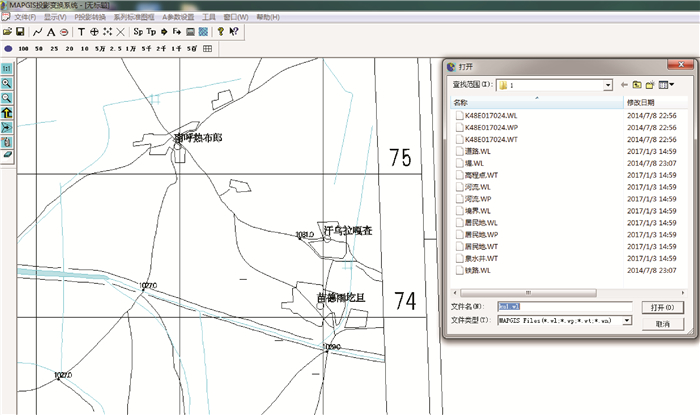
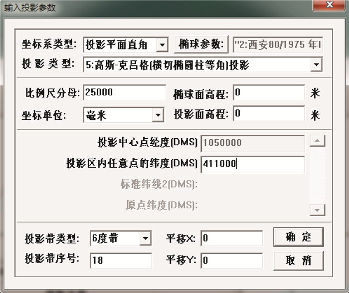
Figure 3.
Setting of the current projection parameters
-
Figure 4.
Settings of the projection results parameters
-
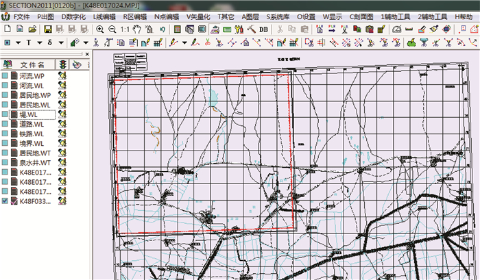
Figure 5.
Main operating interface of the Section plug-in