
| Qingdao Institute of marine geology, China Geological Survey | Host |
| Citation: |
LIU Xiqing, LIU Zhehao. The three-dimensional geomorphologic map of China Seas and adjacent regions:design and practice[J]. Marine Geology & Quaternary Geology, 2019, 39(4): 1-11. doi: 10.16562/j.cnki.0256-1492.2019052601

|
The three-dimensional geomorphologic map of China Seas and adjacent regions:design and practice
-
Abstract
The 《Geomorphologic Map of China Seas and Adjacent Regions》 is a present topographic map expressed by painting skills. It was compiled following the principle of "one map of three expression options". The shadow method is adopted for land area, and the pictographic method adopted for continental shelves, while the 3D compositional drawing method is used for the vast areas of deep sea. The original scale is 1:2 million, whereas the vertical scale is 20 times exaggerated. The map is made of in two steps: Drew pencil sketches first and then decorated with colors. All were drawn by hand. Shown on the map are the geomorphologic features of the southeastern Eurasian plate, the continental plate edge, and the Philippine Sea plate. The formation of the landscape of the area is driven by two plate boundaries, i.e. the Himalayan collision zone and West Pacific Subduction Zone. In the eastern part of China, it was dominated by the old E-W structure, superimposed by Cenozoic structures in NNE direction, and thus formed a grid-like tectonic landforms. Owing to the subduction of the Pacific Plate under the Eurasia, the Japanese basins and the Okinawa Trough were pulled apart and formed the 2 sets of trench-arc-basin systems. The South China Sea Basin was formed by the opening of the continent margin, when the Philippine arc moved north under rotation to make the South China Sea a marginal sea. The northern part of the Philippines arc collided with the island of Taiwan and resulted in the rise of the Central Mountain Range, The ocean crust thrusted onto the land and formed the Coastal Mountains. The Longitudinal Valley of Taiwan is in fact a plate suture, and the Philippine Sea plate a part of the Pacific plate. Driven by repeated subduction of oceanic crusts following fractures, formed trench-arc-basin topography along the oceanic margin.
-

-
References
[1] 刘锡清.中国海区及邻域地貌图(1: 500万)[C]//刘光鼎.中国海区及邻域地质地球物理系列图.北京: 地质出版社, 1992. LIU Xiqing. Geomorphologic map of China Sea and adjacent regions(1: 5 million)[C]//LIU Guangding.Geological and Geophysics Series Map of China Sea and Adjacent Regions.Geological Press, Beijing, 1992. [2] 刘锡清.地势图(1: 850万)[C]//刘光鼎.中国海区及邻域地质地球物理图集.北京: 科学出版社, 1993. LIU Xiqing. Earth map of China Sea and adjacent regions(1: 85 00000) [C]//LIU Guangding.Geological and Geophysical Atlas of China Sea and Adjacent Regions.Science Press, Beijing, 1993. [3] 薛万俊.南海地貌图及说明书[C]//何廉生、陈邦彦.南海地质地球物理图集.广州: 广东省地图出版社, 1987. XUE Wanjun. South China Sea landscape map and instruction[C]//Chief Editor HE Liansheng, CHEN Bangyan.Geoscience and Geophysical Atlas of South China Sea.Guangdong Map Publishing House, Guangzhou, 1987. [4] 李吉君.中国海底地势图[C]//中华人民共和国地貌图集.北京: 科学出版社, 2009. LI Jijun.Chinese submarine terrain map[C]// Landscape Atlas of People's Republic of China.Science Press, Beijing, 2009. [5] 朱本铎, 关永贤, 等.南海三维地形图(1: 200万)[C]//广州海洋地质调查局.南海地质地球物理图系.天津: 中国航海图书出版社, 2015. ZHU Benduo, GUAN Yongxian, et al.South China Sea Geological and Geophysical Atlas(1: 2000000).China Maritime Book Publishing House, Tianjin, 2015. [6] 茂木昭夫.日本近海海底地形誌—海底俯瞰図集[C].东京大学出版会, 1977. Mogi Akio.Japan Offshore Submarine Terrain Journal—submarine Overlooking the Set[C].University of Tokyo Publishing House, 1977. [7] 丛鸿文, 孙家淞, 鲍才旺.中国海区及邻域地形图(1: 500万)[C]//刘光鼎.中国海区及邻域地质地球物理系列图.北京: 地质出版社, 1992. CONG Hongwen, SUNJiasong, BAO Caiwang.Topographic maps(1: 5000000)[C]//LIU Guangding.Geological and Geophysical Series Map of China Sea and Adjacent Regions.Geological Press, Beijing, 1992. [8] 刘锡清, 孙家淞, 鲍才旺, 等.1: 850万中国海区及邻域地貌类型图[C]//刘光鼎.中国海区及邻域地质地球物理图集.北京: 科学出版社, 1993. LIU Xiqing, SUN Jiasong, BAO Caiwang, et al. Geomorphologic type map of China Sea and adjacent regions(1: 8500000) [C]// LIU Guangding.Geological and Geophysical Atlas of China Sea and Adjacent Regions.Science Press, Beijing, 1993. [9] 刘锡清, 板块构造地貌分类尝试——以中国海区及邻域为例[J].海洋地质动态, 1989(7):4-6. LIU Xiqing. An attempt to plate tectonic geomorphology classification, Take China Sea area and adjacent regions as an example[J].Marine Geological Newsletter, 1989(7):4-6. [10] 刘锡清.中国海区及邻域地貌图概述[J].海洋地质动态, 1990(3):4-6. LIU Xiqing. Summary of geomorphologic type map of China sea and adjacent regions [J].Marine Geological Newsletter, 1990(3):4-6. [11] 刘锡清, 孙家淞.板块构造地貌分类[C]//刘光鼎.中国海区及邻域地质地球物理特征.北京: 科学出版社, 1992: 12-16. LIU Xiqing, SUN Jiasong. Plate tectonic geomorphology classification[C]// LIU Guangding. Geological and Geophysical Characteristics of China's Sea Area and Adjacent Regions.Science Press, Beijing, 1992: 12-16. [12] 刘锡清, 马道修. 1:860万中国海区及邻域地貌图:板块构造地貌分类例析[J].地理学报, 1996, 51(3):240-250. doi: 10.3321/j.issn:0375-5444.1996.03.006 LIU Xiqing, MA Daoxiu.1:8600000 Geomorphologic map of China Sea and adjiacent regions——Examples of plate tectonic geomorphology classification[J].Acta Geographica Sinica, 1996, 51(3):240-250. doi: 10.3321/j.issn:0375-5444.1996.03.006 [13] 刘锡清.海底地貌学[M]//杨子赓.海洋地质学.山东教育出版社, 2002: 65-92. LIU Xiqing. Undersea geomorphology[M]//YANG Zigeng.Marine Geology.Shandong Education Publishing House, 2002: 65-92. [14] 孙家淞, 刘锡清, 马道修, 等.地貌特征和类型[M]//刘光鼎.中国海区及邻域地质地球物理特征.北京: 科学出版社, 1992: 17-24. SUN Jiasong, LIU Xiqing, MA Daoxiu, et al.Geomorphological characteristics and types[M]//LIU Guangding. Geological and Geophysical Characteristics of China's Sea Area and Adjacent Regions. Science Press, Beijing, 1992: 17-24. [15] 马道修, 刘锡清, 陈俊仁.中国近海地貌发育及演化[M]//许东禹, 刘锡清.中国近海地质.北京: 地质出版社, 1996: 54-92. MA Daoxiu, LIU Xiqing, CHEN Junren.Chinese offshore geomorphology development and evolution[M]// XU Dongyu, LIU Xiqing. China Offshore Geology. Geological Publishing House, Beijing, 1996: 54-92. [16] 刘锡清, 丛鸿文.地形特征[M]//刘光鼎.中国海区及邻域地质地球物理特征.北京: 科学出版社, 1992: 3-11. LIU Xiqing, CHONG Hongwen.Topographic features[M]//LIU Guangding. Geological and Geophysical Characteristics of China's Sea Area and Adjacent Regions. Science Press, Beijing, 1992: 3-11. [17] 李四光.东亚构造格架[C]//第16届国际地质学会论.1933, 2: 561-574. LI Siguang.East Asian tectonic framework[C]//Excerpts from the paper of the 16th International Geological Society.1933, 2: 847-857. [18] 张伯声.镶嵌的地壳[J].地质学报, 1962, 42(3):275-288. ZHANG Bosheng.Inlaid crust[J].Geological Journal, 1962, 42(3):275-288. [19] Zhu Xia. On the evolution of continental margins of China-By way of introduction[C]// LIU Guangding. Geological and Geophysical Characteristics of China Sea and Adjacent Regions.Science Press, Beijing, 1992. [20] 朱夏.中国东部板块内部盆地形成机制的初步探讨[J].石油实验地质, 1979, 00:1-9. doi: 10.11781/sysydz197900001 ZHU Xia. A preliminary discussion on the formation mechanism of inner plate basin in Eastern China [J].Petroleum Experimental Geology, 1979, 00:1-9. doi: 10.11781/sysydz197900001 [21] 朱夏, 陈焕疆.中国大陆边缘构造和盆地演化[J].石油实验地质, 1982, 4(3): 153-160, 219. ZHU Xia. CHEN Huanjiang.Chinese mainland marginal structure and basin evolution[J].Petroleum Experimental Geology, 1982, 4(3):153-160, 219. [22] 王乃梁.中国构造地貌[M]//中国科学院中国自然地理编委会.中国自然地理(地貌).北京: 科学出版社, 1980: 11-61. WANG Nailiang.Chinese tectonic landforms[M]// Editorial Board of China Natural Geography, Chinese Academy of Sciences.China Natural Geography(landform).Science Press, Beijing, 1980: 11-61. [23] 李唐根, 丘燕, 姚永坚.大地构造特征[M]//刘光鼎.中国海区及邻域地质地球物理特征.北京: 科学出版社, 1992: 248-271. LI Tanggen, QIU Yan, YAO Yongjian. The tectonic features[M]//LIU Guangding, Geological and Geophysical Characteristics of China's Sea Area and Adjacent Regions. Science Press, Beijing, 1992: 248-271. [24] 马道修.西北太平洋大陆坡、岛坡地貌[M]//刘光鼎.中国海区及邻域地质地球物理特征.北京: 科学出版社, 1992: 25-32. MA Daoxiu.Northwest Pacific Continental Slope and Island Slope Landscape[M]//LIU Guangding. Geological and Geophysical Characteristics of China's Sea Area and adjacent regions.Science Press, Beijing, 1992: 25-32. [25] 鲍才旺, 薛万俊.南海大陆坡和中央海盆的地貌类型及特征[M]//刘光鼎.中国海区及邻域地质地球物理特征.北京: 科学出版社, 1992: 33-39. BAO Caiwang, XUE Wanjun.The geomorphological types and characteristics of continental slopes and central sea basins in the South China Sea[M]// LIU Guangding. Geological and Geophysical Characteristics of China's Sea Area and Adjacent Regions. Science Press, Beijing, 1992: 33-39. [26] 李学杰, 王哲, 姚永坚, 等.西太平洋边缘构造特征及其演化[J].中国地质, 2017, 44(6): 1102-1114. LI Xuejie, WANG Zhe, YAO Yongjian, et al. The tectonic features and evolution of the west Pacific margin[J]. Geology in China, 2007, 44(6): 1102-1114. [27] 高祥林.琉球海沟的构造和运动特征[J].地球物理学进展, 2003, 18(2):293-301. doi: 10.3969/j.issn.1004-2903.2003.02.018 GAO Xianglin. The structure and movement characteristics of the Ryukyu Trench[J].Progress in Geophysics, 2003, 18(2):293-301. doi: 10.3969/j.issn.1004-2903.2003.02.018 [28] Letouzey J. Okinawa Trough genesis: Structure and evolution of back-arc basin development in a continent[J]. Marine and Petroleum Geology, 1985, 2(2): 111-130. doi: 10.1016/0264-8172(85)90002-9 [29] Iwasaki T, Hirata N, Kanazawa T, et al. Crustal and upper mantle structure in the Ryukyu islandarc deduced from deep seismic sounding[J]. Geophysical Journal International, 1990, 102(3): 631-651. doi: 10.1111/j.1365-246X.1990.tb04587.x [30] 赵金海, 唐建, 王禹杰.冲绳海槽新生代构造演化讨论[J].海洋石油, 2003, 23(3):1-9. doi: 10.3969/j.issn.1008-2336.2003.03.001 ZHAO Jinhai, Tang jian, WANG Yujie.Discussion on Cenozoic tectonic evolution of Okinawan Trough[J].Offshore Oil, 2003, 23(3):1-9. doi: 10.3969/j.issn.1008-2336.2003.03.001 [31] 黄镇国, 张伟强, 钟新基.台湾板块构造与环境演变[M].北京:海洋出版社, 1995:19-95. HUANG Zhenguo, ZHANG Weiqiang, ZHONG XInji. Taiwan Plate Tectonics and Environmental Evolution[M]. Ocean Press, Beijing, 1995: 19-95. [32] 谢以宣.我国南海诸岛的地貌特征[J].南海海洋科学集刊, 1984(6):7-15. XIE Yixuan.The geomorphological features of the islands in the South China Sea[J]. Nanhai Studia Marina Sinica, 1984(6):7-15. [33] 黄镇国.中国热带第四纪板块构造的地貌效应[J].地理科学, 2004, 24(3):286-291. doi: 10.3969/j.issn.1000-0690.2004.03.006 HUANG Zhenguo. The geomorphological effects of Quaternary plate tectonics in tropical China[J].Scientia Geographica Sinica, 2004, 24(3):286-291. doi: 10.3969/j.issn.1000-0690.2004.03.006 [34] 尹延鸿, 温珍河, 孙桂华, 等.中国南部海区及邻域构造图编图说明书[C].北京: 海洋出版社, 2010: 21-25. YIN Yanhong, WEN Zhenhe, SUN Guihua, et al.Tnstruction of Geotectonic map of the southern China Sea area and Neighbourhood[C].Ocean Press, Beijing, 2010: 21-25. [35] 张斌, 李广雪, 黄继峰.菲律宾海构造地貌特征[J].海洋地质与第四纪地质, 2014, 34(2):79-88. ZHANG Bin, LI Guangxue, HUANG Jifeng. The tectonic geomorphology of the Pilppine Sea[J].Marine Geology & Quaternary Geology, 2014, 34(2):79-88. [36] 中国科学院地理研究所.中国1:100万地貌制图规范(征求意见稿)[M].北京:科学出版社, 1987. Institute of Geography, Chinese Academy of Sciences ed.1:1000000 Geomorphological Mapping Specification (trial) [M].Beijing: Science Press, 1987. [37] Demek J, Embleton C, et al. International geomorphological map of Europe (1: 2500 000). Cartography. Lithography and printing: Geodetiky a kartograficky Podnik Praha. S. P.1976, 1988, 1989. [38] 尹泽生.1:250万欧洲国际地貌图评价[J].地理译报, 1982(3):28-35. YIN Zesheng. 1:2500000 European International Landscape Map Evaluation[J].Geographic Translation, 1982(3): 28-35. [39] 巴舍尼纳H B.250万欧洲国际地貌图图例系统[J].地理制图研究, 1979, 1. Bashenina H B.Legend system of European International Landscape Map(1:2500000)[J].Study of Geographical Mapping, 1979, 1. [40] 刘锡清.直观海底形态(文/图)[J].国家地理杂志, 1998(7):52-53. lIU Xiqing. Intuitive seabed morphology(Text / Chart)[J].CNG, 1998(7):52-53. [41] 刘锡清.渤海、黄海、东海地势图, 南海地势图[C]//国家海洋局.中国海洋政策图集.中国人民解放军海军出版社, 2006. LIU Xiqing. Earth map of the Bohai Sea, Yellow Sea and East China Sea, Earth map of South China Sea Map[C]//State Oceanic Administration ed.Atlas of China's Maritime Policy.People's Liberation Army Navy Press, 2006. [42] 中国地理学会, 中国国家地理杂志社.中国地理百年大发现入围名单[J].中国国家地理, 2009(10):175, 388. China Geographical Society, China National Geographic Magazine.The Centenary Discovery of Chinese Geography Finalists[J].China National Geographic, 2009(10): 175, 388. [43] 戴勤奋.从《中国海区及邻域立体地貌图》说起[R].WWW.docin.com.2017-2-27.Daiqinfen. DAI Qinfen.Starting with 《The three-dimensional landscape map of China′s Sea areas and neighboring regions》 [R]. WWW.docin.com. Daiqinfen, 2017-2-27. -
Access History
Figures(5)

Export File
Citation
LIU Xiqing, LIU Zhehao. The three-dimensional geomorphologic map of China Seas and adjacent regions:design and practice[J]. Marine Geology & Quaternary Geology, 2019, 39(4): 1-11. doi: 10.16562/j.cnki.0256-1492.2019052601
Format
Content
 DownLoad:

-
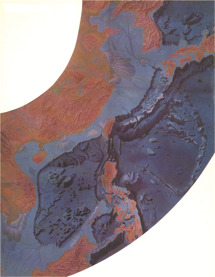
Figure 1.
Geomorphologic map of China Seas and adjacent regions (LIU Xiqing, 1992)
-
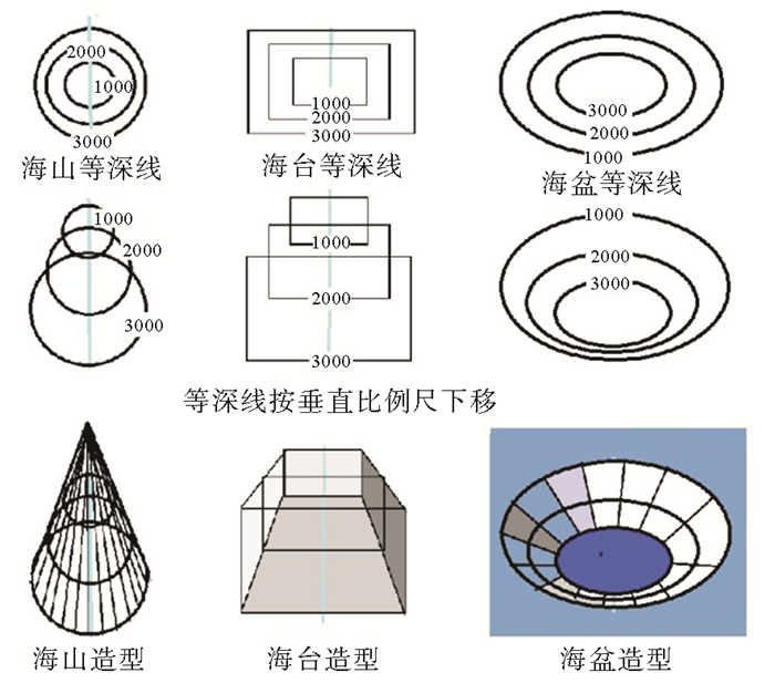
Figure 2.
Examples of stereoscopic landscape maps
-
Figure 3.
Three-dimensional modeling diagram
-
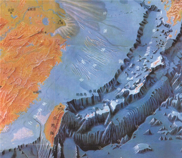
Figure 4.
East China Sea——part of the Geomorphologic Map of China Seas and Adjacent Regions
-
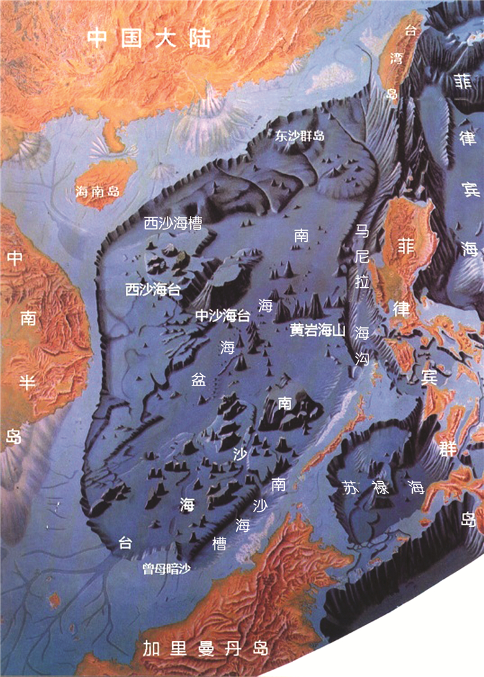
Figure 5.
South China Sea——part of the Geomorphologic Map of China Seas and Adjacent Regions