
| Citation: |
HONG Tao, ZHU Yueqin, GUO Yanjun, JIAO Shoutao, QIANG Weifan, GAO Zhenji. 2023. The construction method of interactive geological scene model based on XR technology. Geological Bulletin of China, 42(2-3): 469-478. doi: 10.12097/j.issn.1671-2552.2023.2-3.024

|
The construction method of interactive geological scene model based on XR technology
-
Abstract
The Extended Reality Technology (XR) includes Virtual Reality (VR), Augmented Reality (AR), and Mixed Reality (MR).With the development of computer hardware and software, these technologies have gradually entered the public view and have been applied to various fields.XR technology can make abstract concepts more intuitively and dynamically in geoscience, which can promote geological data visualization, geographic information interaction and geoscience education.This paper introduces the basic concepts and technical means of these technologies, as well as the current situation of the development of Extended Reality Technology in the geoscience, and advanced several interaction patterns in extended reality technology.Besides, in this paper we choose Danyang Quaternary System model to build three demos in each VR, AR and MR devices with each 3 3D-Engines: IdeaVR, Unity 3D and UnrealEngine, explore the characteristics, advantages and disadvantages of the three technology platforms, and summarize the practical methods suitable for geoscience display.This paper also proposes solutions to the problems that may occur when geological data are imported into a 3D engine.
-
Keywords:
- Extended Reality /
- Virtual Reality /
- Augmented Reality /
- Mixed Reality /
- geoscience
-

-
References
[1] Goldman Sachs INC. Virtual & Augmented Reality: Understanding the race for the next computing platform[R/OL]. (2021-12-10) Americas: Technology, 2016. [2] Steinberger J, Qureshi S. The Role of Augmented Reality and Virtual Reality in Contemporary Spine Surgery[J]. Contemporary Spine Surgery, 2020, 21(8) : 1-5. doi: 10.1097/01.CSS.0000689552.57650.21 [3] Myrden A, Chau T. Effects of user mental state on EEG-BCI performance[J]. Front. Hum. Neurosci., 2015, 9: 308. [4] Rashkov G, Bobe A, Fastovets D, et al. Natural image reconstruction from brain waves: a novel visual BCI system with native feedback[J/OL]. bioRxiv, 2019. https://www.biorxiv.org/content/biorxiv/earty/2019/10/25/787101.full.pdf [5] Samsung. The Next Hyper-Connected Experience for All[R/OL]. [2021-12-10]. https://chinaflashmarket.com/Uploads/Report/20200714145321809946.pdf . 2020.[6] 段建刚. 基于ArcEngine开发插件式GIS应用程序[J]. 测绘与空间地理信息, 2015, 38(5) : 137-138, 141. [7] 郭艳军, 张进江, 陈斌, 等. 基于VR技术的多尺度地质数据3D沉浸式可视化与交互方法[J]. 地学前缘, 2019, 26(4) : 146-158. [8] 郭艳军, 周哲, 林贺洵, 等. 基于深度学习的智能矿物识别方法研究[J]. 地学前缘, 2020, 27(5) : 39-47. [9] 黄龙, 徐富明, 胡笑羽. 眼动轨迹匹配法: 一种研究决策过程的新方法[J]. 心理科学进展, 2020, 28(9) : 1454-1461. [10] 焦汉科, 黄悦. 基于ArcEngine的插件式GIS开发框架设计与应用研究[J]. 测绘与空间地理信息, 2017, 40(1) : 128-131. doi: 10.3969/j.issn.1672-5867.2017.01.037 [11] 刘颜东. 虚拟现实技术的现状与发展[J]. 中国设备工程, 2020, (14) : 162-164. doi: 10.3969/j.issn.1671-0711.2020.14.084 [12] 强伟帆, 郭艳军, 周哲, 等. 虚拟仿真技术在地质学中的应用[J]. 高校地质学报, 2020, 26(4) : 464-471. [13] 任伟. 虚拟现实技术在地质科普中的应用[J]. 地质论评, 2017, 63(S1) : 378-379. [14] 田君良, 谢云开, 唐小贝, 等. 基于Terra Vista的真实大地景模拟仿真[J]. 指挥控制与仿真, 2013, 35(1) : 83-86. [15] 田宜平, 吴冲龙, 翁正平, 等. 地质大数据可视化关键技术探讨[J]. 地质科技通报, 2020, 39(4) : 29-36. [16] 王宏琳. 通向智能勘探与生产之路[J]. 石油工业计算机应用, 2016, 24(4) : 7-20. [17] 王连勇, 孙建刚, 彭永鹏, 等. 基于AR技术的地质公园文化旅游系统的设计与开发[J]. 大连民族大学学报, 2019, 21(5) : 435-440. [18] 王寅. 增强现实与虚拟现实技术在地质工作中的应用探讨[J]. 科学技术创新, 2018, (25) : 65-66. [19] 王珏璠, 王海鹰, 焦学军. 基于Unity 3D的三维虚拟地理教学系统初探[J]. 测绘与空间地理信息, 2020, 43(3) : 26-30, 33. [20] 于向前, 郭艳军, 张媛. 虚拟仿真技术在空间科学实验教学中的应用[J]. 实验室研究与探索, 2020, 39(2) : 131-135. [21] 赵沁平, 周彬, 李甲, 等. 虚拟现实技术研究进展[J]. 科技导报, 2016, 34(14) : 71-75. ① 发展规划局. 创新2050: 科学技术与中国的未来[R]. 北京: 中国科学院科技战略咨询研究院, 2014. -
Access History
Figures(7)
Tables(1)

Export File
Citation
HONG Tao, ZHU Yueqin, GUO Yanjun, JIAO Shoutao, QIANG Weifan, GAO Zhenji. 2023. The construction method of interactive geological scene model based on XR technology. Geological Bulletin of China, 42(2-3): 469-478. doi: 10.12097/j.issn.1671-2552.2023.2-3.024
Format
Content
 DownLoad:


-
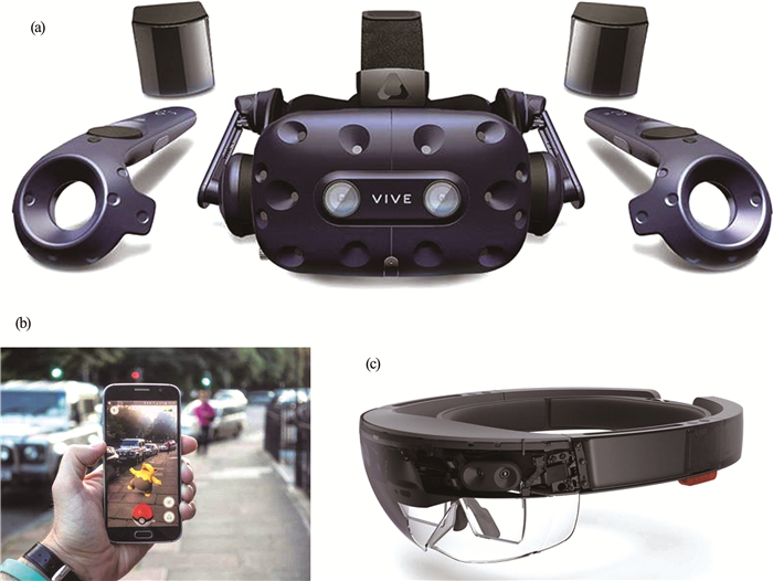
Figure 1.
Common VR (a, HTC VIVE Pro), AR (b, Smart Phone), MR (c, Microsoft HoloLens) devices
-
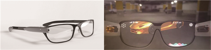
Figure 2.
Conceptual product of AR(MR) glasses, Apple Inc, 2020
-
Figure 3.
Interaction between the users and virtual environment
-
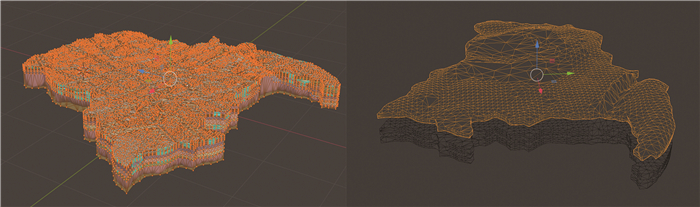
Figure 4.
Decimation of 3D models
-
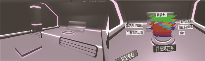
Figure 5.
VR environment (left) & VR screen (right)
-
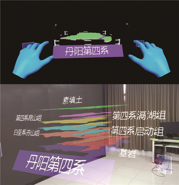
Figure 6.
Image feature tags & AR effects
-
Figure 7.
HoloLens production process and final effects