

| Citation: |
YAO Xiaofeng, YANG Jianfeng, ZUO Liyan, ZHANG Tingting, CHEN Ji, ZHANG Cuiguang. Discussion on connotation and survey strategy of the ground substrate[J]. Geological Bulletin of China, 2022, 41(12): 2097-2105. doi: 10.12097/j.issn.1671-2552.2022.12.002

|
Discussion on connotation and survey strategy of the ground substrate
-
Abstract
The ground substrate is a new concept in the natural resource management area, and there are also controversies on that's connotation and how to plan the national survey.We defined it as the sub-ground material and function carrier of the Earth's Critical Zone, and believed it's lower boundary as the bottom of the phreatic layer.The rock, Quaternary sediments in geological fields and rock-, gravel-, soil-, mud-ground substrates can be composed by the same materials with different name.The investigated results of rock and Quaternary sediments can be transferred into different kinds of ground substrate.The ground substrate survey should be conducted on the basis of regional geological survey, hydrogeology survey, geochemical survey of land quality, soil general survey of soil to achieve the data of compositions, spatial distribution, physical and chemical characteristics of ground substrate.Moreover, the datas of ground substrate between the surveyed zone and the lower boundary of the phreatic layer, and some other unanalyzed data should be added.Furthermore, the research related to the function how the ground substrate affects the upper forest, grass and wetland needs to be strengthened.We supposed that the ground substrate survey should be deployed according to the comprehensive natural resource factors regionalization system in three steps.The first batch should focus on the areas with ecological problems such as grassland degradation, forest attenuation, soil erosion, to locate the problems and provide suggestions for ecological protection and restoration.The second batch should concentrate on key classic area of each Ⅱ grade regionalization area, conduct limited and necessary ground substrate of the scale of 1:250, 000 to map the Ⅱ grade area.The third batch should conduct compiling the national and regional map after the second batch, to provide some basic data and documents for territorial spatial planning.
-
Keywords:
- ground substrate /
- Quaternary sediments /
- soil /
- survey strategy /
- geological survey engineering
-

-
References
[1] 自然资源部. 自然资源部关于印发《自然资源调查监测体系构建总体方案》的通知[EB/OL](2020-01-17)[2020-06-01]http://gi.mnr.gov.cn/202001/t20200117_2498071.html. [2] 自然资源部. 自然资源部办公厅关于印发《地表基质分类方案(试行)》的通知[EB/OL](2020-12-12)[2020-12-12]http://www.gov.cn/zhengce/zhengceku/2020-12/23/content_5572445.htm. [3] 葛良胜, 杨贵才. 自然资源调查监测工作新领域: 地表基质调查[J]. 中国国土资源经济, 2020, 33(9): 4-11. [4] 殷志强, 秦小光, 张蜀冀, 等. 地表基质分类及调查初步研究[J]. 水文地质工程地质, 2020, 47(6): 8-14. [5] 杨静慧. 植物学[M]. 北京: 中国农业大学出版社, 2014. [6] 王京彬, 卫晓锋, 张会琼, 等. 基于地质建造的生态地质调查方法——以河北省承德市国家生态文明示范区综合地质调查为例[J]. 中国地质, 2020, 47(6): 1611-1624. [7] 杨建锋, 张翠光. 地球关键带: 地质环境研究的新框架[J]. 水文地质工程地质, 2014, 41(3): 98-104. [8] Lin H. Earth's Critical Zone and hydropedology: concepts, characteristics, and advances[J]. Hydrology Earth System Sciences, 2010, 14 (1): 25-45. doi: 10.5194/hess-14-25-2010 [9] National Science Foundation. NSF-supported scientists present new research results on Earth's critical zone[EB/OL](2018-12-13)[2020-06-01]https://www.innovations-report.com/earth-sciences/nsf-supported-scientists-present-new-research-results-on-earth-s-critical-zone/2018. [10] GB/T17412.1/2/3—1998. 岩石学分类和命名方案 火成岩岩石分类和命名方案[S]. 北京: 国家质量技术监督局, 1998. [11] Wentworth C K. A scale of grade and class terms for clastic sediments[J]. Journal of Geology, 1922, 30(5): 377-392. doi: 10.1086/622910 [12] 张甘霖, 王秋兵, 张凤荣, 等. 中国土壤系统分类土族和土系划分标准[J]. 土壤学报, 2013, 50(4): 826-834. [13] 张富元, 李安春, 林振宏, 等. 深海沉积物分类与命名[J]. 海洋与湖沼, 2006, (6): 517-523. [14] 田明中, 程捷. 第四纪地质学与地貌学[M]. 北京: 地质出版社, 2009. [15] 胡健民, 陈虹, 邱士东, 等. 覆盖区区域地质调查(1: 50000)思路, 原则与方法[J]. 地球科学, 2020, 45(12): 4291-4312. [16] 自然资源部. 自然资源部关于印发《第三次全国土地调查总体方案》的通知[EB/OL](2018-01-11)[2020-06-01]http://www.gov.cn/xinwen/2018-01/12/content_5255923.htm. [17] 自然资源部. 国务院第三次全国国土调查领导小组办公室关于印发《第三次全国国土调查耕地资源质量分类工作方案》的通知[EB/OL](2020-09-16)[2020-09-16]http://gi.mnr.gov.cn/202009/t20200916_2558088.html. [18] 中华人民共和国中央人民政府. 国务院关于开展第三次全国土壤普查的通知[EB/OL](2020-01-29)[2020-06-01]http://www.gov.cn/zhengce/content/2022-02/16/content_5673906.htm. [19] 农业农村部. 第三次全国土壤普查工作方案[EB/OL](2020-02-17)[2020-06-01]http://www.gov.cn/xinwen/2022-02/24/content_5675442.htm. [20] 石建省, 马荣, 马震. 区域地球多圈层交互带调查探索研究[J]. 地球学报, 2019, 40(6): 767-780. [21] 聂洪峰, 肖春蕾, 任伟祥, 等. 生态地质研究进展与展望[J]. 中国地质调查, 2021, 8(6): 1-8. [22] 郝爱兵, 殷志强, 彭令, 等. 学理与法理和管理相结合的自然资源分类刍议[J]. 水文地质工程地质, 2020, 47(6): 1-7. [23] 李响, 周效华, 相振群, 等. 地表基质调查的工作思路刍议: 以海南岛为例[J/OL]. 地质通报, https://kns.cnki.net/kcms/detail/11.4648.P.20210827.1805.002.html. 2021. [24] 陈发虎, 傅伯杰, 夏军, 等. 近70年来中国自然地理与生存环境基础研究的重要进展与展望[J]. 中国科学: 地球科学, 2019, 41(11): 1659-1696. [25] 张新时. 中国山地植被垂直带的基本生态地理类型. [M]//姜恕主编. 植被生态学研究. 北京: 科学出版社, 1994. [26] 张百平, 姚永慧. 山体效应研究[M]. 北京: 中国环境出版社, 2015. [27] Zhang B, Yao Y. Implications of mass elevation effect for the altitudinal patterns of global ecology[J]. Journal of Geographical Sciences, 2016, 26: 871-877. [28] Banwart S, Menon M, Bernasconi S M, et al. Soil processes and functions across an international network of Critical Zone Observatories: Introduction to experimental methods and initial results[J]. Comptes Rendus Geoscience, 2012, 344: 758-772. [29] 田明中, 张绪教, 曹伯勋, 等. 1: 5万区域地质调查中第四纪地质的研究内容与图件表示原则及方法[J]. 第四纪研究, 1999, (3): 217-223. [30] 闵隆瑞, 王永, 王成, 等. 一幅新的第四纪地质及地貌图的编制——以宁夏与山东为例[J]. 中国地质, 2016, 43(3): 1026-1032. [31] 蔡运龙. 当代自然地理学态势[J]. 地理研究, 2010, 29: 1-12. [32] 中华人民共和国中央人民政府. 国家发展改革委 自然资源部关于印发《全国重要生态系统保护和修复重大工程总体规划(2021-2035年)》的通知[EB/OL](2020-06-03)[2020-06-03]http://www.gov.cn/zhengce/zhengceku/2020-06/12/content_5518982.htm. [33] 王浩, 胡鹏. 水循环视角下的黄河流域生态保护关键问题[J]. 水利学报, 2020, 51(9): 1009-1014. [34] 刘江, 谢遵博, 王千慧, 等. 北方防沙带东部区生态安全格局构建及优化[J]. 生态学杂志, 2021, 40(11): 3412-3423. [35] 卢欣石, 何琪. 内蒙古草原带防沙治沙现状, 分区和对策[J]. 中国农业资源与区划, 2000, 21(4): 58-62. [36] 付景保. 黄河流域生态环境多主体协同治理研究[J]. 灌溉排水学报, 2020, 39(10): 130-137. [37] 刘宪春, 温美丽, 刘洪鹄. 东北黑土区水土流失及防治对策研究[J]. 水土保持研究, 2005, 12(2): 74-76. [38] 田清. 近60年来气候变化和人类活动对黄河、长江、珠江水沙通量影响的研究[D]. 华东师范大学博士学位论文, 2016. [39] 中国科学院东北地理与农业生态研究所. 中国综合自然区划图[M]. 北京: 科学出版社, 1989. [40] 张海燕, 樊江文, 黄麟, 等. 中国自然资源综合区划理论研究与技术方案[J]. 资源科学, 2020, 42(10): 1870-1882. ① 郝爱兵, 林良俊, 聂洪峰, 等. 生态地质调查技术要求(1: 50000)(试行). 中国地质调查局, 2019. ② 王涛, 毛晓长, 邱士东, 等. 区域地质调查技术要求(1: 50000). 中国地质调查局, 2019. ③ 于庆文. 1/25万区域地质调查技术要求. 中国地质调查局, 2002. ④ 董庆吉, 张翠光, 杨建锋, 等. 全国地质调查工作程度图集. 中国地质调查局, 2022. ⑤ 奚小环, 任天祥, 陈国光, 等. 多目标区域地球化学调查规范(1: 250000). 中国地质调查局, 2005. ⑥ 郝爱兵, 张二勇, 韩双宝, 等. 水文地质调查技术要求(1: 50000). 中国地质调查局, 2019. -
Access History
Figures(2)
Tables(2)

Export File
Citation
YAO Xiaofeng, YANG Jianfeng, ZUO Liyan, ZHANG Tingting, CHEN Ji, ZHANG Cuiguang. Discussion on connotation and survey strategy of the ground substrate[J]. Geological Bulletin of China, 2022, 41(12): 2097-2105. doi: 10.12097/j.issn.1671-2552.2022.12.002
Format
Content
 DownLoad:

-
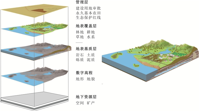
Figure 1.
The projection of ground substrate, natural resources, and some management boundary
-
Figure 2.
The spatial relationship among ground substrate and some other similar concept