| Citation: | Yong Li, Ming-zheng Wen, Heng Yu, Peng Yang, Fei-cui Wang, Fu Wang, 2024. Changes of coastline and tidal flat and its implication for ecological protection under human activities: Take China's Bohai Bay as an example, China Geology, 7, 26-35. doi: 10.31035/cg2023007 |
Changes of coastline and tidal flat and its implication for ecological protection under human activities: Take China's Bohai Bay as an example
-
Abstract
The change processes and trends of shoreline and tidal flat forced by human activities are essential issues for the sustainability of coastal area, which is also of great significance for understanding coastal ecological environment changes and even global changes. Based on field measurements, combined with Linear Regression (LR) model and Inverse Distance Weighing (IDW) method, this paper presents detailed analysis on the change history and trend of the shoreline and tidal flat in Bohai Bay. The shoreline faces a high erosion chance under the action of natural factors, while the tidal flat faces a different erosion and deposition patterns in Bohai Bay due to the impact of human activities. The implication of change rule for ecological protection and recovery is also discussed. Measures should be taken to protect the coastal ecological environment. The models used in this paper show a high correlation coefficient between observed and modeling data, which means that this method can be used to predict the changing trend of shoreline and tidal flat. The research results of present study can provide scientific supports for future coastal protection and management.
-

-
References
Abushandi E, Abualkishik A. 2020. Shoreline erosion assessment modelling for sohar region: measurements, analysis, and scenario. Scientific Reports, 10, 4048. doi: 10.1038/s41598-020-61033-y Bai YC, Shi FS, Xu HY, Huang Z. 2021. Coastline and tidal current changes responses due to large-scale reclamation in Bohai Sea. Marine Science Bulletin, 40(6), 621–635 (in Chinese with English abstract). Blum MD, Roberts HH. 2009. Drowning of the Mississippi Delta due to insufficient sediment supply and global sea-level rise. Nature Geoscience, 2(7), 488–491. doi: 10.1038/ngeo553 Ding XS, Shan XJ, Chen YL, Jin XS, Muhammed FR. 2019. Dynamics of shoreline and land reclamation from 1985 to 2015 in the Bohai Sea. Journal of Geographical Sciences, 29(12), 2031–2046. doi: 10.1007/s11442-019-1703-1 Ericson JP, Vorosmarty CJ, Dingman SL, Ward LG, Meybeck M. 2006. Effective sea-level rise and deltas: Causes of change and human dimension implications. Global and Planetary Change, 50(1–2), 63–82. doi: 10.1016/j.gloplacha.2005.07.004. Fan YS, Chen SL, Zhao B, Ji HY, Jiang C. 2018. Monitoring tidal flat dynamics affected by human activities along an eroded coast in the Yellow River Delta. Environmental Monitoring and Assessment, 190(7), 396. doi: 10.1007/s10661-018-6747-7 Günaydin K, Kabdasli S. 2003. Characteristics of coastal erosion geometry under regular and irregular waves. Ocean Engineering, 30(13), 1579–1593. doi: 10.1016/S0029-8018(03)00011-8 Hou XY, Wu T, Hou W, Chen Q, Wang YD, Yu LJ. 2016. Characteristics of coastline changes in mainland China since the early 1940s. Science China Earth Sciences, 59, 1791–1802. doi: 10.1007/s11430-016-5317-5 IPCC. 2013. Fifth Report-Climate Change, the Physical Science Basis. Web site: https://www.ipcc.ch/report/ar5/wg1/. IPCC. 2021. Sixth Report-Climate Change, the Physical Science Basis. Web site: https://www.ipcc.ch/report/ar6/wg1/. Jaffe BE, Smith RE, Foxgrover AC. 2007. Anthropogenic influence on sedimentation and intertidal mudflat change in San Pablo Bay, California: 1856–1983. Estuarine Coastal and Shelf Science, 73(1–2), 175–187. doi: 10.1016/j.ecss.2007.02.017. Jia H, Shen YM, Su MR, Yu CX. 2018. Numerical simulation of hydrodynamic and water quality effects of shoreline changes in Bohai Bay. Frontiers of Earth Science, 12(3), 625–639. doi: 10.1007/s11707-018-0688-x Jiang C, Pan S, Chen SL. 2017. Recent morphological changes of the Yellow River (Huanghe) submerged delta: causes and environmental implications. Geomorphology, 293(Part A), 93–107. doi: 10.1016/j.geomorph.2017.04.036. Lai S, Loke LHL, Hilton MJ, Bouma TJ, Todd PA. 2015. The effects of urbanization on coastal habitats and the potential for ecological engineering: A Singapore case study. Ocean and Coastal Management, 103, 78–85. doi: 10.1016/j.ocecoaman.2014.11.006 Li Y, Tian LZ, Pei YD, Wang F, Wang H. 2016. Numerical simulation of storm surge inundation in the west zone of Bohai Bay. Geological Bulletin of China, 35(10), 1638–1645 (in Chinese with English abstract). Li Y, Chen X, Tian LZ, Li JF. 2017. Numerical simulation of the storm surge in Bohai Bay based on a coupled ocean-atmosphere model. Journal of Shanghai Jiaotong University, 51(12), 1512–1519. doi: 10.16183/j.cnki.jsjtu.2017.12.015 Li Y, Chen X, Jiang XY, Li JF, Tian LZ. 2019. Numerical simulations and comparative analysis for two types of storm surges in the Bohai Sea using a coupled atmosphere-ocean model. Acta Oceanologica Sinica, 38(9), 39–51. doi: 10.1007/s13131-019-1383-9 Li Y, Wen MZ, Yang P, Tian LZ, Hu YZ, Wang H. 2021. Construction of "atmosphere-land-sea" comprehensive geological survey and observation system in Tianjin and Hebei coastal zone. North China Geology, 44(4), 40–46 (in Chinese with English abstract). Li YN, Wang Q, Guo PF, Zhang SY, Hu H. 2015. Shoreline succession during recent 20 years in the Bohai Sea and the strategies for the development and utilization. Transactions of Oceanology and Limnology, (3), 32–38 (in Chinese with English abstract). Liu H, Jezek KC. 2004. Automated extraction of coastline from satellite imagery by integrating Canny edge detection and local adaptive thresholding method. International Journal of Remote Sensing, 25(5), 937–958. doi: 10.1080/0143116031000139890 Liu YF, Ma J, Wang XX, Zhong QY, Zong JM, Wu WB, Wang Q, Zhao B. 2020. Joint effect of spartina alterniflora invasion and reclamation on the spatial and temporal dynamics of tidal flats in Yangtze River estuary. Remote Sensing, 12(11), 1725. doi: 10.3390/rs12111725 Luan HL, Ding PX, Wang ZB, Ge JZ Yang SL. 2016. Decadal morphological evolution of the Yangtze Estuary in response to river input changes and estuarine engineering projects. Geomorphology, 265(4), 12–23. doi: 10.1016/j.geomorph.2016.04.022 MLR. 2021. Sea level bulletins 2020. Ministry of land resources, People’s Republic of China. Web site: http://www.nmdis.org.cn/hygb/zghpmgb/ (in Chinese). NDRC. 2020. Master plan for major national ecosystem protection and restoration projects (2021–2035). Web site: http://www.ndrc.gov.cn/xxgk/zcfb/tz/202006/t20200611_1231112_ext.html (in Chinese). Pethick J. 2001. Coastal management and sea-level rise. Catena, 42(2–4), 307–322. doi: 0.1016/S0341-8162(00)00143-0. Qiao G, Mi H, Wang WA, Tong XH, Li ZB, Li T, Liu SJ, Hong Y. 2018. 55-year (1960–2015) spatiotemporal shoreline change analysis using historical DISP and Landsat time series data in Shanghai. International Journal of Applied Earth Observation and Geoinformation, 68, 238–251. doi: 10.1016/j.jag.2018.02.009 Sardá R, Avila C, Mora J. 2005. A methodological approach to be used in integrated coastal zone management processes: The case of the Catalan Coast (Catalonia, Spain). Estuarine, Coastal and Shelf Science, 62(3), 427–439. doi: 10.1016/j.ecss.2004.09.028. Shi PX, Wang F, Shang ZW, Kang H, Xiao GQ, Yang JL, Li JF, Jiang XY, Chen YS, Tian LZ, Li Y. 2016. The present situation and changing characteristics of the shoreline along Tianjin-Hebei coastal areas and proposal for protection. Geological Bulletin of China, 35(10), 1630–1637 (in Chinese with English abstract). Wang F, Pei YD, Li JF, Shang ZW, Fan CF, Tian LZ, Song MY, Geng Y, Wang H. 2010. Current elevation of Tianjin tidal zone and the urban safety of Binhai New Area, China. Geological Bulletin of China, 29(5), 682–687 (in Chinese with English abstract). Wang F, Shang ZW, Li JF, Jiang XY, Wen MZ, Shi PX, Tian LZ, Chen YS, Yang P, Hu YZ, Li Y, Yuan HF, Wang H. 2020. Research status and protection suggestions of chenier on Bohai Bay. Geological Survey and Research, 43(4), 293–316 (in Chinese with English abstract). Wang F, Tian LZ, Jiang XY, Marshall W, Wang H. 2018. Human-induced changes in recent sedimentation rates in Bohai Bay, China: implications for coastal development. Science China:Earth Sciences, 61(10), 1510–1522. doi: 10.1007/s11430-017-9237-4 Wang FC, Yang P, Shi PX, Shang ZW, Xiao GQ, Wang F. 2021. Research on the status of Hebei Province’s coastline in 2019 based on Landsat OLI images. North China Geology, 44(4), 35–40 (in Chinese with English abstract). Wang Y, Zhu DK. 1990. Tidal flats of China. Quaternary Sciences, 10(4), 291–300 (in Chinese with English abstract). Xu YM, Wang YH. 2015. Hydrodynamic response of chenier coast to storm surges on the abandoned Yellow River Delta plain. Marine Geology and Quaternary Geology, 35(6), 25–32 (in Chinese with English abstract). Xue Z, Feng A, Yin P, Xia D. 2009. Coastal erosion induced by human activities: A northwest Bohai Sea case study. Journal of Coastal Research, 25(3), 723–733. doi: 10.2112/07-0959.1 Yan HK, Wang N, Yu TL, Fu Q, Liang C. 2013. Comparing effects of land reclamation techniques on water pollution and fishery loss for a large-scale offshore airport island in Jinzhou Bay, Bohai Sea, China. Marine Pollution Bulletin, 71(1–2), 29–40. doi: 10.1016/j.marpolbul.2013.03.040. Yanes A, Botero CM, Arrizabalaga M, Vasquez JG. 2019. Methodological proposal for ecological risk assessment of the coastal zone of Antioquia, Colombia. Ecological Engineering, 130, 242–251. doi: 10.1016/j.ecoleng.2017.12.010 Zhang TH, Niu XJ. 2020. Analysis on the utilization and carrying capacity of coastal tidal flat in bays around the Bohai Sea. Ocean and Coastal Management, 203, 105449. doi: 10.1016/j.ocecoaman.2020.105449 -
Access History

-
Figure 1.
Geographical location of the shoreline and survey line.
-
Figure 2.
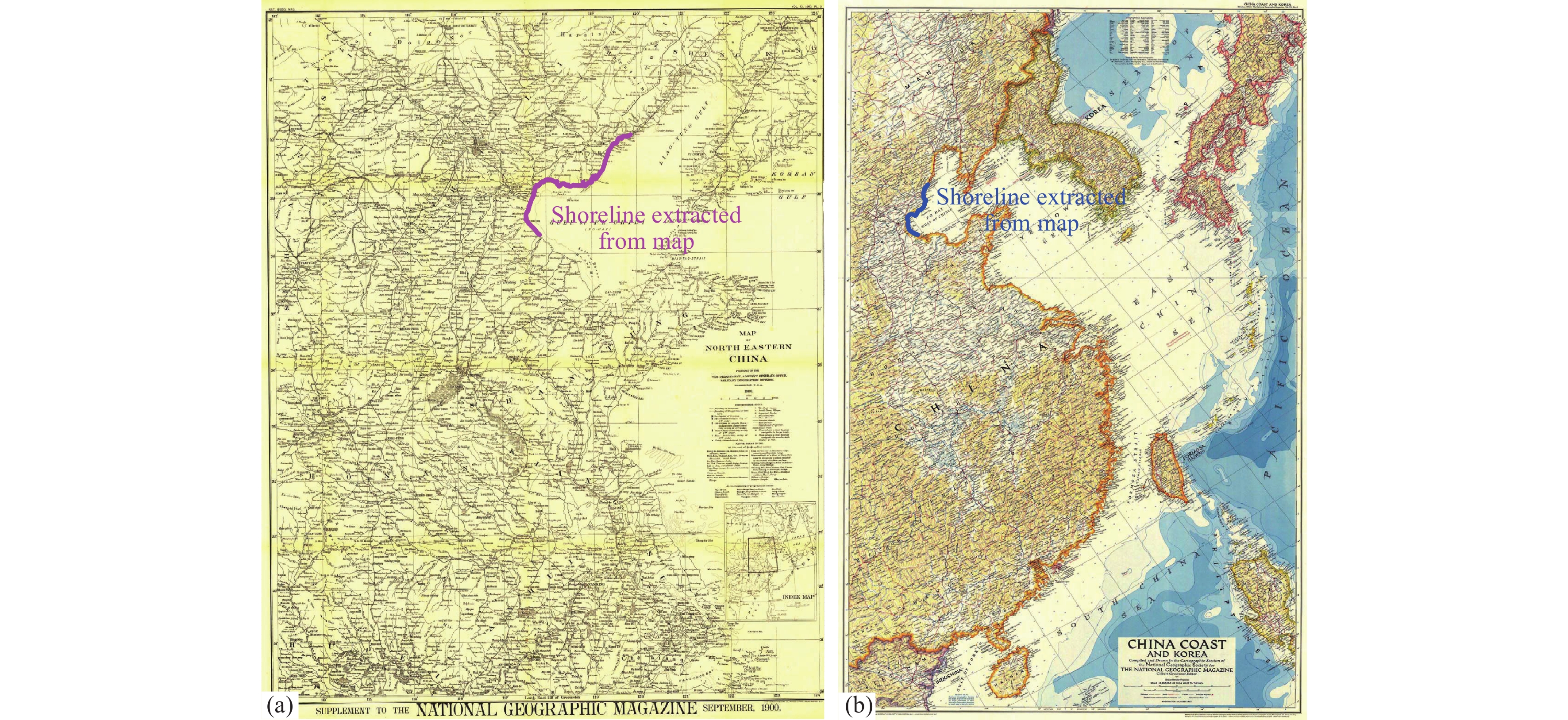
Maps of China published in 1900 and 1950, coupled with extracted shoreline locations; a–map of North Eastern China published in 1900 by the Military Information Division of USA; b–map of China coast and Korea compiled in 1950 by the National Geographic Society, USA.
-
Figure 3.
Satellite maps, extracted from Landsat OLI remote sensing data set and coupled with extracted shoreline locations; a–map photographed in 2000; b–map photographed in 2020.
-
Figure 4.
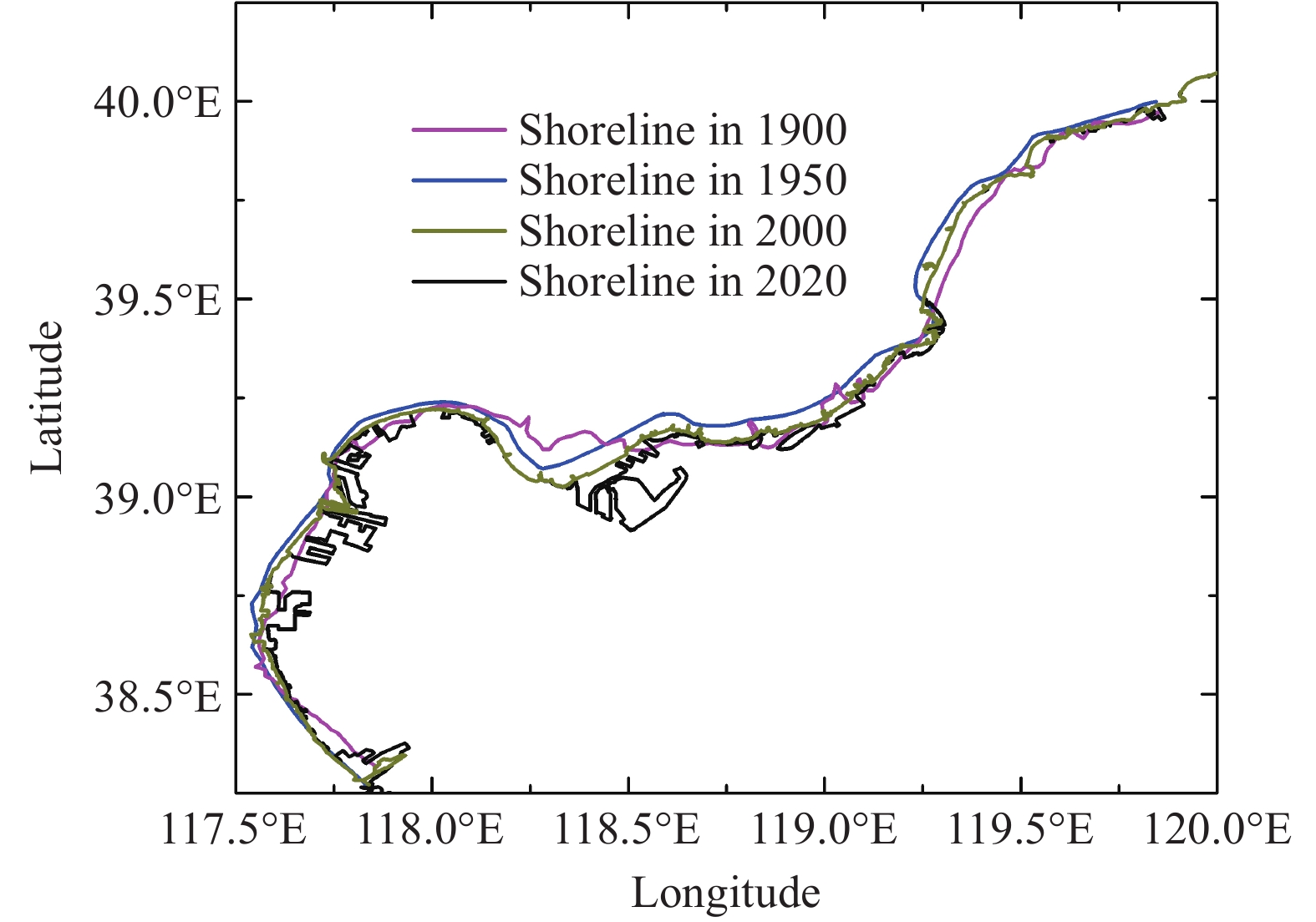
Four periods of shoreline location extracted from collected maps.
-
Figure 5.
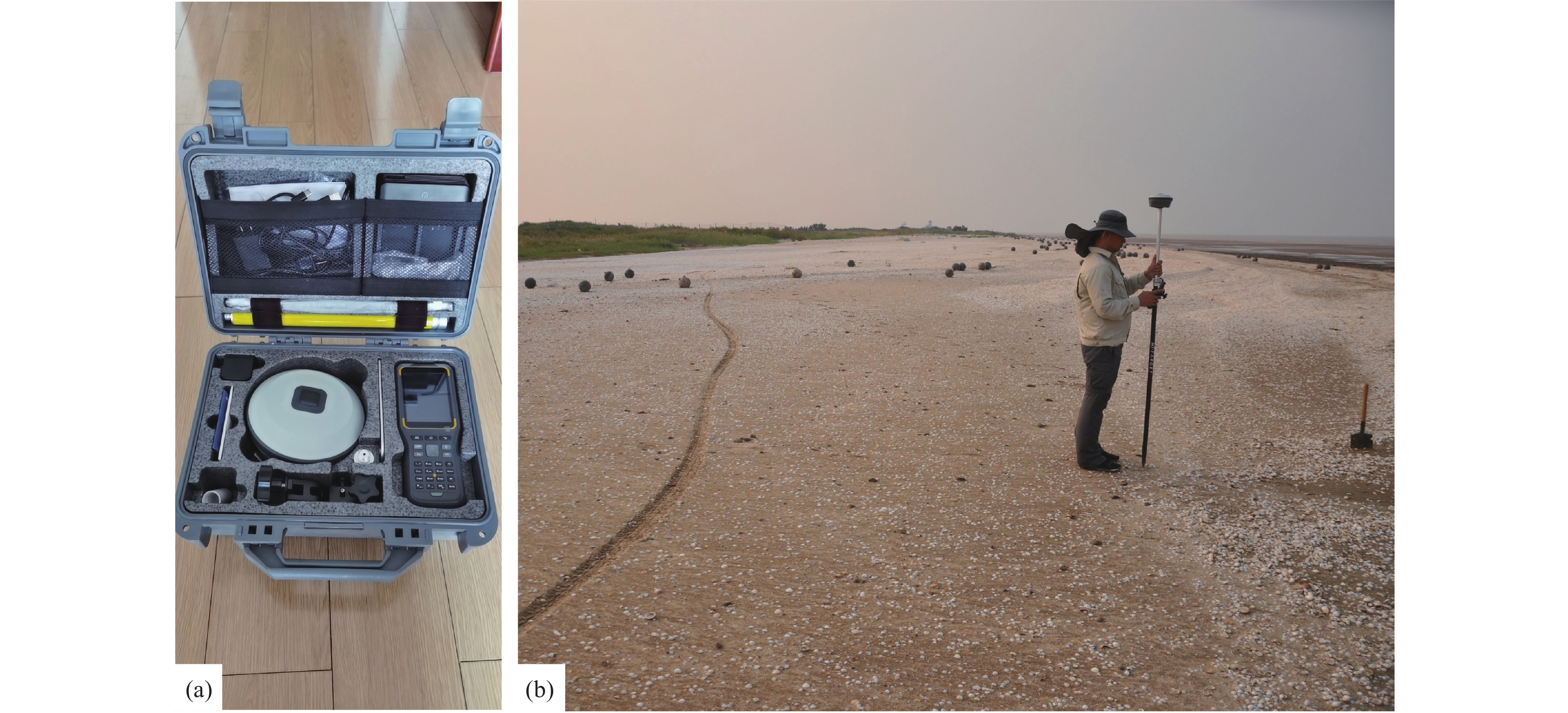
Field measurement for elevation of the tidal flat; a–measuring instrument (iRTK5); b–field measurement.
-
Figure 6.
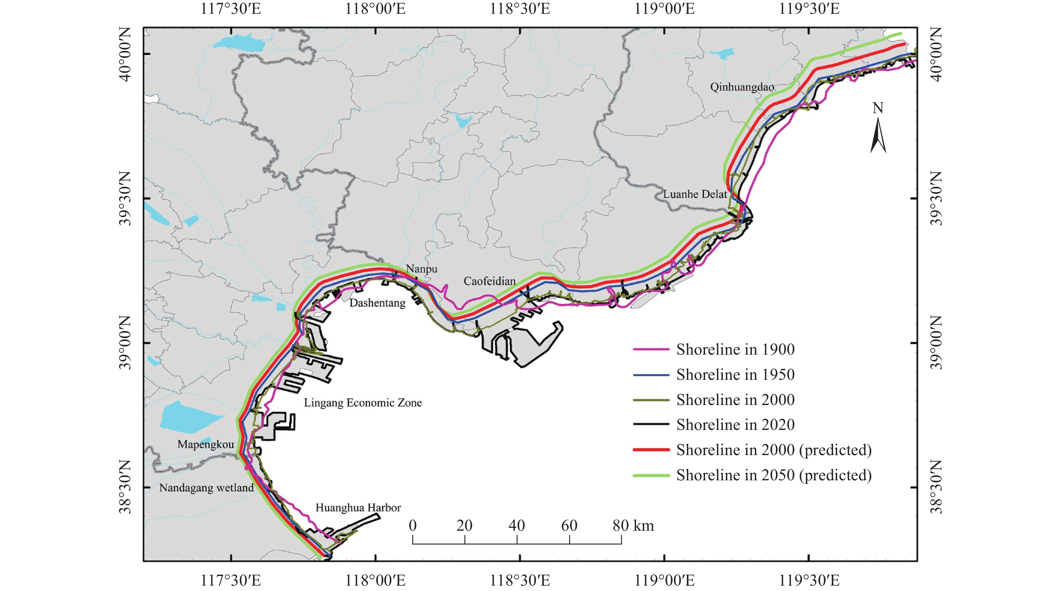
Comparison of past, present and expected future shoreline locations.
-
Figure 7.
Elevation measurements of tidal flat for three survey lines; a–north line located in Bohai Bay; b–central line located in west of Bohai Bay; c–south line located in Bohai Bay.
-
Figure 8.
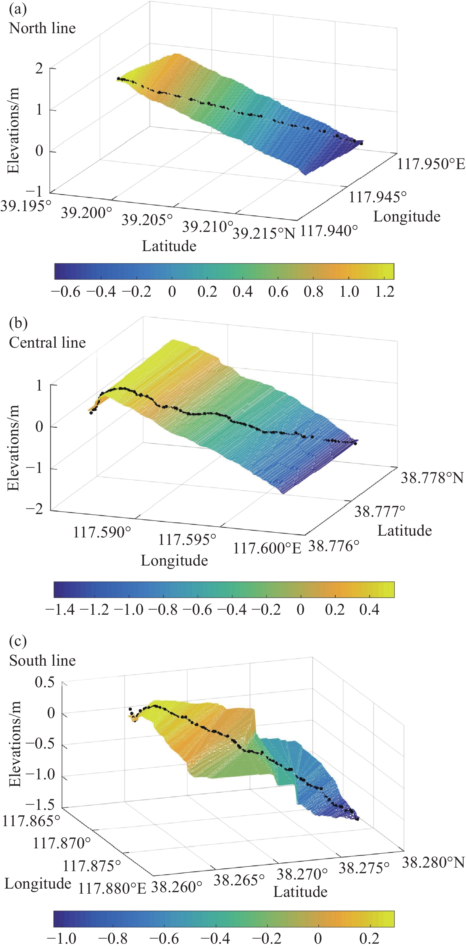
Contour map using IDW method for the second elevation of tidal flat
-
Figure 9.
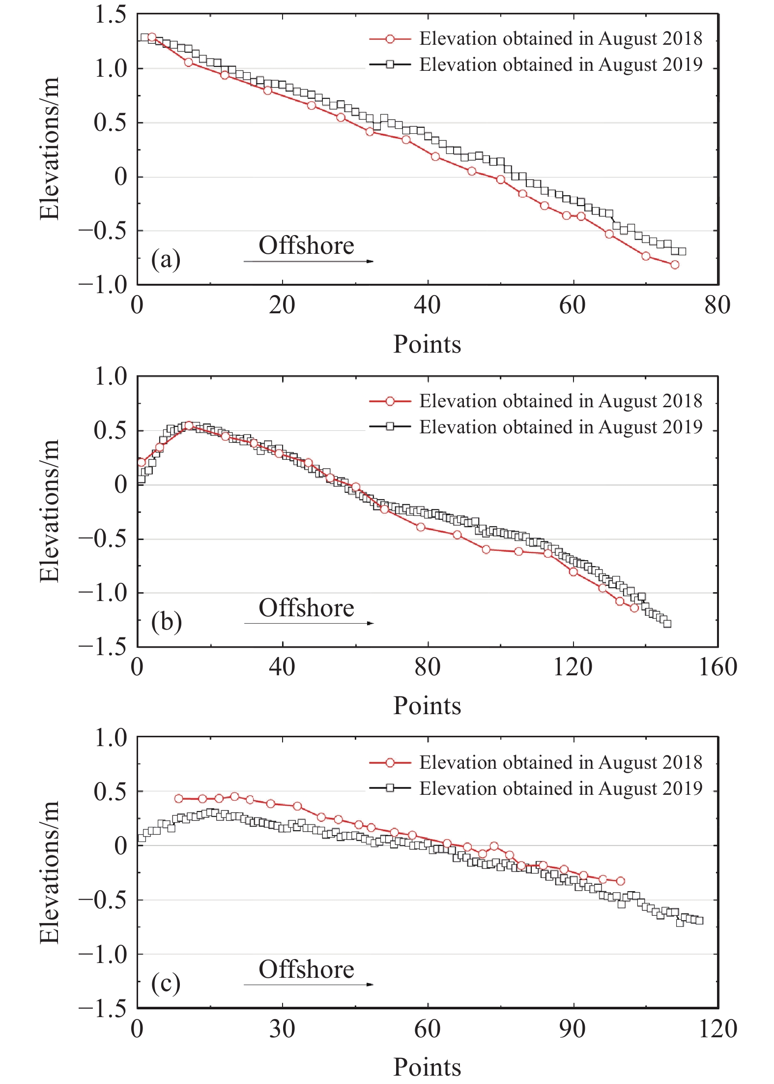
Comparison of the two elevation measurements for tidal flat; a–north line located in Bohai Bay; b–central line located in west of Bohai Bay; c–south line located in Bohai Bay.
-
Figure 10.
Present and expected future elevations for the next 10 years based on the linear regression model; a–north line located in Bohai Bay; b–central line located in west of Bohai Bay; c–south line located in Boahi Bay.
-
Figure 11.
Tidal flat in coastal area of Dashentang.
-
Figure 12.
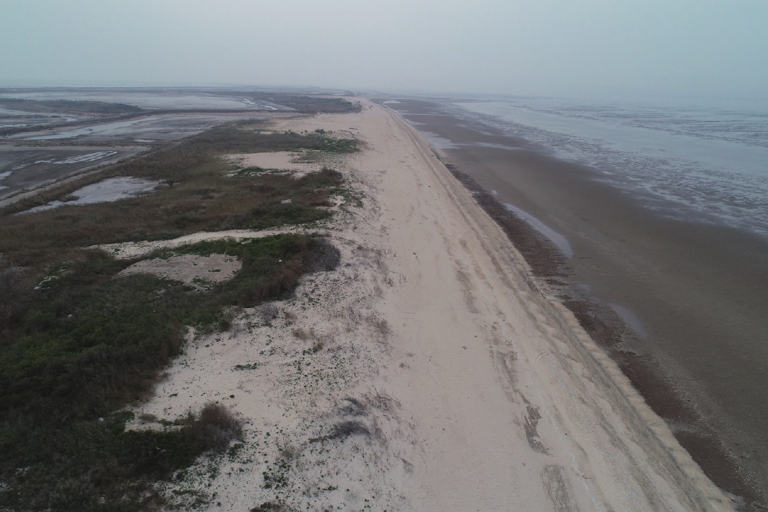
Aerial photograph of shell chenier in Binzhou Shell Dike Islands.



 DownLoad:
