| Citation: | Lakhlifa Benaissi, Amraoui Tarek, Adnane Tobi, Hassan Ibouh, Khadra Zaid, Khalid Elamari, Mohamed Hibti, 2022. Geological mapping and mining prospecting in the Aouli inlier (Eastern Meseta, Morocco) based on remote sensing and geographic information systems (GIS), China Geology, 5, 614-629. doi: 10.31035/cg2022035 |
Geological mapping and mining prospecting in the Aouli inlier (Eastern Meseta, Morocco) based on remote sensing and geographic information systems (GIS)
-
Abstract
Landsat 8 Oli, ASTER, and Sentinel 2A satellite images processing was used to map geological formations, lineaments and hydrothermal alteration minerals in the Aouli inlier, as a case study to illustrate the application of digital images processing and Geographic Information System (GIS) in geological mapping and mining prospecting. Principal Component Analysis (PCA) applied to the Landsat images allowed good lithological discrimination and contributed to the updating of available geological maps. The Automatic lineament extraction from Sentinel images revealed the main tectonic structures affecting Aouli inlier. The ratio bands (b5+b7)/b6 and the false color composite (b4/b6, b2/b1, b3/b2) allowed the hydrothermal alteration minerals mapping from Aster images. Combined with available geological data and field observations, the satellite derived data were integrated and analyzed in a GIS software to establish mining prospecting guides. The results showed that the anomaly zones are intimately linked to NNE–SSW and NW–SE oriented faults and to highly fractured areas developing argillic and Fe rich alterations. Verified via field survey, this approach was successfully applied to the Aouli inlier to rapidly target potential areas to be explored in the tactical phase. This provides a model for future prospecting efforts for similar mineral deposits in other areas.
-
Keywords:
- Remote sensing /
- GIS /
- Aouli inlier /
- Mining prospecting /
- Multi–criteria analysis
-

-
References
Abrams M. 2000. The advanced spaceborne thermal emission and reflection radiometer (ASTER): Data products for the high spatial resolution imager on NASA’s Terra platform. International Journal of Remote Sensing. Taylor & Francis, 21(5), 847–859. doi: 10.1080/014311600210326. Amade E. 1965. Les gisements de plomb de Zeïda et de Boumia. Colloque sur les gisements stratiformes de plomb, zinc et manganèse du Maroc. Notes et Mémoires. Service géologique. Maroc, 181, 175–184. Cengiz OY, Sener ER. 2019. Investigation of the Applicability of ASTER Satellite Images for Exploration of Barite Mineralization in the Bitlis Region. International Journal of Multidisciplinary Studies and Innovative Technologies, 3, 211–218. Dahire, MO. 2004. Le complexe plutonique de la Haute Moulouya (Meseta oriental, Maroc): Evolution pétrologique et structurale. Fès, Mohamed Ben Abdellah university, Ph. D thesis, 1–241 (in French with English abstract). Deslandes S, Gwyn Q H J. 1991. Evaluation de spot et seasat pour la cartographie des linéaments : Comparaison basée sur l’analyse de spectres de fourier. Canadian Journal of Remote Sensing. Taylor & Francis, 17(2), 98–110. doi: 10.1080/07038992.1991.10855284. Di Tommaso IN, Rubinstein NO. 2007. Hydrothermal alteration mapping using ASTER data in the Infiernillo porphyry deposit, Argentina. Ore Geology Reviews, 32, 275–290. doi: 10.1016/j.oregeorev.2006.05.004. Diot HE. 1989. Mise en place des granitoïdes hercyniens de la Meseta marocaine, Étude structurale des massifs de Sebt de Brikine (Rehamna), de Zaër et d’Oulmès (Massif Central) et d’Aouli–Boumia (Haute Moulouya) : Implications géodynamiques. Toulouse III, Paul Sabatier university, Ph. D thesis, 1–175 (in French with English abstract). Drusch M, Del Bello U, Carlier S, Colin O, Fernandez V, Gascon F, Hoersch B, Isola C, Laberinti P, Martimort P, Meygret A, Spoto F, Marchese O. Sy. F, Bargellini P. 2012. Sentinel–2: ESA’s Optical High–Resolution Mission for GMES Operational Services. Remote Sensing of Environment, 120, 25–36. doi: 10.1016/j.rse.2011.11.026. Elabouyi MU, Dahire MO, Driouch YO, Duchêne ST, Kriegsman LE, Ntarmouchant AH, Kahou ST, Severac JE LU, Belkasmi MO, Debatb PI. 2019. Crustal anatexis in the Aouli–Mibladen granitic complex: A window into the middle crust below the Moroccan Eastern Variscan Meseta. Journal of African Earth Sciences, 154(March), 136–163. doi: 10.1016/j.jafrearsci.2019.03.006. El-Hadi HA, Tahiri AB, Reddad AI. 2003. Les granitoïdes hercyniens post–collisionnels du Maroc oriental: Une province magmatique calco–alcaline à shoshonitique. Comptes. Rendus de. Géoscience, 335, 659–967 (in French with English abstract). Emberger A. 1965. Caractères polygénétiques des minéralisations plombifères de la haute Moulouya (gisements d'Aouli, de Mibladen et de Zeïda, Maroc). Comptes Rendus de l’Académie des Sciences, 260(12), 3433–3436 (In French with English abstract). Emberger A. 1965a. Caractères polygénétiques des minéralisations plombifères de la Haute Moulouya (gisements d’Aouli, Mibladen et Zeïda, Maroc). Chronique de la Recherche. Académique. Scientifique. Paris, t. 260. Groupe 9 (a), 3433–3436 (in French with English abstract). Emberger A. 1965b. Introduction à l’étude des minéralisations plombifères de la Haute Moulouya. Notes Mém. Serv. géol. Maroc, 181(b), 167–174 (in French with English abstract). ERDAS (Firm). 2007. ERDAS Field Guide. Leica Geosystems GIS & Mapping. Atlanta, Georgia, 1–619. Filali FO, Guiraux MI, Burg JE PI. 1999. Données pétro–structurales sur la boutonnière d’Aouli. Bulletin de la Société Géologique de France, 170(4), 435–450 (in French with English abstract). Fu BI, Shi PI, Fu HA, Ninomiya YO, Du JI. 2019. Geological Mapping Using Multispectral Remote Sensing Data in the Western China. IGARSS–IEEE International Geoscience and Remote Sensing Symposium, 5583–5586. doi: 10.1109/IGARSS.2019.8898880. Ganzeev A, Grouzdev V, Mitiaev A. 1978. Structure géologique de la région de la Haute Moulouya. Mines, Géologie et Energie, Rabat, 44(a), 111–114 (in French with English abstract). Guha AR, Vinod Kumar KU. 2016. New ASTER derived thermal indices to delineate mineralogy of different granitoids of an Archaean Craton and analysis of their potentials with reference to Ninomiya’s indices for delineating quartz and mafic minerals of granitoids–An analysis in Dharwar Cr. Ore Geology Reviews, 74, 76–87. doi: 10.1016/j.oregeorev.2015.10.033. Kruse FA, Boardman JW, Huntington JF. 2003. Comparison of Airborne Hyperspectral Data and EO–1 Hyperion for Mineral Mapping. IEEE Transactions on Geoscience and Remote Sensing, 41(6), 1388–1400. doi: 10.1109/TGRS.2003.812908. Hoepffner CH. 1987. La tectonique hercynienne dans l’Est du Maroc. Sciences de la Terre. Strasbourg, Louis Pasteur university, Ph. D thesis, 1–145 (in French with English abstract). Hoepffner CH. 1994. La zone Midelt-Tazekka Bsabis, le domaine interne de la chaîne varisque et ses relations avec le Massif hercynien central. Bulletins de l’Institut Scientifique, Rabat, 18, 169–191 (in French with English abstract). Jébrak MI, Marcoux ER, Nasloubi MO, Zaharaoui MO. 1998. From sandstone– to carbonate hosted stratabound deposits: An isotope study of galena in the Upper–Moulouya district (Morocco). Mineralium Deposita, 33(33), 406–415. doi: 10.1007/s001260050158. Jébrak MI. 2008. Géologie des ressources minérales. Québec: Ministère des Ressources Naturelles et de la Faune. Denis L. Lefebvre, ing, 1–673. ISBN: 9781897095737 (in French with English abstract). Margoum DA, Bouabdellah MO, Klügel AN, Banks A DA, Castorina FR, Cuney MI, Jébrak MI, Bozkayah GU. 2015. Pangea rifting and onward pre-Central Atlantic opening as the main ore-forming processes for the genesis of the Aouli REE-rich fluorite-barite vein system, Upper Moulouya District, Morocco. Journal of African Earth Sciences, 108, 22–39. doi: 10.1016/j.jafrearsci.2015.03.021. Naji MO. 2004. Les minéralisations plombo barytiques du district de la Haute Moulouya. Contexte géologique, contrôle tectonique et modèle de mise en place: Gisements d’Aoul–Mibladen–Zeïda. Rabat, Mohammed V University, Ph. D thesis, 1–145 (in French with English abstract). Pour AM BE, Hashim MA. 2014. Hydrothermal alteration mapping using Landsat–8 data, Sar Cheshmeh copper mining district, SE Iran. Journal of Taibah University for Science, 9. doi: 10.1016/j.jtusci.2014.11.008. Pournamdari MO, Hashim MA, Pour AM BE. 2014. Spectral transformation of ASTER and Landsat TM bands for lithological mapping of Soghan ophiolite complex, south Iran. Advances in Space Research, 54(4), 694–709. Raddi YO, Aarar MO, Michard AN. 2013. Carte géologique du Maroc Echelle 1/50000: Mibladen. Notes Mémoires Service géologique Maroc. Raddi YO, Essarraj SA, Michard AN. 2011. Le district plombifère de la Haute Moulouya (Aouli–Mibladen, Zeïda). Notes Mémoires Service géologique Maroc, 564, 81–86. Rhinane HA. 1990. Evolution tectonique et métamorphique de la boutonnière de Midelt. Rabat, Mohammed V university, Ph. D thesis, 1–125 (in French with English abstract). Roy D, Wulder M, Loveland T, Woodcock C, Allen R, Anderson M, Helder D, Irons J, Johnson D, Kennedy R, Scambos T, Schaaf C, Schott J, Sheng Y, Vermote E, Belward A, Bindschadler R, Cohen W, Gao F, Hipple J, Hostert P, Huntington J, Justice C, Kilic A, Kovalskyy V, Lee Z, Lymburner L, Masek J, McCorkel J, Shuai Y, Trezza R, Vogelmann J, Wynne R, Zhu Z. 2014. Landsat–8: Science and product vision for terrestrial global change research. Remote Sensing of Environment, 145, 154–172. doi: 10.1016/j.rse.2014.02.001. Scanvic JE. 1993. Télédétection aérospatiale et informations géologiques. Orléans: Ed. BRGM (Manuels et méthodes), 284 (in French with English abstract). Siamak Kh, Cynthia VA DE WI, Frank KO, Stacy NE, Matthew PO. 2016. Principles of Applied Remote Sensing. Springer, Cham, 1–307. doi: 10.1007/978-3-319-22560-9. Van der Meer FR, Van der Werff HA, Van Ruitenbeek FR, Hecker CH, Bakker WI, Noomen WA, Van der Meijde MA, Carranza JO, De Smeth BO, Woldai TS. 2012. Multi- and hyperspectral geologic remote sensing: A review. International Journal of Applied Earth Observation and Geoinformation, 14(1), 112–128. doi: 10.1016/j.jag.2011.08.002. Volesky JO, Stern RO, Johnson PE. 2003. Geological control of massive sulfide mineralization in the Neoproterozoic Wadi Bidah shear zone, southwestern Saudi Arabia, inferences from orbital remote sensing and field studies. Precambrian Research, 123(2), 235–247. doi: 10.1016/S0301-9268(03)00070-6. Wadjinni A, 1997. Le district à plomb–zinc de Touissit : Présentation gîtologique et synthèse des travaux réalisés. Notes et Mémoires Service géologique Maroc, 388, 151–164. Wahi MO, Kamal TA, Laftouhi NO. 2013. ASTER VNIR & SWIR B and Enhancement for Lithological Mapping: A case study of the Azegour Area (Western High Atlas, Morocco). Journal of Environment and Earth Science, 3(12), 33–44. -
Access History

-
Figure 1.
Geological map of Aouli inlier (Margoum DA, 2015; Emberger A, 1965a, 1965b).
-
Figure 2.
Geologic cross section NW–SE of Aouli inlier (Margoum DA, 2015. modified from Emberger A, 1965a, 1965b).
-
Figure 3.
Flowchart of the methodology for processing satellite images.
-
Figure 4.
PCA-derived image (RGB: PC1, PC2 and PC4) with overlaid geological vector layers (Lithological boundary in white). Sc1–Schists; Sc2–Hornfels; Gr1–Aouli granite; Gr2–El Hassir granitoid; Gr3–Biotite and muscovite granite; T1–Triassic Claystone; T2–Basalt; J–J2–Jurassic. C1–C2–Cretaceous.
-
Figure 5.
Updated Geological map of Aouli inlier resulting from remote sensing interpretation, field survey and archive data (after Margoum DA, 2015).
-
Figure 6.
Lineament map of the study area.
-
Figure 7.
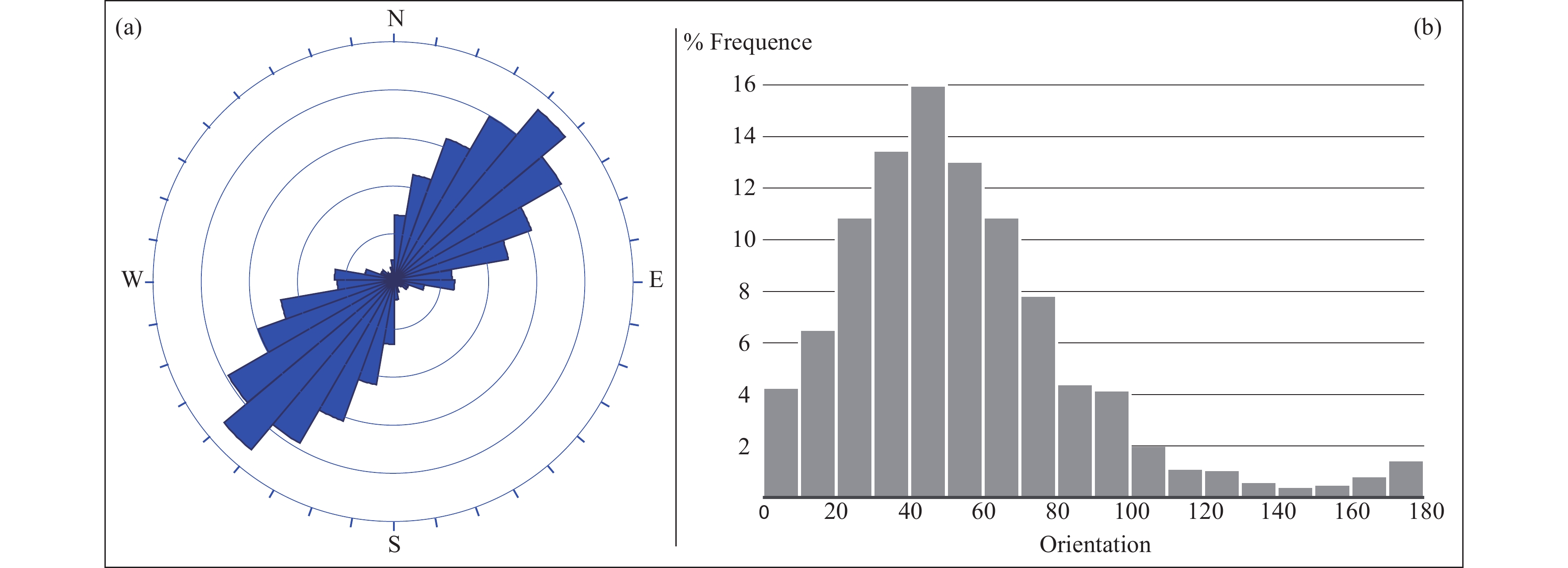
Lineament orientations in the basement; a–Rosacea of lineament orientations with an interval of 10°; b–frequency of lineament orientations (interval of 10°).
-
Figure 8.
Lineaments density map.
-
Figure 9.
Map of lineaments superposed to faults from data archive.
-
Figure 10.
a–Lineament in the schist extracted from ACP5; b–schistosity trajectories (after Filali FO et al., 1999).
-
Figure 11.
a–Schists; b–N30 fault; c–N45 fault zone; d–barite vein in the boundary between Palaeozoic schist and Triassic clay stones; e–rosacea of fractures measured in the field.
-
Figure 12.
a–Subvertical Barite vein hosted in schist; b–Ba vein showing surface oxidation; c, g–mineralogy of the mineralization. Brt–barite; Gn–galena; Qtz–quartz; Fl–fluorite; Py–pyrite; Ccp–chalcopyrite; Mlc–malachite; Az–azurite; (h)–sample from the oxidation zone with goethite (Ght) and limonite (Lm).
-
Figure 13.
Gossan ratio (b4/b2) highlighting Fe rich zones.
-
Figure 14.
Aster (b5+b7)/b6 ratio highlighting Alunite, Kaolinite, Pyrophyllite rich zones.
-
Figure 15.
ASTER hydrothermal component image (RGB: b5/b7, b3/b1 and b4/b3).
-
Figure 16.
Superposition of the lineament and mineral alteration maps.
-
Figure 17.
Superposition of ASTER hydrothermal image (RGB: b5/b7, b3/b1 and b4/b3) with ore veins.


 DownLoad:


