
| Citation: |
Wen-peng Li, Long-feng Wang, Yi-long Zhang, Li-jie Wu, Long-mei Zeng, Zhong-sheng Tuo, 2021. Determining the groundwater basin and surface watershed boundary of Dalinuoer Lake in the middle of Inner Mongolian Plateau, China and its impacts on the ecological environment, China Geology, 4, 498-508. doi: 10.31035/cg2021066

|
Determining the groundwater basin and surface watershed boundary of Dalinuoer Lake in the middle of Inner Mongolian Plateau, China and its impacts on the ecological environment
-
Abstract
The surface watershed and groundwater basin have fixed recharge scale, which are not only the basic unit for hydrologic cycle research but also control the water resources formation and evolution and its corresponding eco-geological environment pattern. To accurately identify the boundary of the surface watershed and groundwater basin is the basis for properly understanding hydrologic cycle and conducting the water balance analysis at watershed scale in complicated geologic structure area, especially when the boundary are inconsistent. In this study, the Dalinuoer Lake located in the middle of the Inner Mongolian Plateau which has complicated geologic structure was selected as the representative case. Based on the multidisciplinary comprehensive analysis of topography, tectonics, hydrogeology, groundwater dynamics and stable isotopes, the results suggest the following: (1) The surface watershed ridge and groundwater basin divide of Dalinuoer Lake are inconsistent. The surface watershed was divided into two separate groundwater systems almost having no groundwater exchange by the SW-NE Haoluku Anticlinorium Fault which has obvious water-blocking effect. The surface drainage area of Dalinuoer Lake is 6139 km2. The northern regional A is the Dalinuoer Lake groundwater system with an area of 4838 km2, and the southern regional B is the Xilamulun Riverhead groundwater system with an area of 1301 km2. (2) The groundwater in the southern of regional A and the spring-feeding river are the important recharge sources for the Dalinuoer Lake, and it has greater recharge effects than the northern Gonggeer River system. (3) It is speculated that the trend of Haoluku Anticlinorium Fault is the boundary of the westerlies and the East Asian summer Monsoon (EASM) climate systems, which further pinpoints the predecessor’s understanding of this boundary line. At present, the Dalinuoer Lake watershed is proved to have gone through a prominent warming-drying trend periods, which leads to the precipitation reduction, temperature rise, human activities water usage increasement. So the hydrological cycle and lake eco-environment at watershed scale will still bound to be change, which may pose the potential deterioration risk on the suitability of fish habitat. The results can provide basic support for better understanding water balance evolution and lake area shrinkage cause as well as the ecological protection and restoration implementation of Dalinuoer Lake watershed.
-

-
References
An CB, Chen FH. 2009. The pattern of Holocene climate change in the arid central Asia: A case study based on lakes. Journal of Lake Science, 21(3), 329–334 (in Chinese with English abstract). doi: 10.18307/2009.0303. Chen FH, Chen JH, Holmes J, Boomer I, Austin P, Gates JB, Wang NL, Brooks SJ, Zhang JW. 2010. Moisture changes over the last millennium in arid central Asia: A review, synthesis and comparison with monsoon region. Quaternary Science Reviews, 29(7–8), 1055–1068. doi: 10.1016/j.quascirev.2010.01.005. Gan TY. 2000. Reducing vulnerability of water resources of Canadian Prairies to potential droughts and possible climatic warming. Water Resources Management, 14(2), 111–135. doi: 10.1023/A:1008195827031. Geng K, Zhang ZC. 1988. The Geomorphic characteristics and evolution of the lakes in dalainuoer area of neimenggu plateau during the Holocene. Journal of Beijing Normal University (Natural Science), 4, 94–101 (in Chinese with English abstract). Inner Mongolia Autonomous Region 101 Geological Team. 1979. The 1∶200000 regional hydrogeological survey report of K-50-3 map sheet (in Chinese). Jiang MY, Han ZY, Li XS, Wang Y, Stevens, T, Cheng J, Lü CJ, Zhou YW, Yang QQ, Xu ZW. 2020. Beach ridges of Dali Lake in Inner Mongolia reveal precipitation variation during the Holocene. Journal of Quaternary Science, 35(5), 716–725. doi: 10.1002/jqs.3195. Li WB, Liu ZJ, Yang X, Li CY. 2019. Changes of stable oxygen and hydrogen isotopes in summer Dali-nor Lake in Inner Mongolia of Northern China. Journal of Lake Science, 31(2), 539–550 (in Chinese with English abstract). doi: 10.18307/2019.0222. Li WB, Li CY, Jia DB, Hao SQ, Liu ZJ, Li RZ. 2017. Change of stable isotopes in summer precipitation in central Inner Mongolia. Arid Zone Research, 34(6), 1214–1221 (in Chinese with English abstract). Li WP, Hao AB. 1999. The formation and evolution models of groundwater in the inland arid basin of northwestern China and its significance. Hydrogeology & Engineering Geology, (04), 30–34 (in Chinese with English abstract). Li WP, Hao AB, Zheng YJ, Liu B, Yu DS. 2006. Regional environmental isotopic features of groundwater and their hydrogeological explanation in the Tarim Basin. Earth Science Frontiers, 13(1), 191–198 (in Chinese with English abstract). Li WP, Zhou CH, Zhou YX, Jiao PX, Hao AB. 1995. Groundwater flow system in typical arid area of northwest China. Beijing: Seismological Press. ISBN: 9787502813062 (in Chinese) Ma C, Liu WW, Zhao PF, Ma WS, Ma W. 2017. Wetland and grassland egradation and the response to climate in Dalinor Basin duing 1962–2016. Geographical Research, 36(9), 1755–1772 (in Chinese with English abstract). Muxi YL, Qin FY, Burenjiregala, Narenmandula, Guo EL, Yi BL. 2020. Dynamic changes and driving factors of water area in Dalinor nature eeserve, Inner Mongolia, 1983–2018. Chinese Agricultural Science Bulletin, (32), 62–68 (in Chinese with English abstract). Wang WX, An YH, Li WP, Shao XM, Wu X, Gong L, Zhang MN, Wang XY, Cai YM. 2016.Groundwater flow system analysis of the Zhangye basin based on environmental isotope techniques. Hydrogeology & Engineering Geology, 43(02), 25–30 (in Chinese with English abstract). Xing ZQ, Huang HJ, Li YY, Liu SS, Wang D, Yuan Y, Zhao ZN, Bu LS. 2021. Management of sustainable ecological water levels of endorheic salt lakes in the Inner Mongolian Plateau of China based on eco‐hydrological processes. Hydrological Processes, 35(5). Yang FY, Wen BL, Li XY, Yang YL, Wan S, Ouyang L, Liu WH, Wang ZW, Meng XP, Li CX, Alamus. 2020. Investigation of water environment and fish diversity in Dalinor wetlands Ⅱetalkalinity, pH and hardness of the water of Dali Lake. Wetland Science, 18(6), 646–652 (in Chinese with English abstract). Yang XP, Scuderi LA, Wang XL, Scuderi LJ, Zhang DG, Li HW, Forman S, Xu QH, Wang RC, Huang WW, Yang SX. 2015. Groundwater sapping as the cause of irreversible desertification of Hunshandake Sandy Lands, Inner Mongolia, northern China. Proceedings of the National Academy of Sciences of the United States of America 112(3), 702–706. doi: 10.1073/pnas.1418090112. Zhen ZL, Li CY, Li WB, Hu QT, Liu XX, Liu ZJ, Yu RX. 2014. Characteristics of environmental isotopes of surface water and groundwater and their recharge relationships in Lake Dali basin. Journal of Lake Science, 26(6), 916–922 (in Chinese with English abstract). doi: 10.18307/2014.0614. Zhen ZL, Li WB, Xu LS, Zhang X, Zhang J. 2021 Lake-level variation of Dali Lake in mid-east of inner Mongolia since the Late Holocene. Quaternary International, 583, 62–69. doi: 10.1016/j.quaint.2021.03.003 Zhu BQ, Ren XZ, Rioual P. 2019. Geological control on the origin of fresh groundwater in the Otindag Desert, China. Applied Geochemistry, 103, 131–142. doi: 10.1016/j.apgeochem.2019.03.006. -
Access History

Figures(6)
Tables(1)

Export File
Citation
Wen-peng Li, Long-feng Wang, Yi-long Zhang, Li-jie Wu, Long-mei Zeng, Zhong-sheng Tuo, 2021. Determining the groundwater basin and surface watershed boundary of Dalinuoer Lake in the middle of Inner Mongolian Plateau, China and its impacts on the ecological environment, China Geology, 4, 498-508. doi: 10.31035/cg2021066
Format
Content
 DownLoad:


-
Figure 1.
Groundwater basin and surface watershed boundary as well as the collected water samplings sites from the scientific literature.
-
Figure 2.
Hydrogeological sketch map of the Dalinuoer Lake and Xilamulun Riverhead.
-
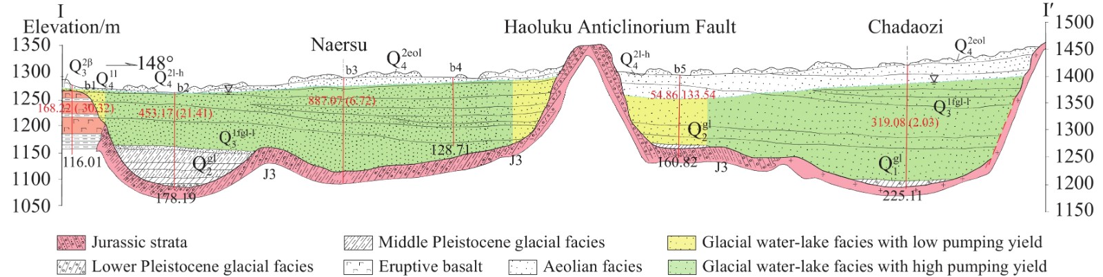
Figure 3.
I-I' hydrogeological profile map of the Dalinuoer Lake watershed.
-
Figure 4.
Isoline map of groundwater level elevation.
-
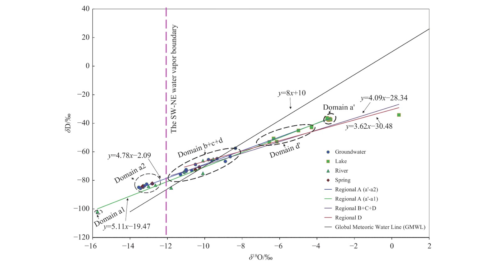
Figure 5.
Relations of δD and δ18O in all the water samplings.
-
Figure 6.
Relations of δD and δ18O in the water samplings collected from domain b+c+d.