
| Citation: |
Wen-hui Jie, Chun-lei Xiao, Ce Zhang, En Zhang, Jing-yue Li, Bing Wang, Hai-wei Niu, Shuang-fa Dong, 2021. Remote sensing-based dynamic monitoring and environmental change of wetlands in southern Mongolian Plateau in 2000‒2018, China Geology, 4, 353-363. doi: 10.31035/cg2021032

|
Remote sensing-based dynamic monitoring and environmental change of wetlands in southern Mongolian Plateau in 2000‒2018
-
Abstract
The environmental change in the wetlands in the southern Mongolian Plateau has important impacts on the environment of North China and even the entire Northeast Asia, from which the global climate change can be understood on a large scale, especially the climate change in the Mongolian Plateau. This study extracted the information on the wetlands from three stages of remote sensing images (also referred to as RS images) of the study area, including Enhanced Thematic Mapper Plus (ETM+) images of 2000, TM images of 2010, and Landsat 8 Operational Land Imager (OLI) images of 2018. As indicated by the extraction results, the area of wetlands decreased from 796.90 km2 of 2000 to 666.24 km2 of 2018 at a rate of 7.26 km2/a. The reduced area is 130.66 km2, which is about 16.4% reduction. And the patch number of wetlands decreased from 731 of 2000 to 316 of 2018 in the study area, approximately 56.8% reduction (415 patches), and the decrease in the area of the wetlands mainly occurred in the northwest endorheic region. In terms of wetland types, the change of the wetlands was dominated by the decrease of lacustrine wetlands, of which the area and patch number decreased by 106.2 km2 and 242, respectively. Furthermore, the area of the lacustrine wetlands decreased at the highest rate of 8.70 km2/a in 2010‒2018. From the perspective of spatial distribution, the wetlands in the western part shrunk more notably than those in the eastern part as a whole in the study area. According to local meteorological data, the precipitation gently decreased and the temperature increased (about 1.7℃) from 1975–2018. Overall, the decrease in the area of the wetlands and the temperature rises in the study area were mainly driven by the Mongolian monsoon climate, reduction in precipitation, and human activities.
-

-
References
Ai JQ. 2020. Long-term evolution process and mechanisms of wetland ecosystem in the Yangtze River estuary using time-series multi-sensor remote sensing data. Acta Geodaetica et Cartographica Sinica, 49(1), 133 (in Chinese with English abstract). doi: 10.11947/j.AGCS.2020.20190026. Cheng PG, Yu XJ, Zhong YF, He AL. 2018. Monitoring and analysis of 1987−2016 years’ area change in Shahu Lake of Wuhan City based on landsat images. Jiangxi Science, 36(3), 400–407 (in Chinese with English abstract). doi: 10.13990/j.issn1001-3679.2018.03.010. Davidson NC. 2018. Ramsar Convention on Wetlands: Scope and Implementation. Netherland, Springer, 451−458. Han M, Tian X, Meng H, Li XD. 2003. A research on establishing ecological information system of Zhalong Wetland based on GIS. Computer Engineering and Applications, 39(27), 230–232 (in Chinese with English abstract). Han M. 2012. Wetland Dynamic and Ecological Compensation Standard of the Yellow River Delta Based on Remote Sensing Images. Jinan, Shandong University, Doctoral thesis, 1−123(in Chinese with English abstract). doi: 10.7666/d.Y2263327. He Q, Xu LY. 2017. Preliminary discussion on the impact assessment of wetland ecological environment. Agriculture and Technology, 37(12), 12 (in Chinese with English abstract). doi: 10.11974/nyyjs.20170632012. Huang XY, Ye SY, Yuan HM, Ding XG, Zhao GM, Yang SX, He L, Wang J, Liu J, Pei SF, Han ZZ, Pei LX, Guo RS. 2019. Heavy metal distribution in the wetland sediments of the Liaohe delta: Implications for filter function of wetlands. Geological Bulletin of China, 38(2/3), 414–425 (in Chinese with English abstract). Jie WH, Zhang C, Cheng SS, Fu LH, Cheng X. 2020. Remote sensing monitoring of land use and ecological environment in Shihezi City in recent years. Geospatial Information, 18(1), 54–57, 72 (in Chinese with English abstract). doi: 10.3969/j.issn.1672-4623.2020.01.015. Li CL, Kuang RY, Wu QW. 2019. Analysis of information extraction and monitoring of Poyang Lake wetland during low flow period in recent ten years. Journal of Jiangxi University of Science and Technology, 40(3), 30–37 (in Chinese with English abstract). doi: 10.13265/j.cnki.jxlgdxxb.2019.03.005. Li HY, Zhang GX, Li XQ, Gao R, Deng CN. 2012. Water purification mechanism of zhalong wetland. Scientia Geographica Sinica, 32(1), 87–93 (in Chinese with English abstract). doi: 10.13249/j.cnki.sgs.2012.01.012. Li XF, Yao XJ, Sun MP, Gong P, An LN, Qi MM, Gao YP. 2018. Spatial-temporal variations in lakes in northwest China from 2000 to 2014. Acta Ecologica Sinica, 38(1), 96–104 (in Chinese with English abstract). doi: 10.5846/stxb201612262677. Lin J, Yan CG, Yuan J, Chen KL, Meng XM. 1997. A tentative idea on China wetland monitoring framework. Chinese Wildlife, 18(4), 12–14 (in Chinese with English abstract). doi: 10.19711/j.cnki.issn2310-1490.1997.04.004. Liu HM, Huangfu CH, Yang DL. 2010. Countermeasures of performance ramsar convention in China. Ecological Economy, 7, 167–169 (in Chinese with English abstract). Liu HT. 1995. Definition and clasification of wetlands. Chinese Journal of Ecology, 14(4), 73–77 (in Chinese with English abstract). doi: 10.13292/j.1000-4890.1995.0061. Luo JC, Sheng YW, Sheng ZF, Li JL, Gao LJ. 2009. Automatic and high-precise extraction for water information from multispectral images with the step-by-step iterative transformation mechanism. Journal of Remote Sensing, 13(4), 610–615 (in Chinese with English abstract). Mc Feeters SK. 1996. The use of normalized difference water index (NDWI) in the delineation of open water features. International Journal of Remote Sensing, 17(7), 1425–1432. doi: 10.1080/01431169608948714. Nie XR, Liu R, Nie AQ, Le HF, Tu RJ. 2018. The change map and dynamic monitoring of lake area in Nanchang City in recent 30 years. Geomatics & Spatial Information Technology, 41(8), 117–122 (in Chinese with English abstract). Sun N, Zhu WN, Cheng Q. 2017. Remote sensing time-series analysis of wetland variations and driving factors in estuarine and coastal regions of Yangtze River. Acta Scientiae Circumstantiae, 37(11), 4366–4373 (in Chinese with English abstract). doi: 10.13671/j.hjkxxb.2017.0283. Tian H, Jin HT, Sun QF, Liang XJ, Liu Q, Li XG. 2018. Ecolgical evaluation on Panjin wetland based on analytic hierarchy process. Geology and Resources, 27(3), 268–271, 287 (in Chinese with English abstract). doi: 10.13686/j.cnki.dzyzy.2018.03.009. Wang Y. 2019. Ecological environment monitoring of Wuliangsuhai wetland reserve. Regional Governance, 26, 82–85 (in Chinese with English abstract). Wu CD, Meng XM, Chu JY, Fu WG, He HJ, Meng XJ. 2005. Correlation between hydrological situation and vegetation in Mount Beigu wetland. Journal of Jiangsu University (National Science Edition), 26(4), 331–335 (in Chinese with English abstract). Xiao DR, Tian K, Yuan H, Li NY, Xu SG. 2007. Landscape diversity of Napahai wetland plant community in Northwest Yunnan of China. Chinese Journal of Ecology, 26(8), 1171–1176 (in Chinese with English abstract). doi: 10.13292/j.1000-4890.2007.0209. Xu ZG, He Y, Yan BX, Song CC. 2007. Niche characteristics of typical marsh wetland plant populations in Sanjiang Plain. Chinese Journal of Applied Ecology, 18(4), 783–787 (in Chinese with English abstract). doi: 10.13287/j.1001-9332.2007.0132. Yang QL. 2007. The Holocene East Asian Monsoon Record from Tenger Nuur of Monsoon Boundary in the Southern Mongolia Plateau. Lanzhou, Lanzhou University, Master’s thesis, 1-75. doi: 10.7666/d.Y1090069. Yin ZQ, Qin XG, Liu JQ, Qiu SW. 2006. Formation background of the Zhalong wetland and its eco-environmental significance. Progress in Geography, 25(3), 32–38, 138−139 (in Chinese with English abstract). Zhao R, Su XK, She WQ, Xu KP, Wei MY. 2019. Remote sensing monitoring of Dongting Wetland information based on LANDSAT Time Series Data. Environment and Development, 31(10), 128–129, 131 (in Chinese with English abstract). doi: 10.16647/j.cnki.cn15-1369/X.2019.10.070. Zhu H, Huang SF, Yang K, Li R. 2019. Remote sensing monitoring and analysis of the changes of Poyang Lake in the past 50 years. Satellite Application, 11, 29–35 (in Chinese with English abstract). Zhu YN, Li MG, Hu BQ, Zhai HY. 2019. Study on evolution of landscape pattern in middle and upper reaches of Fuhe River. Acta Agriculturae Jiangxi, 31(4), 112–116 (in Chinese with English abstract). doi: 10.19386/j.cnki.jxnyxb.2019.04.21. -
Access History

Figures(13)
Tables(7)

Export File
Citation
Wen-hui Jie, Chun-lei Xiao, Ce Zhang, En Zhang, Jing-yue Li, Bing Wang, Hai-wei Niu, Shuang-fa Dong, 2021. Remote sensing-based dynamic monitoring and environmental change of wetlands in southern Mongolian Plateau in 2000‒2018, China Geology, 4, 353-363. doi: 10.31035/cg2021032
Format
Content
 DownLoad:


-
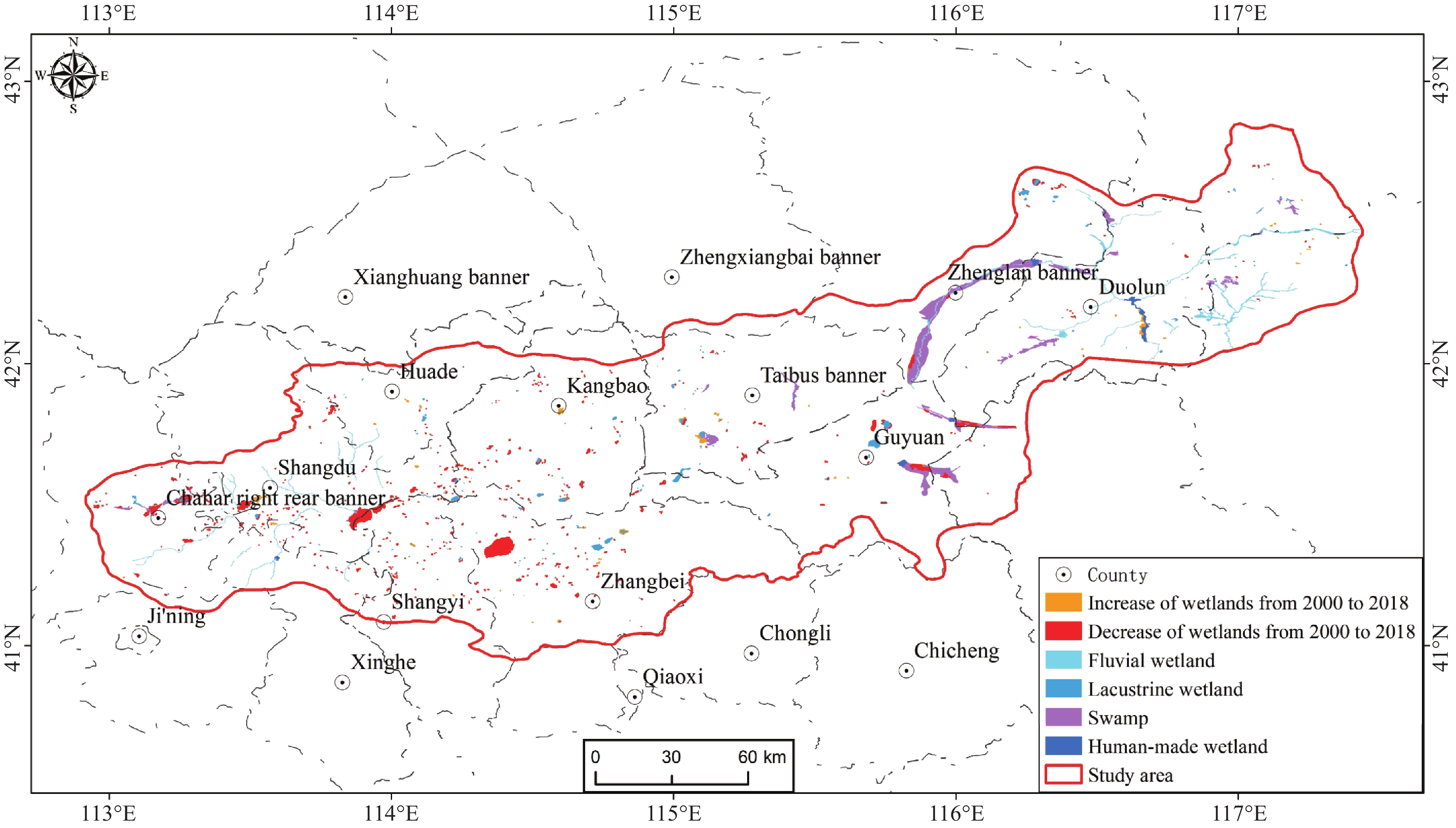
Figure 1.
Schematic map of the study area.
-
Figure 2.
Changes of the wetlands in the study area in 2000‒2010.
-
Figure 3.
Changes of the wetlands in the study area in 2010‒2018.
-
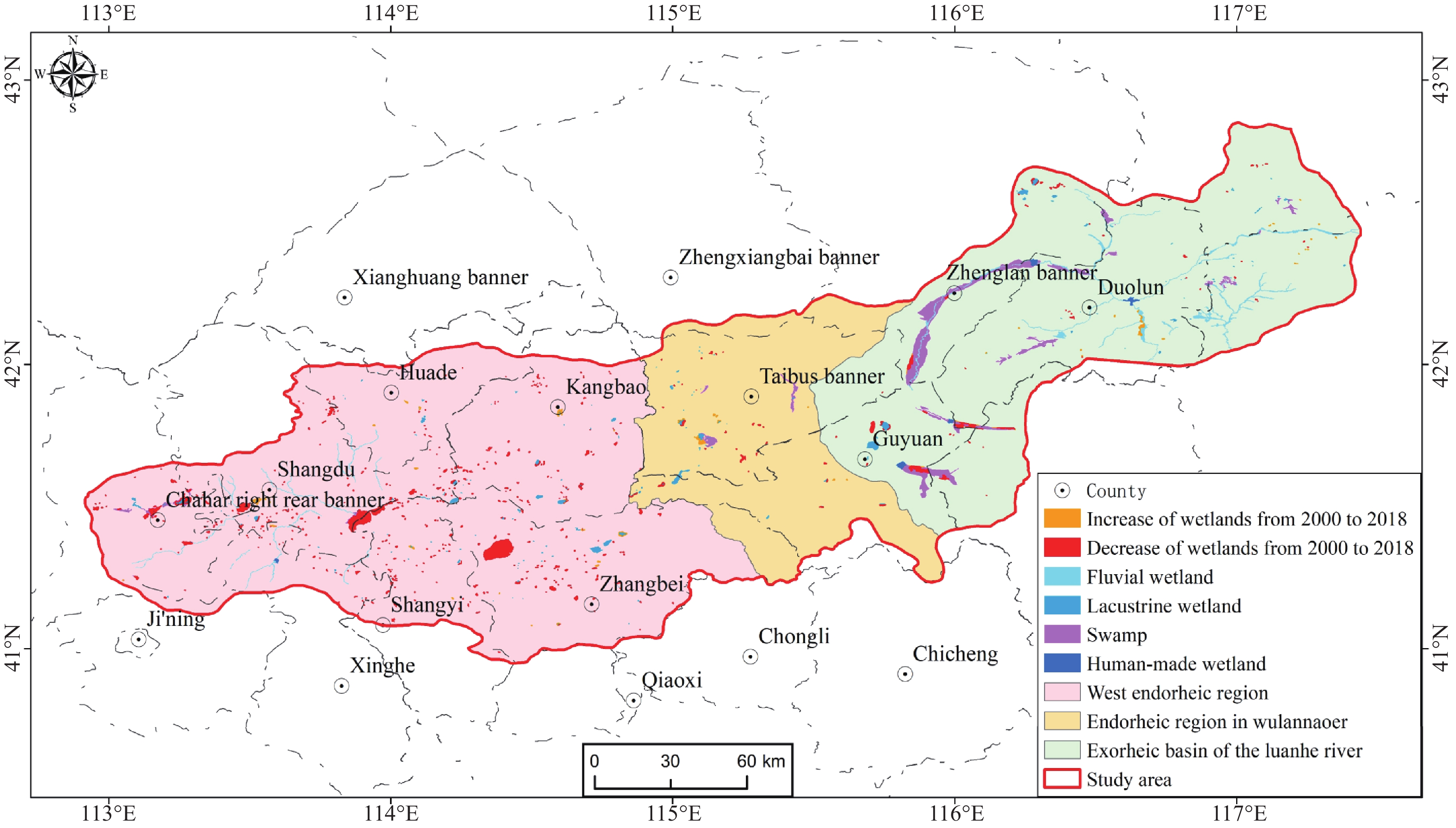
Figure 4.
Changes of the wetlands in the study area in 2000‒2018.
-
Figure 5.
Changes of the wetlands in different regions in the study area in 2000‒2018.
-
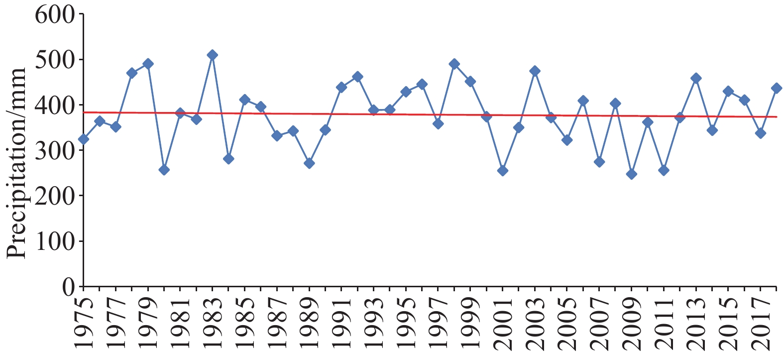
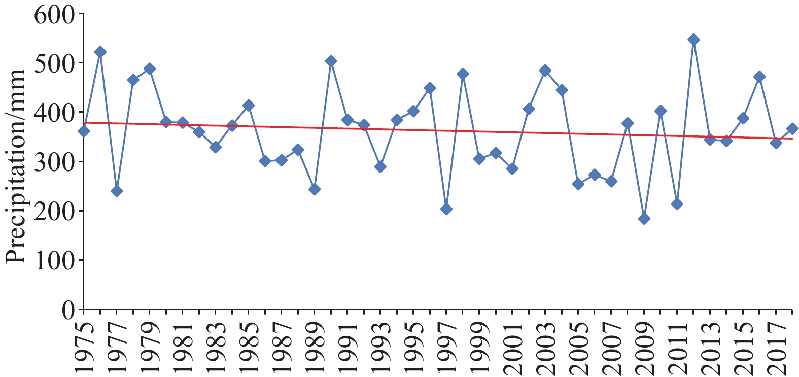
Figure 6.
Annual precipitation trend in 1975‒2018 monitored at Duolun station.
-
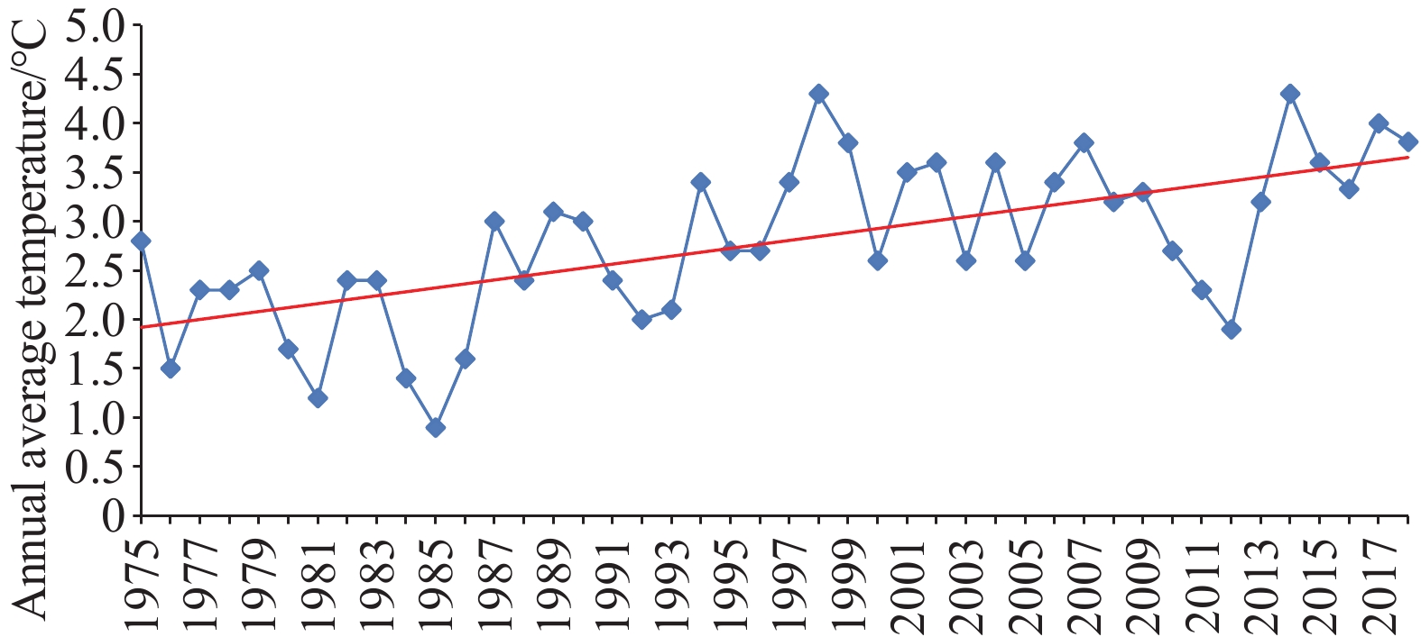
Figure 7.
Annual average temperature trend in 1975‒2018 monitored at Duolun station.
-
Figure 8.
Annual precipitation trend in 1975‒2018 monitored at Zhangbei station.
-
Figure 9.
Annual average temperature trend in 1975‒2018 monitored at Zhangbei station.
-
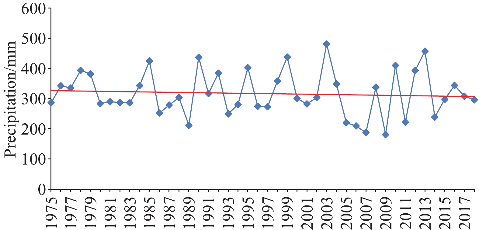
Figure 10.
Annual precipitation trend in 1975‒2018 monitored at Jining station.
-
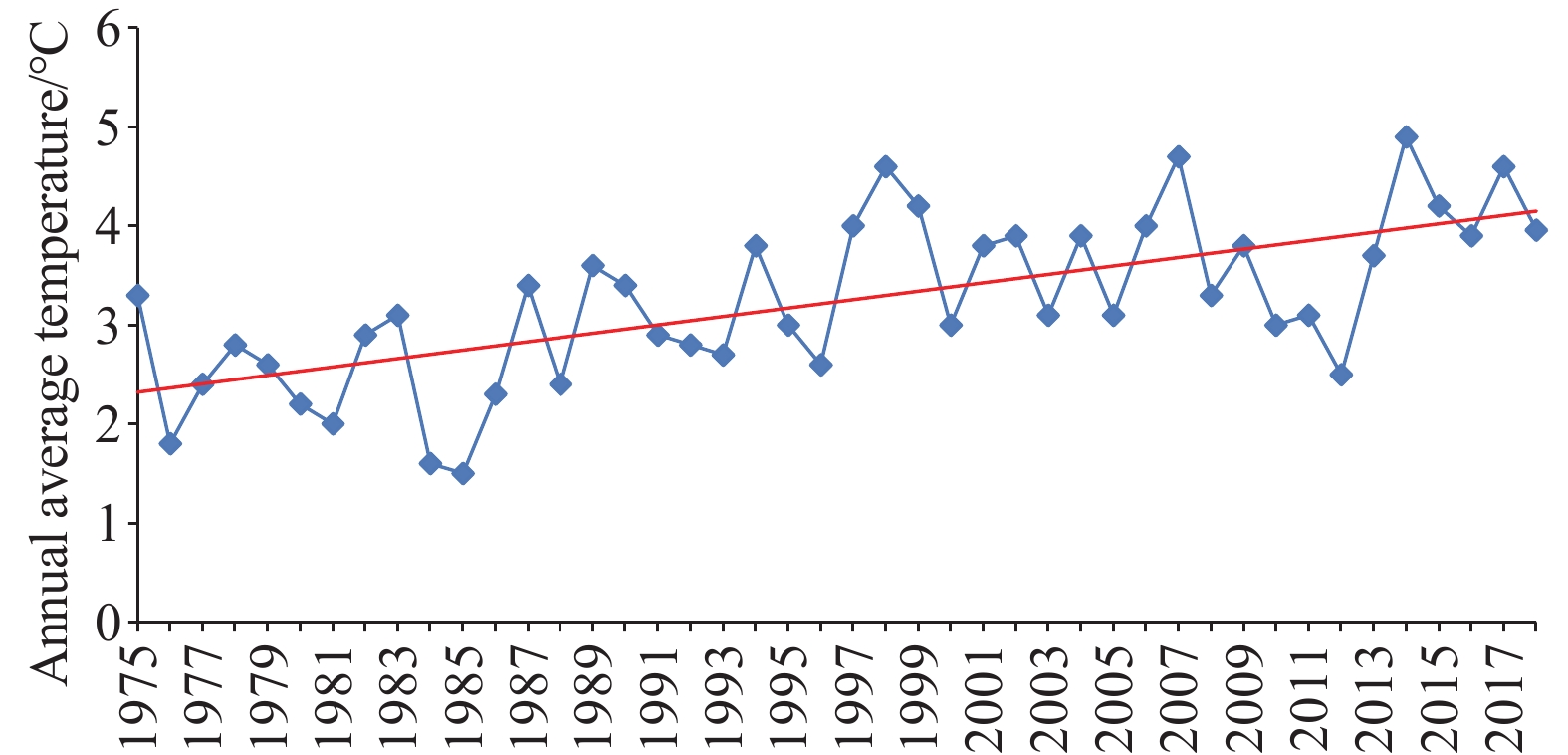
Figure 11.
Annual average temperature trend in 1975−2018 monitored at Jining station
-
Figure 12.
Annual precipitation trend in 1975‒2018 monitored at Huade station.
-
Figure 13.
Annual average temperature trend in 1975‒2018 monitored at Huade station.