| Citation: | Hui-qiang Yao, Yong-gang Liu, Yong Yang, Jin-feng Ma, Huo-Dai Zhang, Jiang-bo Ren, Xi-guang Deng, Gao-wen He, 2021. Assessment of acoustic backscatter intensity surveying on deep-sea ferromanganese crust: Constraints from Weijia Guyot, western Pacific Ocean, China Geology, 4, 288-298. doi: 10.31035/cg2020046 |
Assessment of acoustic backscatter intensity surveying on deep-sea ferromanganese crust: Constraints from Weijia Guyot, western Pacific Ocean
-
Abstract
Near-bottom observation data from the manned deep submersible Jiaolong with high-precision underwater positioning data from Weijia Guyot, Magellan Seamounts in the Western Pacific Ocean are reported. Three substrate types were identified: Sediment, ferromanganese crust, and ferromanganese crust with a thin cover of sediment. The ferromanganese crusts show clear zoning and their continuity is usually disturbed by sediments on areas of the mountainside with relatively gentle slope gradients. The identified substrate spatial distributions correspond to acoustic backscatter intensity data, with regions of high intensity always including crust development and regions of low intensity always having sediment. Therefore, acoustic backscatter intensity surveying appears useful in the delineation and evaluation of crust resources, although further more work is needed to develop a practicable methodology.
-

-
References
Ahmed KI, Demšar U. 2013. Improving seabed classification from multi-beam echo sounder (mbes) backscatter data with visual data mining. Journal of Coastal Conservation, 17(3), 559–577. doi: 10.1007/s11852-013-0254-3. Asavin AM, Kubrakova IV, Mel’nikov ME, Tyutyunnik OA, Chesalova EI. 2010. Geochemical zoning in ferromanganese crusts of Ita Maitai Guyot. Geochemistry International, 48(5), 423–445. doi: 10.1134/S0016702910050010. Chakraborty B, Kodagali V. 2004. Characterizing Indian Ocean manganese nodule-bearing seafloor using multi-beam angular backscatter. Geo-Marine Letters, 24(1), 8–13. doi: 10.1007/s00367-003-0153-y. Chakraborty B, Pathak D, Sudhakar M, Raju YS. 1997. Determination of nodule coverage parameters using multibeam normal incidence echo characteristics: A study in the Indian Ocean. Marine Georesources and Geotechnology, 15(1), 33–48. doi: 10.1080/10641199709379933. Cheng YS. 2014. Study of evaluation of Co-rich ferromanganese crust resources on seamounts in Northwest Pacific Ocean. Qingdao, Ocean University of China, Doctoral thesis, 1−144 (in Chinese with English Abstract). Cuff A, Anderson JT, Devillers R. 2015. Comparing surficial sediments maps interpreted by experts with dual-frequency acoustic backscatter on the Scotian Shelf, Canada. Continental Shelf Research, 110, 149–161. doi: 10.1016/j.csr.2015.10.004. de Moustier C. 1985. Inference of manganese nodule coverage from sea beam acoustic backscattering data. Geophysics, 50(6), 989–1001. doi: 10.1190/1.1441976. Dunlop KM, Jarvis T, Benoit-Bird KJ, Waluk CM, Caress DW, Thomas H, Smith KL. 2018. Detection and characterisation of deep-sea benthopelagic animals from an autonomous underwater vehicle with a multibeam echosounder: A proof of concept and description of data-processing methods. Deep Sea Research Part I: Oceanographic Research Papers, 134, 64–79. doi: 10.1016/j.dsr.2018.01.006. He GW, Liang DH, Song CB, Wu SG, Zhou JP, Zhang XH. 2005. Determining the distribution boundary of cobalt-rich crusts of guyot by synchronous application of sub-bottom profiling and deep-sea video recording. Earth Science-Journal of China University of Geosciences, 30(4), 509–512 (in Chinese with English abstract). He GW, Ma WL, Song CB, Yang SX, Zhu BD, Yao HQ, Jiang XX, Cheng YS. 2011. Distribution characteristics of seamount cobalt-rich ferromanganese crusts and the determination of the size of areas for exploration and exploitation. Acta Oceanologica Sinica, 30(3), 63–75 (in Chinese with English abstract). doi: 10.1007/sl3131-011-0120-9. Hein JR, Conrad TA, Dunham RE. 2009. Seamount characteristics and mine-site model applied to exploration- and mining-lease-block selection for cobalt-rich ferromanganese crusts. Marine Georesources and Geotechnology, 27(2), 160–176. doi: 10.1080/10641190902852485. Hein JR, Koschinsky A, Bau M, Manheim FT, Kang JK, Roberts L, 2000. Cobalt-rich ferromanganese crusts in the pacific. In: Cronan DS (ed.). Handbook of Marine Mineral deposits, London, CRC Press, 239–279. Ierodiaconou D, Gaylard G, Young M, Rattray A, Schimel ACG, Monk J, Kennedy D, Diesing M. 2018. Combining pixel and object based image analysis of ultra-high resolution multibeam bathymetry and backscatter for habitat mapping in shallow marine waters. Marine Geophysical Research, 39(1–2), 271–288. doi: 10.1007/s11001-017-9338-z. Joo J, Kim J, Ko Y, Kim SS, Son J, Pak SJ, Ham DJ, Son SK. 2016. Characterizing geomorphological properties of Western Pacific seamounts for cobalt-rich ferromanganese crust resource assessment. Economic and Environmental Geology, 49(2), 121–134. doi: 10.9719/eeg.2016.49.2.121. Kim J, Ko YT, Hyeong K, Moon JW. 2013. Geophysical and geological exploration of cobalt-rich ferromanganese crusts on a seamount in the Western Pacific. Economic and Environmental Geology, 46(6), 569–580. doi: 10.9719/EEG.2013.46.6.569. Koppers AAP, Staudigel H, Pringle MS, Wijbrans JR. 2003. Short-lived and discontinuous intraplate volcanism in the South Pacific: Hot spots or extensional volcanism? Geochemistry, Geophysics, Geosystems, 4(10), 1089–1137. doi: 10.1029/2003GC000533. Lacharite M, Brown C, Gazzola V. 2018. Multisource multibeam backscatter data: Developing a strategy for the production of benthic habitat maps using semi-automated seafloor classification methods. Marine Geophysical Research, 49(1–2), 307–322. doi: 10.1007/s11001-017-9331-6. Lee SH, Kim KH. 2004. Side-scan sonar characteristics and manganese nodule abundance in the clarion—clipperton fracture zones, Ne Equatorial Pacific. Marine Georesources and Geotechnology, 22(1–2), 103–114. Ma JF, Luo WD, Liu SX, Guo J. 2015. Analysisi on processiong technique of deep water multibeam backscatter strengh data. Journal of Geology, 39(4), 647–651 (in Chinese with English abstract). Ma Y, Magnuson AH, Varadan VK, Varadan VV. 1986. Acoustic response of manganese nodule deposits. Geophysics, 51(3), 689 (in Chinese with English abstract). doi: 10.1190/1.1442122. Mel’nikova ME, Pletnevb SP, Sedyshevaa TE, Puninac TA, Khudikc VD. 2012. New data on the structure of the sedimentary section on the Ita Mai Tai Guyot (Magellan Seamounts, Pacific Ocean). Russian Journal of Pacific Geology, 6(3), 217–229. doi: 10.1134/S1819714012030037. Sen A, Ondréas H, Gaillot A, Marcon Y, Augustin JM, Olu K. 2016. The use of multibeam backscatter and bathymetry as a means of identifying faunal assemblages in a deep-sea cold seep. Deep Sea Research Part I: Oceanographic Research Papers, 110, 33–49. doi: 10.1016/j.dsr.2016.01.005. Thornton B, Asada A, Bodenmann A, Sangekar M, Ura T. 2013. Instruments and methods for acoustic and visual survey of manganese crusts. IEEE Journal of Oceanic Engineering, 38(1), 186–203. doi: 10.1109/JOE.2012.2218892. Thornton B, Bodenmann A, Asada A, Sato T, Ura T. 2012. Acoustic and visual instrumentation for survey of manganese crusts using an underwater vehicle. 2012 Oceans, Hampton Roads, VA, 1–10. doi: 10.1109/OCEANS.2012.6404789. Tyagi A, Sudhakar M, Chandvale G. 2009. Bulk polymetallic nodule collection in central Indian basin- implications of acoustic survey technologies for site selection and innovations to maximize nodule recovery Eighth ISOPE Ocean Mining Symposium. The International Society of Offshore and Polar Engineers (ISOPE), Chennai, India, 15–19. Usui A, Nishi K, Sato H, Nakasato Y, Thornton B, Kashiwabara T, Tokumaru A, Sakaguchi A, Yamaoka K, Kato S, Nitahara S, Suzuki K, Iijima K, Urabe T. 2017. Continuous growth of hydrogenetic ferromanganese crusts since 17 Myr ago on Takuyo-Daigo Seamount, Nw Pacific, at water depths of 800–5500 M. Ore Geology Reviews, 87, 71–87. doi: 10.1016/j.oregeorev.2016.09.032. Usui A, Okamoto N. 2010. Geophysical and geological exploration of cobalt-rich ferromanganese crusts: An attempt of small-scale mapping on a Micronesian Seamount. Marine Georesources and Geotechnology, 28(3), 192–206. doi: 10.1080/10641190903521717. Yang Y, He GW, Yang SX, Yao HQ. 2015. Classification of seafloor geological types of Caiwei Seamount. Acta Mineralogica Sinica, A1, 801–802 (in Chinese with English abstract). Yang Y, He GW, Zhu KC, Yao HQ, Ma JF, Yang SX, Deng XG. 2016. Classification of seafloor geological types of Qianyu seamount from mid-pacific seamounts using multibeam backscatter intensity data. Earth Science, 41(4), 718–728 (in Chinese with English abstract). doi: 10.3799/dqkx.2016.061. Zhang GY, Tao CH, Li HM, Liu WY, Deng XM, Chen S. 2012. Seafloor clssification in hydrothermal field using multi-beam sonar. Marine Geology Frontiers, 28(7), 59–65 (in Chinese with English abstract). Zhang TW, Liu YY, Yang B, Zhao SY, Li ZG. 2016. Study on the active underwater acoustic positioning technology and its application in manned submersibles. Journal of Ocean Technology, 35(2), 56–59 (in Chinese with English abstract). Zhu F, Yu ZZ. 2015. Application of Em122 multibeam system in the ocean ploymetallic nodule resource survey. Marine Geology Frontiers, 31(9), 66–71 (in Chinese with English abstract). -
Access History

-
Figure 1.
The schematic diagram showing the study area. a–the schematic diagram shows the location of Weijia Guyot, western Pacific Ocean; b–bathymetric map of Weijia Guyot and red solid lines are tracks of the manned deep submersible Jiaolong.
-
Figure 2.
Near-bottom working photos of Jiaolong submersible. a–collecting the cobalt nodules; b–collecting the gravel-like ferromanganese crust.
-
Figure 3.
Substrate distribution characteristics along the track of dive 105. a–FC and sediment distributions: Red indicates FCs (C1); pink indicates FCs with thin sediment covering (C2); black indicates sediment (S); b–depth and slope gradient profiles.
-
Figure 4.
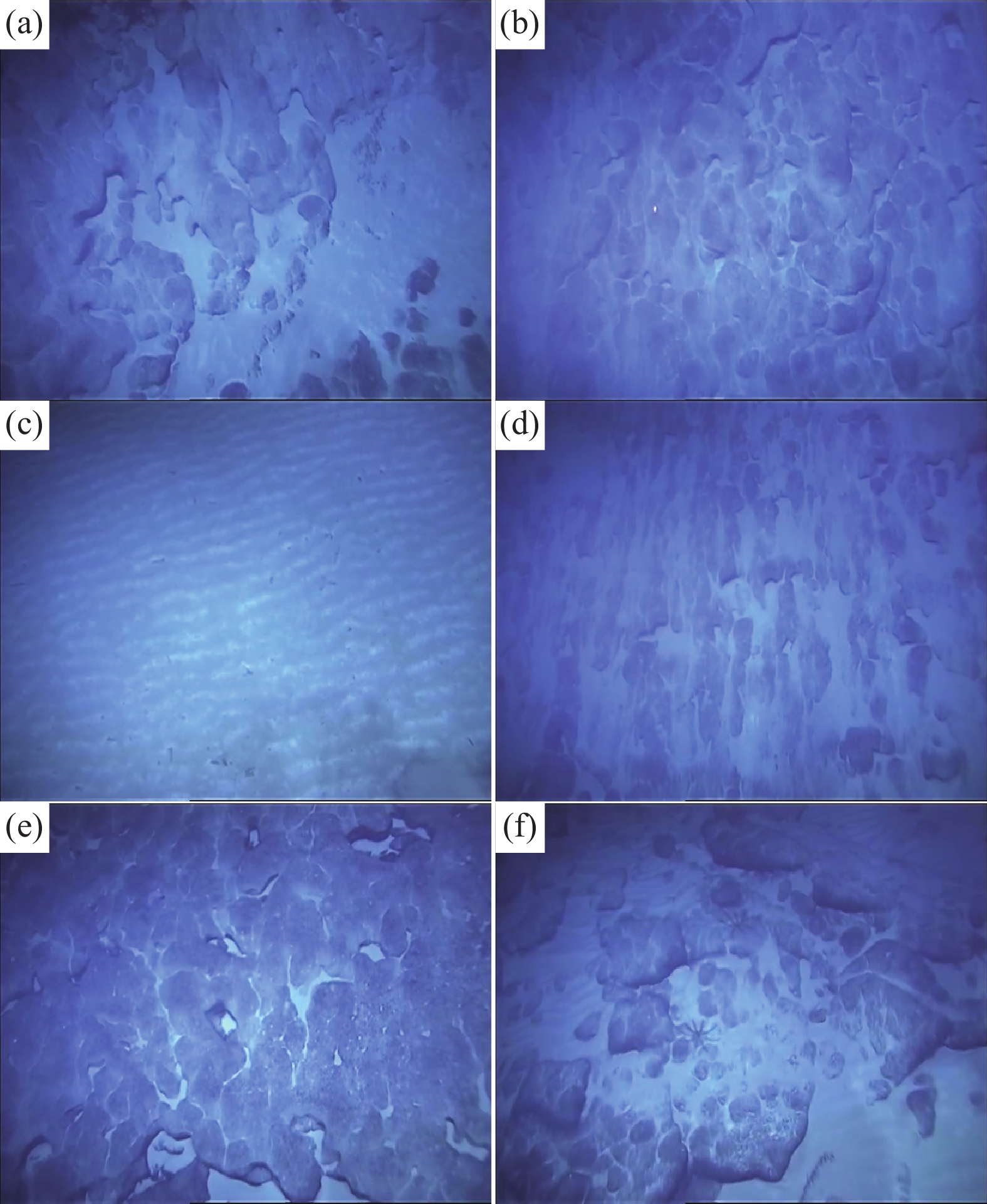
Typical screenshots for the dive 105. a–section A–B, FC with thin sediment covering; b–section B–C, FC with scour marks; c–section C–D, wavy sediment; d–section D–E, FC with thin sediment covering and scour marks; e–section E–F, FC; f–section F–G, FC with poor continuity and thin sediment layer, and development of gravel-like FC.
-
Figure 5.
Substrate distribution characteristics along the track of dive 106. a–FC and sediment distributions: Red indicates FCs (C1); pink indicates FCs with thin sediment covering (C2); black indicates sediment (S); b–depth and slope gradient profiles.
-
Figure 6.
Typical screenshots for dive 106. a–section A–B, FC with thin sediment layer and visible scour marks; b–section C–D, continuous distribution of FC, visible scour marks; c–section H–I, continuous distribution of FC; d–section I–J, poor continuity of FC, thin layer of sediment, and gravel-like FC.
-
Figure 7.
Substrate and backscatter intensity characteristics along the track of dive 105. a–substrate distribution: Red, C1; pink, C2; and black, S. b–acoustic backscatter intensity profile.
-
Figure 8.
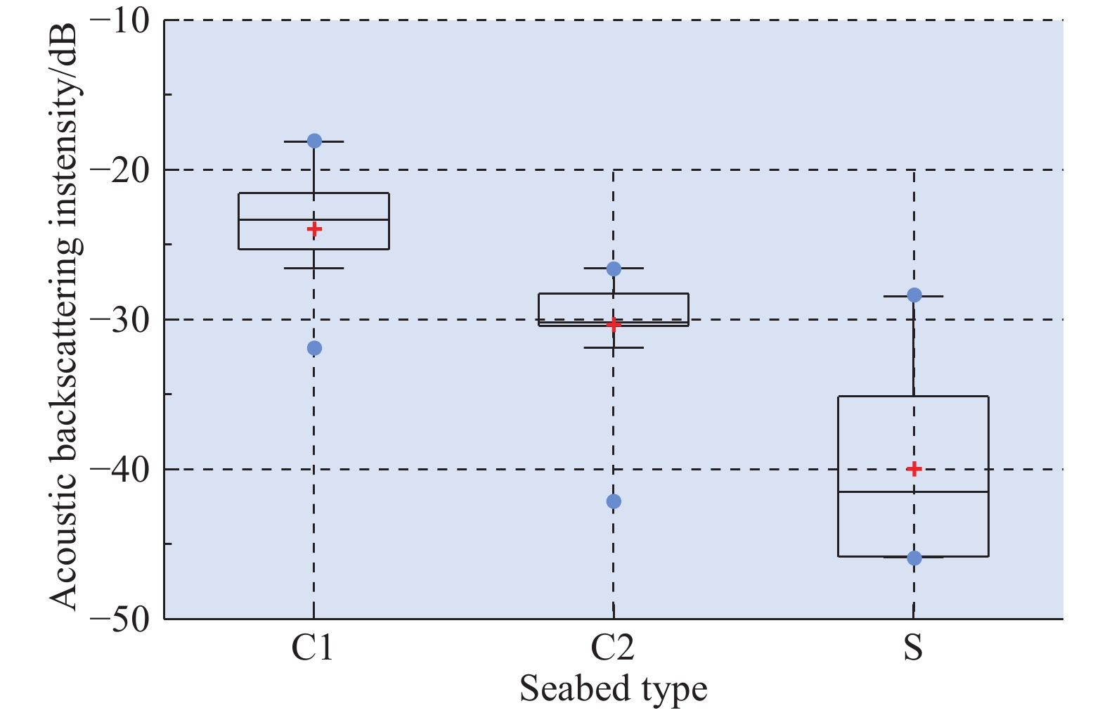
Box-whisker diagrams showing the relative backscatter intensity for each seabed type along the track for dive 105. Brackets represent the standard range of data = 1.5 × inter-quartile range; red crosses represent the means; solid blue circles represent the maximum and minimum values.
-
Figure 9.
Substrate and backscatter intensity characteristics along the track of dive 106. a–substrate distribution: Red, C1; pink, C2; black, S. b–acoustic backscatter intensity profile.
-
Figure 10.
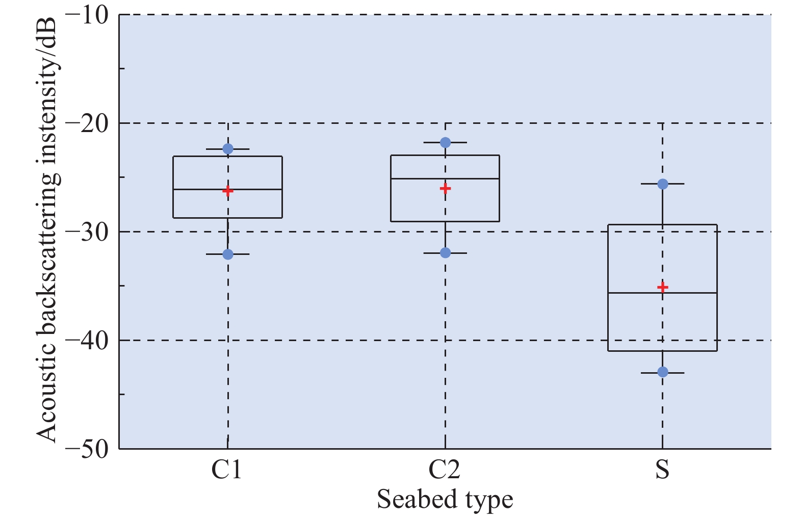
Box-whisker diagrams of relative backscatter intensity for each seabed type along the track of dive 106. Brackets represent the standard range of data = 1.5 × inter-quartile range; red crosses represent means; blue solid circles represent maximum and minimum values.
-
Figure 11.
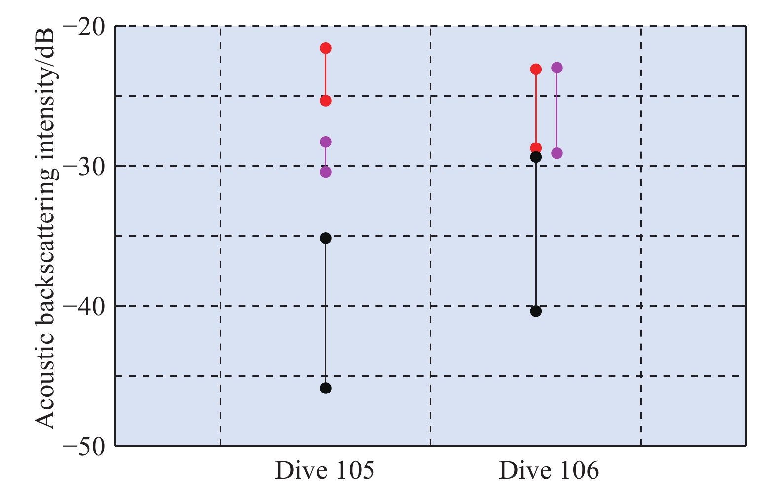
ABI inter-quartile ranges for each seabed type along the track of Dive 105 and Dive 106. Substrate distribution: red, C1; pink, C2; and black, S



 DownLoad:


