| Citation: | ZHANG Jian-kang, DONG Hua, CHENG Yan-pei, YUE Chen, LIU Kun. 2020. Compilation of hydrogeological map of China. Journal of Groundwater Science and Engineering, 8(4): 381-395. doi: 10.19637/j.cnki.2305-7068.2020.04.008 |
Compilation of hydrogeological map of China
-
Abstract
Hydrogeological map is one of the important carriers of groundwater related information. It directly reflects the hydrogeological conditions and previous investigation and research results of a mapping area. The hydrogeological map of China is a map reflecting the characteristics of hydrogeology and groundwater dynamics on a national scale. On the basis of the hydrogeological map of China (1: 4 000 000) compiled in 1988, this map compilation attempted to update and enhance the existing map, with the latest survey results from the project of National Investigation and Evaluation of Groundwater Resources and Environmental Problems led by China Geological Survey. Task of the mapping program included redefining groundwater types, quantifying the classification standard of the groundwater and adding the pore-fissure water in laterite layer of hilly basin. The multilayer structures for porous, karst and porous-fractured groundwater and their water-rich grades are reflected on the map. Based on the comprehensive summary of the latest hydrogeological data of China, this research conducts an in-depth analysis of the regional distribution characteristics of groundwater in China, utilizes a digital mapping process and establishes a cartographic database for the purpose of further use. With the enrichment of the content and the continuous improvement of cognitive level, mapping content can be updated quickly, which has practical significance for the concept of surveying and mapping and scientific popularization.
-

-
References
AN Le-sheng, ZHAO Quan-sheng, YE Si-yuan, et al. 2012. Hydrochemical characteristics and formation mechanism of shallow groundwater in the yellow river delta. Environmental Science, 33(2):370-378. Doi:0250-3301(2012)02-0370-09. CHEN Meng-xiong. 2007. A collection of papers on researches of groundwater in China. Beijing: China Land Press: 4. CHEN Meng-xiong, MA Feng-shan. 2002. Groundwater resources and environment of China. Beijing: Geological Publishing House, 24-32. CHENG Qiang, KOU Xiao-bing, HUANG Shao-bin, et al. 2004. The distributes and geologic environment characteristics of red beds in China. Journal of Engineering Geology, 12(1): 34-40. Doi:1004-9665/2004/12(01)-0034-07. CHEN Qian, MAO Yu, LI Cheng. 2013. Hydroc-hemistry characteristics of shallow ground-water in redbed of Luzhou, Sichuan. China Measurement & Testing, 39(6): 42-45. Doi:10.11857/j.issn.1674-5124.2013.06.012. CHENG Xu-xue, CHEN Chong-xi, YAN Cheng-yun, et al. 2008. Investigation and assessment of groundwater resources rational exploitation and utilization in Shule River Basin of Hexi Corridor. Beijing: Geological Publishing House: 27-31. CHEN Shu-hua, LIN Ci-luan, XU Wei-guang, et al. 2020. Age and Tectonic significance of volcanic rocks in cretaceous red beds in Fujian. Earth Science, 45(7): 2508-2523. Doi:1000-2383(2020)07-2508-16. FENG Wen-kai, FANG Hong-yu, LI Yi-he, et al. 2020. Hydrochemical characteristics and water quality evaluation of shallow groundwater in red-layer area. Water Power, 46(2):12-16, 84. Doi:10.3969/j.issn.0559-9342.2020.02.003. GUO Yong-chun, XIE Qiang, WEN Jiang-quan. 2007. Red beds distribution and engineering geological problem in China, Hydrogeology & Engineering Geology, 34(6):67-71. Doi:10.3969/j.issn.1000-3665.2007.06.016. HAN Ying, YAN Shi-long, MA Han-tian, et al. 2008. Investigation and assessment of groundwater resources and their environ-mental problems in Six basins of Shanxi Province. Beijing: Geological Publishing House: 71-77. HOU Guang-cai, ZHANG Mao-sheng. 2004. Groundwater resources and their sustainable utilization in the Ordos basin. Xi'an: Shaanxi Science and Technology Press: 129-139. JIAO Shu-qing, DAI Xi-sheng, 1988. Explanation of the hydrogeologic map of China. Beijing: China Cartographic Publishing House: 5-16. LI Guo-fen, WEI Fu-cai, et al. 1992. Explanation of the karst hydrogeologic map of China. Beijing: China Cartographic Publishing House: 10-13. LI Zhi, YU Meng-wen, ZHANG Li-ling, et al. 2009. Investigation and assessment of ground-water resources and their environmental issues in the west Liaohe Plain. Beijing: Geological Publishing House: 66-81. LIU Bin, MEN Guo-fa, WANG Zhan-he, et al. 2008. Groundwater exploration in the Tarim Basin. Beijing: Geological Publishing House: 16-18. LI Rui-min, YIN Zhi-qiang, WANG Yi, et al. 2018. Geological resources and environmental carrying capacity evaluation review, theory, and practice in China, China Geology, 1: 556-565. doi:10.31035/cg2018050 SHEN Tian-de, CHEN Xu-guang, WANG Wen-ke, et al. 2009. Investigation and assessment of groundwater resources and its environmental issues in the Junggar basin. Beijing: Geological Publishing House: 48-60. WANG Yong-gui, GUO Hong-ye, LI Jian, et al. 2008. Investigation and assessment of groundwater resources and their environ-mental issues in the Qaidam basin. Beijing: Geological Publishing House: 117-131. WEN Dong-guang, LIN Liang-jun, SUN Ji-chao, et al. 2012. Groundwater quality and contamination assessment in the main plains of Eastern China. Earth Science-Journal of China University of Geosciences. 37(2):220-228. Doi:10.3799/dqkx.2012.022. WU Xue-hua, QIAN Hui, YU Dong-mei, et al. 2009. Inveatigation and assessment of rational allocation of groundwater resources in the Yinchuan Plain. Beijing: Geological Publishing House: 29-36. YANG Xiang-kui, YANG Wen, ZHANG Feng-long, et al. 2008. Investigation and assessment of groundwater resources potential and ecoenvironment geology in Sanjiang Plain. Beijing: Geological Publishing House: 30-36. ZHANG Zong-hu, SUN Ji-chao, JING Ji-hong, et al. 2006. Groundwater resources map of China (1:4 000 000). Beijing: China Cartographic Publishing House. ZHANG Fa-wang, CHENG Yan-pei, DONG Hua, et al. 2012. Groundwater serial maps of Asia (1:8 000 000). Beijing: China Cartographic Publishing House. ZHANG Zong-hu, LI Lie-rong, CHEN De-hua, et al. 2004. Groundwater resources of China. Beijing: Sinomap Press: 32-39. ZHANG Zhao-ji, FEI Yu-hong, CHEN Zong-yu, et al. 2009. Investigation and assessment of sustainable utilization of groundwater resources in the North China Plain. Beijing: Geological Publishing House: 30-43. ZHANG Zong-hu, LI Lie-rong, CHEN De-hua, et al. 2004. The atlas of groundwater resources and environment of China. Beijing: Sinomap Press. ZHAO Hai-qing, ZHAO Yong-sheng, YANG Xiang-kui, et al. 2009. Investigation and assessment of groundwater resources and their related environmental problems in the Songnen Plain. Beijing: Geological Publishing House: 24-27. -
Access History

-
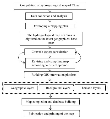
Figure 1.
Map of technical route
-
Figure 2.
Cartographic standard for groundwater type and water-bearing degree
-
Figure 3.
Cartographic method of underlying water-bearing formations with water supply significance and associated groundwater yield levels


 DownLoad:

