
| Qingdao Institute of marine geology, China Geological Survey | Host |
| Citation: |
HUANG Cheng, WU Nengyou, LONG Junqiao, TANG Wei, XIN Zhuo, LUO Shenglong, HU Xuan, YAN Li, XING Jingfeng, CHEN Long, ZHANG Yunzhong, GUO Zejun, LI Yang. Comprehensive geological survey and research on Wuzhizhou Island of Sanya City based on UAV tilt photography technology[J]. Marine Geology & Quaternary Geology, 2023, 43(3): 195-208. doi: 10.16562/j.cnki.0256-1492.2022092801

|
Comprehensive geological survey and research on Wuzhizhou Island of Sanya City based on UAV tilt photography technology
-
Abstract
It is extremely difficult to carry out comprehensive geological surveys on uninhabited island due to factors such as inconvenient transportation, lush vegetation coverage, and steep terrain. To overcome the shortage in in-situ investigational staff, reduce safety risks, and improve the working efficiency, the UAV (manned aerial vehicle) tilt photography technology was applied and tested in the Wuzhizhou Island, Hainan Province. A FEIMA D20 UAV carries a D-OP3000 module that equipped with 5 lens with which low-altitude (190m), multi-angle, and high-precision image data could be obtained quickly. The average ground resolution of the image was finer than 0.03m. In addition, Smart3D software was used to generate digital orthophoto maps (DOM) and to build a real-scene 3D model of the island. Therefore, the island could be observed in an omnidirectional way, and the overall understanding of the island was enhanced. Combined with a comprehensive study of digital orthophoto maps, the real-scene 3D model and field investigation, and the linear fracture characteristics of Wuzhizhou Island were obtained, and its origination was explored. The information of current status of land development and utilization of the island was extracted and 15 hidden risk points of geological disasters were spotted, including costal bluff collapse, fault activity, and beach erosion, to which countermeasures were proposed. This study provided a scientific basis for island development and utilization, ecological protection and restoration, geological disaster management, and comprehensive management of the islands alike.
-

-
References
[1] 龚旭峥, 高亚萍, 杨小央. 倾斜摄影实景三维技术在海岛调查中的应用[J]. 测绘技术装备, 2020, 22(4):69-70 doi: 10.3969/j.issn.1674-4950.2020.04.020 GONG Xuzheng, GAO Yaping, YANG Xiaoyang. Application of real 3D scene from tilt photogrammetry in island survey [J]. Geomatics Technology and Equipment, 2020, 22(4): 69-70. doi: 10.3969/j.issn.1674-4950.2020.04.020 [2] 卢汉明, 胡东平, 刘继东. 卫星遥感影像在海岛(礁)测图中的应用研究[J]. 海洋测绘, 2015, 35(1):70-72,75 doi: 10.3969/j.issn.1671-3044.2015.01.019 LU Hanming, HU Dongping, LIU Jidong. Application of satellite remote sensing imagery in island/reefs mapping [J]. Hydrographic Surveying and Charting, 2015, 35(1): 70-72,75. doi: 10.3969/j.issn.1671-3044.2015.01.019 [3] 李亚萍. 高分辨率遥感影像海岛礁地表覆盖变化检测与分析[D]. 兰州交通大学硕士学位论文, 2015: 1-78 LI Yaping. Change detection and analysis of surface coverage on Island and reefs via high resolution remote sensing image[D]. Master Dissertation of Lanzhou Jiaotong University, 2015: 1-78. [4] 李晓敏, 马毅, 张杰, 等. 基于高分遥感的西沙群岛典型海岛时空变化分析[J]. 海洋通报, 2020, 39(6):717-729 LI Xiaomin, MA Yi, ZHANG Jie, et al. Spatial and temporal dynamics of typical islands in the Xisha Islands using high-resolution satellite images [J]. Marine Science Bulletin, 2020, 39(6): 717-729. [5] 刘志军. 无居民海岛及其人类活动特征遥感识别方法研究[D]. 武汉大学博士学位论文, 2010: 1-42 LIU Zhijun. The study to the unhabitted islands and its human activity characteristics based on remote sensing[D]. Doctor Dissertation of Wuhan University, 2010: 1-42. [6] 马毅, 张杰, 李晓敏, 等. 遥感技术应用于海岛保护与利用规划的可行性研究[J]. 海洋开发与管理, 2009, 26(7):92-95 doi: 10.3969/j.issn.1005-9857.2009.07.019 MA Yi, ZHANG Jie, LI Xiaomin, et al. On the feasibility of the application of remote sensing technology to island conservation and usage planning [J]. Ocean Development and Management, 2009, 26(7): 92-95. doi: 10.3969/j.issn.1005-9857.2009.07.019 [7] 许祝华, 张彦彦, 杨晖, 等. 海域无人机遥感监测三维立体监管系统的建设与研究[J]. 海洋开发与管理, 2013, 30(6):16-18 doi: 10.3969/j.issn.1005-9857.2013.06.004 XU Zhuhua, ZHANG Yanyan, YANG Hui, et al. Construction and research of three-dimensional monitoring system for remote sensing monitoring of marine drones [J]. Ocean Development and Management, 2013, 30(6): 16-18. doi: 10.3969/j.issn.1005-9857.2013.06.004 [8] 杨国东, 王民水. 倾斜摄影测量技术应用及展望[J]. 测绘与空间地理信息, 2016, 39(1):13-15,18 doi: 10.3969/j.issn.1672-5867.2016.01.004 YANG Guodong, WANG Minshui. The tilt photographic measuration technique and expectation [J]. Geomatics & Spatial Information Technology, 2016, 39(1): 13-15,18. doi: 10.3969/j.issn.1672-5867.2016.01.004 [9] 金伟, 葛宏立, 杜华强, 等. 无人机遥感发展与应用概况[J]. 遥感信息, 2009(1):88-92 doi: 10.3969/j.issn.1000-3177.2009.01.017 JIN Wei, GE Hongli, DU Huaqiang, et al. A review on unmanned aerial vehicle remote sensing and its application [J]. Remote Sensing Information, 2009(1): 88-92. doi: 10.3969/j.issn.1000-3177.2009.01.017 [10] 刘倩, 梁志海, 范慧芳. 浅谈无人机遥感的发展及其行业应用[J]. 测绘与空间地理信息, 2016, 39(6):167-169 doi: 10.3969/j.issn.1672-5867.2016.06.053 LIU Qian, LIANG Zhihai, FAN Huifang. The development of UAV remote sensing and its application in Geo-information related industries [J]. Geomatics & Spatial Information Technology, 2016, 39(6): 167-169. doi: 10.3969/j.issn.1672-5867.2016.06.053 [11] 杨燕明, 郑凌虹, 文洪涛, 等. 无人机遥感技术在海岛管理中的应用研究[J]. 海洋开发与管理, 2011, 28(1):6-10 doi: 10.3969/j.issn.1005-9857.2011.01.002 YANG Yanming, ZHENG Linghong, WEN Hongtao, et al. Application of UAV remote sensing technology in island management [J]. Ocean Development and Management, 2011, 28(1): 6-10. doi: 10.3969/j.issn.1005-9857.2011.01.002 [12] 方德涛, 刘珊珊, 张笑. 低空无人机遥感系统在海岛潮间带监测中的应用[J]. 北京测绘, 2019, 33(1):71-75 doi: 10.19580/j.cnki.1007-3000.2019.01.016 FANG Detao, LIU Shanshan, ZHANG Xiao. Application of low altitude UAV remote sensing in intertidal zone monitoring of islands [J]. Beijing Surveying and Mapping, 2019, 33(1): 71-75. doi: 10.19580/j.cnki.1007-3000.2019.01.016 [13] 邓才龙, 刘焱雄, 田梓文, 等. 无人机遥感在海岛海岸带监测中的应用研究[J]. 海岸工程, 2014, 33(4):41-48 doi: 10.3969/j.issn.1002-3682.2014.04.005 DENG Cailong, LIU Yanxiong, TIAN Ziwen, et al. Application of UAV remote sensing in the monitoring of islands and coastal zones [J]. Coastal Engineering, 2014, 33(4): 41-48. doi: 10.3969/j.issn.1002-3682.2014.04.005 [14] 黄学富, 张宏胜, 孙福成. 三亚蜈支洲岛景区开发现状及发展对策分析[J]. 经济研究导刊, 2021(2):41-44 doi: 10.3969/j.issn.1673-291X.2021.02.012 HUANG Xuefu, ZHANG Hongsheng, SUN Fucheng. Analysis on the current situation and countermeasures of the development of Wuzhizhou Island scenic spot in Sanya [J]. Economic Research Guide, 2021(2): 41-44. doi: 10.3969/j.issn.1673-291X.2021.02.012 [15] 张晓浩, 黄华梅, 吴秋生, 等. 三亚市蜈支洲岛海岸侵蚀与沉积的定量分析[J]. 热带海洋学报, 2015, 34(5):51-56 doi: 10.11978/2014125 ZHANG Xiaohao, HUANG Huamei, WU Qiusheng, et al. Quantitative analysis of coastal erosion and deposition on Wuzhizhou Island of Sanya City [J]. Journal of Tropical Oceanography, 2015, 34(5): 51-56. doi: 10.11978/2014125 [16] 匡巧娟. 海南蜈支洲岛景观资源的保护与利用研究[D]. 海南大学硕士学位论文, 2018: 1-79 KUANG Qiaojuan. The study of protection and utilization on landscape resources in Hainan Wuzhizhou Island[D]. Master Dissertation of Hainan University, 2018: 1-79. [17] 马文刚, 夏景全, 魏一凡, 等. 三亚蜈支洲岛海洋牧场近岛区底表大型底栖动物群落结构及评价[J]. 热带海洋学报, 2022, 41(3):135-146 doi: 10.11978/2021125 MA Wen’gang, XIA Jingquan, WEI Yifan, et al. Community structure evaluation of epifaunal macrozoobenthos in the near-island waters of marine ranching in Wuzhizhou Island, Sanya [J]. Journal of Tropical Oceanography, 2022, 41(3): 135-146. doi: 10.11978/2021125 [18] Huang J Z, Wang F X, Zhao H W, et al. Reef benthic composition and coral communities at the Wuzhizhou Island in the south China sea: The impacts of anthropogenic disturbance [J]. Estuarine, Coastal and Shelf Science, 2020, 243: 106863. doi: 10.1016/j.ecss.2020.106863 [19] 国家市场监督管理总局, 国家标准化管理委员会. GB/T 39612-2020 低空数字航摄与数据处理规范[S]. 北京: 中国标准出版社, 2020 State Administration of Market Supervision and Administration of the People's Republic of China, Standardization Administration of the People's Republic of China. GB/T 39612-2020 Specifications for low-altitude digital aerial photography and data processing[S]. Beijing: Standards Press of China, 2020. [20] 范诗玥, 张峰, 卢文虎, 等. 基于红黑树数据结构的海岸线无人机正射影像拼接研究[J]. 海洋通报, 2016, 35(2):132-139 doi: 10.11840/j.issn.1001-6392.2016.02.002 FAN Shiyue, ZHANG Feng, LU Wenhu, et al. Study on the coastline orthophoto mosaic using UAV images based on red-black data structure [J]. Marine Science Bulletin, 2016, 35(2): 132-139. doi: 10.11840/j.issn.1001-6392.2016.02.002 [21] 闫烨琛, 高学飞, 于向吉, 等. 无人机倾斜摄影测量技术在地质灾害隐患调查中的应用研究[J]. 科技创新与应用, 2022, 12(17):193-196 YAN Yechen, GAO Xuefei, YU Xiangji, et al. Research on the application of UAV oblique photogrammetry technology in the investigation of geological hazards [J]. Technology Innovation and Application, 2022, 12(17): 193-196. [22] 张川, 赵志国, 赵向东, 等. POS辅助空三数据建立立体模型及精度检测[J]. 测绘与空间地理信息, 2018, 41(2):171-173 doi: 10.3969/j.issn.1672-5867.2018.02.048 ZHANG Chuan, ZHAO Zhiguo, ZHAO Xiangdong, et al. Three-dimensional model building and precision testing with data of POS supported aerial triangulation [J]. Geomatics & Spatial Information Technology, 2018, 41(2): 171-173. doi: 10.3969/j.issn.1672-5867.2018.02.048 [23] 郝思宝. 数字正射影像建库关键技术研究[D]. 南京师范大学硕士学位论文, 2007: 1-52 HAO Sibao. Research on the key technologies of building digital orthophoto map database[D]. Master Dissertation of Nanjing Normal University, 2007: 1-52. [24] 夏邦栋. 普通地质学[M]. 2版. 北京: 地质出版社, 1995 XIA Bangdong. Physical Geology[M]. 2nd ed. Beijing: Geological Press, 1995. [25] 董荣. 花岗岩球状风化的形成机理新析[J]. 矿产与地质, 2016, 30(5):842-845 doi: 10.3969/j.issn.1001-5663.2016.05.025 DONG Rong. A new analysis of the formation mechanism of granite spherical weathering process [J]. Mineral Resources and Geology, 2016, 30(5): 842-845. doi: 10.3969/j.issn.1001-5663.2016.05.025 [26] 中华人民共和国国家质量监督检验检疫总局, 中国国家标准化管理委员会. GB/T 21010-2017 土地利用现状分类[S]. 北京: 中国标准出版社, 2017 General Administration of Quality Supervision, Inspection and Quarantine of the People's Republic of China, Standardization Administration of the People's Republic of China. GB/T 21010-2017 Current land use classification[S]. Beijing: Standards Press of China, 2017. [27] 杜军, 李培英. 海岛地质灾害风险评价指标体系初建[J]. 海洋开发与管理, 2010, 27(S1):80-82 doi: 10.3969/j.issn.1005-9857.2010.z1.017 DU Jun, LI Peiying. On the building of risk assessment system for geological hazards of island [J]. Ocean Development and Management, 2010, 27(S1): 80-82. doi: 10.3969/j.issn.1005-9857.2010.z1.017 [28] 李拴虎, 刘乐军, 高伟. 福建东山岛地质灾害区划[J]. 海洋地质前沿, 2013, 29(8):45-52 doi: 10.16028/j.1009-2722.2013.08.010 LI Shuanhu, LIU Lejun, GAO Wei. Geo-Hazard classification in Dongshan Island of Fujian Province [J]. Marine Geology Frontiers, 2013, 29(8): 45-52. doi: 10.16028/j.1009-2722.2013.08.010 [29] 李萍, 刘杰, 徐元芹, 等. 我国典型海岛主要地质灾害类型及防治措施[J]. 海洋开发与管理, 2018, 35(5):60-64 doi: 10.3969/j.issn.1005-9857.2018.05.012 LI Ping, LIU Jie, XU Yuanqin, et al. Main geological disasters in typical Islands and preventive Measures in China [J]. Ocean Development and Management, 2018, 35(5): 60-64. doi: 10.3969/j.issn.1005-9857.2018.05.012 [30] 徐元芹, 刘乐军, 李培英, 等. 我国典型海岛地质灾害类型特征及成因分析[J]. 海洋学报, 2015, 37(9):71-83 XU Yuanqin, LIU Lejun, LI Peiying, et al. Geology disaster feature and genetic analysis of typical islands, China [J]. Haiyang Xuebao, 2015, 37(9): 71-83. [31] 孙丽. 厦门海岸侵蚀淤积灾害及防治研究[D]. 中国地质大学(北京)硕士学位论文, 2017 SUN Li. Study on disasters and prevention of erosion and sedimentation in Xiamen coast[D]. Master Dissertation of China University of Geosciences (Beijing), 2017. [32] 桂峰, 樊超. 海岛生态环境调查与评价[M]. 北京: 海洋出版社, 2018: 1-13 GUI Feng, FAN Chao. Ecological Environment Investigation and Evaluation of Islands[M]. Beijing: China Ocean Press, 2018: 1-13. [33] 谢财富, 丁式江, 傅太安, 等. 乐东县幅(E49C002001东北角)、陵水县幅(E49C002002西北角)1: 25万区域地质调查报告[R]. 宜昌: 宜昌地质矿产研究所, 2004 XIE Caifu, DING Shijiang, FU Taian, et al. 1: 250 000 Regional geological survey report of Ledong County mapheet (E49C002001, Northeast Corner) and Lingshui County mapsheet (E49C002002, Northwest Corner)[R]. Yichang: Yichang Institute of Geology and Mineral Resources, 2004. [34] 全国海岛资源综合调查报告编写组. 全国海岛资源综合调查报告[M]. 北京: 海洋出版社, 1996: 91-115 Compilation Group of the National Island Resources Comprehensive Survey Report. National Comprehensive Survey Report on Island Resources[M]. Beijing: China Ocean Press, 1996: 91-115. [35] 张业明, 谢才富, 付太安, 等. 海南岛地质构造演化刍论[J]. 科学技术与工程, 2005, 5(20):1485-1487 doi: 10.3969/j.issn.1671-1815.2005.20.005 ZHANG Yeming, XIE Caifu, FU Taian, et al. Tectonic evolution of Hainan Island [J]. Science Technology and Engineering, 2005, 5(20): 1485-1487. doi: 10.3969/j.issn.1671-1815.2005.20.005 [36] 唐立梅, 陈汉林, 董传万, 等. 中国东南部晚中生代构造伸展作用: 来自海南岛基性岩墙群的证据[J]. 岩石学报, 2010, 26(4):1204-1216 TANG Limei, CHEN Hanlin, DONG Chuanwan, et al. Late Mesozoic tectonic extension in SE China: evidence from the basic dike swarms in Hainan Island, China [J]. Acta Petrologica Sinica, 2010, 26(4): 1204-1216. [37] 徐栋, 杨敏, 苗宇宏, 等. 基于无人机高光谱遥感的海岛岸线精准提取方法研究与应用[J]. 海洋科学, 2020, 44(12):54-60 XU Dong, YANG Min, MIAO Yuhong, et al. Research and application of accurate extraction method of island shoreline based on hyperspectral remote sensing of unmanned aerial vehicle [J]. Marine Sciences, 2020, 44(12): 54-60. [38] 沈蔚, 王家为, 王林振, 等. 一种基岩海(岛)岸线自动提取新方法[J]. 上海海洋大学学报, 2015, 24(6):975-981 doi: 10.12024/jsou.20140901184 SHEN Wei, WANG Jiawei, WANG Linzhen, et al. One new method of bedrock (island) coastline extraction [J]. Journal of Shanghai Ocean University, 2015, 24(6): 975-981. doi: 10.12024/jsou.20140901184 [39] 常立侠, 冼嘉俊, 陈昌亮, 等. 海岛岸线界定标准及方法初探[J]. 海岸工程, 2015, 34(2):89-96 doi: 10.3969/j.issn.1002-3682.2015.02.011 CHANG Lixia, XIAN Jiajun, CHEN Changliang, et al. A preliminary study on the standard and method of Island coastline definition [J]. Coastal Engineering, 2015, 34(2): 89-96. doi: 10.3969/j.issn.1002-3682.2015.02.011 [40] 李刚, 万荣胜, 陈泓君, 等. 海南岛南部海岸线变迁及其成因[J]. 海洋地质前沿, 2018, 34(1):48-54 doi: 10.16028/j.1009-2722.2018.01008 LI Gang, WAN Rongsheng, CHEN Hongjun, et al. Coastline changes and their origin in the southern Hainan Island [J]. Marine Geology Frontiers, 2018, 34(1): 48-54. doi: 10.16028/j.1009-2722.2018.01008 -
Access History
Figures(18)
Tables(2)

Export File
Citation
HUANG Cheng, WU Nengyou, LONG Junqiao, TANG Wei, XIN Zhuo, LUO Shenglong, HU Xuan, YAN Li, XING Jingfeng, CHEN Long, ZHANG Yunzhong, GUO Zejun, LI Yang. Comprehensive geological survey and research on Wuzhizhou Island of Sanya City based on UAV tilt photography technology[J]. Marine Geology & Quaternary Geology, 2023, 43(3): 195-208. doi: 10.16562/j.cnki.0256-1492.2022092801
Format
Content
 DownLoad:


-
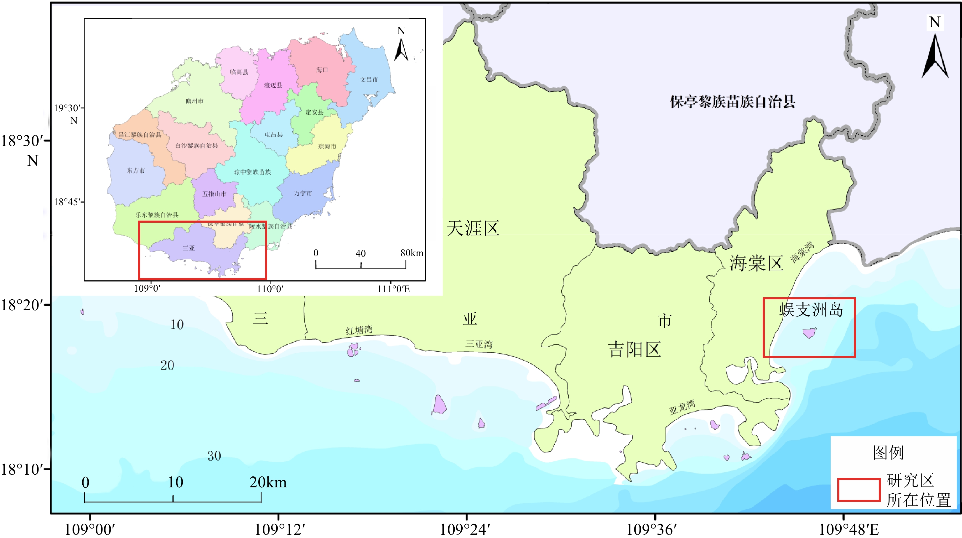
Figure 1.
Geographical location of the study area
-
Figure 2.
Route planning of the UAV tilt photographing
-
Figure 3.
3D real scene model of the Wuzhizhou Island
-
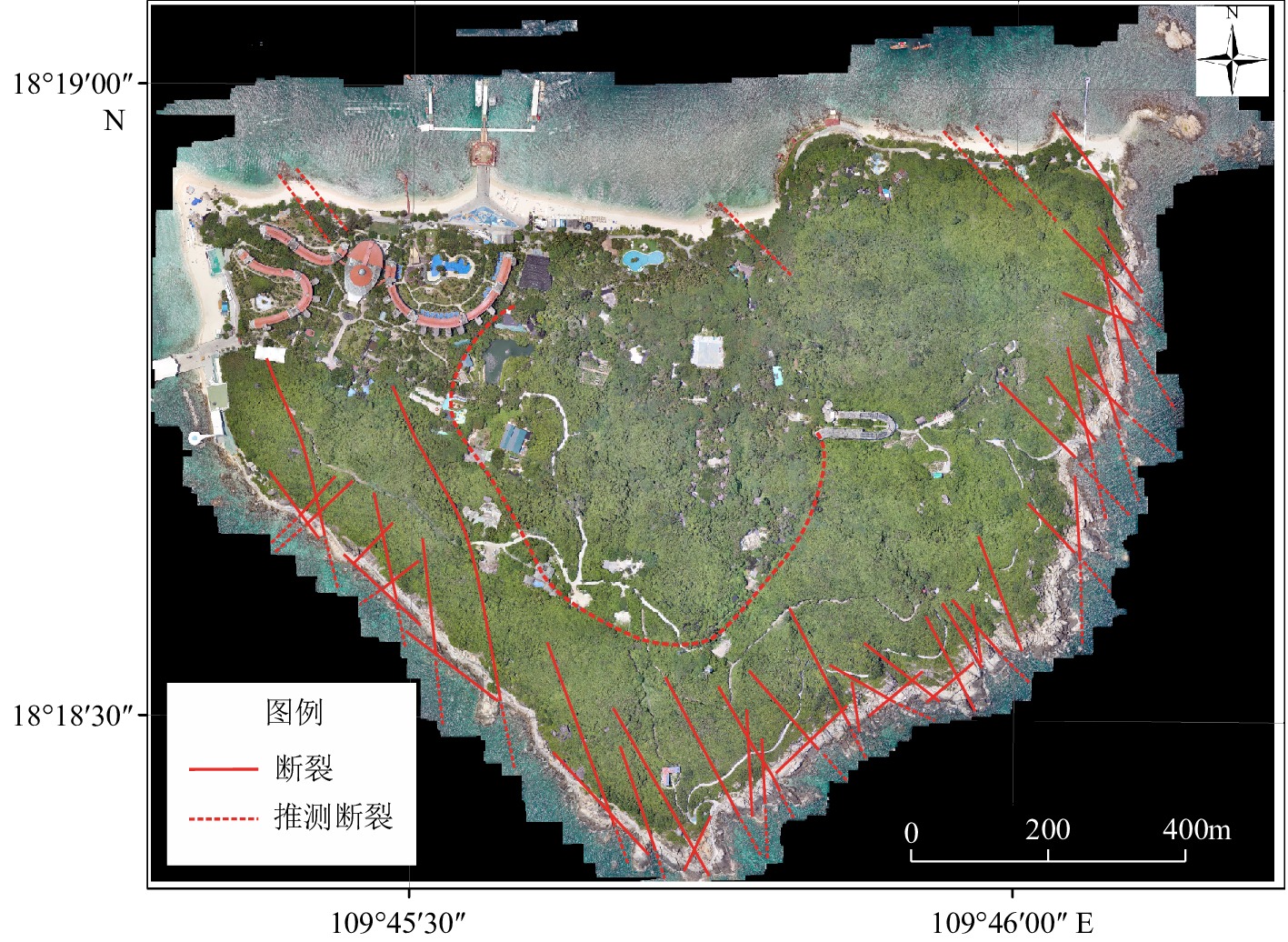
Figure 4.
Distribution of linear fracture in Wuzhizhou Island
-
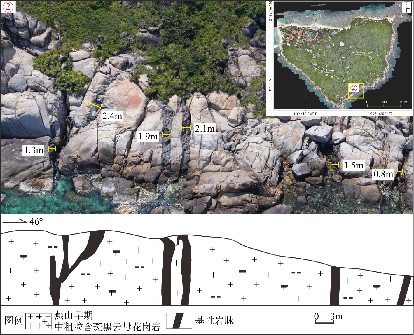
Figure 5.
Basic dykes developed in southeast of the Wuzhizhou Island
-
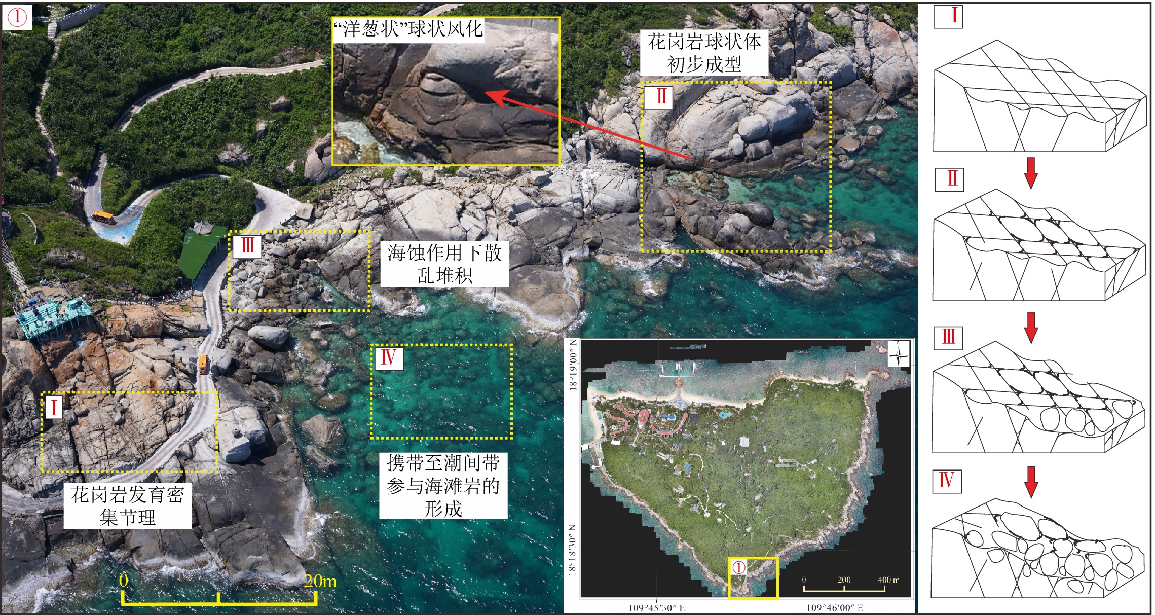
Figure 6.
Different development stages of spherical weathering alone the coastal Wuzhizhou Island
-
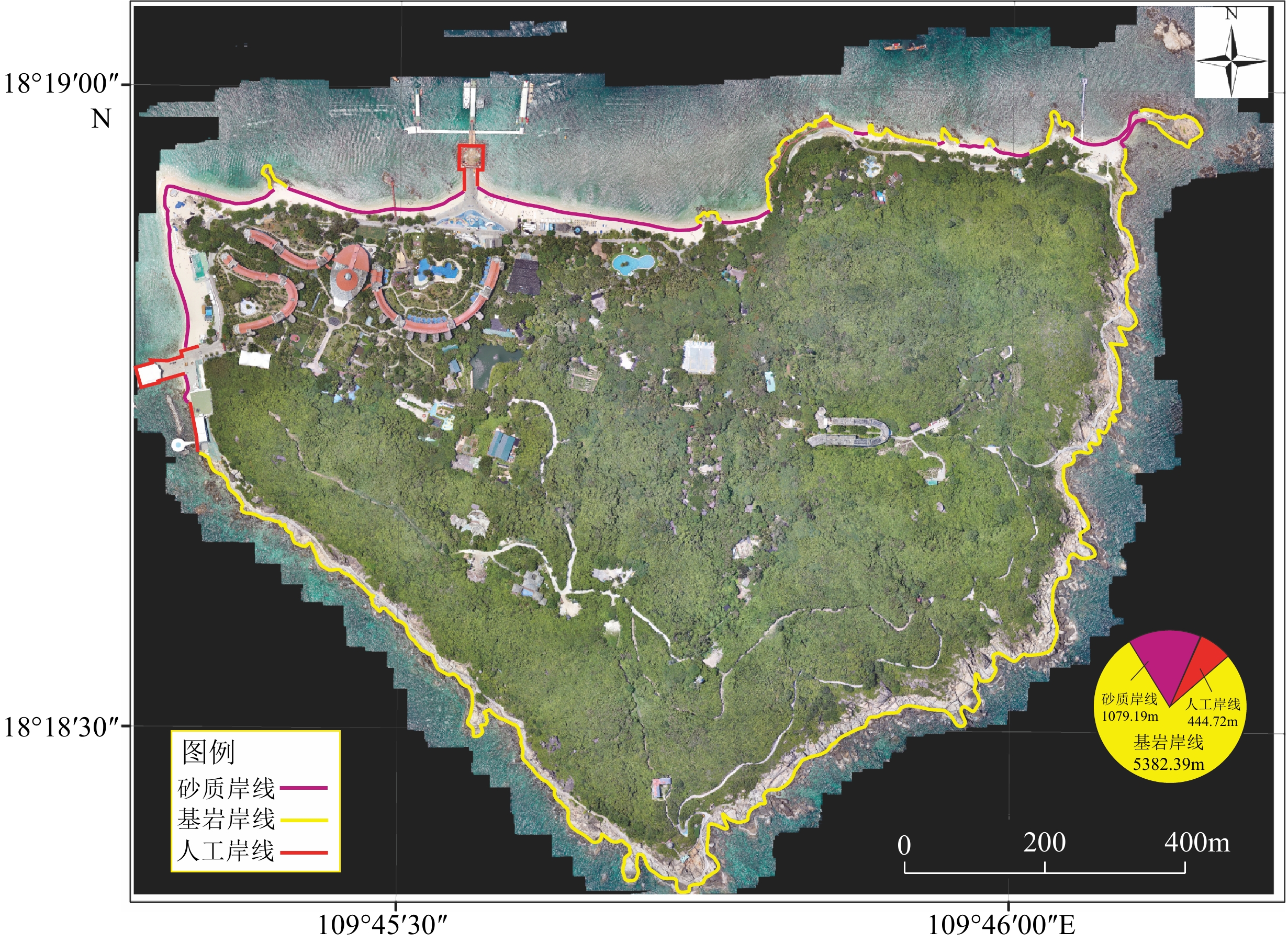
Figure 7.
Coastline types and spatial distribution of the Wuzhizhou Island
-
Figure 8.
Sandy beach of the northern Wuzhizhou Island
-
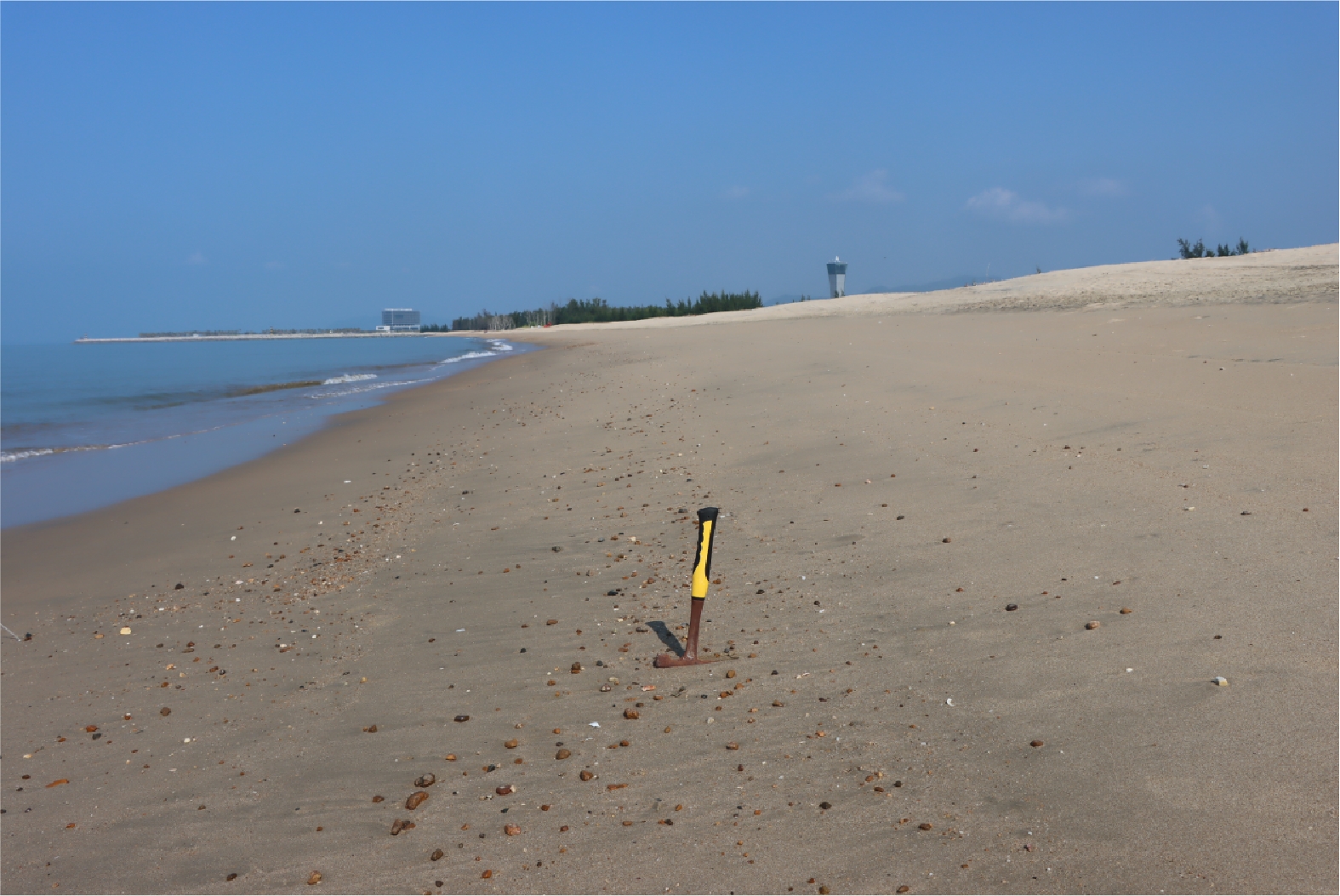
Figure 9.
Sandy beach with pebbles and cobbles in the Yazhou Bay
-
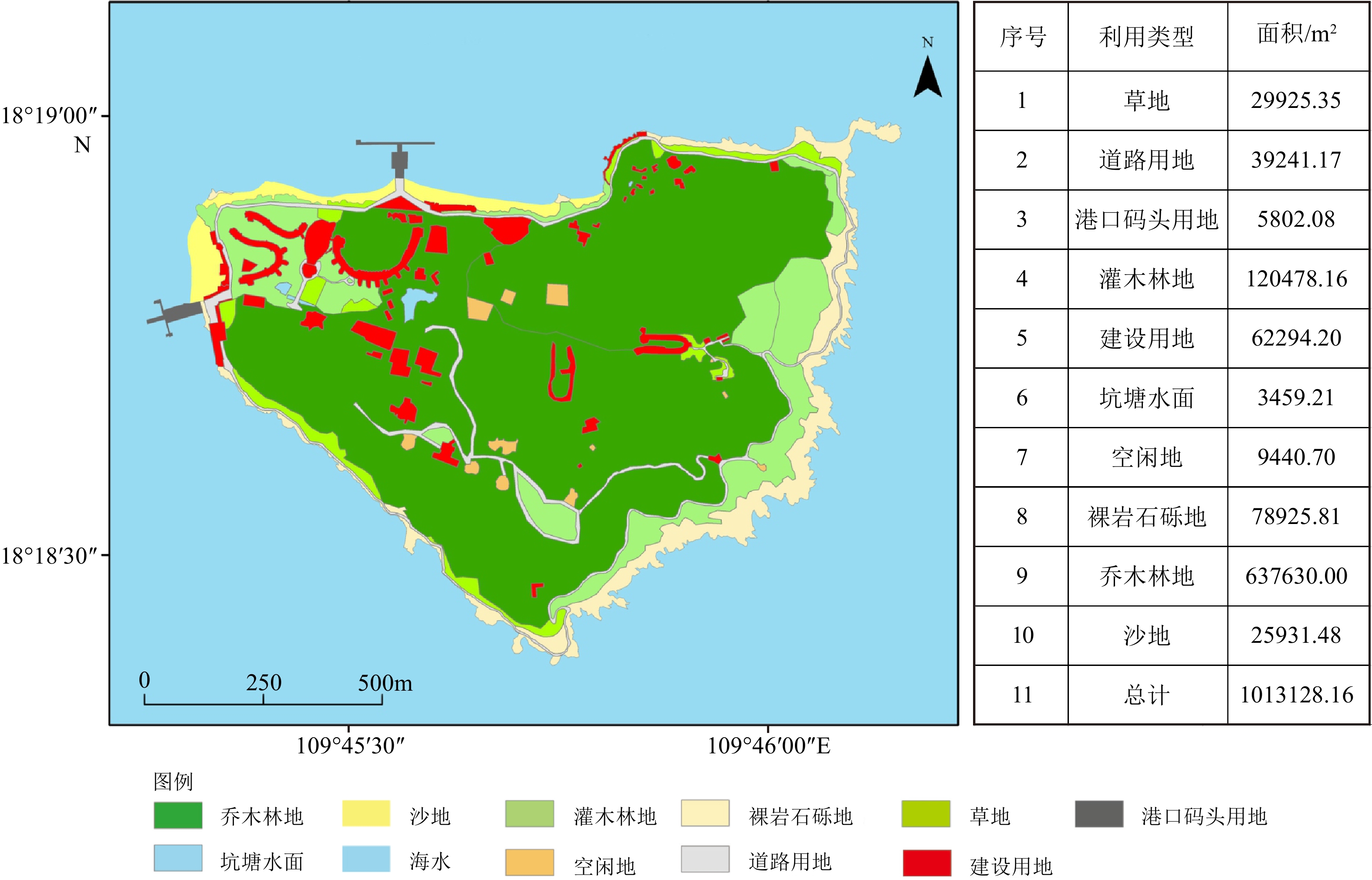
Figure 10.
Current situation of land development and utilization in the Wuzhizhou Island
-
Figure 11.
Distribution of geological hazards in the Wuzhizhou Island
-
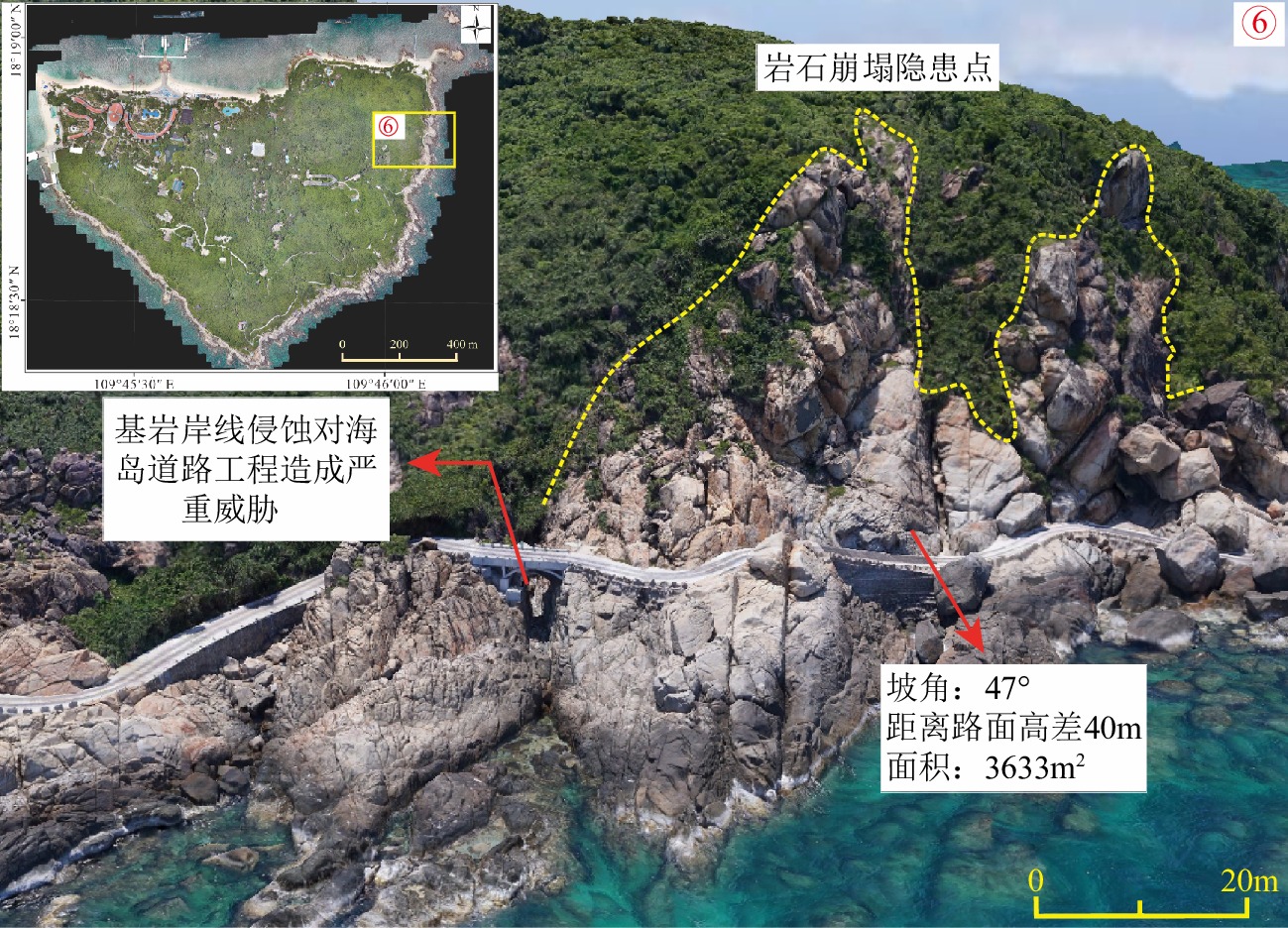
Figure 12.
A hidden risk point of bluff collapse on the eastern side of the Wuzhizhou Island
-
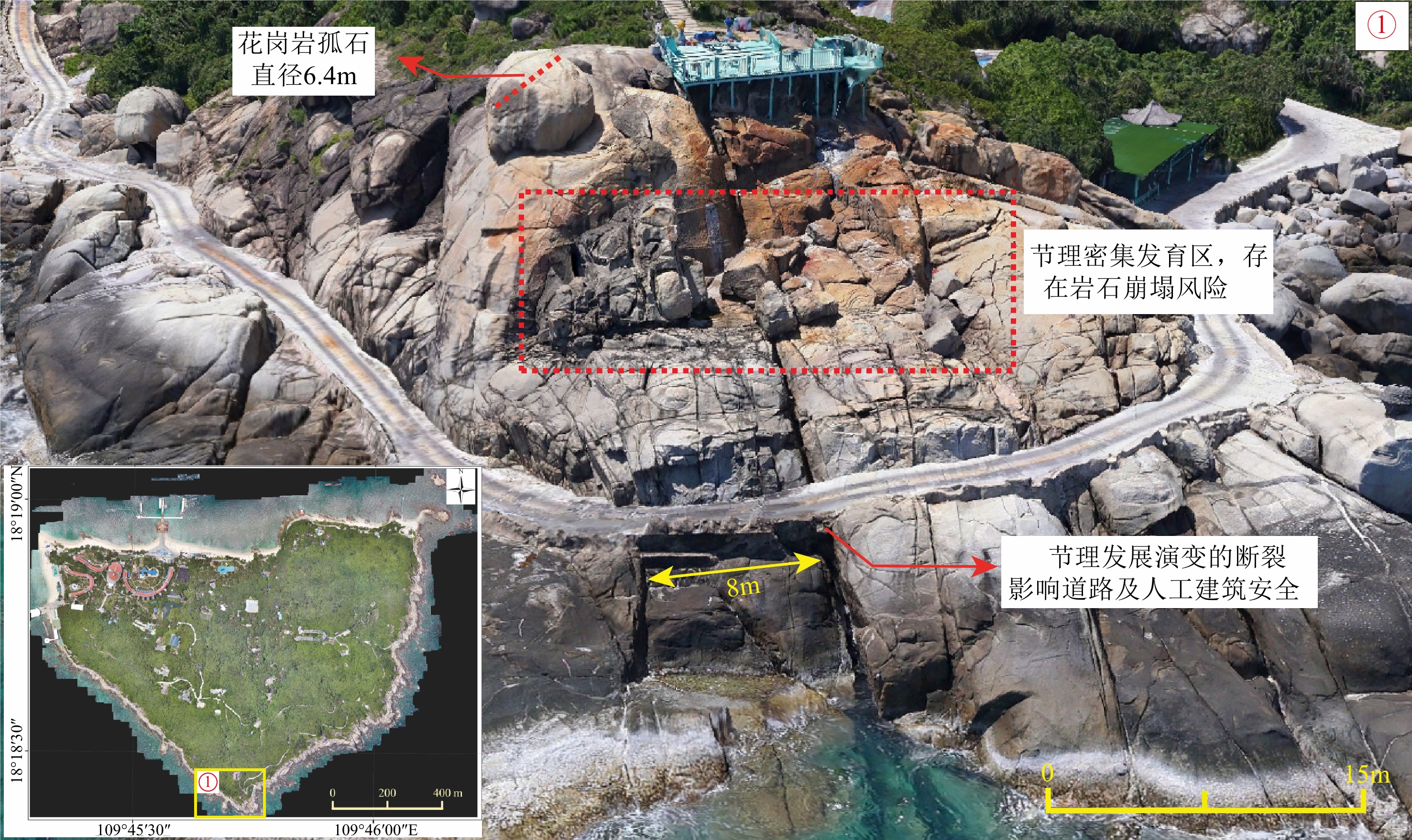
Figure 13.
A hidden risk point of bluff collapse in the southern Wuzhizhou Island
-
Figure 14.
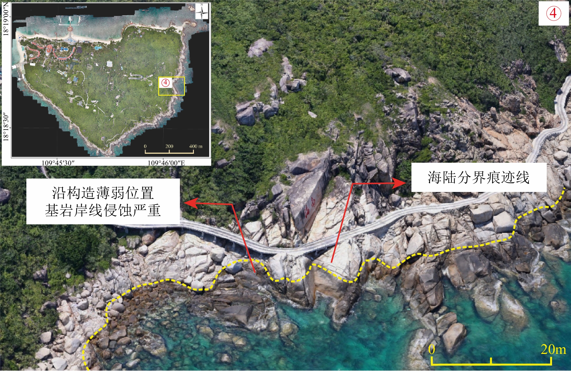
An erosion section of rocky beach on the eastern side of Wuzhizhou Island
-
Figure 15.
A siltation section of sandy coastline in the northern Wuzhizhou Island
-
Figure 16.
Sketch of a tensional fracture in near S-N direction in the southeastern side of Wuzhizhou Island
-
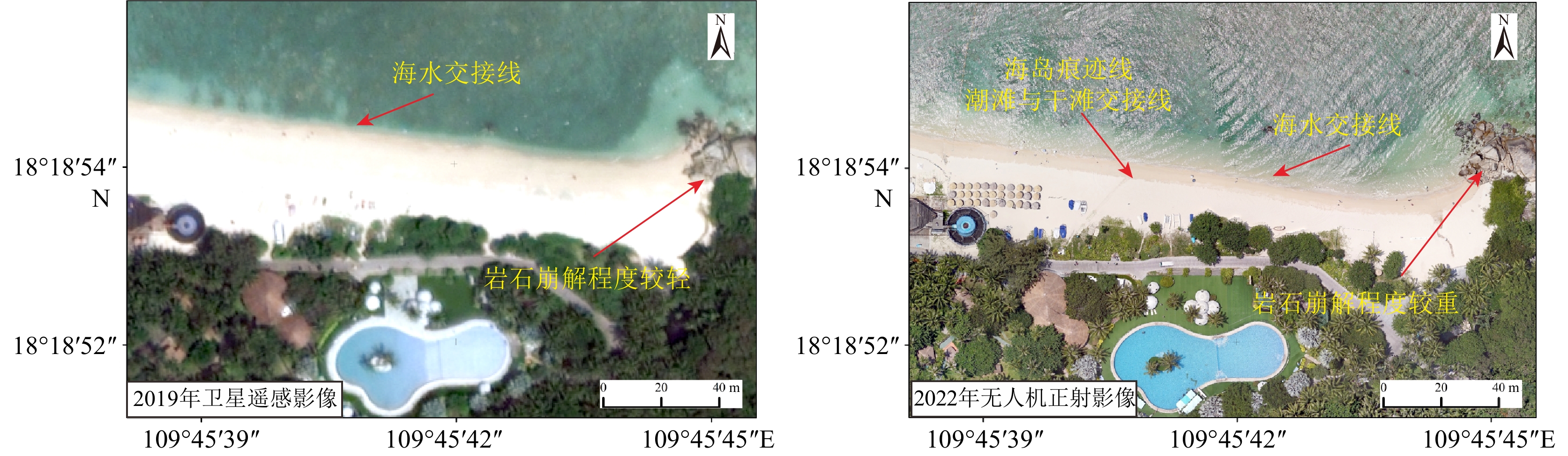
Figure 17.
Identification of island trace line in sandy coastline
-
Figure 18.
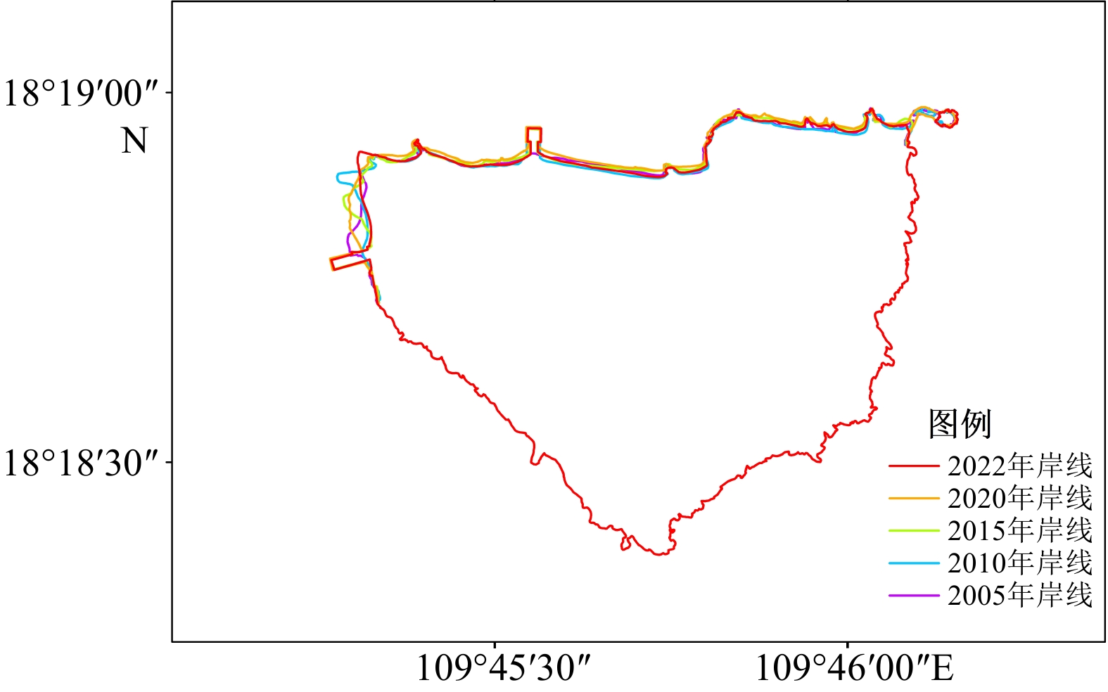
The coastline changes of the Wuzhizhou Island since 2005