
| China Geological Environment Monitoring Institute, China Geological Disaster Prevention Engineering Industry Association | Host |

| Citation: |
ZHANG Xiangyuan. Construction and implementation of an automatic algorithm for generating information of geological disaster floor risk warning products based on GIS and GDAL[J]. The Chinese Journal of Geological Hazard and Control, 2022, 33(5): 76-82. doi: 10.16031/j.cnki.issn.1003-8035.202205036

|
Construction and implementation of an automatic algorithm for generating information of geological disaster floor risk warning products based on GIS and GDAL
-
Abstract
Since 2003, mainland China has carried out regional geological disaster early warning work during the flood season and formed early warning products to be released to the public, which plays an important role in geological disaster prevention and control. The geological disaster warning description information is an important component of the geological disaster warning product, including the warning range, grade, time period, and text description. In order to quickly form authoritative, scientific, and accurate information, this paper studies a technical algorithm that can efficiently and automatically analyze and form preliminary early warning product description information and conducts verification analysis on the algorithm. The algorithm uses the administrative division map and early warning division map of the study area as data sources.Based on the designed three-level warning level as the main key of the set concept model of the warning level, Using GIS technology, through the use of spatial information superposition and discrimination, the calculation of the distribution area ratio of the warning level, the description of the distribution range of the warning level, and the calculation of the unit distribution orientation of the warning level as key methods, the information on the map can be quickly Converted to an intuitive text description, the automatic acquisition of early warning product description information can be realized.In the verification process, 11 virtual townships are designed as the warning range. The warning zoning layer takes 3×3KM as the warning level unit. The total number of warning units is 5194, and the file is in Shapefile format. The verification process is based on the GDAL library (Geospatial Data Abstraction Library)and the C++ language. A software tool is designed for the algorithm, and the experimental data is used for verification and analysis. The results show that the early warning description information formed by the algorithm is completely consistent with the spatial presentation results of the early warning zoning layer, and the calculation process is efficient and fast, which can significantly improve the precision of early warning. It is fully suitable for promotion and use in practical work.
-
Keywords:
- GIS /
- GDAL /
- geological hazard early warning products /
- automation
-

-
References
[1] 刘传正,刘艳辉,温铭生,等. 中国地质灾害气象预警实践:2003—2012[J]. 中国地质灾害与防治学报,2015,26(1):1 − 8. [LIU Chuanzheng,LIU Yanhui,WEN Mingsheng,et al. Early warning for regional geo-hazards during 2003-2012,China[J]. The Chinese Journal of Geological Hazard and Control,2015,26(1):1 − 8. (in Chinese with English abstract) [2] 中国地质灾害防治工程行业协会. 地质灾害区域气象风险预警标准(试行): T/CAGHP 039-2018[S]. 武汉: 中国地质大学出版社, 2018 China Geological Disaster Prevention Engineering Association. Regional meteorological risk early warning standard for geological disaster (trial): T/CAGHP 039-2018[S]. Wuhan: ChinaUniversity of Geosciences Press, 2018. (in Chinese) [3] 汪民. 关于地质灾害防治需要关注的几个问题[J]. 中国地质灾害与防治学报,2022,33(1):1 − 5. [WANG Min. Several problems needing attention in the prevention and control of geological disasters[J]. The Chinese Journal of Geological Hazard and Control,2022,33(1):1 − 5. (in Chinese) doi: 10.16031/j.cnki.issn.1003-8035.2022.01-01 [4] 唐军峰, 唐雪梅, 周基, 等. 滑坡堆积体变形失稳机制—以贵州剑河县东岭信滑坡为例[J]. 吉林大学学报(地球科学版),2022,52(2):503 − 516. [TANG Junfeng, TANG Xuemei, ZHOU Ji, et al. Deformation and instability mechanism of landslide accumulation:A case study of donglingxin landslide accumulation in Jianhe County, Guizhou Province[J]. Journal of Jilin University (Earth Science Edition),2022,52(2):503 − 516. (in Chinese with English abstract) [5] 金亚兵, 傅旭东. 滑坡泥石流灾害风险评价研究及其应用[M]. 北京: 地质出版社, 2018. JIN Yabing, FU Xudong. Landslide and debris flow disaster risk assessment research and applications[M]. Beijing: Geological Publishing House, 2018. (in Chinese) [6] 曹洪洋, 袁颖, 贾磊. 区域降雨型滑坡灾害预警预报[M]. 北京: 地质出版社, 2017 CAO Hongyang, YUAN Ying, JIA Lei. Early warning and forecast of regional rainfall landslide disaster[M]. Beijing: Geological Publishing House, 2017. (in Chinese) [7] 张以晨, 张继权, 张峰. 极端降雨诱发地质灾害风险评价、预警及管理对策研究以吉林省东南部山区为例[M]. 北京: 科学出版社, 2017 ZHANG Yichen, ZHANG Jiquan, ZHANG Feng. Study on risk assessment, early warning and management of geological disasters caused by extreme rainfall[M]. Beijing: Science Press, 2017. (in Chinese) [8] TAN Q L,HUANG Y,HU J,et al. Application of artificial neural network model based on GIS in geological hazard zoning[J]. Neural Computing and Applications,2021,33(2):591 − 602. doi: 10.1007/s00521-020-04987-4 [9] 王晓芳,侯恩科,张志华. 坐标方位角算法在GIS中的应用[J]. 测绘科学,2011,36(2):239 − 240. [WANG Xiaofang,HOU Enke,ZHANG Zhihua. Application of azimuth angle algorithm in GIS[J]. Science of Surveying and Mapping,2011,36(2):239 − 240. (in Chinese with English abstract) doi: 10.16251/j.cnki.1009-2307.2011.02.037 [10] 李民录. GDAL源码剖析与开发指南[M]. 北京: 人民邮电出版社, 2014 LI Minlu. GDAL source code analysis and development Guide[M]. Beijing: Posts & Telecom Press, 2014. (in Chinese) -
Access History
Figures(10)
Tables(3)

Export File
Citation
ZHANG Xiangyuan. Construction and implementation of an automatic algorithm for generating information of geological disaster floor risk warning products based on GIS and GDAL[J]. The Chinese Journal of Geological Hazard and Control, 2022, 33(5): 76-82. doi: 10.16031/j.cnki.issn.1003-8035.202205036
Format
Content
 DownLoad:


-
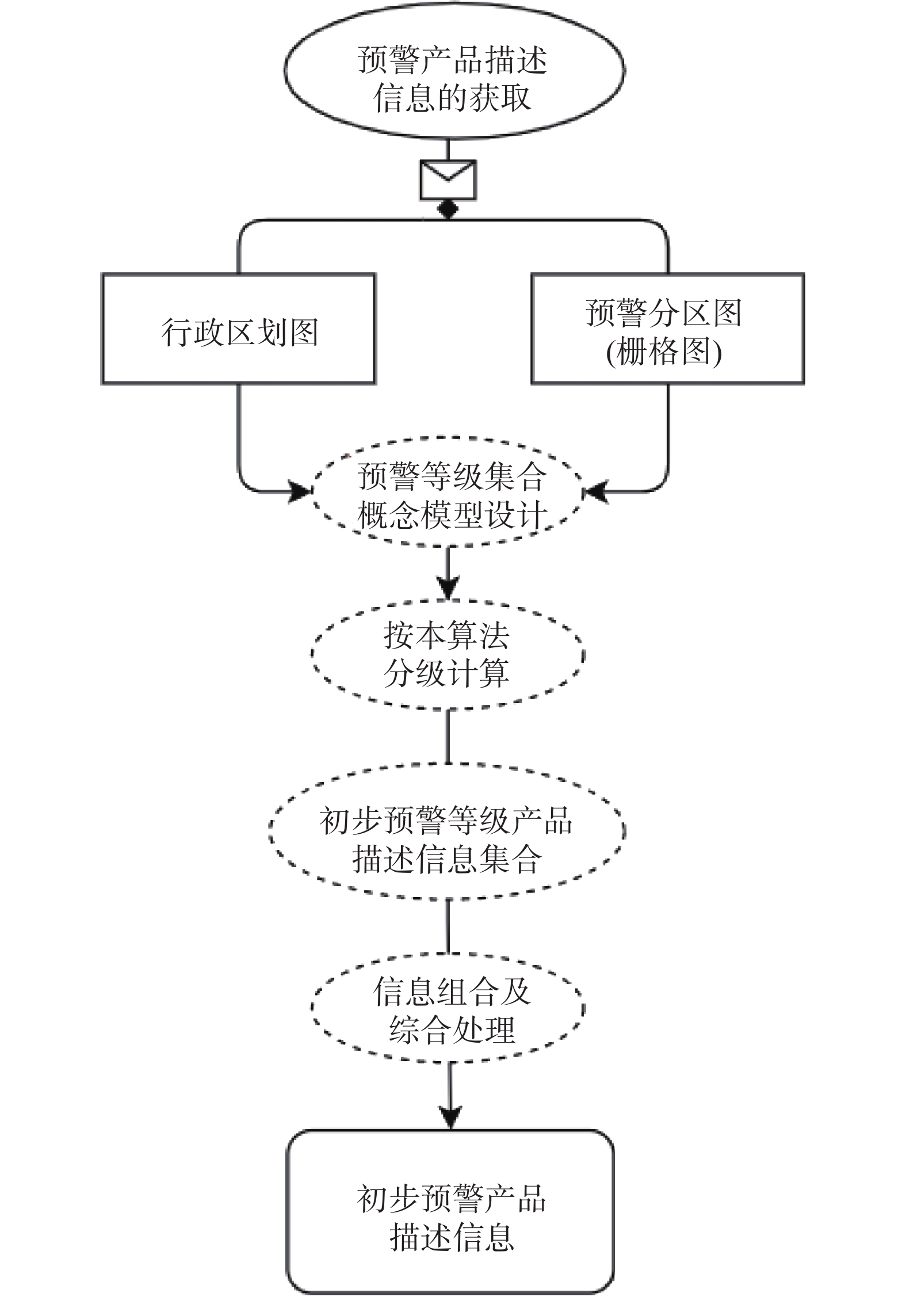
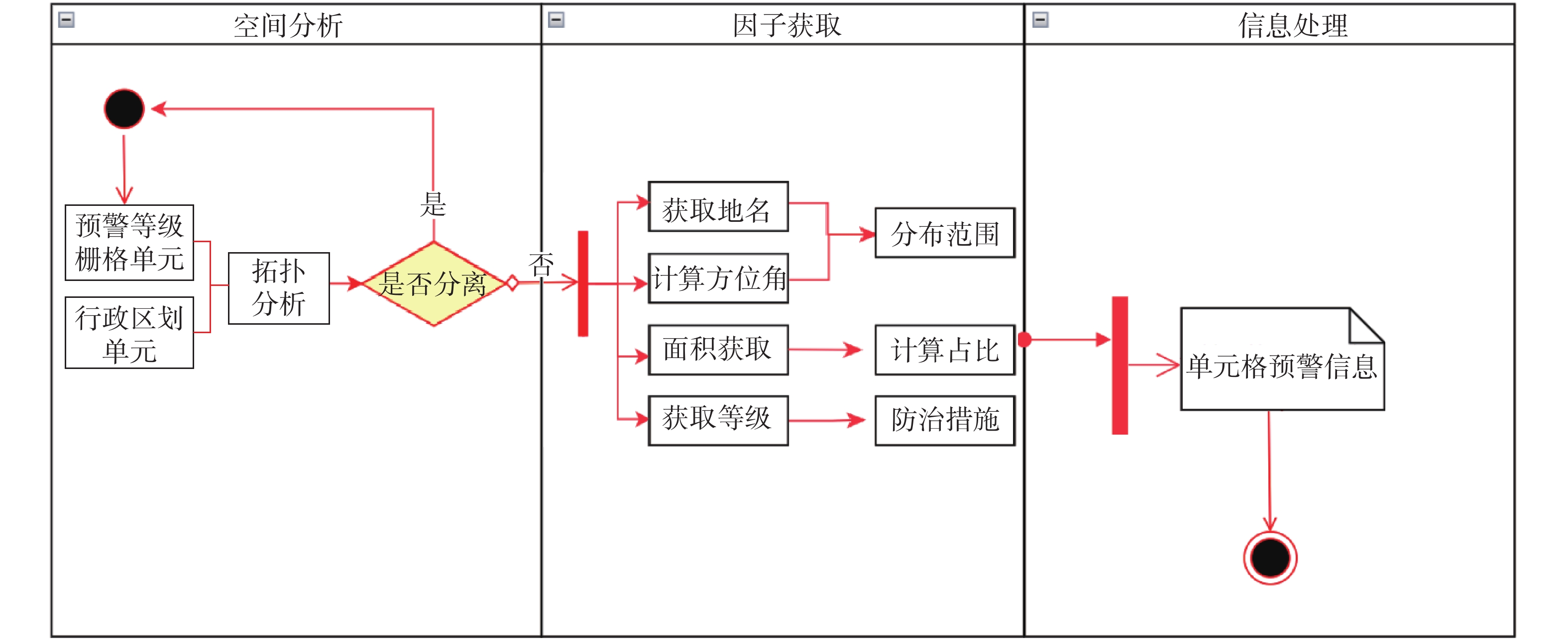
Figure 1.
Technical route
-
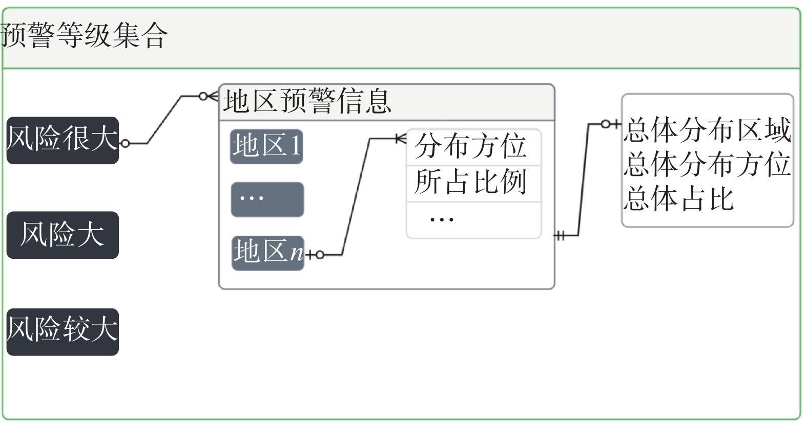
Figure 2.
Schematic diagram of the conceptual model of early warning level aggregation
-
Figure 3.
Schematic diagram of spatial discrimination
-
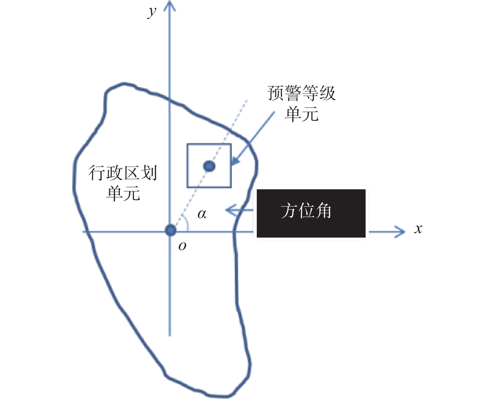
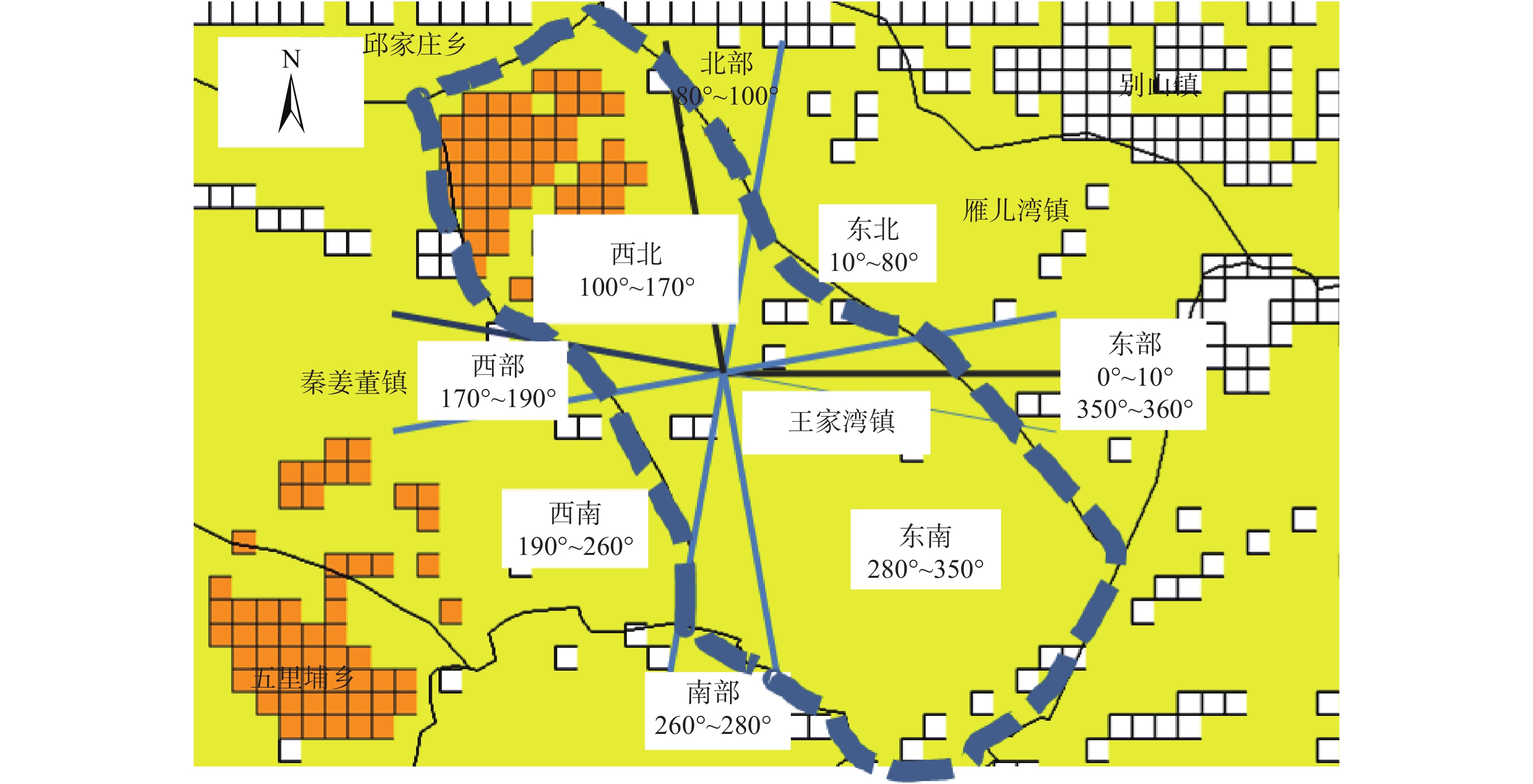
Figure 4.
Schematic diagram of the azimuth angle
-
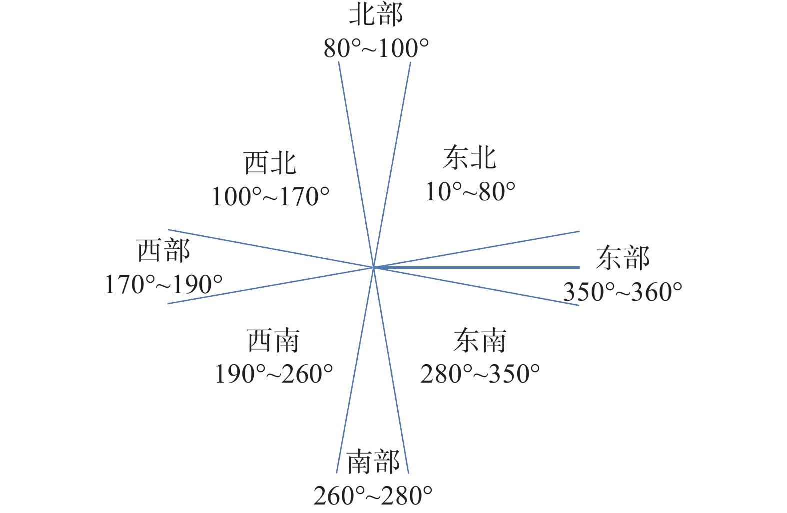
Figure 5.
The mapping relationship between azimuth and distribution direction
-
Figure 6.
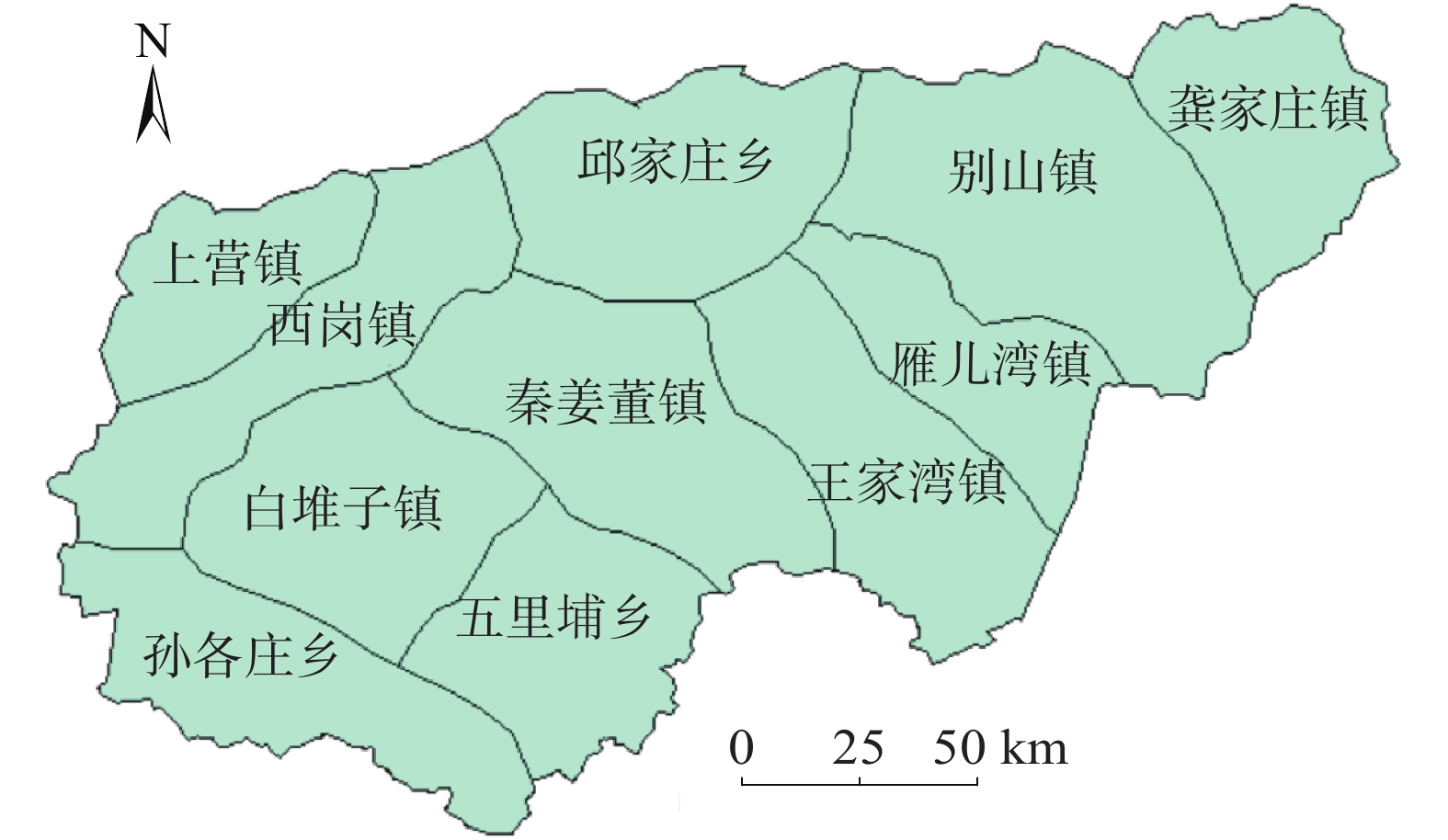
Geological hazard risk warning range in a region
-
Figure 7.
Geological disaster early warning zoning map on a certain day
-
Figure 8.
Module composition diagram
-
Figure 9.
The description information of the warning product
-
Figure 10.
Early warning product description information verification