
| China Geological Environment Monitoring Institute, China Geological Disaster Prevention Engineering Industry Association | Host |
| Citation: |
ZHOU Xiaolong, JIA Qiang, SHI Pengqing, HE Bin, GUO Fuyun, HU Wenbo, LI Panlong. Application of image-free control UAV aerial survey technology in emergency treatment of landslide-debris flow disaster in Lijie north hill,Zhouqu County[J]. The Chinese Journal of Geological Hazard and Control, 2022, 33(1): 107-116. doi: 10.16031/j.cnki.issn.1003-8035.2022.01-13

|
Application of image-free control UAV aerial survey technology in emergency treatment of landslide-debris flow disaster in Lijie north hill,Zhouqu County
-
Abstract
In recent years, UAV aerial survey technology has been widely used in the field of geological disaster prevention, especially in the emergency disposal of abrupt geological hazard. Image free UAV aerial survey technology can quickly obtain surveying and mapping data. Compared with traditional aerial survey methods, it greatly saves time cost and labor cost. In this paper, the DJI Phantom 4 RTK UAV is used to acquire and process the image free aerial survey data of landslide and debris flow disaster in Lijie North Hill landslide-debris flow disaster in Zhouqu County, Gansu Province. According to the aerial survey results, the relevant parameters such as landslide morphological characteristics and debris flow gully characteristics are quickly obtained, the signs of landslide deformation are analyzed, and the field survey data are used to evaluate and analyze the accuracy of image free aerial survey.The results show that the deformation signs, morphological characteristics and debris flow gully characteristics of landslide are consistent with the field, and the accuracy of verification points meets the data production specification of low altitude digital aerial photogrammetry (GH/Z 3003—2010). The result data can be used for the analysis of deformation characteristics of disaster body, rapid extraction of geometric parameters, and auxiliary analysis and evaluation of danger and disaster, It has a certain reference significance for the rapid acquisition of UAV mapping data in the emergency disposal of abrupt geological hazard.
-

-
References
[1] 陈文君, 陈锁忠, 张磊, 等. 突发性地质灾害应急处置系统的设计与实现[J]. 计算机应用与软件,2014,31(5):6 − 9. [CHEN Wenjun, CHEN Suozhong, ZHANG Lei, et al. Design and implementation of an emergency disposition system on sudden geological disasters[J]. Computer Applications and Software,2014,31(5):6 − 9. (in Chinese with English abstract) doi: 10.3969/j.issn.1000-386x.2014.05.002 [2] 刘传正. 重大突发地质灾害应急处置的基本问题[J]. 自然灾害学报,2006,15(3):24 − 30. [LIU Chuanzheng. Basic problem on emergency disposition of abrupt heavy geological disaster[J]. Journal of Natural Disasters,2006,15(3):24 − 30. (in Chinese with English abstract) doi: 10.3969/j.issn.1004-4574.2006.03.005 [3] 刘传正, 陈红旗, 韩冰, 等. 重大地质灾害应急响应技术支撑体系研究[J]. 地质通报,2010,29(1):147 − 156. [LIU Chuanzheng, CHEN Hongqi, HAN Bing, et al. Technical support system of emergency response for serious geo-hazards[J]. Geological Bulletin of China,2010,29(1):147 − 156. (in Chinese with English abstract) [4] 陈红旗, 徐永强, 庄茂国, 等. 地质灾害应急支撑体系建设基本问题分析[J]. 中国地质灾害与防治学报,2011,22(4):108 − 111. [CHEN Hongqi, XU Yongqiang, ZHUANG Maoguo, et al. Study on the construction of geological disaster emergency support system[J]. The Chinese Journal of Geological Hazard and Control,2011,22(4):108 − 111. (in Chinese with English abstract) doi: 10.3969/j.issn.1003-8035.2011.04.023 [5] 李俊峰, 张小趁, 刘红岩, 等. 突发地质灾害应急数值模拟浅析[J]. 中国地质灾害与防治学报,2016,27(2):154 − 161. [LI Junfeng, ZHANG Xiao chen, LIU Hongyan, et al. Numerical simulation technology analysis of geological disaster emergency[J]. The Chinese Journal of Geological Hazard and Control,2016,27(2):154 − 161. (in Chinese with English abstract) [6] CHOU T Y, YE M L, CHEN Y C, et al. Disaster monitoring and management by the unmanned aerial vehicle technology[J]. International archives of the photogrammetry, remote sensing and spatial information sciences,2010,38(7B):137 − 142. [7] DOMINICI, ALICANDRO, MASSIMI V. UAV photogrammetry in the post-earthquake scenario: Case studies in L'Aquila[J]. Geomatics Natural Hazards and Risk,2017,8(1):87 − 103. [8] SALVINI R, MASTROROCCO G, SEDDAIU M, et al. The use of an unmanned aerial vehicle for fracture mapping within a marble quarry (Carrara, Italy): Photogrammetry and discrete fracture network modelling[J]. Geomatics Natural Hazards & Risk,2017,8(1):34 − 52. [9] 曾涛, 杨武年, 简季. 无人机低空遥感影像处理在汶川地震地质灾害信息快速勘测中的应用[J]. 测绘科学,2009,34(增刊 2):64 − 65. [ZENG Tao, YANG Wunian, JIAN Ji. Applications of remote sensing images processing of unmanned air vehicle on the low attitude in quick acquirement of geological disasters information in Wenchuan earthquake[J]. Science of Surveying and Mapping,2009,34(Sup 2):64 − 65. (in Chinese with English abstract) [10] 高姣姣, 颜宇森, 盛新蒲, 等. 无人机遥感在西气东输管道地质灾害调查中的应用[J]. 水文地质工程地质,2010,37(6):126 − 129. [GAO Jiaojiao, YAN Yusen, SHENG Xinpu, et al. Application of UAV remote sensing in Geologic hazards survey along the project of west-east gas transmission[J]. Hydrogeology & Engineering Geology,2010,37(6):126 − 129. (in Chinese with English abstract) doi: 10.3969/j.issn.1000-3665.2010.06.025 [11] 朱婵莲, 姜啸, 焦龙进. 无人机在地质灾害应急抢险调查中的应用[J]. 中国金属通报,2020(6):184 − 185. [ZHU Chanlian, JIANG Xiao, JIAO Longjin. Application of UAV in geological disaster emergency investigation[J]. China Metal Bulletin,2020(6):184 − 185. (in Chinese with English abstract) [12] 郭晨, 许强, 彭双麒, 等. 无人机摄影测量技术在金沙江白格滑坡应急抢险中的应用[J]. 灾害学,2020,35(1):203 − 210. [GUO Chen, XU Qiang, PENG Shuangqi, et al. Application research of UAV photogrammetry technology in the emergency rescue of Baige landslide[J]. Journal of Catastrophology,2020,35(1):203 − 210. (in Chinese with English abstract) doi: 10.3969/j.issn.1000-811X.2020.01.038 [13] 李晓俊, 朱钱洪, 胡勇, 等. 多旋翼无人机山区城市地质灾害应急响应能力评估[J]. 地理空间信息,2019,17(3):12 − 15. [LI Xiaojun, ZHU Qianhong, HU Yong, et al. Geological disaster emergency response capability assessment of multirotor UAV in mountain city[J]. Geospatial information,2019,17(3):12 − 15. (in Chinese with English abstract) doi: 10.3969/j.issn.1672-4623.2019.03.004 [14] 叶伟林, 宿星, 魏万鸿, 等. 无人机航测系统在滑坡应急中的应用[J]. 测绘通报,2017(9):70 − 74. [YE Weilin, SU Xing, WEI Wanhong, et al. Application of UAV aerial photograph system in emergency rescue and relief for landslide[J]. Bulletin of Surveying and Mapping,2017(9):70 − 74. (in Chinese with English abstract) [15] 董秀军, 王栋, 冯涛. 无人机数字摄影测量技术在滑坡灾害调查中的应用研究[J]. 地质灾害与环境保护,2019,30(3):78 − 85. [DONG Xiujun, WANG Dong, FENG Tao. Research on the application of unmanned aerial vehicle digital photogrammetry in landslide disaster investigation[J]. Journal of Geological Hazards and Environment Preservation,2019,30(3):78 − 85. (in Chinese with English abstract) [16] 吴振宇, 马彦山. 无人机遥感技术在地质灾害调查中的应用[J]. 宁夏工程技术,2012,11(2):133 − 136. [WU Zhenyu, MA Yanshan. Application of remote sensing technology of UAV in the investigation of the geological disaster[J]. Ningxia Engineering Technology,2012,11(2):133 − 136. (in Chinese with English abstract) doi: 10.3969/j.issn.1671-7244.2012.02.010 [17] 崔红霞, 林宗坚, 孙杰. 无人机遥感监测系统研究[J]. 测绘通报,2005(5):11 − 14. [CUI Hongxia, LIN Zongjian, SUN Jie. Research on UAV remote sensing system[J]. Bulletin of Surveying and Mapping,2005(5):11 − 14. (in Chinese with English abstract) doi: 10.3969/j.issn.0494-0911.2005.05.003 [18] 晏磊, 吕书强, 赵红颖, 等. 无人机航空遥感系统关键技术研究[J]. 武汉大学学报(工学版),2004,37(6):67 − 70. [YAN Lei, LYU Shuqiang, ZHAO Hongying, et al. Research on key techniques of aerial remote sensing system for unmanned aerial vehicles[J]. Engineering Journal of Wuhan University,2004,37(6):67 − 70. (in Chinese with English abstract) [19] 雷添杰, 李长春, 何孝莹. 无人机航空遥感系统在灾害应急救援中的应用[J]. 自然灾害学报,2011,20(1):178 − 183. [LEI Tianjie, LI Changchun, HE Xiaoying. Application of aerial remote sensing of pilotless aircraft to disaster emergency rescue[J]. Journal of Natural Disasters,2011,20(1):178 − 183. (in Chinese with English abstract) [20] 马泽忠, 王福海, 刘智华, 等. 低空无人飞行器遥感技术在重庆城口滑坡堰塞湖灾害监测中的应用研究[J]. 水土保持学报,2011,25(1):253 − 256. [MA Zezhong, WANG Fuhai, LIU Zhihua, et al. Research of unmanned aerial vehicle remote sensing technique applied to monitor landslip and barrier lake hazard in Chengkou County of Chongqing[J]. Journal of Soil and Water Conservation,2011,25(1):253 − 256. (in Chinese with English abstract) [21] 尹鹏飞, 尹球, 陈兴峰, 等. 无人机航空遥感技术在震后灾情调查中的应用[J]. 激光与光电子学进展,2010,47(11):130 − 134. [YIN Pengfei, YIN Qiu, CHEN Xingfeng, et al. Unmanned aerial vehicle aerial remote sensing techniques and its application on post-earthquake disaster investigation[J]. Laser & Optoelectronics Progress,2010,47(11):130 − 134. (in Chinese with English abstract) [22] 韩文权, 任幼蓉, 赵少华. 无人机遥感在应对地质灾害中的主要应用[J]. 地理空间信息,2011,9(5):6 − 8. [HAN Wenquan, REN Yourong, ZHAO Shaohua. Primary usages of UAV remote sensing in geological disaster monitoring and rescuing[J]. Geoscience Information,2011,9(5):6 − 8. (in Chinese with English abstract) [23] 刘刚, 徐宏健, 马海涛, 等. 无人机航测系统在应急服务保障中的应用与前景[J]. 测绘与空间地理信息,2011,34(4):177 − 179. [LIU Gang, XU Hongjian, MA Haitao, et al. Unmanned aerial system applications and prospects in the protection of emergency services[J]. Geomatics & Spatial Information Technology,2011,34(4):177 − 179. (in Chinese with English abstract) doi: 10.3969/j.issn.1672-5867.2011.04.057 [24] 肖波, 朱兰艳, 黎剑, 等. 无人机低空摄影测量系统在地质灾害应急中的应用研究:以云南洱源特大山洪泥石流为例[J]. 价值工程,2013,32(4):281 − 282. [XIAO Bo, ZHU Lanyan, LI Jian, et al. Application of unmanned aerial vehicle photogram metric system in geological disaster: A case study in Er yuan devastating mudslides of Yunnan Province[J]. Value Engineering,2013,32(4):281 − 282. (in Chinese with English abstract) doi: 10.3969/j.issn.1006-4311.2013.04.155 [25] 嵇沛, 胡一凡, 王晨. 无人机低空航拍遥感在应急测绘保障中的应用[J]. 科技资讯,2016,14(24):2 − 3. [JI Pei, HU Yifan, WANG Chen. Application of UAV low altitude aerial remote sensing in emergency surveying and mapping support[J]. Science & Technology Information,2016,14(24):2 − 3. (in Chinese with English abstract) [26] 田彦. 无人机遥感技术在地质环境灾害监测中的应用探讨[J]. 环境与发展,2019,31(4):102 − 104. [TIAN Yan. Application of UAV remote sensing technology in geological environmental disaster monitoring[J]. Environment and Development,2019,31(4):102 − 104. (in Chinese with English abstract) [27] 周嵩. 无人机技术在地质灾害防治中的应用[J]. 冶金管理,2020(21):87 − 88. [ZHOU Song. Application of UAV technology in geological disaster prevention and control[J]. Metallurgical Management,2020(21):87 − 88. (in Chinese with English abstract) [28] 郭晨, 许强, 董秀军, 等. 无人机在重大地质灾害应急调查中的应用[J]. 测绘通报,2020(10):6 − 11. [GUO Chen, XU Qiang, DONG Xiujun, et al. Application of UAV photogrammetry technology in the emergency rescue of catastrophic geohazards[J]. Bulletin of Surveying and Mapping,2020(10):6 − 11. (in Chinese with English abstract) [29] 张允涛. 免相控无人机航摄系统在棚户区改造1∶500地形图中的应用[J]. 测绘通报,2019(增刊 1):295 − 297. [ZHANG Yuntao. Application of phase-free UAV aerial photography system in 1∶500 topographic map of shantytown reconstruction[J]. Bulletin of Surveying and Mapping,2019(Sup 1):295 − 297. (in Chinese with English abstract) [30] 石鼎. 免像控无人机在地形图测绘中的应用[J]. 北京测绘,2020,34(2):163 − 166. [SHI Ding. Application of UAV image free control in topographic map surveying[J]. Beijing Surveying and Mapping,2020,34(2):163 − 166. (in Chinese with English abstract) [31] 朱晓康, 魏景帅. 1∶500免像控无人机航测技术应用研究[J]. 地理空间信息,2019,17(2):22 − 26. [ZHU Xiaokang, WEI Jingshuai. Key technologies and application research on 1∶500 unmanned aerial vehicle photography without image control point[J]. Geospatial Information,2019,17(2):22 − 26. (in Chinese with English abstract) doi: 10.3969/j.issn.1672-4623.2019.02.006 [32] 范秀庆. 无人机免像控技术在地形图测量中的应用研究[J]. 测绘通报,2017(增刊 1):66 − 68. [FAN Xiuqing. Application of UAV image free control technique in topographic map surveying[J]. Bulletin Surveying and Mapping,2017(Sup 1):66 − 68. (in Chinese with English abstract) [33] 相涛, 栾元重, 许章平, 等. 基于Pix4Dmapper的无人机低空摄影测量数据处理[J]. 测绘与空间地理信息,2019,42(3):75 − 78. [XIANG Tao, LUAN Yuanzhong, XU Zhangping, et al. Unmanned aerial vehicle with low-altitude aerial photogrammetry data processing flow and precision analysis based on Pix4Dmapper[J]. Geomatics & Spatial Information Technology,2019,42(3):75 − 78. (in Chinese with English abstract) [34] 戴嵩, 魏冠军, 梁斌. 控制点布设方案对无人机精度测量的影响及其应用[J]. 中国地质灾害与防治学报,2021,32(5):113 − 120. [DAI Song, WEI Guanjun, LIANG Bin. Influence of control point number on UAV low-altitude photogrammetry and its application: A case study in subsidence monitoring of a tailing dam area in northwestern China[J]. The Chinese Journal of Geological Hazard and Control,2021,32(5):113 − 120. (in Chinese with English abstract) [35] 贾虎军, 王立娟, 范冬丽. 无人机载LiDAR和倾斜摄影技术在地质灾害隐患早期识别中的应用[J]. 中国地质灾害与防治学报,2021,32(2):60 − 65. [JIA Hujun, WANG Lijuan, FAN Dongli. The application of UAV LiDAR and tilt photography in the early identification of geo-hazards[J]. The Chinese Journal of Geological Hazard and Control,2021,32(2):60 − 65. (in Chinese with English abstract) [36] 张欢, 巨能攀, 陆渊, 等. 基于无人机的滑坡地形快速重建与稳定性分析[J]. 水文地质工程地质,2021,48(6):171 − 179. [ZHANG Huan, JU Nengpan, LU Yuan, et al. Rapid remodeling of three-dimensional terrain and stability analyses of landslide based on UAV[J]. Hydrogeology & Engineering Geology,2021,48(6):171 − 179. (in Chinese with English abstract) [37] 文宝萍, 王凡. 1965年烂泥沟滑坡前兆、高速远程运动及后期演化特征[J]. 水文地质工程地质,2021,48(6):72 − 80. [WEN Baoping, WANG Fan. Precursors and motion characteristics of the 1965 Lannigou rockslides and the subsequent evolution[J]. Hydrogeology & Engineering Geology,2021,48(6):72 − 80. (in Chinese with English abstract) -
Access History
Figures(9)

Export File
Citation
ZHOU Xiaolong, JIA Qiang, SHI Pengqing, HE Bin, GUO Fuyun, HU Wenbo, LI Panlong. Application of image-free control UAV aerial survey technology in emergency treatment of landslide-debris flow disaster in Lijie north hill,Zhouqu County[J]. The Chinese Journal of Geological Hazard and Control, 2022, 33(1): 107-116. doi: 10.16031/j.cnki.issn.1003-8035.2022.01-13
Format
Content
 DownLoad:

-
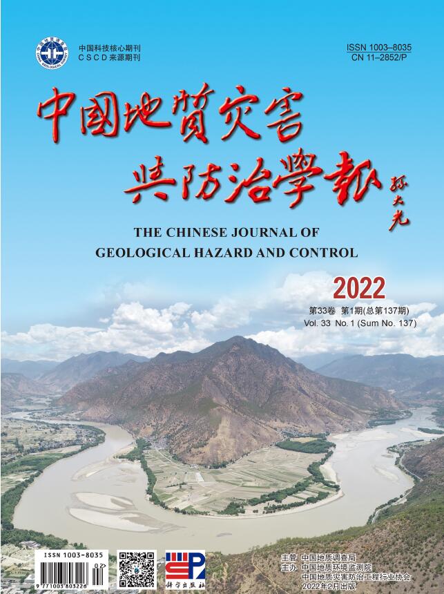
Figure 1.
UAV data acquisition process
-
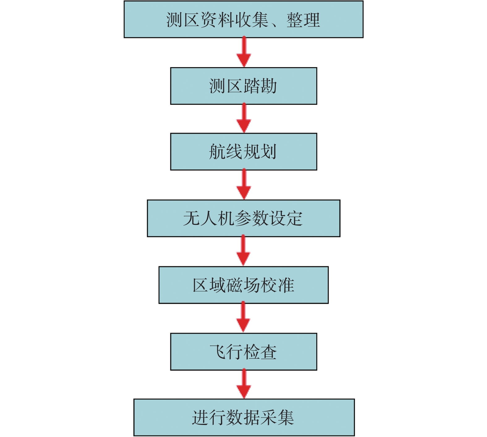
Figure 2.
UAV data processing flow
-
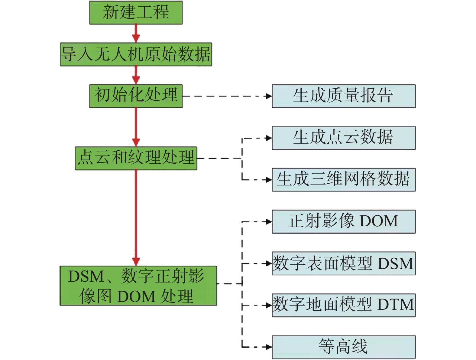
Figure 3.
Geographical location and elevation distribution map of the study area
-
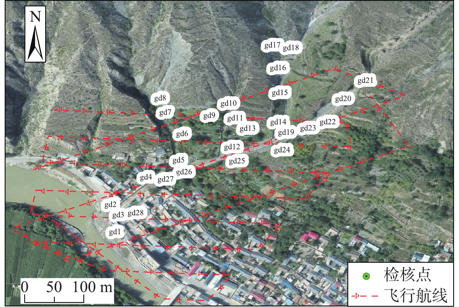
Figure 4.
UAV flight route and distribution of check points
-
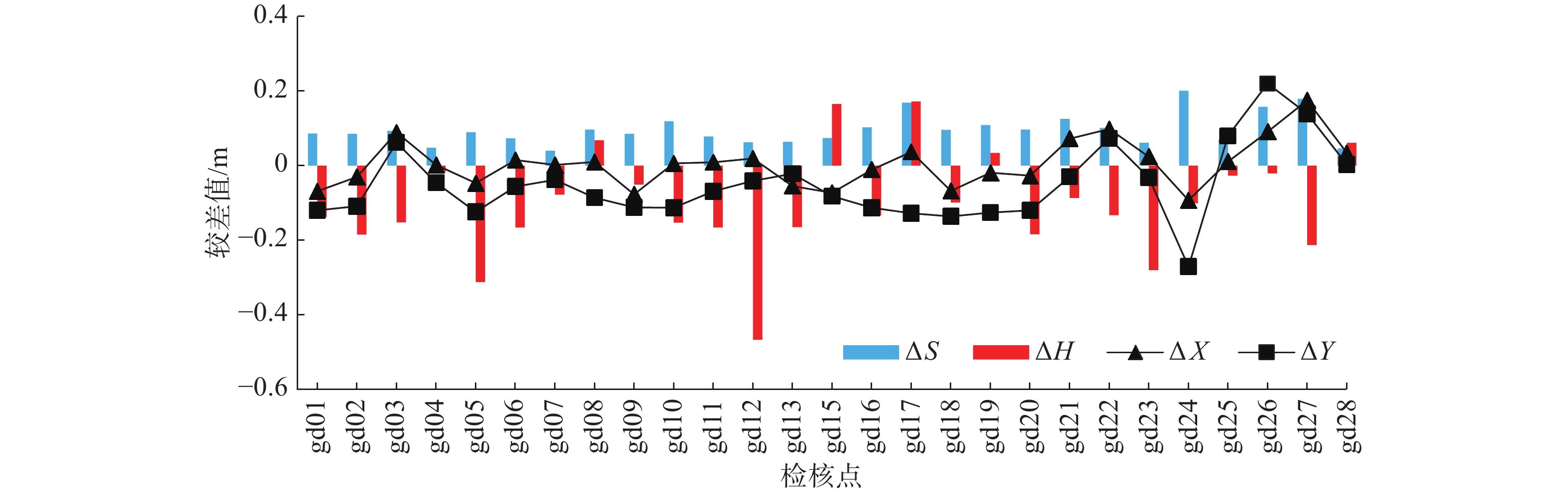
Figure 5.
Plane and elevation direction difference diagram
-
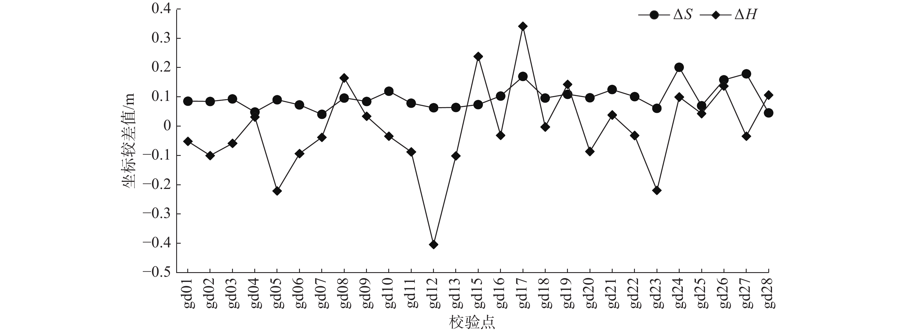
Figure 6.
Line chart of plane and elevation coordinate deviation
-
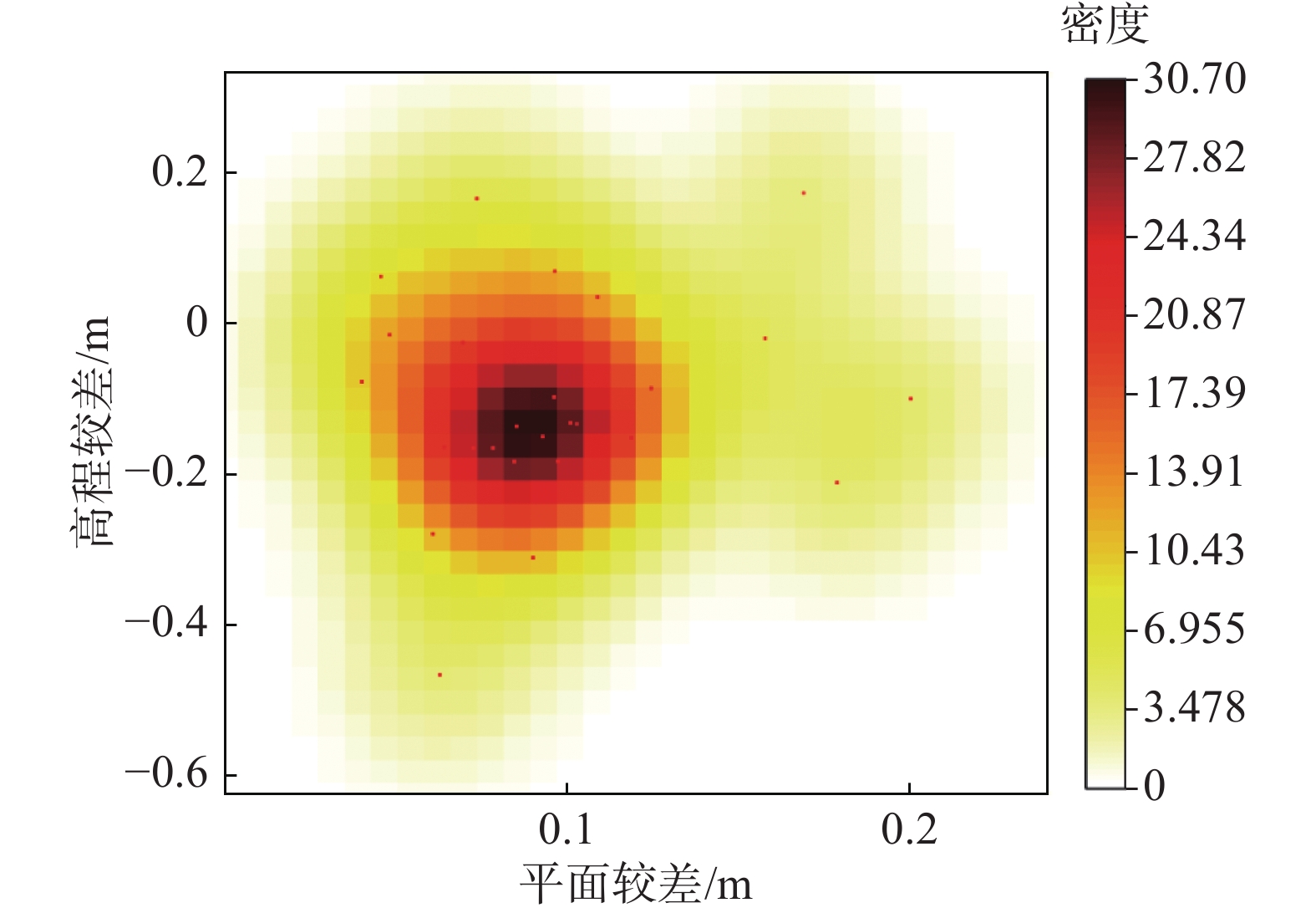
Figure 7.
Distribution of poor nuclear density
-
Figure 8.
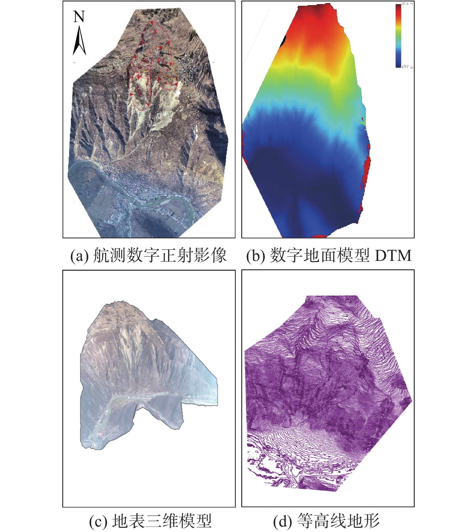
UAV aerial survey result data
-
Figure 9.
Geological hazard survey in Lijie north hill landslide in Zhouqu County