
| China Geological Environment Monitoring Institute, China Geological Disaster Prevention Engineering Industry Association | Host |
| Citation: |
MO Li, WANG Xianneng. Monitoring and analysis of ground and building settlement of deep trough in Houhai based on PS-InSAR technology[J]. The Chinese Journal of Geological Hazard and Control, 2023, 34(1): 68-74. doi: 10.16031/j.cnki.issn.1003-8035.202110029

|
Monitoring and analysis of ground and building settlement of deep trough in Houhai based on PS-InSAR technology
-
Abstract
The Houhai area in Nanshan District of Shenzhen is the base of the headquarters building, where the Shenzhen fault zone and the Pearl River Mouth fault zone meet here. In this region, the bedrock is buried deeply, the faults are well developed, and there is huge thick weathered deep trough. Thus, overlength pile foundation is used in high-rise buildings. In this study, the permanent scatterers interferometric synthetic aperture radar technique was used to monitor the settlement of ground and structures in houhai Deep trough research area, Nanshan District, Shenzhen. The monitoring results show that the settlement of buildings and other structures on deep trough is relatively stable, and the pile foundation construction technology in Houhai research area is safe and effective at present. The grassland of Shenzhen Bay Park and its surrounding areas have a large amount of settlement, which is mainly caused by the settlement of soft land reclaimed from the sea. Compared with the traditional monitoring technology, the monitoring accuracy of InSAR technology meets the requirements. The InSAR technology has advantages for large-scale, low-cost, high-precision and high-efficiency deformation monitoring.
-

-
References
[1] 代志宏,卢鹏,张志芳,等. 基于PS-InSAR技术的南宁地表沉降监测与分析[J]. 大地测量与地球动力学,2021,41(5):491 − 496. [DAI Zhihong,LU Peng,ZHANG Zhifang,et al. Surface subsidence monitoring and analysis of Nanning based on PS-InSAR technology[J]. Journal of Geodesy and Geodynamics,2021,41(5):491 − 496. (in Chinese with English abstract) [2] 叶凯,金典琦,张勇,等. 基于PS-InSAR技术的深圳北站表面位移监测研究[J]. 测绘地理信息,2021,46(3):29 − 32. [YE Kai,JIN Dianqi,ZHANG Yong,et al. Surface deformation monitoring of Shenzhen north station using PS-InSAR technology[J]. Journal of Geomatics,2021,46(3):29 − 32. (in Chinese with English abstract) [3] 李晓恩,周亮,苏奋振,等. InSAR技术在滑坡灾害中的应用研究进展[J]. 遥感学报,2021,25(2):614 − 629. [LI Xiaoen,ZHOU Liang,SU Fenzhen,et al. Application of InSAR technology in landslide hazard:Progress and prospects[J]. National Remote Sensing Bulletin,2021,25(2):614 − 629. (in Chinese with English abstract) [4] 潘光永,陶秋香,陈洋,等. 基于SBAS-InSAR的山东济阳矿区沉降监测与分析[J]. 中国地质灾害与防治学报,2020,31(4):100 − 106. [PAN Guangyong,TAO Qiuxiang,CHEN Yang,et al. Monitoring and analysis of sedimentation in Jiyang mining area of Shandong Province based on SBAS-InSAR[J]. The Chinese Journal of Geological Hazard and Control,2020,31(4):100 − 106. (in Chinese with English abstract) [5] 魏纪成,张红霞,白泽朝,等. 融合D-InSAR与PS-InSAR的神东矿区开采沉陷监测方法[J]. 金属矿山,2019(10):55 − 60. [WEI Jicheng,ZHANG Hongxia,BAI Zechao,et al. Integrated monitoring method of the mining subsidence of Shendong mining area based on D-InSAR and PS-InSAR technology[J]. Metal Mine,2019(10):55 − 60. (in Chinese with English abstract) [6] 李军,褚宏亮,李滨,等. 基于高分影像与InSAR解译的西藏林芝则隆弄高位链式地质灾害发育特征分析[J]. 中国地质灾害与防治学报,2021,32(3):42 − 50. [LI Jun,CHU Hongliang,LI Bin,et al. Analysis of development characteristics of high-elevationchain geological hazard in Zelongnong, Nyingchi, Xizang based on high resolution image and InSAR interpretation[J]. The Chinese Journal of Geological Hazard and Control,2021,32(3):42 − 50. (in Chinese with English abstract) [7] 潘建平,邓福江,徐正宣,等. 基于轨道精炼控制点精选的极艰险区域时序InSAR地表形变监测[J]. 中国地质灾害与防治学报,2021,32(5):98 − 104. [PAN Jianping,DENG Fujiang,XU Zhengxuan,et al. Time series InSAR surface deformation monitoring in extremely difficult area based on track refining control points selection[J]. The Chinese Journal of Geological Hazard and Control,2021,32(5):98 − 104. (in Chinese with English abstract) [8] 洪兆阳,金双根. 利用时序PS-InSAR监测青藏高原冻土区地表形变[J]. 测绘通报,2021(1):35 − 40. [HONG Zhaoyang,JIN Shuanggen. Permafrost deformation in Qinghai-Xizang plateau time-series PS-InSAR[J]. Bulletin of Surveying and Mapping,2021(1):35 − 40. (in Chinese with English abstract) [9] 许军强,马涛,卢意恺,等. 基于SBAS-InSAR技术的豫北平原地面沉降监测[J]. 吉林大学学报(地球科学版),2019,49(4):1182 − 1191. [XU Junqiang,MA Tao, LU Yikai,et al. Land subsidence monitoring in north Henan plain based on SBAS-InSAR technology[J]. Journal of Jilin University (Earth Science Edition),2019,49(4):1182 − 1191. (in Chinese with English abstract) [10] FERRETTI A,PRATI C,ROCCA F. Nonlinear subsidence rate estimation using permanent scatterers in differential SAR interferometry[J]. IEEE Transactions on Geoscience and Remote Sensing,2000,38(5):2202 − 2212. doi: 10.1109/36.868878 [11] FERRETTI A,PRATI C,ROCCA F. Permanent scatterers in SAR interferometry[J]. IEEE Transactions on Geoscience and Remote Sensing,2001,39(1):8 − 20. doi: 10.1109/36.898661 [12] 范军,左小清,李涛,等. PS-InSAR和SBAS-InSAR技术对昆明主城区地面沉降监测的对比分析[J]. 测绘工程,2018,27(6):50 − 58. [FAN Jun,ZUO Xiaoqing,LI Tao,et al. Analysis and comparison of PS-InSAR and SBAS-InSAR for ground subsidence monitoring in the main city of Kunming[J]. Engineering of Surveying and Mapping,2018,27(6):50 − 58. (in Chinese with English abstract) [13] 《深圳地质》编写组. 深圳地质[M]. 北京: 地质出版社, 2009 Editorial group of Shenzhen Geology. Shenzhen Geological[M]. Beijing: Geological Publishing House, 2009. (in Chinese) [14] 雷斌,李超,童心,等. 灌注桩钢筋笼箍筋自动弯箍施工技术[J]. 建筑施工,2020,49(增刊 1):786 − 789. [LEI Bin,LI Chao,TONG Xin,et al. Construction technology of automatic bending hoop for reinforcing cage stirrup of cast-in-place piles[J]. Construction Technology,2020,49(Sup 1):786 − 789. (in Chinese with English abstract) [15] 夏小裕,王哲奇. PS-InSAR 与 DS-InSAR 监测城市地面沉降的精度检验与分析[J]. 海洋测绘,2020,40(4):65 − 71. [XIA Xiaoyu,WANG Zheqi. Accuracy test and analysis of PS-InSAR and DS-InSAR monitoring urban land subsidence[J]. Hydrographic Surveying and Charting,2020,40(4):65 − 71. (in Chinese with English abstract) [16] 中华人民共和国住房和城乡建设部. 工程测量标准: GB 50026—2020[S]. 北京: 中国计划出版社, 2021. Ministry of Housing and Urban-Rural Development of the People’s Republic of China. Standard for engineering surveying: GB 50026—2020[S]. Beijing: China Planning Press, 2021. (in Chinese) -
Access History
Figures(6)
Tables(4)

Export File
Citation
MO Li, WANG Xianneng. Monitoring and analysis of ground and building settlement of deep trough in Houhai based on PS-InSAR technology[J]. The Chinese Journal of Geological Hazard and Control, 2023, 34(1): 68-74. doi: 10.16031/j.cnki.issn.1003-8035.202110029
Format
Content
 DownLoad:

-
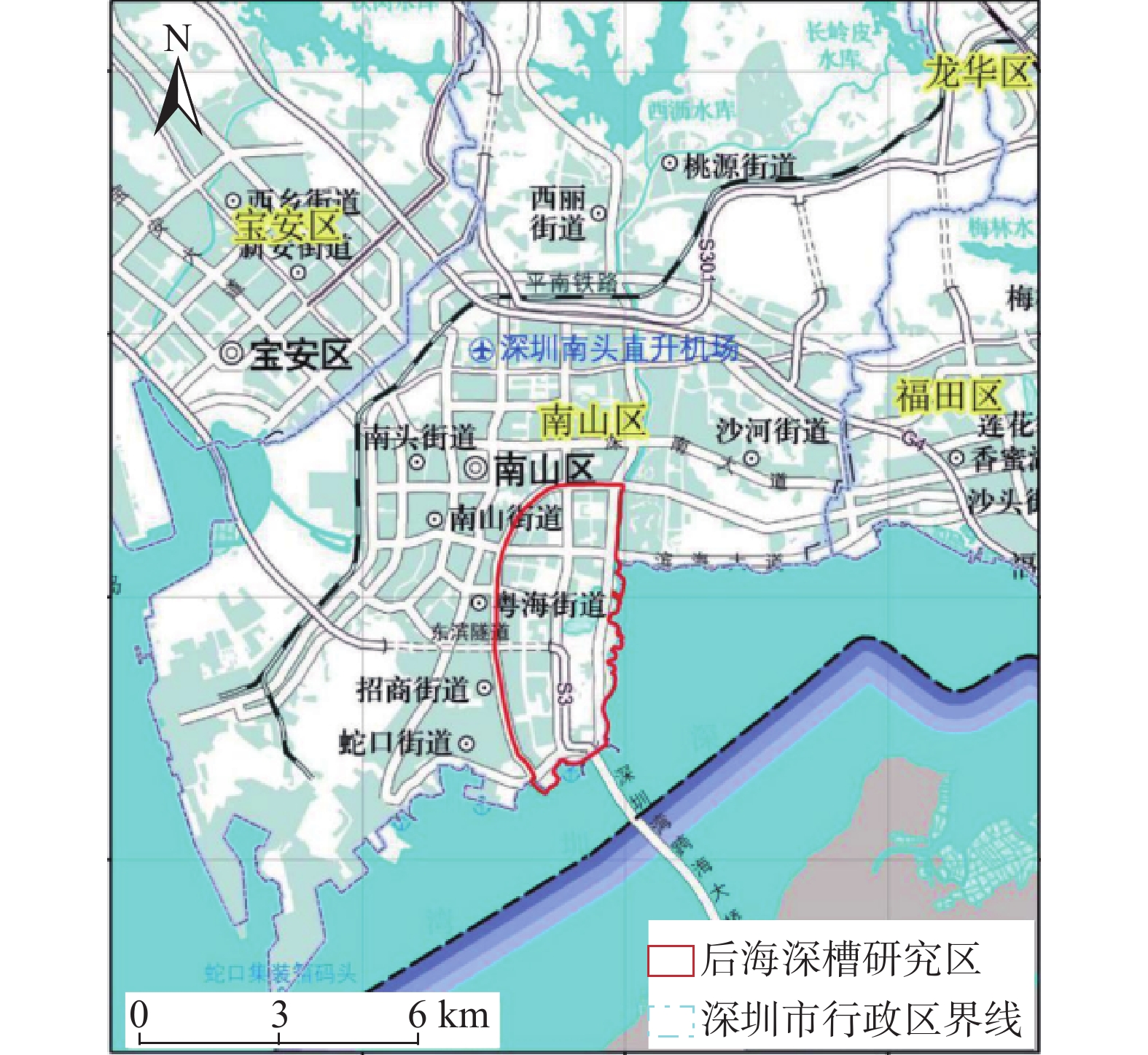
Figure 1.
Study area
-
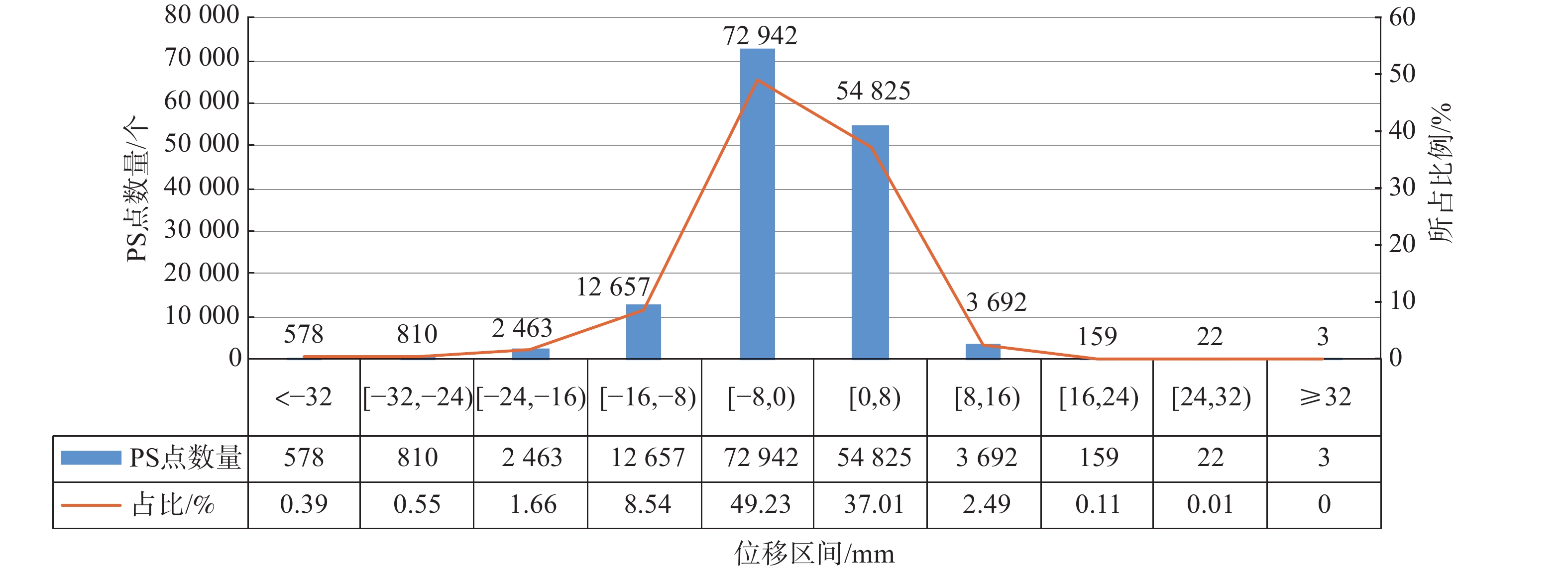
Figure 2.
Cumulative settlement statistics
-
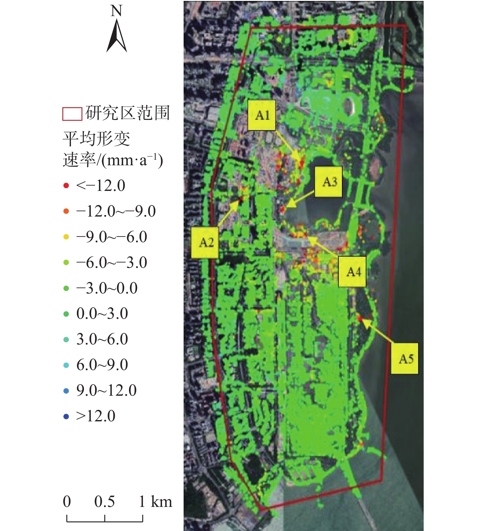
Figure 3.
Deep trough distribution and location of key monitoring points
-
Figure 4.
Large deformation region
-
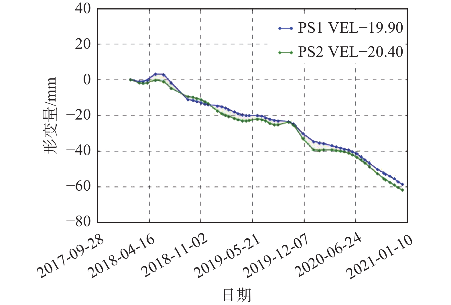
Figure 5.
Deformation-time curve of A2
-
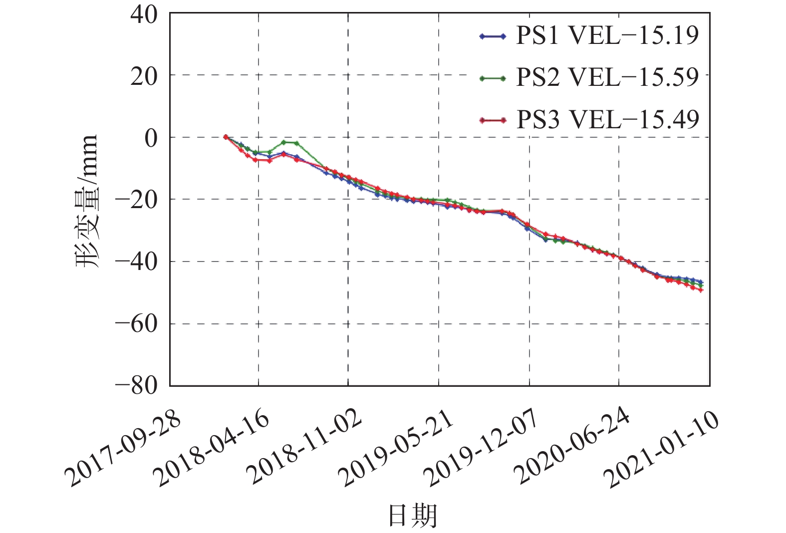
Figure 6.
Deformation-time cure of A5