
| China Geological Environment Monitoring Institute, China Geological Disaster Prevention Engineering Industry Association | Host |
| Citation: |
BI Rui, GAN Shu, LI Raobo, HU Lin. Application research of unmanned aerial vehicle remote sensing detection for 3D terrain modeling and feature analysis of debris flow gullies in complex mountainous area of Dongchuan[J]. The Chinese Journal of Geological Hazard and Control, 2021, 32(3): 91-100. doi: 10.16031/j.cnki.issn.1003-8035.2021.03-12

|
Application research of unmanned aerial vehicle remote sensing detection for 3D terrain modeling and feature analysis of debris flow gullies in complex mountainous area of Dongchuan
-
Abstract
Taking the debris flow gully of the tributary of the Dabaini River on the left bank of the middle reaches of the Xiaojiang River Basin in Dongchuan District, Yunnan Province as the research object, the surface landform data of the debris flow gully was collected by Unmanned Aerial Vehicle (UAV) remote sensing technology. This paper proposes a method of extracting the control points of the same-named objects in combination with the ground three-dimensional laser scanning modeling data to realize the absolute orientation of UAV image data. Through Smart3D image data processing, a three-dimensional terrain model of the study area is constructed to obtain digital orthophoto map (DOM), digital surface model (DSM) and high-density matching point cloud. The point cloud data is processed using the Irregular Triangle Network progressive encryption technology in PhotoScan software to obtain a digital elevation model (DEM) with a resolution of 0.5 m. Combined with the relevant terrain analysis modules in ArcGIS and Cloud Compare, the terrain characteristics of this section of debris flow valley area can be analyzed. The technical route and method used in the modeling and analysis of debris flow gully terrain based on UAV remote sensing are of important empirical case reference value and practical guiding significance for qualitative and quantitative detection of geological disasters in the plateau complex mountain area and their monitoring and prevention.
-

-
References
[1] 李家春, 宋宗昌, 侯少梁, 等. 北斗高精度定位技术在边坡变形监测中的应用[J]. 中国地质灾害与防治学报,2020,31(1):70 − 74. [LI Jiachun, SONG Zongchang, HOU Shaoliang, et al. Application of Beidou high-precision positioningtechnology in slope deformation monitoring[J]. The Chinese Journal of Geological Hazard and Control,2020,31(1):70 − 74. (in Chinese with English abstract) [2] 李明威, 唐川, 陈明, 等. 汶川震区北川县泥石流流域崩滑体时空演变特征[J]. 水文地质工程地质,2020,47(3):182 − 190. [LI Mingwei, TANG Chuan, CHEN Ming, et al. Spatio-temporal evolution characteristics of landslides in debris flow catchment in Beichuan County in the Wenchuan earthquake zone[J]. Hydrogeology & Engineering Geology,2020,47(3):182 − 190. (in Chinese with English abstract) [3] 赵富萌, 张毅, 孟兴民, 等. 基于小基线集雷达干涉测量的中巴公路盖孜河谷地质灾害早期识别[J]. 水文地质工程地质,2020,47(1):142 − 152. [ZHAO Fumeng, ZHANG Yi, MENG Xingmin, et al. Early identification of geological hazards in the Gaizi valley near the Karakoran Highway based on SBAS-InSAR technology[J]. Hydrogeology & Engineering Geology,2020,47(1):142 − 152. (in Chinese with English abstract) [4] 杨明生. 长时序多源遥感的滑坡变化监测方法研究[D]. 北京: 中国科学院大学(中国科学院遥感与数字地球研究所), 2018. YANG Mingsheng. Method research on landslide Change monitoring based on Long Time Series Multi-source remote sensing [D]. Beijing: University of Chinese Academy of Science(Institute of Remote Sensing and Digital Earth Chinese Academy of Sciences), 2018. (in Chinese) [5] 范敏, 孙小飞, 苏凤环, 等. 国产高分卫星数据在西南山区地质灾害动态监测中的应用[J]. 国土资源遥感,2017,29(增刊1):85 − 89. [FAN Min, SUN Xiaofei, SU Fenghuan, et al. Application analysis of remote sensing dynamic monitoring for geological hazards in southwest mountainous areas using domestic high resolution satellite data[J]. Remote Sensing for Land and Resources,2017,29(Sup1):85 − 89. (in Chinese with English abstract) [6] 葛大庆, 戴可人, 郭兆成, 等. 重大地质灾害隐患早期识别中综合遥感应用的思考与建议[J]. 武汉大学学报(信息科学版),2019,44(7):949 − 956. [GE Daqing, DAI Keren, GUO Zhaocheng, et al. Early identification of serious geological hazards with integrated remote sensing technologies: Thoughts and recommendations[J]. Geomatics and Information Science of Wuhan University,2019,44(7):949 − 956. (in Chinese with English abstract) [7] 康玉霄, 桑文刚, 李娜, 等. 无人机低空摄影测量数据处理及应用[J]. 测绘通报,2017(增刊1):62 − 65. [KANG Yuxiao, SANG Wengang, LI Na, et al. Unmanned aerial vehicle low-altitude photogrammetry data processingand application[J]. Bulletin of Surveying and Mapping,2017(Sup1):62 − 65. (in Chinese with English abstract) [8] 毕凯, 李英成, 丁晓波, 等. 轻小型无人机航摄技术现状及发展趋势[J]. 测绘通报,2015(3):27 − 31. [BI Kai, LI Yingcheng, DING Xiaobo, et al. Aerial photogrammetric technology of light small UAV: Statusand trend of development[J]. Bulletin of Surveying and Mapping,2015(3):27 − 31. (in Chinese with English abstract) [9] 郭学飞, 焦润成, 曹颖, 等. 倾斜摄影测量技术在崩塌隐患调查评价中的应用[J]. 中国地质灾害与防治学报,2020,31(1):65 − 69. [GUO Xuefei, JIAO Runcheng, CAO Ying, et al. Application of oblique photography in the investigationpotential of rockfall[J]. The Chinese Journal of Geological Hazard and Control,2020,31(1):65 − 69. (in Chinese with English abstract) [10] HUANG H F, SONG K, YI W, et al. Use of multi-source remote sensing images to describe the sudden Shanshucao landslide in the Three Gorges Reservoir, China[J]. Bulletin of Engineering Geology and the Environment,2019,78(4):2591 − 2610. [11] JI H W, LUO X Q. 3D scene reconstruction of landslide topography based on data fusion between laser point cloud and UAV image[J]. Environmental Earth Sciences,2019,78(17):1 − 12. [12] 巨袁臻. 基于无人机摄影测量技术的黄土滑坡早期识别研究[D]. 成都: 成都理工大学, 2017. JU Yuanzhen. Early recognition of loess landslide based on UAV photogrammetry—A case study of Heifang Terrace [D]. Chengdu: Chengdu University of Technology, 2017. (in Chinese) [13] 黄海峰, 林海玉, 吕奕铭, 等. 基于小型无人机遥感的单体地质灾害应急调查方法与实践[J]. 工程地质学报,2017,25(2):447 − 454. [HUANG Haifeng, LIN Haiyu, LYU Yiming, et al. Micro Unmanned Aerial Vehicle Based Remote Sensing Method and Application for Emergency Survey of Individual Geohazard[J]. Journal of Engineering Geology,2017,25(2):447 − 454. (in Chinese with English abstract) [14] 王庆国, 赵海, 李健平. 地面激光点云与航空影像相结合的滑坡监测[J]. 测绘通报,2019(4):99 − 102. [WANG Qingguo, ZHAO Hai, LI Jianping. Landslide monitoring by merging ground laser point cloud and aerial image[J]. Bulletin of Surveying and Mapping,2019(4):99 − 102. (in Chinese with English abstract) [15] SOTIRIS V, GEORGE P, ATHANASSIOS G. Mapping an earthquake-induced landslide based on UAV imagery; case study of the 2015 Okeanos landslide, Lefkada, Greece[J]. Engineering Geology, 2018, 245: 141-152. [16] DARREN T, ARKO L, STEVEN D J. Time series analysis of landslide dynamics using an Unmanned Aerial Vehicle (UAV)[J]. Remote Sensing,2015,7(2):1736 − 1757. [17] 于辉, 甘淑, 杨敏, 等. 东川小江流域典型沟谷泥石流迹地环境综合遥感解译分析[J]. 地质灾害与环境保护,2017,28(3):96 − 100. [YU Hui, GAN Shu, YANG Min, et al. Comprehensive remote sensing interpretation analysis of typical gully debris flow environment of Xiaojiang River Basin in Dongchuan Country[J]. Journal of Geological Hazards and Environment Preservation,2017,28(3):96 − 100. (in Chinese with English abstract) doi: 10.3969/j.issn.1006-4362.2017.03.019 [18] 杨敏, 甘淑, 袁希平, 等. 复杂带状地形条件下的地面三维激光扫描点云数据采集与配准处理试验[J]. 测绘通报,2018(5):35 − 40. [YANG Min, GAN Shu, YUAN Xiping, et al. Study on data acquisition and registration experiment of terrestrial laser scanning point clouds under complicated banded terrain condition[J]. Bulletin of Surveying and Mapping,2018(5):35 − 40. (in Chinese with English abstract) [19] FRANCISCO A V, FERNANDO C R, PATRICIO M C, et al. Reconstruction of extreme topography from UAV structure from motion photogrammetry[J]. Measurement,2018,121:127 − 138. -
Access History

Figures(11)
Tables(2)

Export File
Citation
BI Rui, GAN Shu, LI Raobo, HU Lin. Application research of unmanned aerial vehicle remote sensing detection for 3D terrain modeling and feature analysis of debris flow gullies in complex mountainous area of Dongchuan[J]. The Chinese Journal of Geological Hazard and Control, 2021, 32(3): 91-100. doi: 10.16031/j.cnki.issn.1003-8035.2021.03-12
Format
Content
 DownLoad:


-
Figure 1.
Location of study area
-
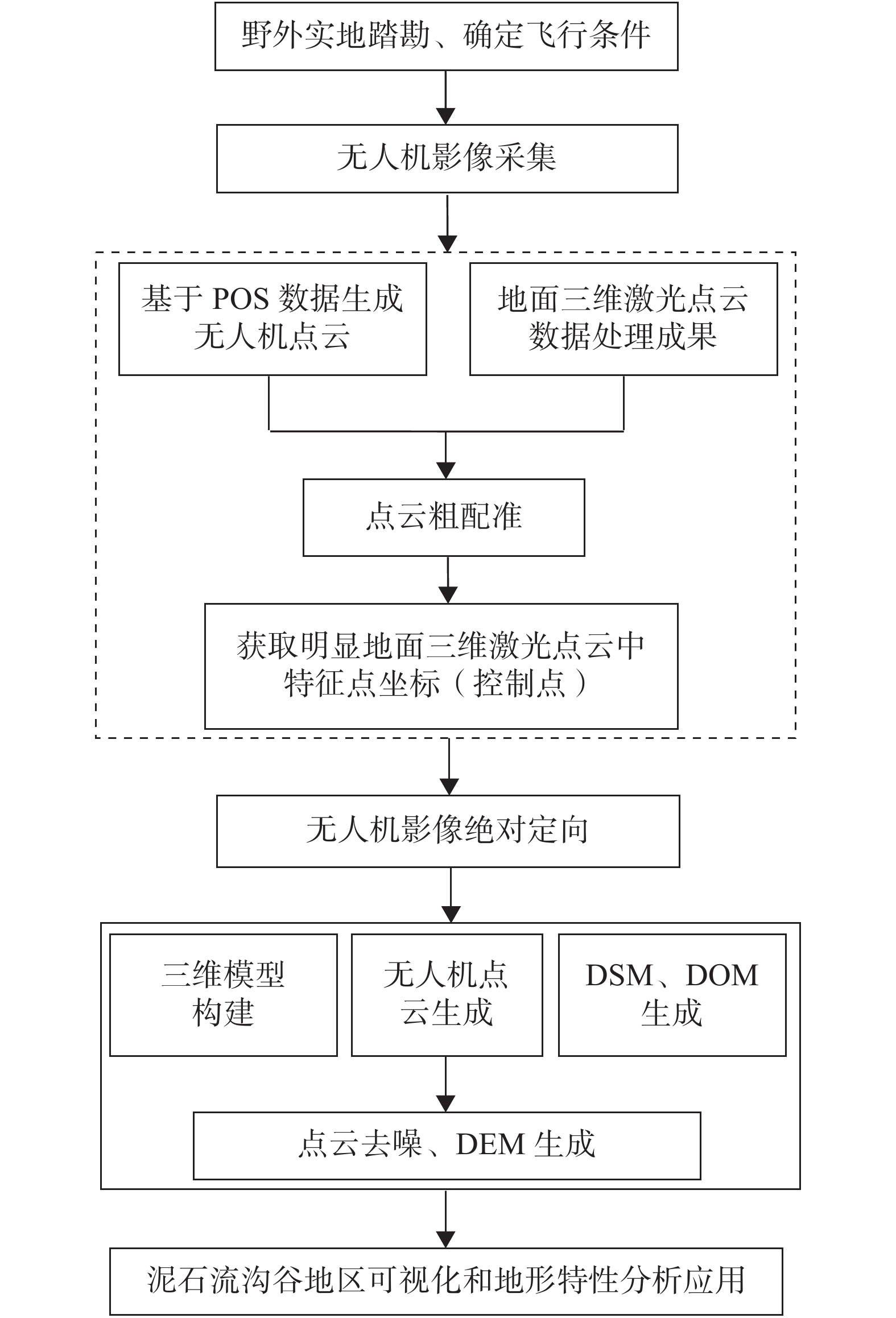
Figure 2.
Technical route
-
Figure 3.
UAV routes are laid out
-
Figure 4.
Coarse registration of point cloud data
-
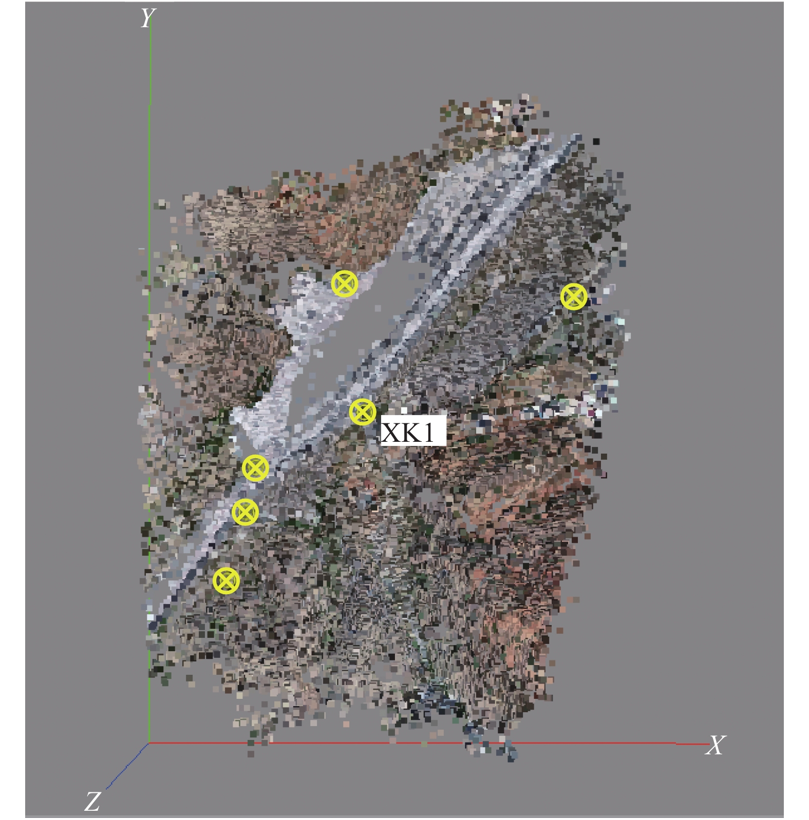
Figure 5.
Control points arrangement
-
Figure 6.
UAV images data results
-
Figure 7.
UAV point cloud denoising
-
Figure 8.
UAV DEM and accuracy compariso
-
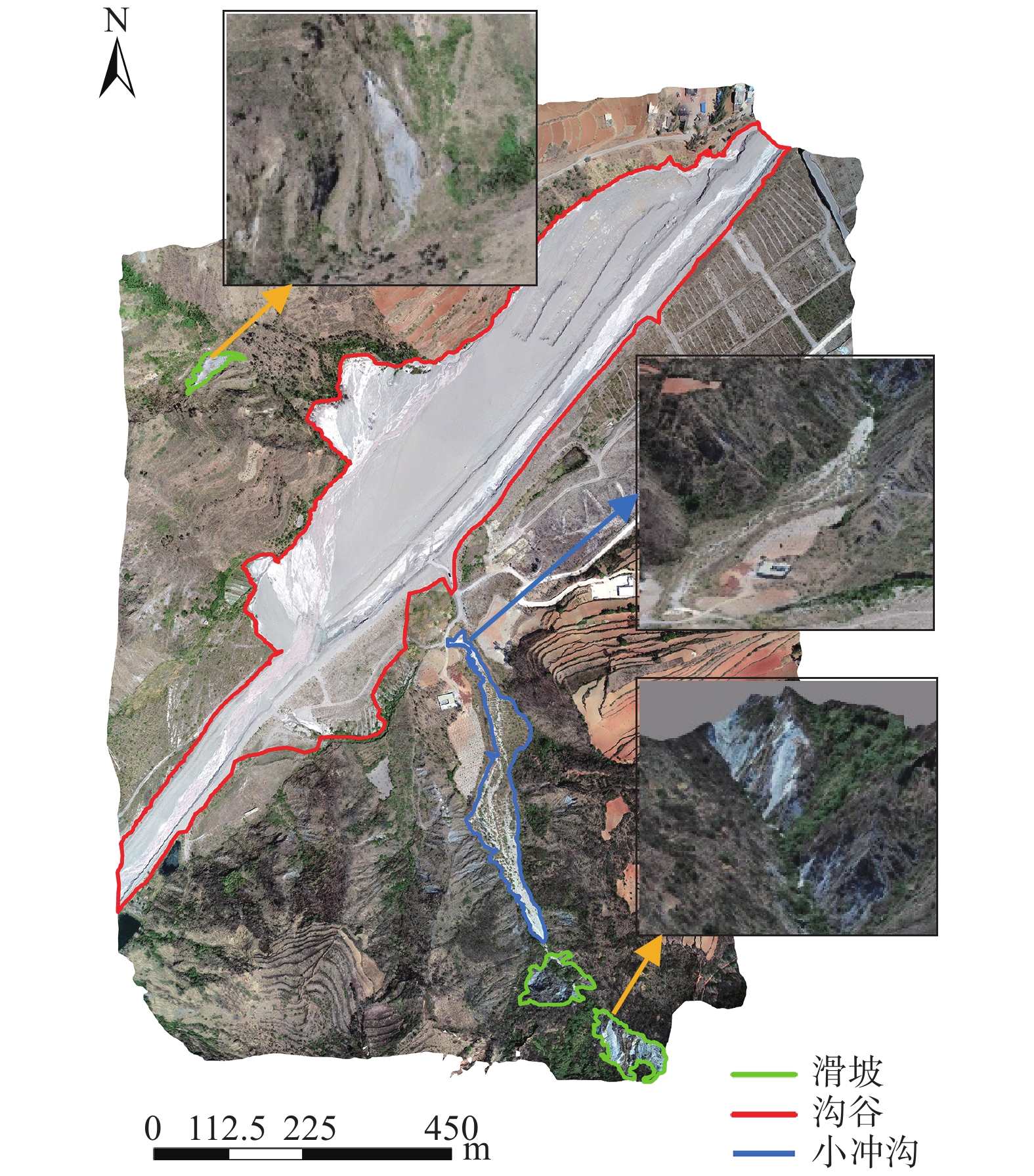
Figure 9.
Disaster bodies visual interpretation
-
Figure 10.
Slope slope direction analysis chart
-
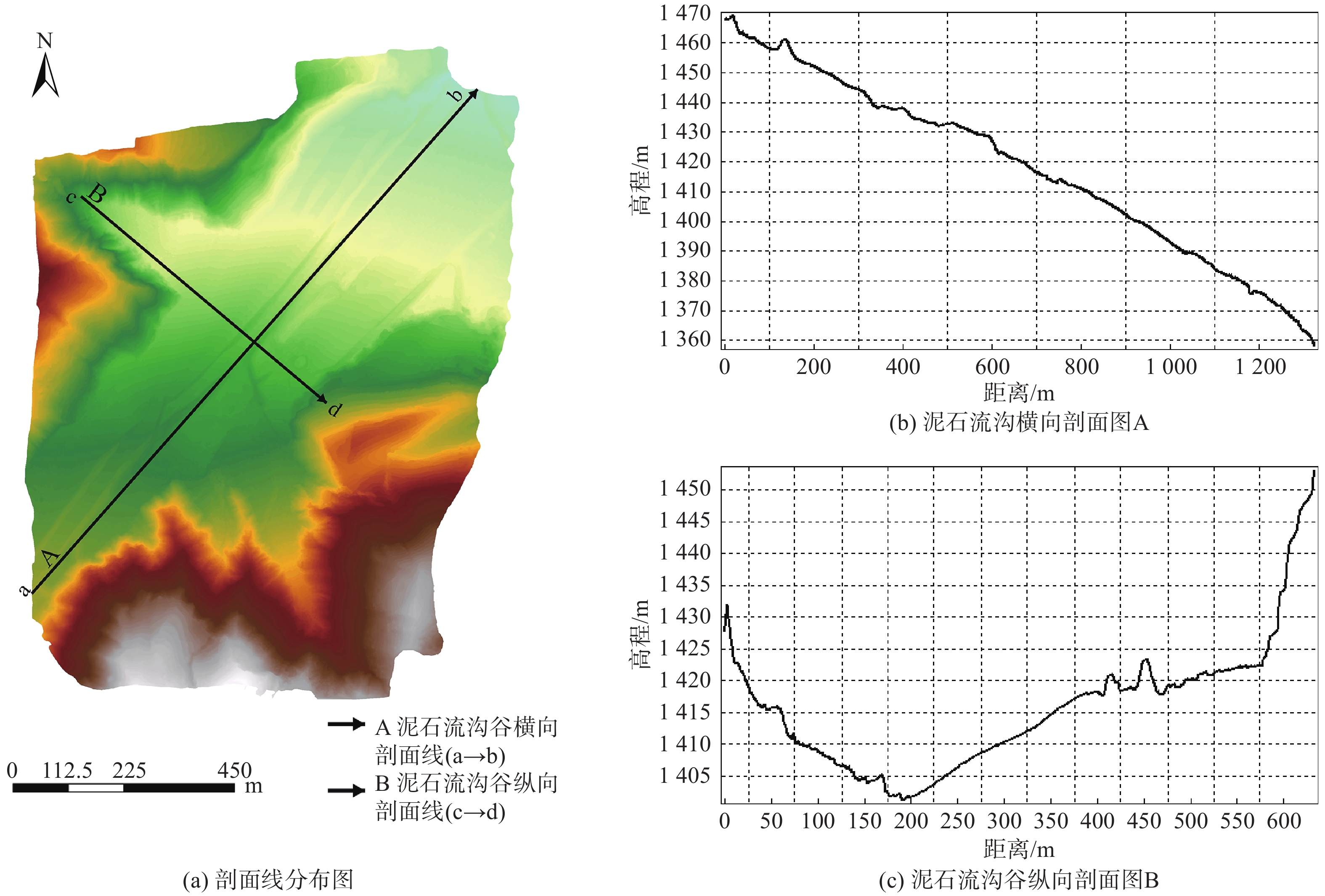
Figure 11.
Profile analysis of debris flow ditch area