
| Citation: |
XUAN Chengqiang, ZHANG Yangsong, XU Wentao. Extraction of the discontinuity orientation from a digital surface model[J]. Hydrogeology & Engineering Geology, 2022, 49(1): 75-83. doi: 10.16030/j.cnki.issn.1000-3665.202104029

|
Extraction of the discontinuity orientation from a digital surface model
-
Abstract
The traditional field contact measurement for obtaining parameters of the rock mass discontinuity is of low efficiency and big workload, and the accuracy of the results are affected by human factors. In this paper a method is presented to automatically recognize the discontinuity based on the three dimensional (3D) digital surface model (DSM) of rock mass obtained with the digital photogrammetry and structure from motion (SFM) algorithm. The steps of rock mass DSM reconstruction include collecting rock mass images, matching image features based on the Scale-Invariant Feature Transform (SIFT) algorithm, reconstructing sparse point cloud, encrypting point cloud, and reconstructing the rock mass surface model. The main flow of the discontinuity recognition method include smoothing the DSM of rock mass, changing the searching radius and the angle threshold to split model plane, searching the discontinuity based on the regional growth principle, and fitting the discontinuity based on random sampling consistency to get the orientation. The method is applied to the underground experimental roadway in the Beishan area of Gansu, and the reconstruction of 3D digital surface model of roadway and the orientation acquisition of discontinuities are realized. The discontinuities are also mapped on the roadway model by groups. A comparison the results with those of the manual field measurement method and the existing discontinuity recognition software shows that the method proposed in this paper is of good accuracy and can provide a certain reference for engineering applications.
-

-
References
[1] 徐则双. 基于近景摄影测量获取结构面信息的岩体质量评价[D]. 长春: 吉林大学, 2019. XU Zeshuang. Quality evaluation of rock mass based on close-range photogrammetry to structural plane information[D]. Changchun: Jilin University, 2019. (in Chinese with English abstract) [2] XU W T, ZHANG Y S, LI X Z, et al. Extraction and statistics of discontinuity orientation and trace length from typical fractured rock mass: a case study of the Xinchang underground research laboratory site, China[J]. Engineering Geology,2020,269:105553. doi: 10.1016/j.enggeo.2020.105553 [3] LATO M, DIEDERICHS M S, HUTCHINSON D J, et al. Optimization of LiDAR scanning and processing for automated structural evaluation of discontinuities in rockmasses[J]. International Journal of Rock Mechanics and Mining Sciences,2009,46(1):194 − 199. doi: 10.1016/j.ijrmms.2008.04.007 [4] GUO J T, LIU S J, ZHANG P N, et al. Towards semi-automatic rock mass discontinuity orientation and set analysis from 3D point clouds[J]. Computers & Geosciences,2017,103:164 − 172. [5] RIQUELME A J, ABELLÁN A, TOMÁS R. Discontinuity spacing analysis in rock masses using 3D point clouds[J]. Engineering Geology,2015,195:185 − 195. doi: 10.1016/j.enggeo.2015.06.009 [6] 黄海宁, 黄健, 周春宏, 等. 无人机影像在高陡边坡危岩体调查中的应用[J]. 水文地质工程地质,2019,46(6):149 − 155. [HUANG Haining, HUANG Jian, ZHOU Chunhong, et al. Application of UAV images to rockfall investigation at the high and steep slope[J]. Hydrogeology & Engineering Geology,2019,46(6):149 − 155. (in Chinese with English abstract) [7] 胡瀚, 王凤艳, 王明常, 等. 数字摄影测量采集岩体结构面信息的控制测量方法[J]. 世界地质,2018,37(1):309 − 315. [HU Han, WANG Fengyan, WANG Mingchang, et al. Control survey for rock discontinuity information acquisition by digital photogrammetry[J]. Global Geology,2018,37(1):309 − 315. (in Chinese with English abstract) [8] 嵇美伟, 章杨松, 李晓昭. 基于摄影测量技术的岩体结构面参数的获取[J]. 科学技术与工程,2019,19(24):344 − 351. [JI Meiwei, ZHANG Yangsong, LI Xiaozhao. Extraction of rock mass structural attitudes based on photogrammetry technology[J]. Science Technology and Engineering,2019,19(24):344 − 351. (in Chinese with English abstract) doi: 10.3969/j.issn.1671-1815.2019.24.054 [9] 陈建琴, 李晓军, 朱合华. 基于点云的岩体间距与粗糙度的自动化提取[J]. 地下空间与工程学报,2017,13(1):133 − 140. [CHEN Jianqin, LI Xiaojun, ZHU Hehua. Automatic extract of rock mass spacing and roughness based on point clouds[J]. Chinese Journal of Underground Space and Engineering,2017,13(1):133 − 140. (in Chinese with English abstract) [10] SUN Shangqu, LI Liping, QIN Chengshuai, et al. Digitizing and modeling of structural planes in fractured rock mass tunnel based on SFM[J]. Arabian Journal of Geosciences,2019,12(11):1 − 13. [11] 杨文治, 赵鹏. 基于三维激光点云数据的岩体结构面提取方法研究[J]. 勘察科学技术,2015(3):22 − 25. [YANG Wenzhi, ZHAO Peng. Research on extraction method of rock structural plane based on three-dimensional laser point cloud data[J]. Site Investigation Science and Technology,2015(3):22 − 25. (in Chinese with English abstract) doi: 10.3969/j.issn.1001-3946.2015.03.007 [12] CACCIARI P P, FUTAI M M. Mapping and characterization of rock discontinuities in a tunnel using 3D terrestrial laser scanning[J]. Bulletin of Engineering Geology and the Environment,2016,75(1):223 − 237. doi: 10.1007/s10064-015-0748-3 [13] RIQUELME A J, ABELLÁN A, TOMÁS R, et al. A new approach for semi-automatic rock mass joints recognition from 3D point clouds[J]. Computers & Geosciences,2014,68:38 − 52. [14] CHEN J Q, ZHU H H, LI X J. Automatic extraction of discontinuity orientation from rock mass surface 3D point cloud[J]. Computers & Geosciences,2016,95:18 − 31. [15] LOWE D G. Distinctive image features from scale-invariant keypoints[J]. International Journal of Computer Vision,2004,60(2):91 − 110. doi: 10.1023/B:VISI.0000029664.99615.94 [16] LOWE D G. Object recognition from local scale-invariant features[C]//Proceedings of the Seventh IEEE International Conference on Computer Vision. September 20−27, 1999, Kerkyra, Greece. IEEE, 1999: 1150−1157. [17] 韩超. 基于无人机航拍图像的三维重建SFM算法研究[D]. 呼和浩特: 内蒙古工业大学, 2019. HAN Chao. SFM algorithm of 3D reconstruction from UAV aerial images[D]. Hohhot: Inner Mongolia University of Tehchnology, 2019. (in Chinese with English abstract) [18] FURUKAWA Y, PONCE J. Carved visual hulls for image-based modeling[J]. International Journal of Computer Vision,2009,81(1):53 − 67. doi: 10.1007/s11263-008-0134-8 [19] CIGNONI P, CALLIERI M, CORSINI M, et al. MeshLab: an open-source mesh processing tool[J]. Computing,2008,1:129 − 136. [20] UMILI G, FERRERO A, EINSTEIN H H. A new method for automatic discontinuity traces sampling on rock mass 3D model[J]. Computers & Geosciences,2013,51:182 − 192. [21] FISCHLER M A, BOLLES R C. Random sample consensus: a paradigm for model fitting with applications to image analysis and automated cartography[J]. Communications of the ACM,1981,24(6):381 − 395. doi: 10.1145/358669.358692 [22] WANG J, CHEN L, SU R, et al. The Beishan underground research laboratory for geological disposal of high-level radioactive waste in China: Planning, site selection, site characterization and in situ tests[J]. Journal of Rock Mechanics and Geotechnical Engineering,2018,10(3):411 − 435. doi: 10.1016/j.jrmge.2018.03.002 [23] FISHER R. Dispersion on a sphere[J]. Proceedings of the Royal Society A:Mathematical, Physical and Engineering Sciences,1953,217(1130):295 − 305. doi: 10.1098/rspa.1953.0064 -
Access History

Figures(12)
Tables(3)

Export File
Citation
XUAN Chengqiang, ZHANG Yangsong, XU Wentao. Extraction of the discontinuity orientation from a digital surface model[J]. Hydrogeology & Engineering Geology, 2022, 49(1): 75-83. doi: 10.16030/j.cnki.issn.1000-3665.202104029
Format
Content
 DownLoad:


-
Figure 1.
SIFT feature point vectors
-
Figure 2.
3D reconstruction model of roadway
-
Figure 3.
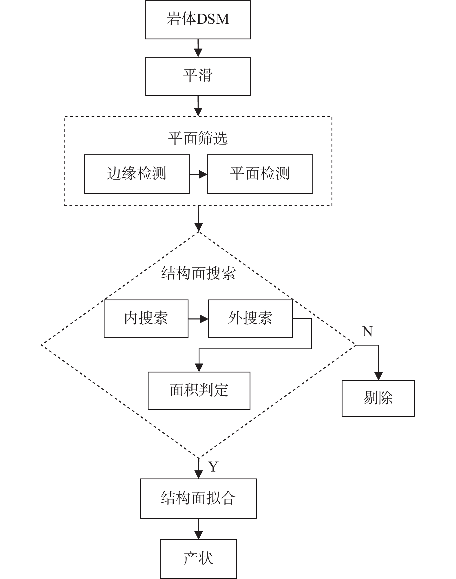
Flow chart of discontinuities recognition
-
Figure 4.
Smoothing rock mass DSM
-
Figure 5.
Processes of discontinuities recognition
-
Figure 6.
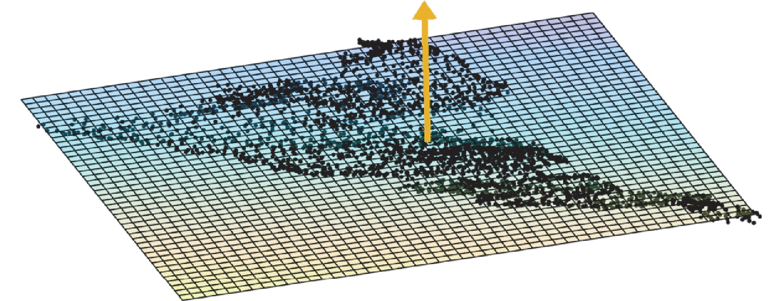
Fitting a plane to the point cloud of a discontinuity by RANSAC
-
Figure 7.
Relationship between normal vector and orientation
-
Figure 8.
Segmenting discontinuities point cloud using DSE
-
Figure 9.
Field measurement work photo in the Beishan exploration tunnel
-
Figure 10.
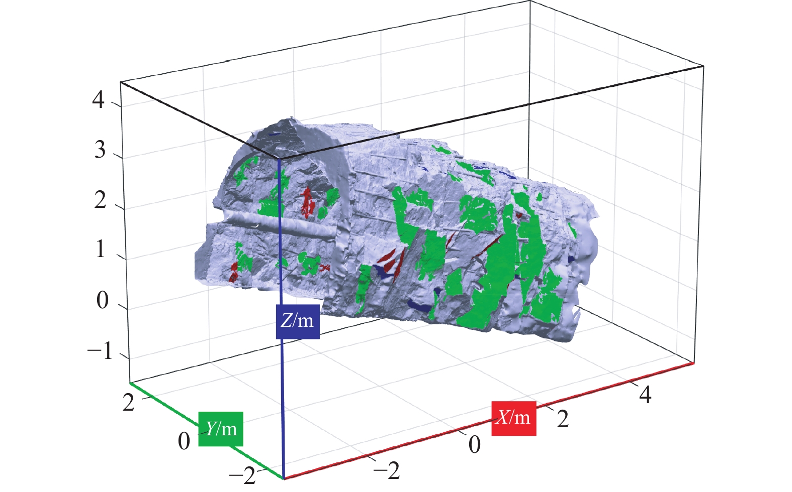
Roadway surrounding rock discontinuities recognition result
-
Figure 11.
Pole distribution of discontinuities orientation cluster grouping
-
Figure 12.
Roadway surrounding rock discontinuities mapped by groups