
| Citation: |
HAN Xudong, FU Jie, LI Yanyan, WANG Gaofeng, CAO Chen. A study of the early identification and risk assessment of the Jiangdingya landslide in Zhouqu county[J]. Hydrogeology & Engineering Geology, 2021, 48(6): 180-186. doi: 10.16030/j.cnki.issn.1000-3665.202104028

|
A study of the early identification and risk assessment of the Jiangdingya landslide in Zhouqu county
-
Abstract
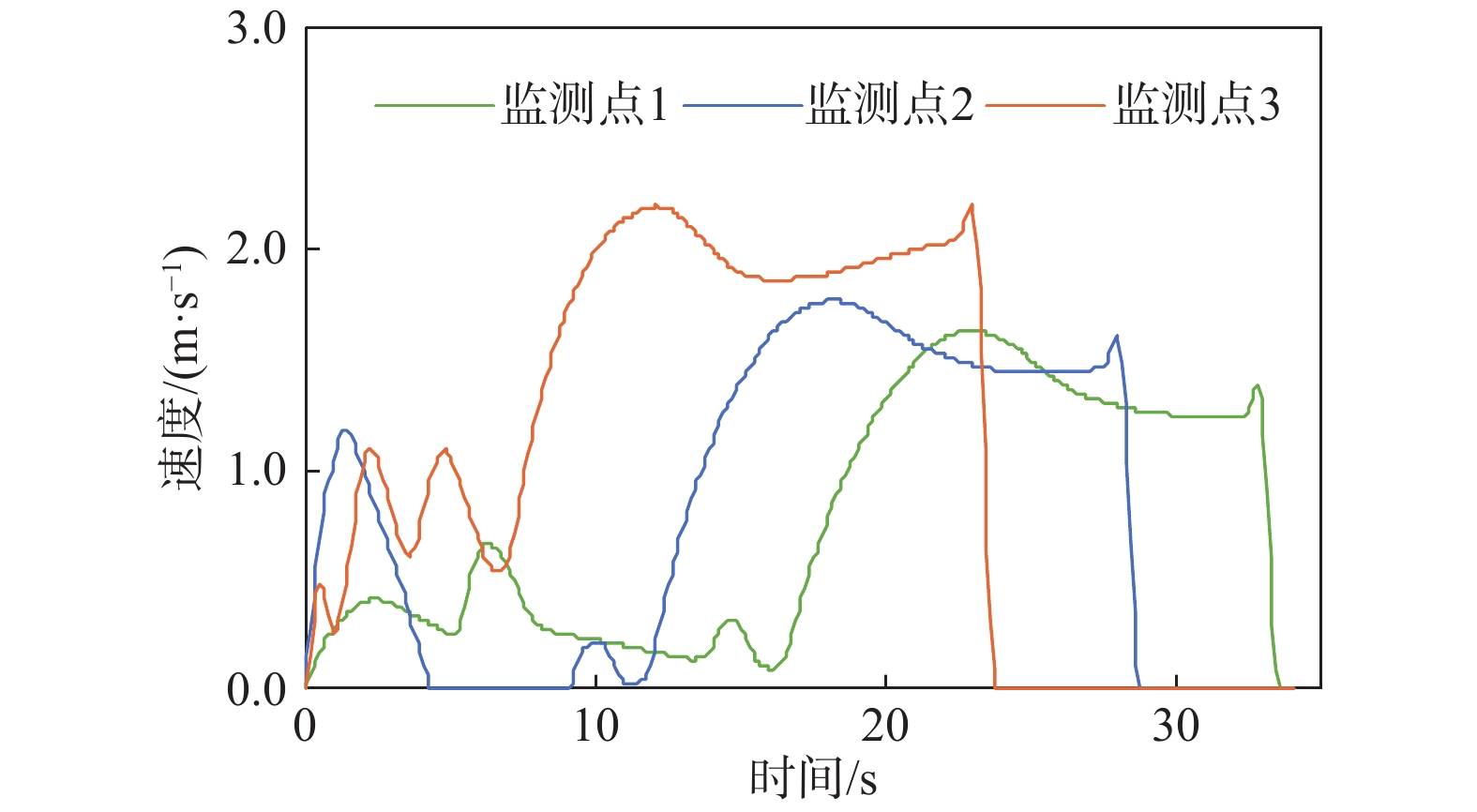
How to identify deformed landslides in advance and conduct early risk assessments on them has become a research hotspot in the field of geological disaster prevention and control. In response to the above problems, the Jiangdingya landslide in the Bailong River Basin in Zhouqu is taken as a back analysis case, and a comprehensive study of the early identification and risk assessment of the landslide is carried out. In this paper, a full-process analysis method is proposed, which combine the small baseline subset interferometric synthetic aperture radar (SBAS-InSAR) technology interpretation, geo-mechanical analysis and dynamic process simulation. The research results show that the SABS-InSAR technology interpretation can effectively identify the range of the Jiangdingya landslide and its early deformation. It may be preliminarily determined that the failure mode of the Jiangdingya landslide is trailed and the plane characteristics of the landslide body is generally about 680 m in length and 210 m in width. Based on the early identification information and through geo-mechanical analysis, it is finally identified that the instability problem of the Jiangdingya landslide is a typical deformation problem of the front edge of the old accumulation layer landslide. The failure mode is the traction slip failure, the average thickness of the landslide body is in about 35 m, the overall slope of the sliding bed is relatively slow, and the moving speed is not large after instability. On the basis of the above analyses, a Coulomb friction model that conformed to the sliding friction characteristics of the Jiangdingya landslide body is selected. Based on the depth integral continuum equation, the dynamic process of the Jiangdingya landslide body is calculated and the speed of the landslide body is monitored. In terms of velocity monitoring curves and accumulation pattern, the sliding velocity of the landslide body is not large, the maximum value is about 2.2 m/s, the overall performance is pushing the Bailong River channel, and the possibility of blocking the river is relatively small. In addition, when the displacement of the front edge of the Jiangdingya landslide body is completed, the speed of the landslide body from the front edge to the rear edge quickly drope to zero, and the movement process is characterized by the traction movement. The analysis results of the Jiangdingya landslide in this paper are consistent with the actual event of the Jiangdingya landslide. The comprehensive analysis method and research model can provide a good reference for the early identification and risk assessment of similar landslides in the Bailong River Basin in Zhouqu county.
-

-
References
[1] COSTANTINI M, FERRETTI A, MINATI F, et al. Analysis of surface deformations over the whole Italian territory by interferometric processing of ERS, Envisat and COSMO-SkyMed radar data[J]. Remote Sensing of Environment,2017,202:250 − 275. doi: 10.1016/j.rse.2017.07.017 [2] DONG J, ZHANG L, LI M H, et al. Measuring precursory movements of the recent Xinmo landslide in Mao County, China with Sentinel-1 and ALOS-2 PALSAR-2 datasets[J]. Landslides,2018,15(1):135 − 144. doi: 10.1007/s10346-017-0914-8 [3] 陆会燕, 李为乐, 许强, 等. 光学遥感与InSAR结合的金沙江白格滑坡上下游滑坡隐患早期识别[J]. 武汉大学学报(信息科学版),2019,44(9):1342 − 1354. [LU Huiyan, LI Weile, XU Qiang, et al. Early detection of landslides in the upstream and downstream areas of the Baige landslide, the Jinsha river based on optical remote sensing and InSAR technologies[J]. Geomatics and Information Science of Wuhan University,2019,44(9):1342 − 1354. (in Chinese with English abstract) [4] 许强, 董秀军, 李为乐. 基于天-空-地一体化的重大地质灾害隐患早期识别与监测预警[J]. 武汉大学学报(信息科学版),2019,44(7):957 − 966. [XU Qiang, DONG Xiujun, LI Weile. Integrated space-air-ground early detection, monitoring and warning system for potential catastrophic geohazards[J]. Geomatics and Information Science of Wuhan University,2019,44(7):957 − 966. (in Chinese with English abstract) [5] 李世海, 刘天苹, 刘晓宇. 论滑坡稳定性分析方法[J]. 岩石力学与工程学报,2009,28(增刊2):3309 − 3324. [LI Shihai, LIU Tianping, LIU Xiaoyu. Analysis method for landslide stability[J]. Chinese Journal of Rock Mechanics and Engineering,2009,28(Sup2):3309 − 3324. (in Chinese with English abstract) [6] 饶鸿, 王金淑, 赵志明, 等. 基于有限元软件自定义本构模型的膨胀土边坡降雨入渗分析[J]. 水文地质工程地质,2021,48(1):154 − 162. [RAO Hong, WANG Jinshu, ZHAO Zhiming, et al. An analysis of rainfall infiltration of expansive soil slope based on the finite element software custom constitutive model[J]. Hydrogeology & Engineering Geology,2021,48(1):154 − 162. (in Chinese with English abstract) [7] 殷跃平, 王文沛. 高位远程滑坡动力侵蚀犁切计算模型研究[J]. 岩石力学与工程学报,2020,39(8):1513 − 1521. [YIN Yueping, WANG Wenpei. A dynamic erosion plowing model of long Run-out landslides initialized at high locations[J]. Chinese Journal of Rock Mechanics and Engineering,2020,39(8):1513 − 1521. (in Chinese with English abstract) [8] HAN X D, CHEN J P, XU P H, et al. A well-balanced numerical scheme for debris flow Run-out prediction in Xiaojia Gully considering different hydrological designs[J]. Landslides,2017,14(6):2105 − 2114. doi: 10.1007/s10346-017-0850-7 [9] 刘广煜, 徐文杰, 佟彬, 等. 基于块体离散元的高速远程滑坡灾害动力学研究[J]. 岩石力学与工程学报,2019,38(8):1557 − 1566. [LIU Guangyu, XU Wenjie, TONG Bin, et al. Study on dynamics of high-speed and long Run-out landslide hazards based on block discrete element method[J]. Chinese Journal of Rock Mechanics and Engineering,2019,38(8):1557 − 1566. (in Chinese with English abstract) [10] 张卫雄, 翟向华, 丁保艳, 等. 甘肃舟曲江顶崖滑坡成因分析与综合治理措施[J]. 中国地质灾害与防治学报,2020,31(5):7 − 14. [ZHANG Weixiong, ZHAI Xianghua, DING Baoyan, et al. Causative analysis and comprehensive treatment of the jiangdingya landslide in Zhouqu County of Gansu Province[J]. The Chinese Journal of Geological Hazard and Control,2020,31(5):7 − 14. (in Chinese with English abstract) [11] BERARDINO P, FORNARO G, LANARI R, et al. A new algorithm for surface deformation monitoring based on small baseline differential SAR interferograms[J]. IEEE Transactions on Geoscience and Remote Sensing,2002,40(11):2375 − 2383. doi: 10.1109/TGRS.2002.803792 [12] 许才军, 何平, 温扬茂, 等. InSAR技术及应用研究进展[J]. 测绘地理信息,2015,40(2):1 − 9. [XU Caijun, HE Ping, WEN Yangmao, et al. Recent advances InSAR interferometry and its applications[J]. Journal of Geomatics,2015,40(2):1 − 9. (in Chinese with English abstract) [13] CHEN D H, CHEN H E, ZHANG W, et al. Characteristics of the residual surface deformation of multiple abandoned mined-out areas based on a field investigation and SBAS-InSAR: a case study in Jilin, China[J]. Remote Sensing,2020,12(22):3752. doi: 10.3390/rs12223752 [14] 亓星, 朱星, 许强, 等. 基于斋藤模型的滑坡临滑时间预报方法改进及应用[J]. 工程地质学报,2020,28(4):832 − 839. [QI Xing, ZHU Xing, XU Qiang, et al. Improvement and application of landslide proximity time prediction method based on saito model[J]. Journal of Engineering Geology,2020,28(4):832 − 839. (in Chinese with English abstract) [15] 钟昌茂, 邱恩喜, 魏永幸, 等. 基于桩体抗剪强度的复合地基路堤稳定性分析方法[J]. 水文地质工程地质,2020,47(5):100 − 107. [ZHONG Changmao, QIU Enxi, WEI Yongxing, et al. Stability analysis method for the composite foundation embankment based on pile shear strength[J]. Hydrogeology & Engineering Geology,2020,47(5):100 − 107. (in Chinese with English abstract) [16] 王开喜, 张鹏. 舟曲白龙江城区段防洪堤设计水力学计算[J]. 甘肃水利水电技术,2010,46(12):41 − 43. [WANG Kaixi, ZHANG Peng. Hydraulic calculation of flood protection embankment design in city section of Bailong river in Zhouqu[J]. Gansu Water Conservancy and Hydropower Technology,2010,46(12):41 − 43. (in Chinese with English abstract) [17] AN H, KIM M, LEE G, et al. Estimation of the area of sediment deposition by debris flow using a physical-based modeling approach[J]. Quaternary International,2019,503:59 − 69. doi: 10.1016/j.quaint.2018.09.049 [18] HUNGR O. Simplified models of spreading flow of dry granular material[J]. Canadian Geotechnical Journal,2008,45(8):1156 − 1168. doi: 10.1139/T08-059 -
Access History
Figures(9)
Tables(2)

Export File
Citation
HAN Xudong, FU Jie, LI Yanyan, WANG Gaofeng, CAO Chen. A study of the early identification and risk assessment of the Jiangdingya landslide in Zhouqu county[J]. Hydrogeology & Engineering Geology, 2021, 48(6): 180-186. doi: 10.16030/j.cnki.issn.1000-3665.202104028
Format
Content
 DownLoad:

-
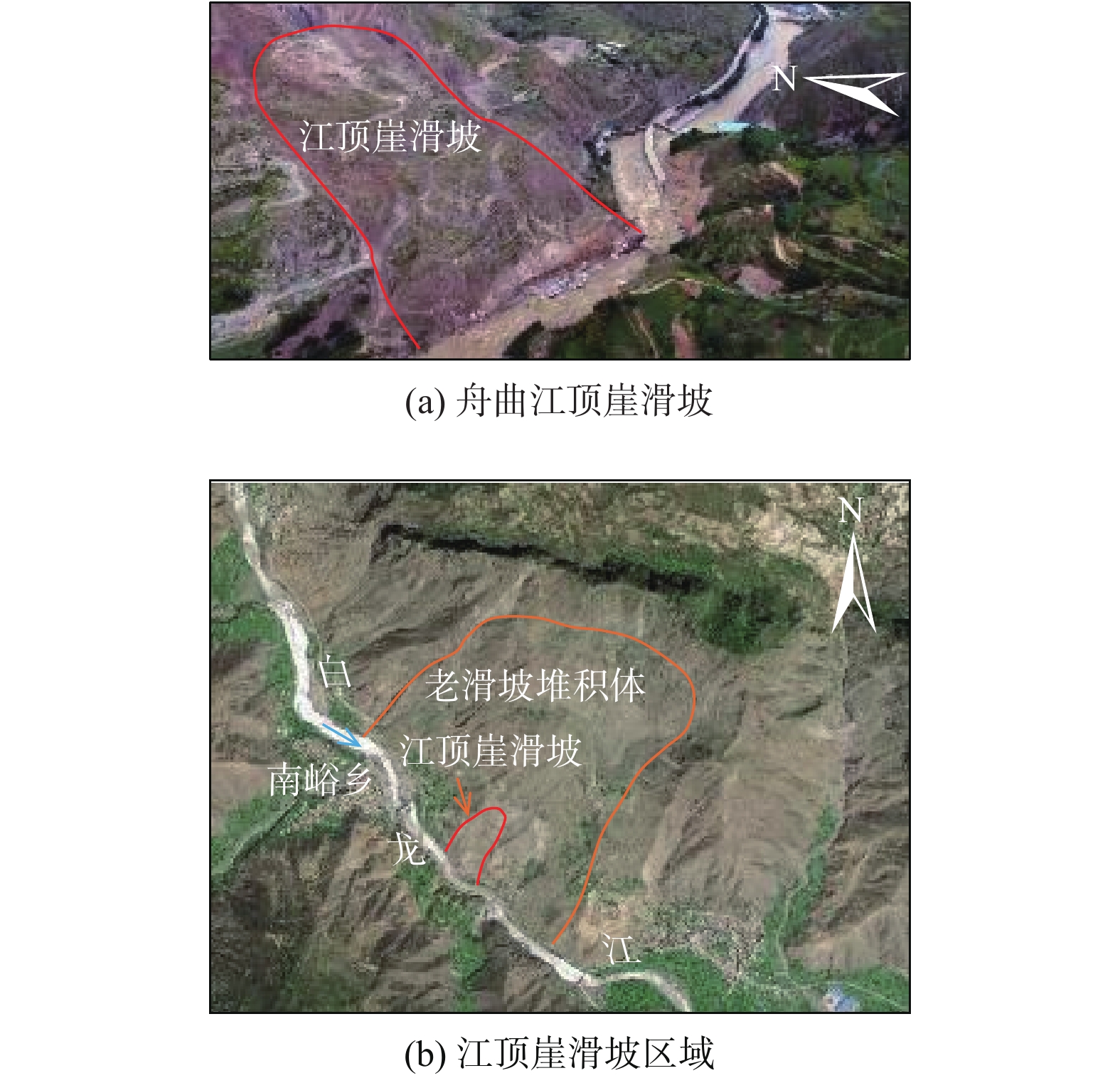
Figure 1.
Jiangdingya ladslide and remote sensing image in the Jiangdingya landslide area in Zhouqu
-
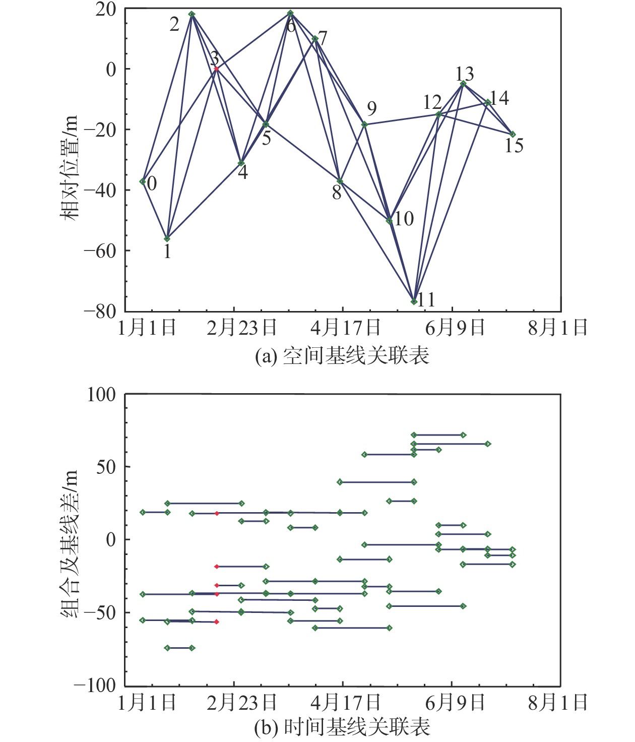
Figure 2.
Association of spatial and temporal baselines of 16 periods of sentinel-1A SAR data
-
Figure 3.
Interference phase distribution of SAR images in the Jiangdingya landslide area
-
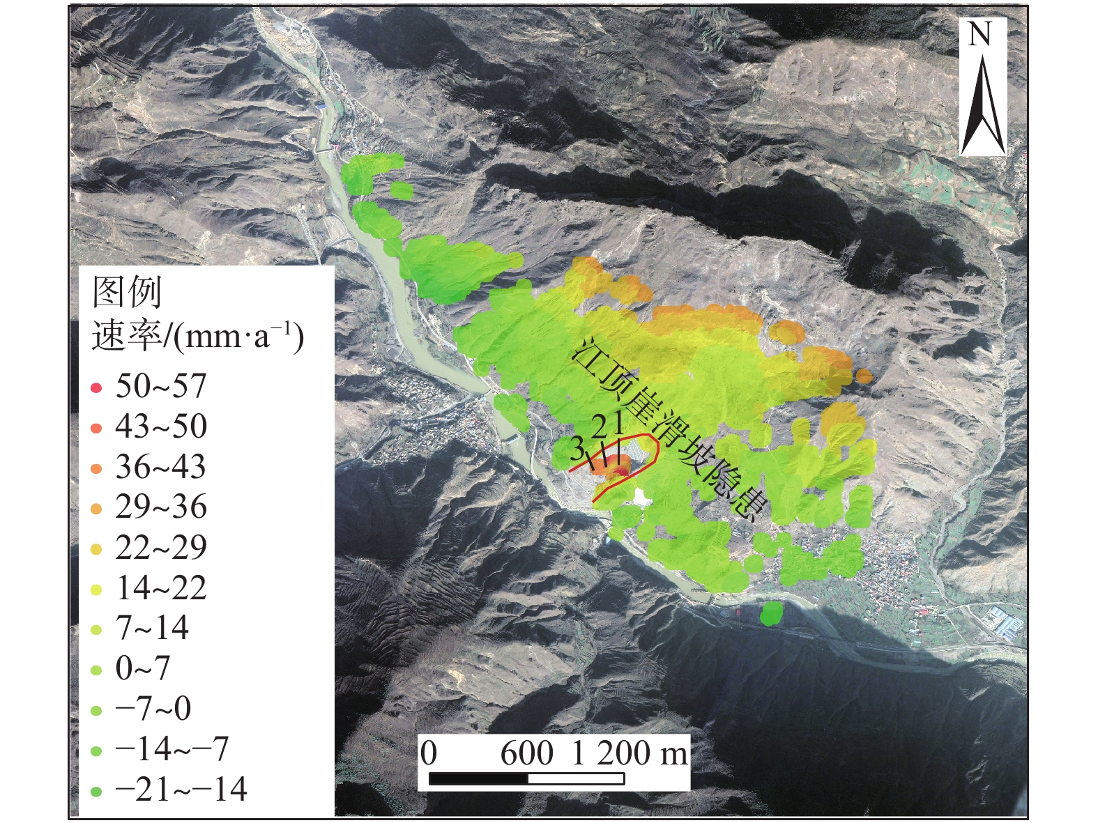
Figure 4.
Average surface deformation rate in the Jiangdingya landslide area
-
Figure 5.
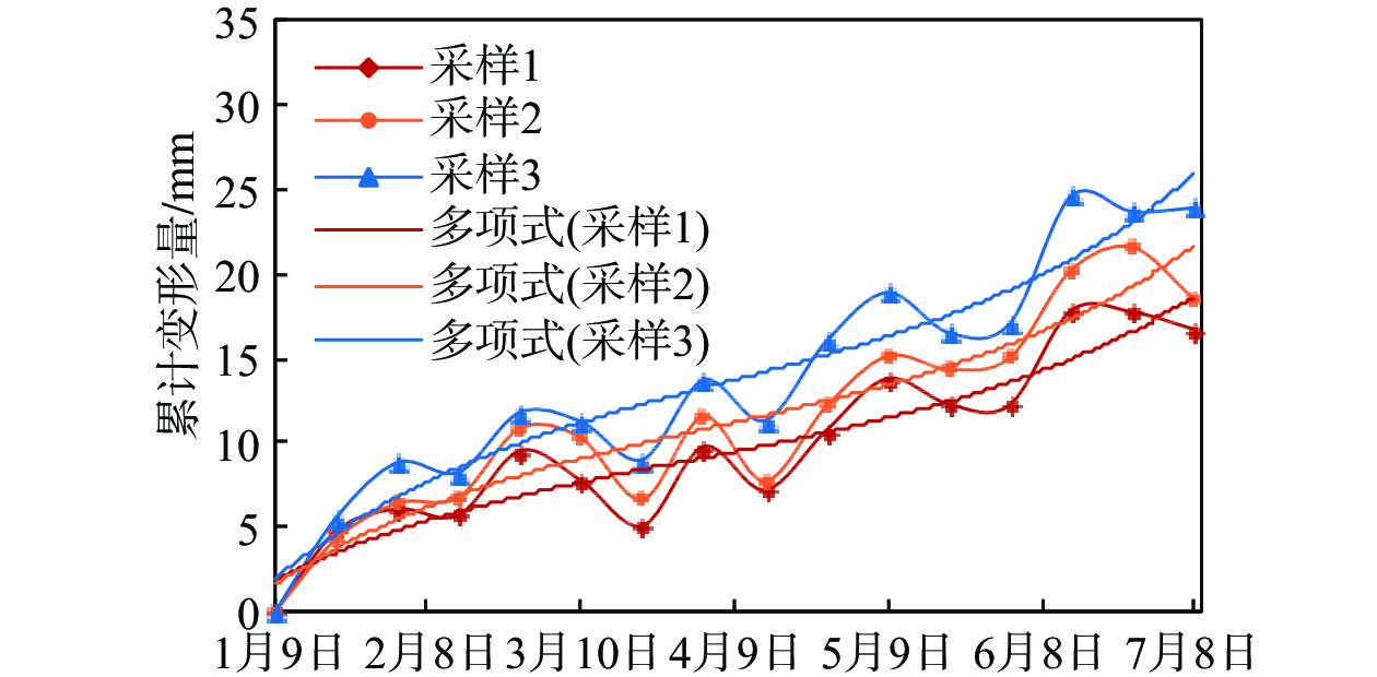
Cumulative deformation curves of the Jiangdingya landslide in radar line of sight
-
Figure 6.
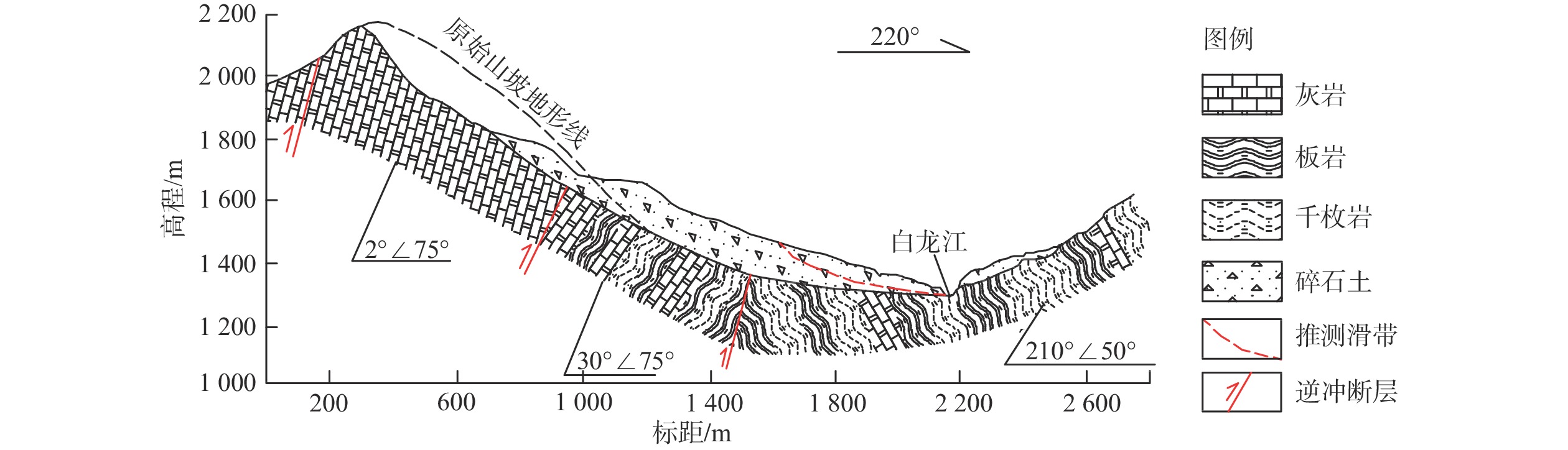
Geological profile of the Jiangdingya landslide
-
Figure 7.
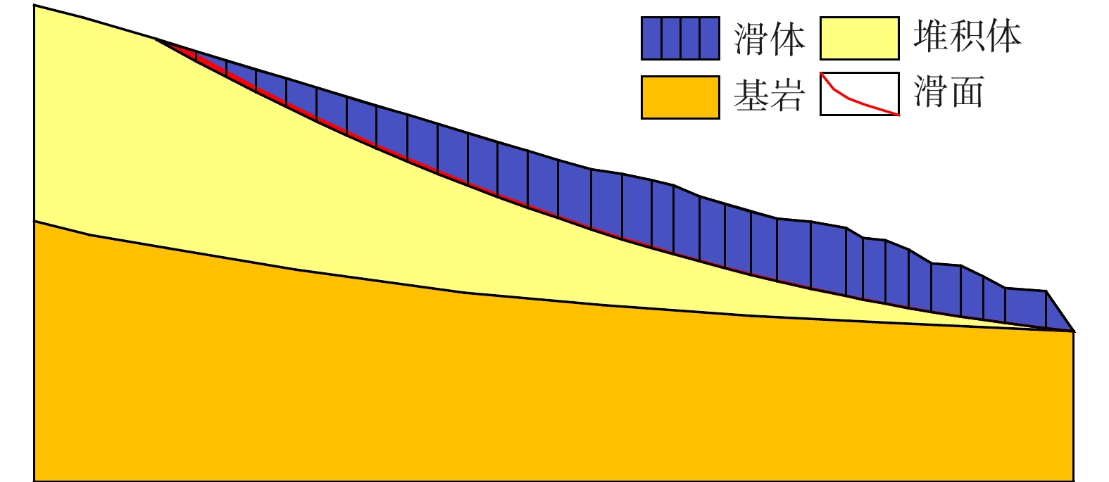
Stability calculation model for the Jiangdingya landslide
-
Figure 8.
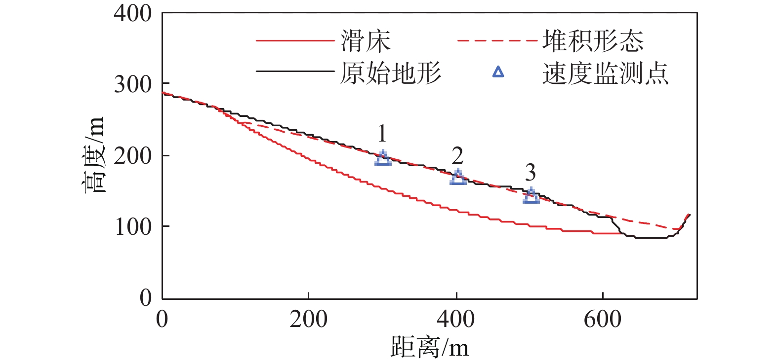
Post-sliding geometry of the Jiangdingya landslide body
-
Figure 9.
Velocity monitoring curve of the Jiangdingya landslide body