
| Qingdao Institute of marine geology, China Geological Survey | Host |
| Citation: |
MA Yuanhao, GU Peng, ZHOU Chunyan, WANG Qiushun. Analysis of spatiotemporal changes of coastline and coastal zone in Sanmen Bay, Zhejiang Province in recent 40 years based on remote sensing[J]. Marine Geology Frontiers, 2024, 40(4): 60-70. doi: 10.16028/j.1009-2722.2023.070

|
Analysis of spatiotemporal changes of coastline and coastal zone in Sanmen Bay, Zhejiang Province in recent 40 years based on remote sensing
-
Abstract
The coastline of Sanmen Bay in Zhejiang Province, East China was classified as rocky coastline, sandy coastline, muddy coastline, artificial coastline, and estuary coastline by human-computer interaction based on the Landsat satellite images of 1985, 1995, 2005, 2013, and 2020. The landuse types in the coastal zone of Sanmen Bay were classified as water bodies, forest, bare land, urban, and agriculture using interactive supervision. The results represent that rocky coastline and artificial coastline in the bay have been changed significantly in the past 40 years. Most prominently, the artificial coastline was increased by 80.3 km while the rocky coastline decreased by 79.3 km. The urban and water bodies were the major landuse of recently reclaimed area, which has extended the coastal zone of Sanmen Bay by 130 km2 in accumulation in the last 40 years. The conversions from bare land to urban, bare land to agricultural, and forest to urban are the primary land transfer types in the Sanmen Bay coastal zone. In the past 40 years, the fractal dimension of Sanmen Bay coastline has been decreased from 1.22 to 1.201, and the proportion of artificial coastline and urban has been increased by 13% and 22.57% respectively, in general trends of seaward advancement and rising artificiality/urbanization. Human activities are primarily responsible for the changes in the coastline and coastal zone land use of Sanmen Bay. With the implementation of protection and rational use of the coastal zone, the development and exploitation of the Sanmen Bay coastal zone has been gradually improving and stabilizing.
-

-
References
[1] 丁晟平,崔胜辉,徐礼来,等. 1957—2019年厦门市马銮湾海岸线和围填海时空演变及互动关系分析[J]. 应用海洋学学报,2021,40(2):260-270. [2] 张翔,王霄鹏,黄安齐,等. 基于遥感影像提取山东半岛复杂海岸线及海岸线多年变迁研究[J]. 海洋湖沼通报,2021,43(2):171-181. [3] ABDULLAH A M,MASRUR A,ADNAN M S G,et al. Spatio-temporal patterns of land use/land cover change in the heterogeneous coastal region of Bangladesh between 1990 and 2017[J]. Remote Sensing,2019,11(7):790. doi: 10.3390/rs11070790 [4] HUSSEIN K,ALKAABI K,GHEBREYESUS D,et al. Land use/land cover change along the eastern coast of the UAE and its impact on flooding risk[J]. Geomatics, Natural Hazards and Risk,2020,11(1):112-130. doi: 10.1080/19475705.2019.1707718 [5] KAYA I A,GORGUN E K. Land use and land cover change monitoring in Bandirma (Turkey) using remote sensing and geographic information systems[J]. Environmental Monitoring and Assessment,2020,192(7):430. doi: 10.1007/s10661-020-08411-1 [6] 范剑超,姜大伟,赵建华,等. GF-3号SAR卫星遥感围填海监测方法研究:以大连金州湾为例[J]. 海洋科学,2017,41(12):60-65. [7] 张华玉,秦年秀,汪军能,等. 广西海岸带土地利用时空格局及其驱动因子[J]. 水土保持研究,2022,29(3):367-374. [8] 刘永超,李加林,王新新,等. 浙江三门湾湿地遥感时间序列演变分析[J]. 自然资源学报,2022,37(4):1036-1048. [9] 刘晓凤,段晓勇,田元,等. 三门湾水体营养盐变化及其对人类活动的响应[J]. 海洋地质前沿,2021,37(5):46-56. [10] LIU L,ZHANG X J,CHEN Z Q,et al. Assessment of ecological sustainability for international bays in the context of common prosperity:a case study of Sanmen Bay in Zhejiang Province[J]. Frontiers in Environmental Science,2022,10:863. [11] CHEN X Y,ZHANG J,MA Y,et al. Monitoring and analysis of coastline changes of the Sanmen Bay with remote sensing during the past 40 years[J]. Marine Sciences,2015,39(2):43-49. [12] 徐涵秋. 利用改进的归一化差异水体指数(MNDWI)提取水体信息的研究[J]. 遥感学报,2005,9(5):589-595. [13] HU R R,YAO L J,YU J,et al. Remote sensing of the coastline variation of the Guangdong-Hongkong-Macao Greater Bay Area in the past four decades[J]. Journal of Marine Science and Engineering,2021,9(12):1318. doi: 10.3390/jmse9121318 [14] MANDELBROT B. How long is the coast of Britain? Statistical self-similarity and fractional dimension[J]. Science (New York,NY),1967,156(3775):636-638. [15] 朱晓华,蔡运龙. 中国海岸线分维及其性质研究[J]. 海洋科学进展,2004,22(2):156-162. [16] 林明祥,蔡廷禄,王欣凯,等. 近百年来浙江三门湾海岸线时空演变特征[J]. 海洋学研究,2021,39(1):47-55. [17] WANG X,LIU Y L,LING F,et al. Spatio-temporal change detection of Ningbo coastline using landsat time-series images during 1976-2015[J]. ISPRS International Journal of Geo-Information,2017,6(3):68. doi: 10.3390/ijgi6030068 [18] 夏小明,谢钦春. 浙江三门湾海岸发育与持续利用[J]. 海洋通报,1996,15(4):49-57. [19] YU Z N,WU C F,TAN Y Z,et al. The dilemma of land expansion and governance in rural China:a comparative study based on three townships in Zhejiang Province[J]. Land Use Policy,2018,71:602-611. doi: 10.1016/j.landusepol.2017.09.054 -
Access History

Figures(8)
Tables(4)

Export File
Citation
MA Yuanhao, GU Peng, ZHOU Chunyan, WANG Qiushun. Analysis of spatiotemporal changes of coastline and coastal zone in Sanmen Bay, Zhejiang Province in recent 40 years based on remote sensing[J]. Marine Geology Frontiers, 2024, 40(4): 60-70. doi: 10.16028/j.1009-2722.2023.070
Format
Content
 DownLoad:

-
Figure 1.
Example of coastline interpretation
-
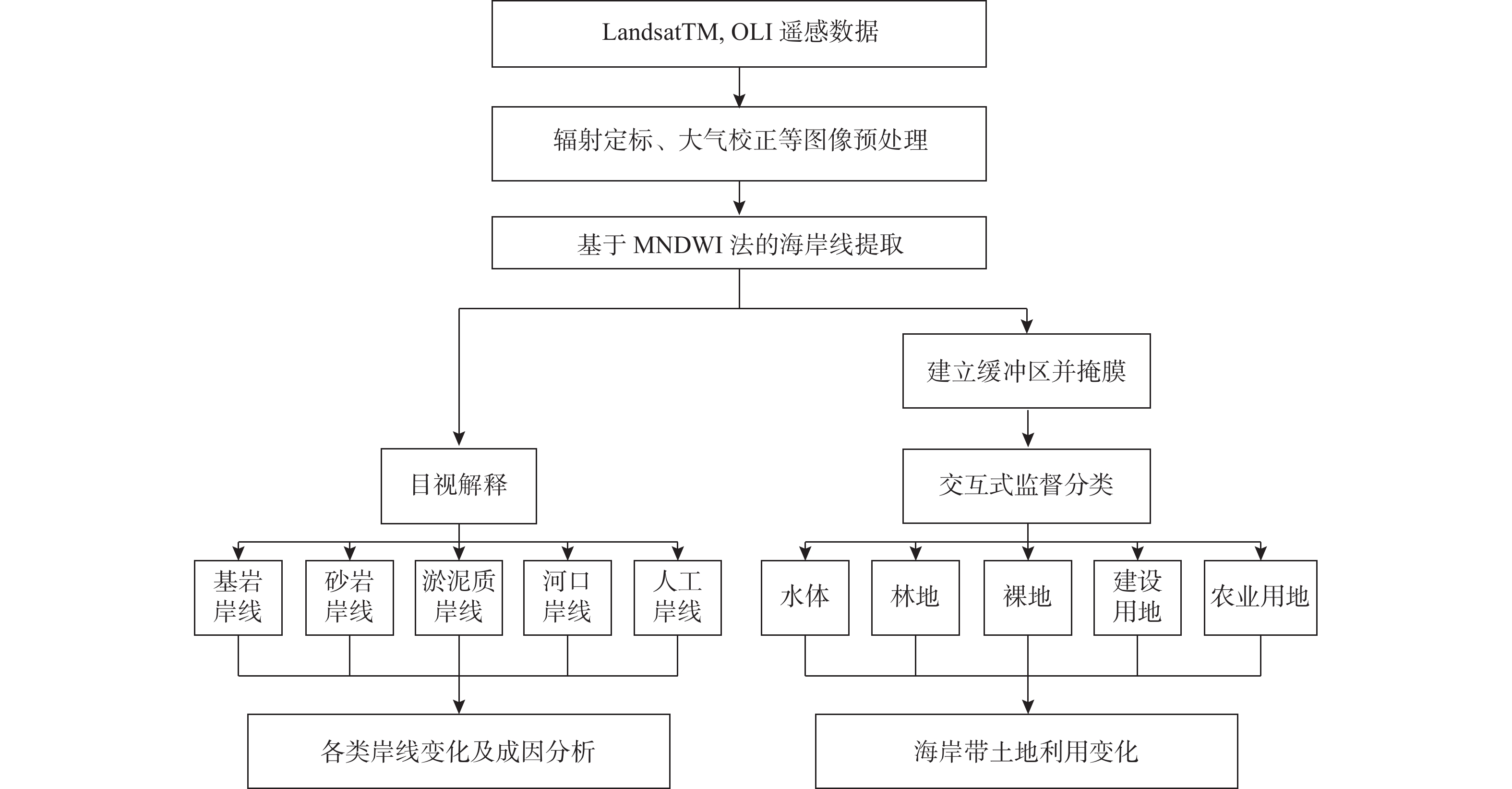
Figure 2.
Technology route of coastline extraction and landuse change detection
-
Figure 3.
Accuracy verification map of coastline extraction and landuse classification
-
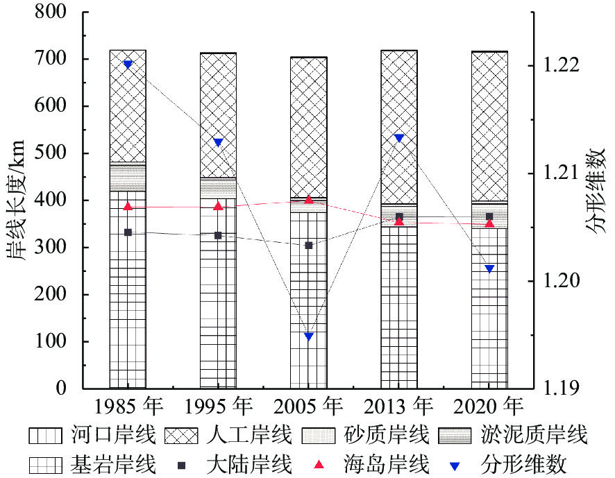
Figure 4.
Coastline length in the Sanmen Bay at different periods
-
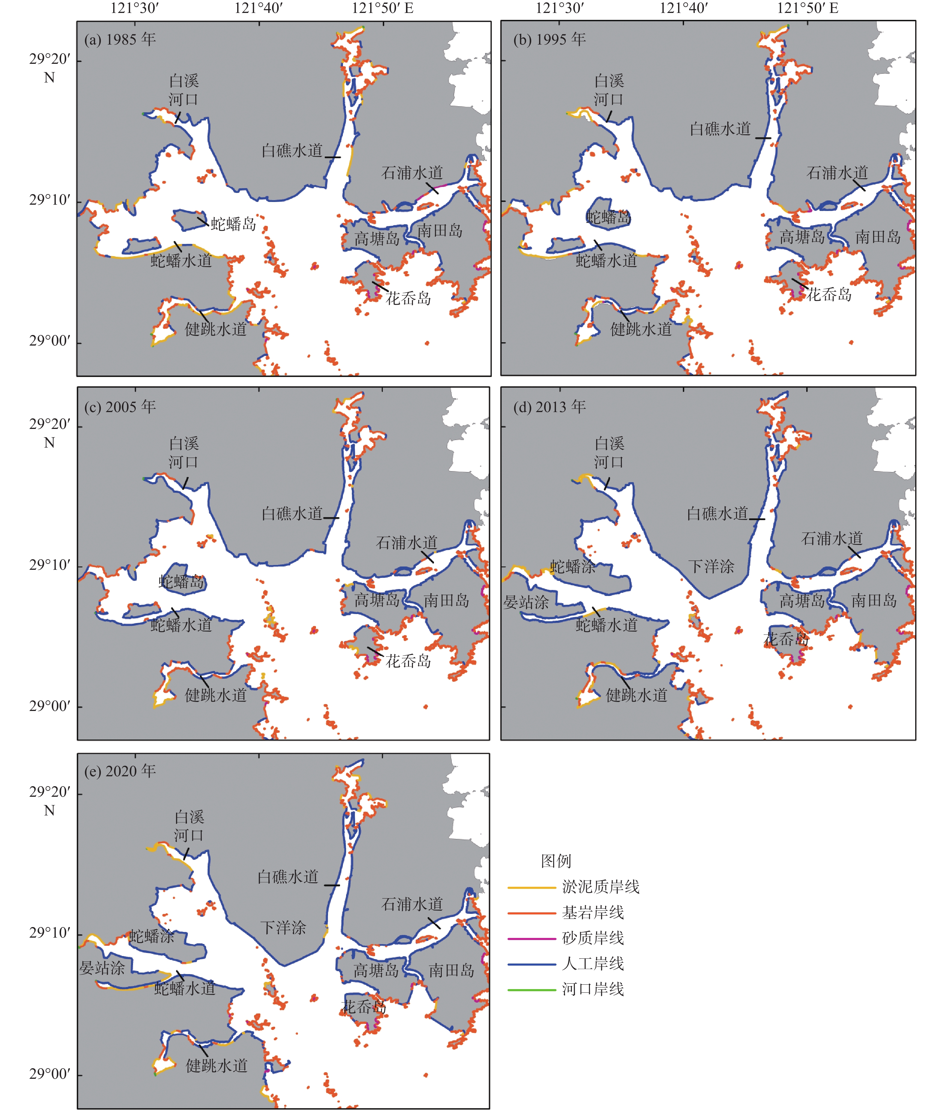
Figure 5.
Distribution of different types of coastlines in the Sanmen Bay during 1985 to 2020
-
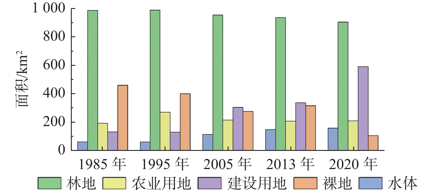
Figure 6.
Changes in landuse area in Sanmen Bay from 1980 to 2020
-
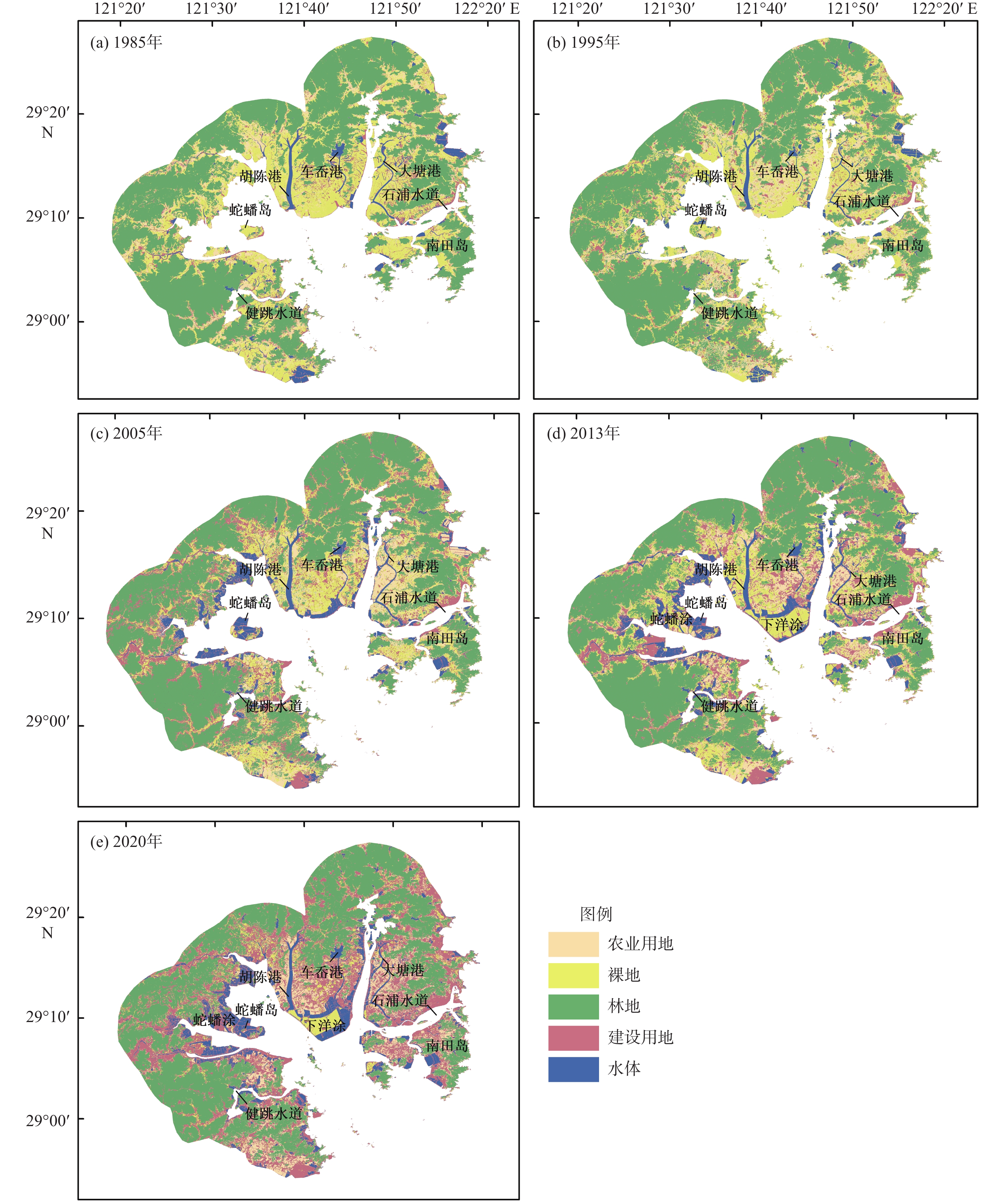
Figure 7.
The landuse mappings of the coastal zone of Sanmen Bay in different characteristic years from 1985 to 2020
-
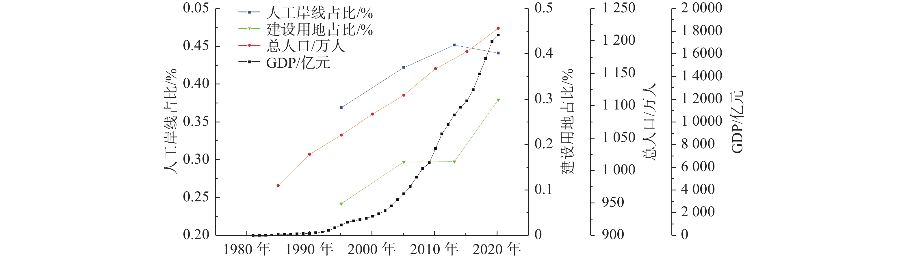
Figure 8.
Comparison of main economic and social indicators with coastline artificial and urbanization in Sanmen Bay