
| Qingdao Institute of marine geology, China Geological Survey | Host |

| Citation: |
HUANG Zhe, LIU Qiang, NI Wanzhou, XU Haijue, BAI Yuchuan. Impacts of Binhai Port construction on offshore water and sediment transportation along the abandoned Yellow River mouth[J]. Marine Geology Frontiers, 2023, 39(12): 43-55. doi: 10.16028/j.1009-2722.2022.229

|
Impacts of Binhai Port construction on offshore water and sediment transportation along the abandoned Yellow River mouth
-
Abstract
Taking the Binhai Port in the old Yellow River Delta as the background, a two-dimensional hydro-sediment model was established to simulate the changes in hydrodynamics and sediment transport due to the port construction. Results indicate the changes of tidal current velocity after the breakwater completion was from −0.8 to 0.5 m/s and concentrated mainly within 15 m isobath near breakwater construction area. The flow velocity at the head of the north breakwater increased significantly. The port area was featured with flow velocity reduction for as much as 0.6 m/s except for the ebb stage of spring tide. The port construction weakened the tidal irregularity as average amplitude of main tidal components was reduced by about 10%. The impact of the port construction on the offshore geomorphic evolution was concentrated within 8 km around the port and within the 16 m isobath areas. The head of the north breakwater was severely eroded, while sediment siltation was distributed mostly at the harbor entrance.
-

-
References
[1] BANNA M M E,FRIHY O E. Human-induced changes in the geomorphology of the northeastern coast of the Nile Delta,Egypt[J]. Geomorphology,2009,107(1/2):72-78. [2] 高善明. 全新世滦河三角洲相和沉积模式[J]. 地理学报,1981,36(3):303-314. doi: 10.3321/j.issn:0375-5444.1981.03.006 [3] FRAZIER D E. Recent deltaic deposits of the Mississippi River:their development and chronology[J]. Gulf Coast Association of Geological Societies Transactions,1967,17(2):205-230. [4] MIKHAILOV V N,MIKHAILOVA M V. Delta formation processes at the Mississippi River mouth[J]. Water Resources,2010,37(5):515-530. [5] PENLAND S,SUTER J R,BOYD R. Barrier island arcs along abandoned Mississippi River deltas[J]. Marine Geology,1985,63(1/4):197-233. [6] FRIHY O E,KOMAR P D. Patterns of beach-sand sorting and shoreline erosion on the Nile Delta[J]. Journal of Sedimentary Research,1991,61(4):544-550. [7] SMITH S E,ABDEL-KADER A. Coastal erosion along the Egyptian delta[J]. Journal of Coastal Research,1988,4(2):245-255. [8] 李从先,陈刚,王利. 滦河废弃三角洲和砂坝:泻湖沉积体系[J]. 沉积学报,1983,1(2):60-72. doi: 10.14027/j.cnki.cjxb.1983.02.005 [9] 刘益旭,朱力康,王连和. 滦河废弃三角洲瀉湖沙坝海岸演变与海港建设[J]. 海洋学报,1994,16(5):60-67. [10] 张忍顺. 苏北黄河三角洲及滨海平原的成陆过程[J]. 地理学报,1984,39(2):173-184. doi: 10.3321/j.issn:0375-5444.1984.02.005 [11] 叶青超. 试论苏北废黄河三角洲的发育[J]. 地理学报,1986,41:112-122. doi: 10.3321/j.issn:0375-5444.1986.02.002 [12] 李元芳. 废黄河三角洲的演变[J]. 地理研究,1991,10(4):29-39. [13] 任于灿,周永青. 废弃的黄河三角洲的地貌特征及演化[J]. 海洋地质与第四纪地质,1994,14(2):19-28. doi: 10.16562/j.cnki.0256-1492.1994.02.002 [14] 陈斌,周良勇,刘健,等. 废黄河口海域潮流动力与悬沙输运特征[J]. 海洋科学,2011,35(5):73-81. [15] 胡进. 废黄河三角洲海岸演变过程与悬浮泥沙研究 [D]. 上海: 华东师范大学, 2014. [16] 张长宽,陈君,林康,等. 江苏沿海滩涂围垦空间布局研究[J]. 河海大学学报(自然科学版),2011,39(2):206-212. doi: 10.3876/j.issn.1000-1980.2011.02.017 [17] 王芳,朱跃华. 江苏省沿海滩涂资源开发模式及其适宜性评价[J]. 资源科学,2009,31(4):619-628. doi: 10.3321/j.issn:1007-7588.2009.04.013 [18] 季则舟. 粉砂质海岸港口水域平面布局特点[J]. 海洋工程,2006,24(4):81-85. doi: 10.3969/j.issn.1005-9865.2006.04.014 [19] 白玉川,史丰硕,徐海珏,等. 渤海湾大规模围填海导致的岸线变化及潮流场响应分析[J]. 海洋通报,2021,40(6):621-635. doi: 10.11840/j.issn.1001-6392.2021.06.003 [20] 冯海防,匡翠萍,刘曙光,等. 黄骅港工程对其海域流场影响的计算分析[J]. 华北水利水电大学学报(自然科学版),2008,29(4):20-24. doi: 10.3969/j.issn.1002-5634.2008.04.007 [21] 李少红. 京唐港泥沙淤积原因分析[J]. 水道港口,2001,22(4):187-190. doi: 10.3969/j.issn.1005-8443.2001.04.009 [22] 蔡学石,王永学. 波流共同作用下威海中心渔港泥沙冲淤变化数值模型研究[J]. 中国水运(下半月),2011,11:70-72. doi: 10.3969/j.issn.1006-7973-C.2011.01.032 [23] 王震,张春凤,赵明志,等. 淤泥质海岸防波堤布置潮流泥沙数值分析[J]. 水道港口,2013,34(1):1-6. doi: 10.3969/j.issn.1005-8443.2013.01.001 [24] 张玮,刘燃,钱伟,等. 大型海岸工程对水流和泥沙运动的影响研究[J]. 水道港口,2014,35(1):1-7. doi: 10.3969/j.issn.1005-8443.2014.01.001 [25] 谢灵运,王勇,白玉川. 通州湾建港工程对辐射沙洲海域潮流泥沙条件的影响[J]. 港工技术,2016,53(4):1-6. doi: 10.16403/j.cnki.ggjs20160401 [26] 裴义婷,陆培东. 滨海港区海岸稳定性及深水航道工程对其的影响研究[J]. 现代交通技术,2011,8(6):87-91. doi: 10.3969/j.issn.1672-9889.2011.06.024 [27] 李安龙,杨肖迪,罗小桥,等. 防波堤建设前后废黄河水下三角洲冲淤变化特征与成因研究[J]. 中国海洋大学学报(自然科学版),2015,45:85-90. [28] 李孟国,郑敬云. 中国海域潮汐预报软件Chinatide的应用[J]. 水道港口,2007,28(1):65-68. doi: 10.3969/j.issn.1005-8443.2007.01.015 [29] 杨肖迪. 废黄河水下三角洲海底冲淤变化对建港的响应 [D]. 青岛: 中国海洋大学, 2015. [30] SONG D H,WANG X H,CAO Z Y,et al. Suspended sediment transport in the Deepwater Navigation Channel,Yangtze River Estuary,China,in the dry season 2009:1. Observations over spring and neap tidal cycles[J]. Journal of Geophysical Research:Oceans,2013,118(10):5555-5567. [31] MURPHY A H. Skill scores based on the mean square error and their relationships to the correlation coefficient[J]. Monthly Weather Review,1988,116(12):990-991. [32] ALLEN J I,SOMERFIELD P J,GILBERT F J. Quantifying uncertainty in high-resolution coupled hydrodynamic-ecosystem models[J]. Journal of Marine Systems,2007,64(1):3-14. [33] PAN H D,LV X Q,WANG Y Y,et al. Exploration of tidal‐fluvial interaction in the Columbia River Estuary using S_TIDE[J]. Journal of Geophysical Research Oceans,2018,123(9):6598-6619. doi: 10.1029/2018JC014146 [34] JIN G Z,PAN H D,ZHANG Q L,et al. Determination of harmonic parameters with temporal variations:an enhanced harmonic analysis algorithm and application to internal tidal currents in the South China Sea[J]. Journal of Atmospheric and Oceanic Technology,2018,35(7):1375-1398. doi: 10.1175/JTECH-D-16-0239.1 [35] 王立杨,桑金,乔守文,等. 渤海沿岸4个验潮站潮汐特征分析[J]. 海洋湖沼通报,2020(4):23-29. doi: 10.13984/j.cnki.cn37-1141.2020.04.004 -
Access History
Figures(15)
Tables(2)

Export File
Citation
HUANG Zhe, LIU Qiang, NI Wanzhou, XU Haijue, BAI Yuchuan. Impacts of Binhai Port construction on offshore water and sediment transportation along the abandoned Yellow River mouth[J]. Marine Geology Frontiers, 2023, 39(12): 43-55. doi: 10.16028/j.1009-2722.2022.229
Format
Content
 DownLoad:


-
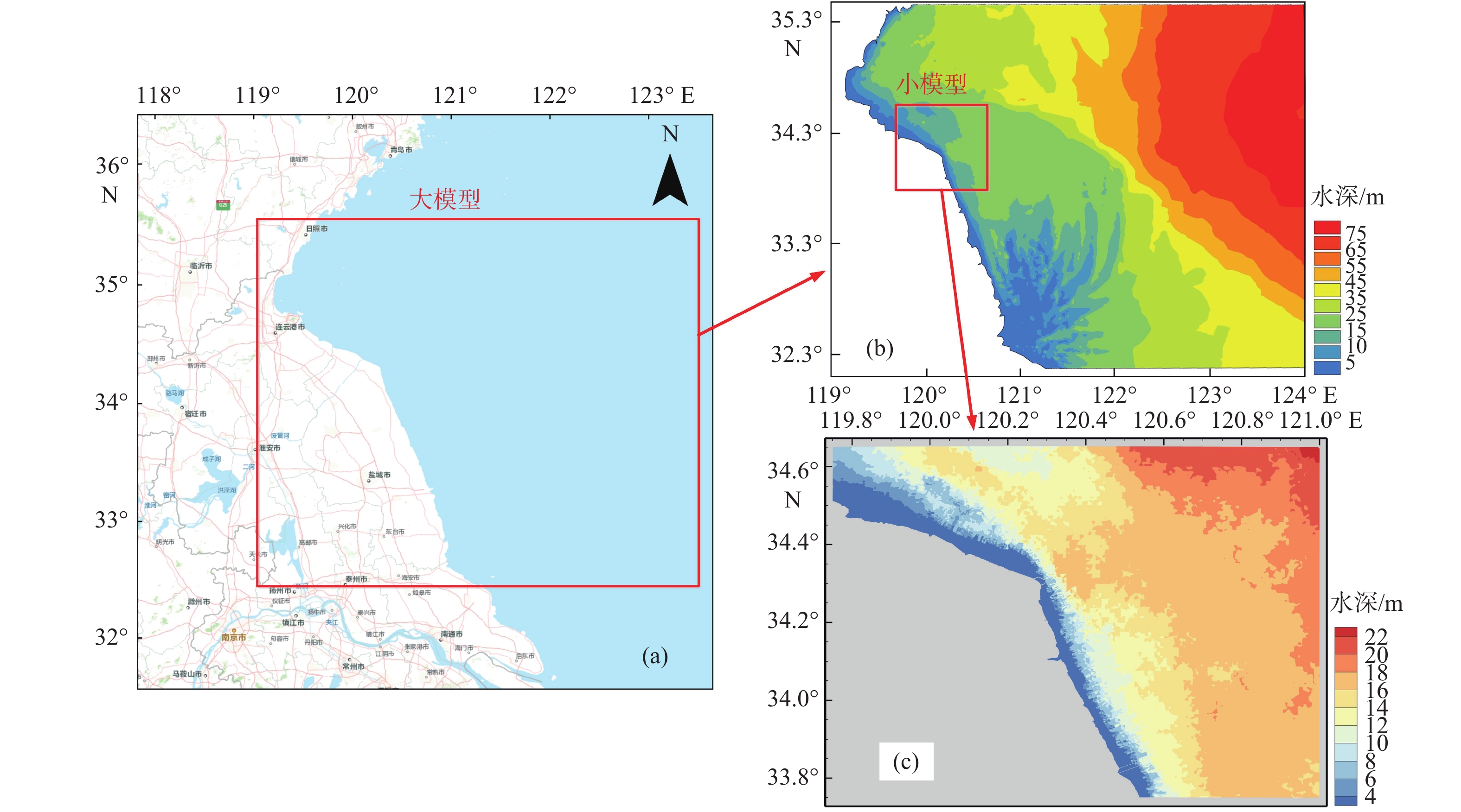
Figure 1.
Location of the old Yellow River mouth (a),water depth distribution in the area calculated by the large model(b)and water depth distribution in the area calculated by the small model (c)in the study area
-
Figure 2.
Changes before and after the port construction
-
Figure 3.
The griddings of the calculation area for the large and small models
-
Figure 4.
Tide level verification
-
Figure 5.
Validation of the small model for velocity
-
Figure 6.
Verification of suspended sand concentration at measurement points 1-5 at spring tide (a) and neap tide (b)
-
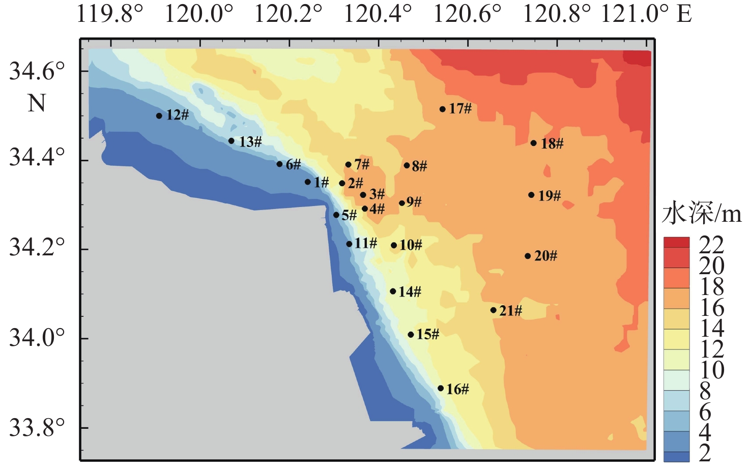
Figure 7.
Feature point location for tide analysis
-
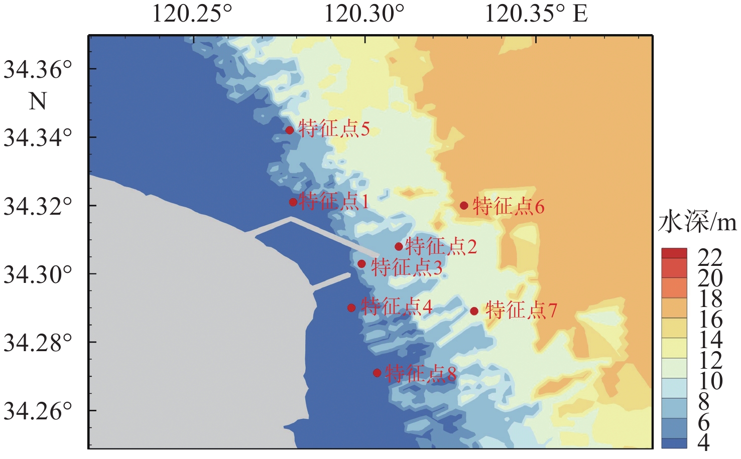
Figure 8.
Location of feature point for sedimentation dynamics analysis
-
Figure 9.
The flow field changes in the calculation area before and after the construction
-
Figure 10.
The streamline changes in the calculation area before and after the construction
-
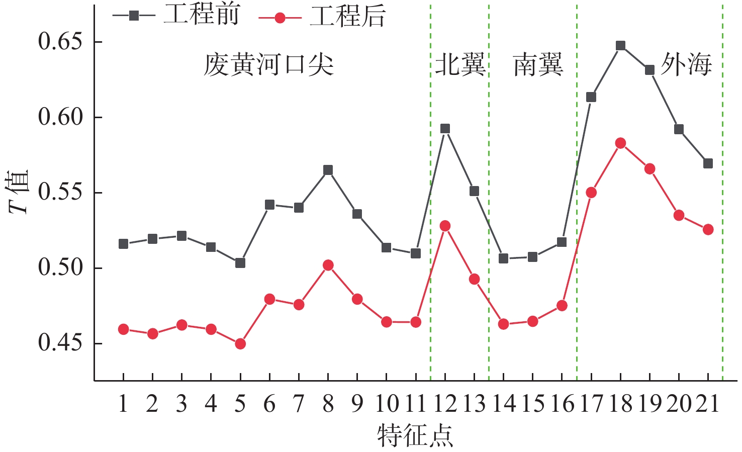
Figure 11.
Change in the T-value of each feature point before and after the construction
-
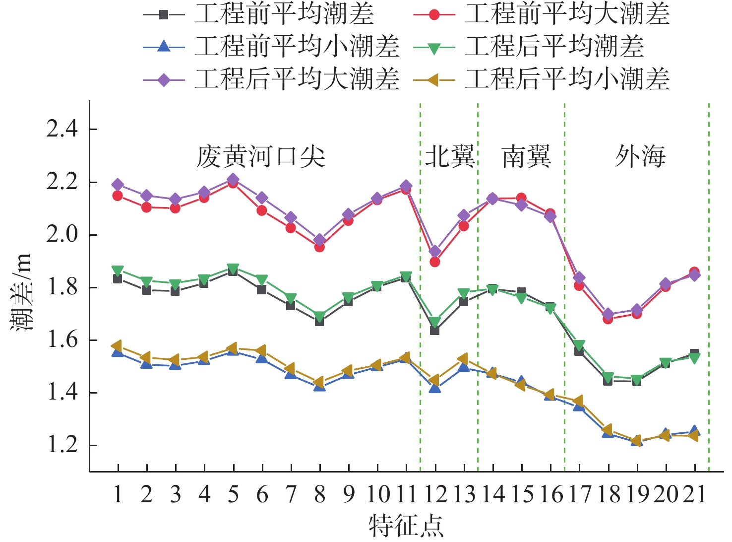
Figure 12.
The tidal range at each feature point before and after the construction
-
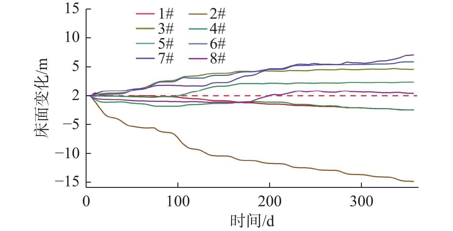
Figure 13.
Changes in seabed surface before and after the port construction
-
Figure 14.
Morphological changes of the seabed surface in feature points after the port construction
-
Figure 15.
Variations of water level, flow velocity, suspended sand concentration and seabed surface in feature points