
| Qingdao Institute of marine geology, China Geological Survey | Host |
| Citation: |
FU Jiani, LIU Honghua, DONG Jie, DOU Yanguang, MING Qiang, LIU Haisong, XIA Weiqiang, ZOU Liang. APPLICATION OF REMOTE SENSING TECHNOLOGY TO URBAN GEOLOGICAL SURVEY AT QINGDAO CITY[J]. Marine Geology Frontiers, 2021, 37(9): 69-78. doi: 10.16028/j.1009-2722.2021.108

|
APPLICATION OF REMOTE SENSING TECHNOLOGY TO URBAN GEOLOGICAL SURVEY AT QINGDAO CITY
-
Abstract
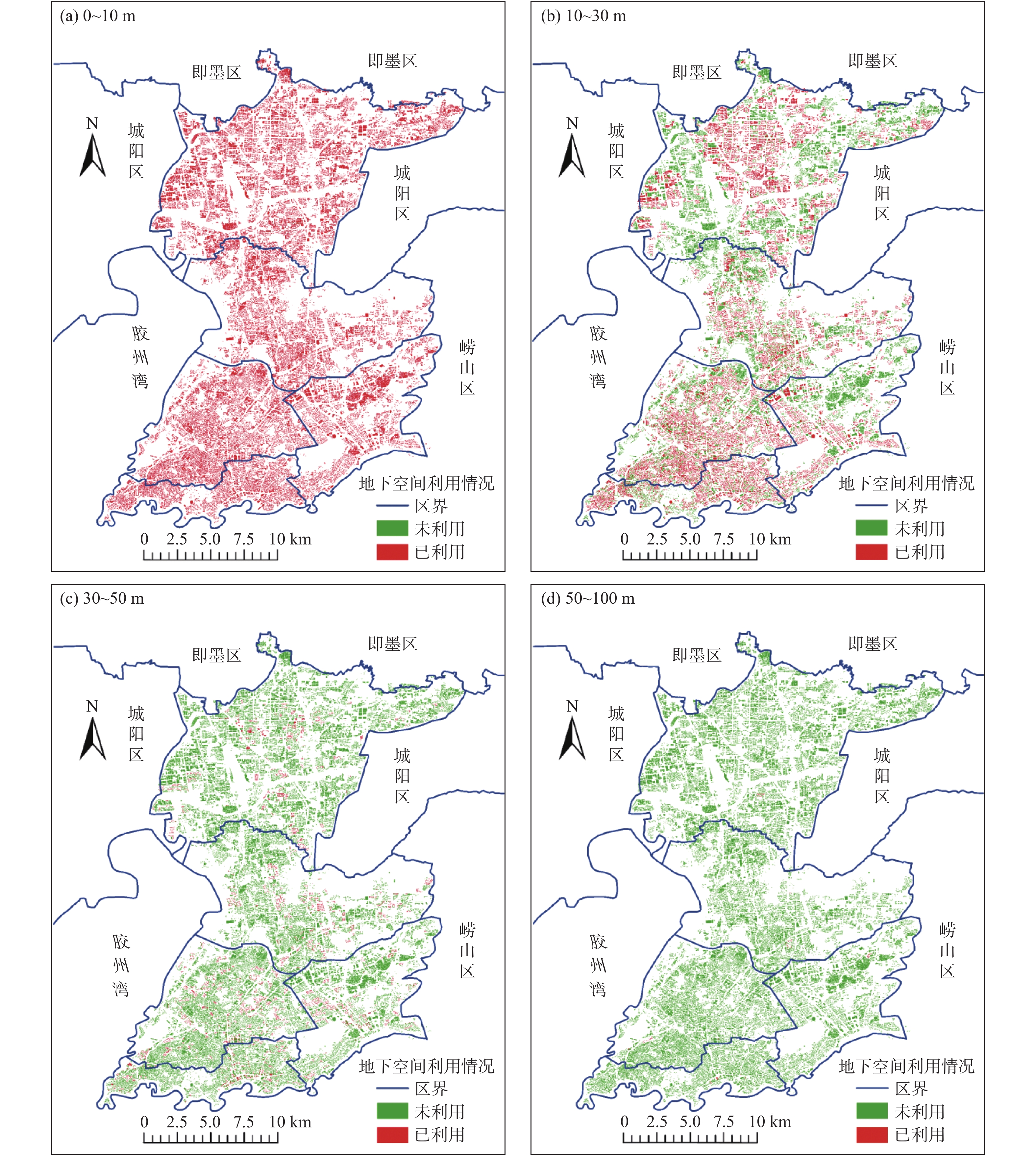
Remote sensing technology is now efficiently used in urban geological survey. It may provide more macroscopic and intuitive data support for urban geological mapping and specific investigations of some geological problems. In the Project on Urban Geological Survey of Qingdao City, the method of remote sensing is widely used and has achieved a lot. Firstly, based on the multi-period high accuracy remote sensing images, the remote sensing interpretation marks for Jiaozhou Bay are established and the regional geological map of Jiaozhou Bay recompiled. Secondly, the distribution of artificial reclaimed land around Jiaozhou Bay is identified. And the third, a preliminary estimation of underground space resources is made available with remote sensing data for the depth of 0~10 m, 10~30 m, 30~50 m and 50~100 m respectively of the main urban area of Qingdao city. It is proposed that 10~50 m underground is the potential layer for expansion of underground space. Our practice demonstrates that the results are very useful to realize the purpose of geological survey, to improve the work efficiency, and to ensure the integrity and accuracy of results. The remote sensing technology may also provide references for solving of some specific urban geological problems.
-

-
References
[1] 邢丽霞, 葛伟亚, 周平. 地质调查精准支撑城市高质量发展[N]. 中国自然资源报, 2020-12-7(7). [2] 黄敬军,赵增玉,姜素,等. 自然资源管理视角下江苏城市地质调查工作新思考[J]. 地质评论,2020,66(6):1609-1618. [3] 薛重生,贾锦生,张志. 义乌市城市地质调查与遥感技术应用[J]. 地质科技情报,2003(2):99-106. [4] 姜月华,周权平,陈立德,等. 长江经济带地质环境综合调查工程进展与主要成果[J]. 中国地质调查,2019,6(5):1-20. [5] 于学政,杨日红,贲卫平. 遥感技术在城市地质调查中的应用[J]. 地质通报,2003,22(8):580-588. doi: 10.3969/j.issn.1671-2552.2003.08.006 [6] 闫颖,陈有炘,孟勇,等. 遥感技术在东天山大黑山地区地质填图中的应用[J]. 西北地质,2015,48(2):231-237. doi: 10.3969/j.issn.1009-6248.2015.02.024 [7] 山克强,潘明,林宇. 无人机航空遥感地质解译在岩石地层单元识别中的应用[J]. 地质力学学报,2016,22(4):933-942. doi: 10.3969/j.issn.1006-6616.2016.04.011 [8] 陈立泽,徐岳仁. 宣化盆地高光谱遥感第四系地层分类提取初步研究[J]. 湘潭大学学报(自然科学版),2015,37(1):81-86. [9] 王静雅,任升莲. 北秦岭构造带断裂遥感解译及其构造意义[J]. 地质科学,2016,51(4):1101-1113. [10] 谢小平,白毛伟,陈芝聪,等. 龙门山断裂带北东段活动断裂的遥感影像解译及构造活动性分析[J]. 国土资源遥感,2019,31(1):237-246. [11] 孙世瑞. 遥感在断裂构造中的应用[J]. 高原地震,2018,30(3):25-28. doi: 10.3969/j.issn.1005-586X.2018.03.005 [12] 支瑞荣,刘德卫. 基于遥感技术的工程地质条件调查[J]. 科技创新与应用,2017,203(19):85-86. [13] 费美高,许模. 应用遥感图像信息研究青岛地区水文地质问题[J]. 成都理工学院学报,1996(1):39-48. [14] 林健. 西部高精度遥感地质调查取得重要进展[J]. 西部资源,2014,60(3):54. [15] 王辉,汤洪志,许志彬,等. 江西某地区遥感地质解译[J]. 西部探矿工程,2019,31(3):127-128,133. [16] 侯珂. 遥感技术在鲁西南地区地热资源勘查的应用[J]. 城市地质,2018,13(1):69-72. doi: 10.3969/j.issn.1007-1903.2018.01.012 [17] 周丹坤,李晓昭,常晓军,等. 基于ArcGIS的地下空间资源禀赋评价[J]. 城市地质,2019,14(3):14-20. doi: 10.3969/j.issn.1007-1903.2019.03.003 [18] 邸亮. 遥感技术在森林资源图像识别中的应用[J]. 城市地理,2017(24):193. doi: 10.3969/j.issn.1674-2508.2017.24.132 [19] 卜程丹. 遥感技术在土地资源评价中的应用[J]. 城市地理,2017(24):192. doi: 10.3969/j.issn.1674-2508.2017.24.131 [20] 张兵,崔希民,赵彦博,等. 基于High-1卫星影像的土地整治遥感监测方法研究与实践[J]. 农业工程学报,2015(20):98. [21] 彭远新,邓振利,姜亚俊,等. 近50年莱州湾南岸海岸线变迁遥感监测研究[J]. 安徽农业科学,2019,47(3):54-56. doi: 10.3969/j.issn.0517-6611.2019.03.018 [22] 李刚,孙桂华,姚永坚,等. 三沙湾海岸线时空演变[J]. 吉林大学学报(地球科学版),2019,49(1):196-205. [23] 张云芝,张千力,胡云锋. 2010—2017年珠江河口海岸线遥感监测和动态变化分析[J]. 海洋通报,2019,38(2):217-224. doi: 10.11840/j.issn.1001-6392.2019.02.013 [24] 王绪龙,王世进,刘奇志,等. 山东省旅游地质资源遥感调查成果及潜力展望[J]. 中国地质调查,2018,5(6):90-96. [25] 邢宏. 基于遥感的青岛胶州湾湿地信息提取与分析[J]. 科技经济导刊,2018,26(6):20-22. [26] 周玉明,赵志峰,刘晓磊. 天津市区古河道工程特性及对地铁工程的影响[J]. 勘察科学技术,2017,213(6):42-46,50. doi: 10.3969/j.issn.1001-3946.2017.06.010 [27] 张竞,马震,吴爱民,等. 基于岩性光谱特征的雄安新区地面古河道识别研究[J]. 地球学报,2018,39(5):542-548. doi: 10.3975/cagsb.2018.071003 [28] 叶成名,李尧,崔鹏,等. 高光谱遥感地质灾害信息提取系统设计与实现[J]. 中国地质灾害与防治学报,2018,29(5):89-94. [29] 魏少伟. 线性工程地质灾害监测新技术及发展趋势[J]. 铁道建筑,2019,59(2):57-63. doi: 10.3969/j.issn.1003-1995.2019.02.15 [30] 王少林. 基于遥感影像的矿山地质灾害形成机理分析[J]. 世界有色金属,2017,490(22):183-185. [31] 段瑞琪,董艳辉,周鹏鹏,等. 高光谱遥感水文地质应用新进展[J]. 水文地质工程地质,2017,44(4):23-29. [32] 贾永红,李德仁,孙家柄. 多源遥感影像数据融合[J]. 遥感技术与应用,2000(1):41-44. doi: 10.3969/j.issn.1004-0323.2000.01.010 [33] 周圆心,何静,徐旸. 基于遥感影像的城市地下空间资源量估算方法[J]. 城市地质,2017,12(3):87-90. doi: 10.3969/j.issn.1007-1903.2017.03.017 [34] 田毅,陈建平,王丽梅. 北京市中心城区地下空间潜在资源量三维评价[J]. 中国土地科学,2012,26(11):40-44,97. doi: 10.3969/j.issn.1001-8158.2012.11.007 -
Access History
Figures(11)
Tables(4)

Export File
Citation
FU Jiani, LIU Honghua, DONG Jie, DOU Yanguang, MING Qiang, LIU Haisong, XIA Weiqiang, ZOU Liang. APPLICATION OF REMOTE SENSING TECHNOLOGY TO URBAN GEOLOGICAL SURVEY AT QINGDAO CITY[J]. Marine Geology Frontiers, 2021, 37(9): 69-78. doi: 10.16028/j.1009-2722.2021.108
Format
Content
 DownLoad:


-
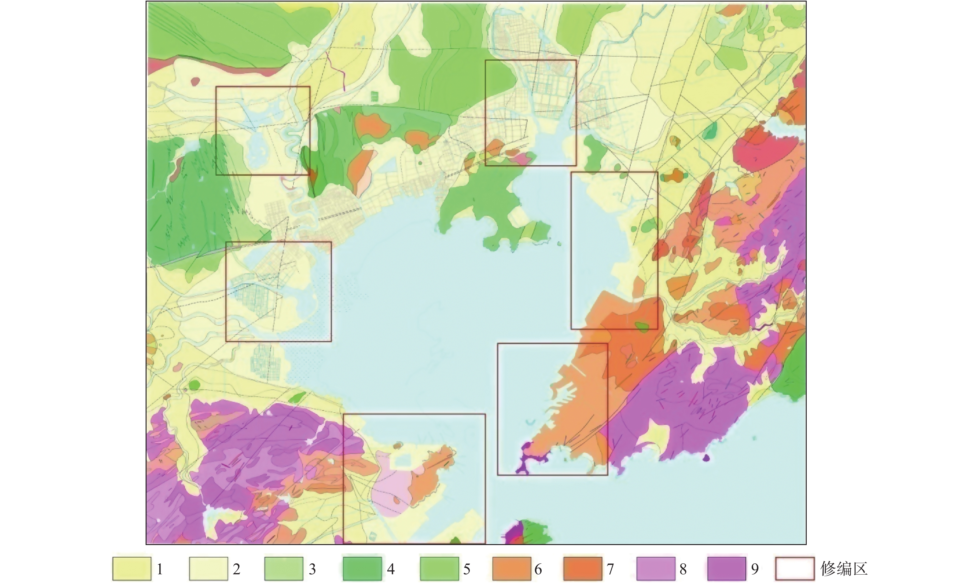
Figure 1.
The revised regional geological map of Jiaozhou Bay
-
Figure 2.
Landsat and PCA analysis of false color images
-
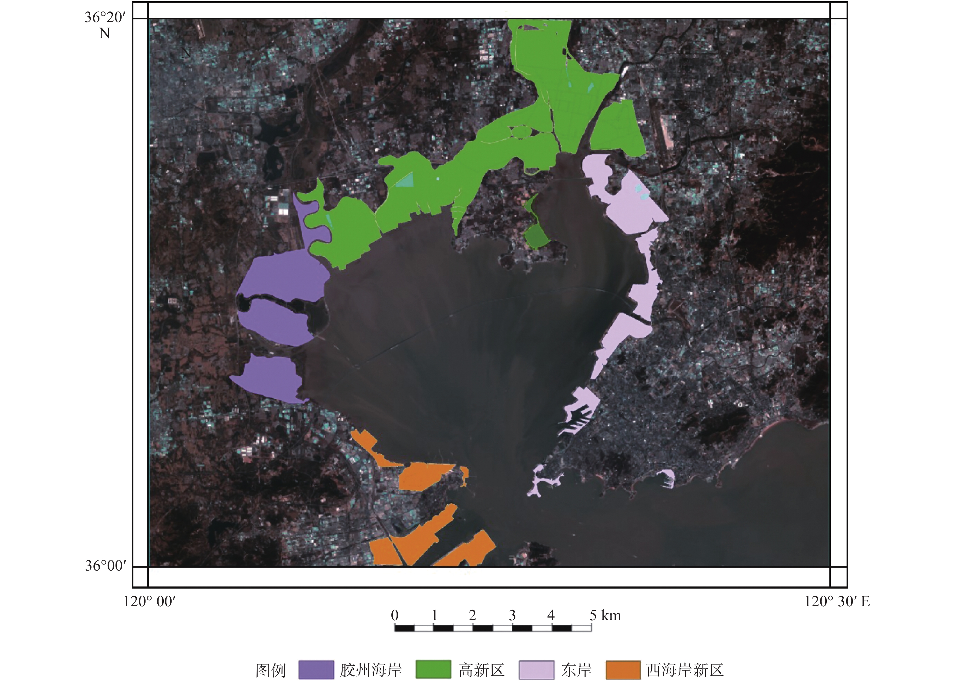
Figure 3.
Land reclamation areas from 1983 to 2018
-
Figure 4.
The remote image of main urban area of Qingdao
-
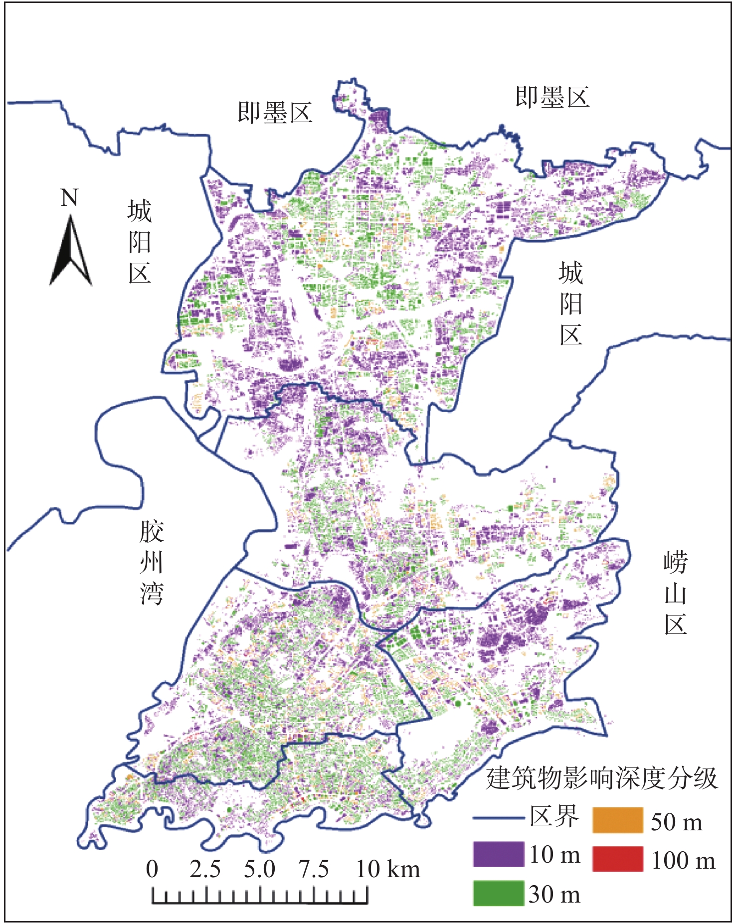
Figure 5.
Level map of building influenced depth
-
Figure 6.
Utilization of underground space resources in the main urban area of Qingdao
-
Figure 7.
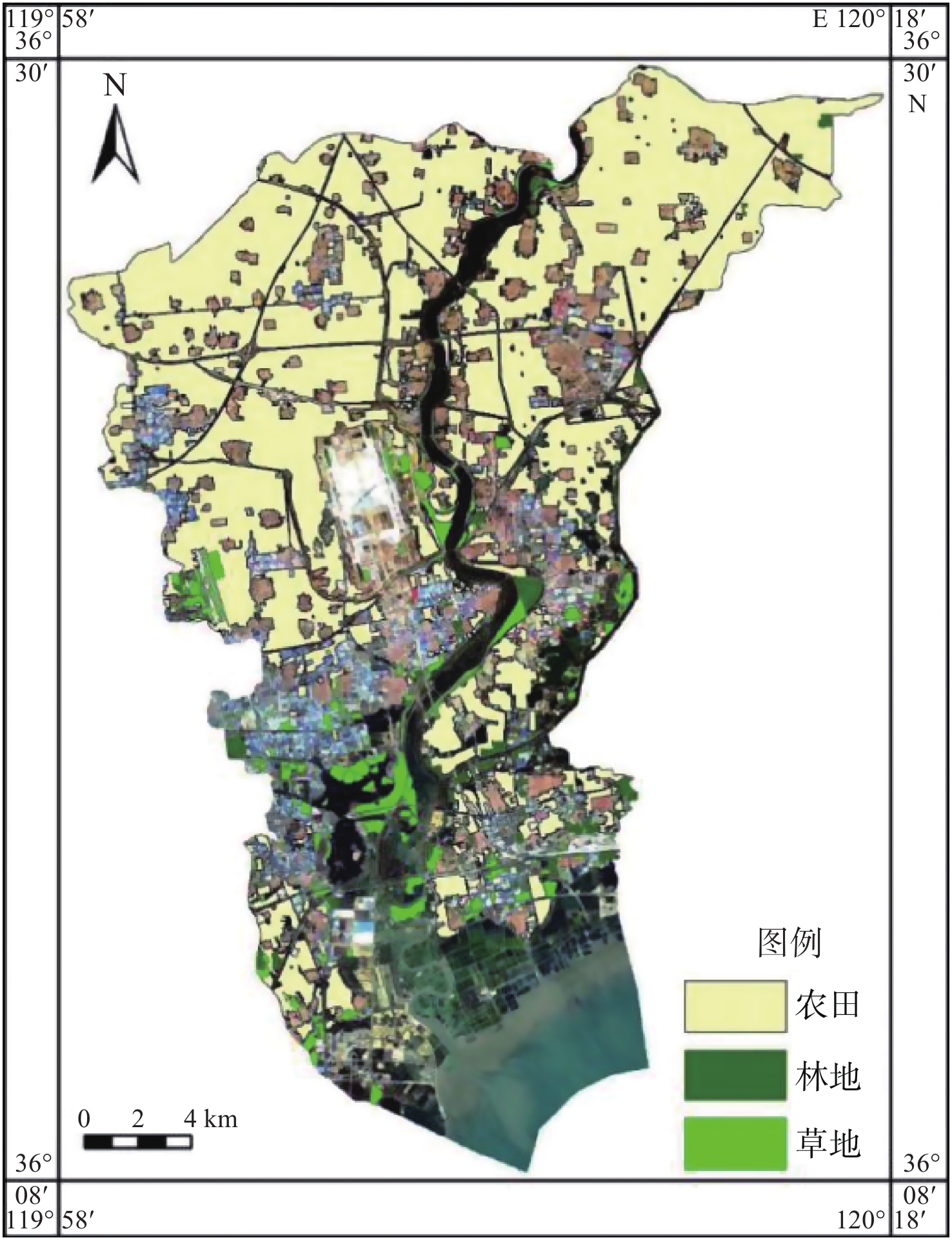
Remote sensing interpretation map of wetland in Dagu River basin
-
Figure 8.
Remote sensing interpretation map of vegetation in Dagu River basin
-
Figure 9.
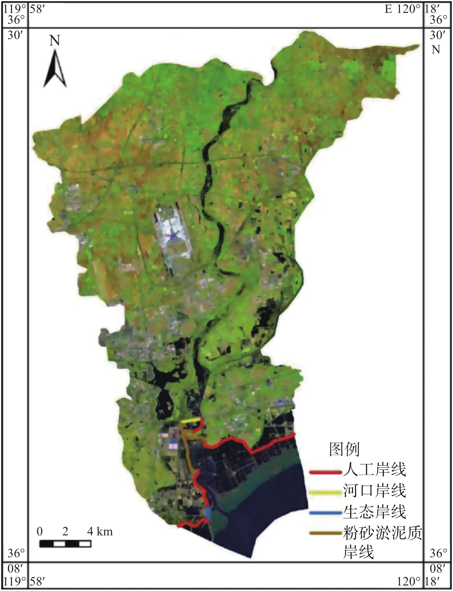
Remote sensing interpretation map of coastline in the lower reaches of Dagu River
-
Figure 10.
Revised map of the Xian river wetland in Pingdu
-
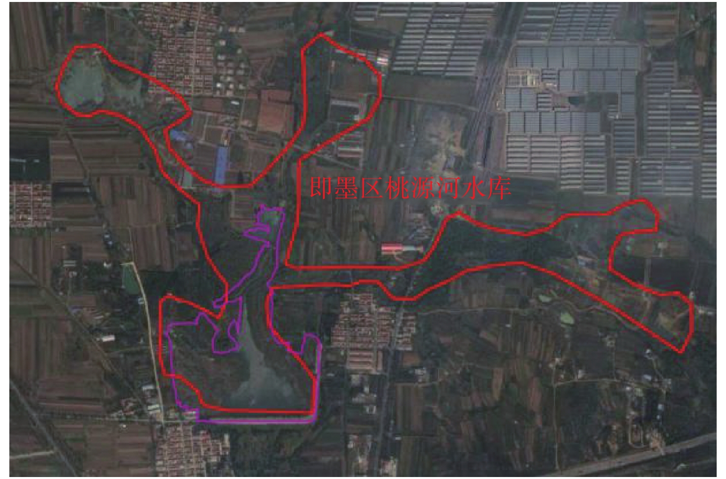
Figure 11.
The revised map of Taoyuan river reservoir wetland in Jimo