
| Qingdao Institute of marine geology, China Geological Survey | Host |
| Citation: |
LI Jinyuan, LIU Jianmin, FANG Nianqiao, TANG Qichao, CAO Shugang, YAO Xinglong. SUBMARINE TOPOGRAPHY AND SEDIMENTARY CHARACTERISTICS OF OFFSHORE WIND FARM IN HEISHAN ISLAND OF SHANDONG[J]. Marine Geology Frontiers, 2020, 36(10): 84-92. doi: 10.16028/j.1009-2722.2020.057

|
SUBMARINE TOPOGRAPHY AND SEDIMENTARY CHARACTERISTICS OF OFFSHORE WIND FARM IN HEISHAN ISLAND OF SHANDONG
-
Abstract
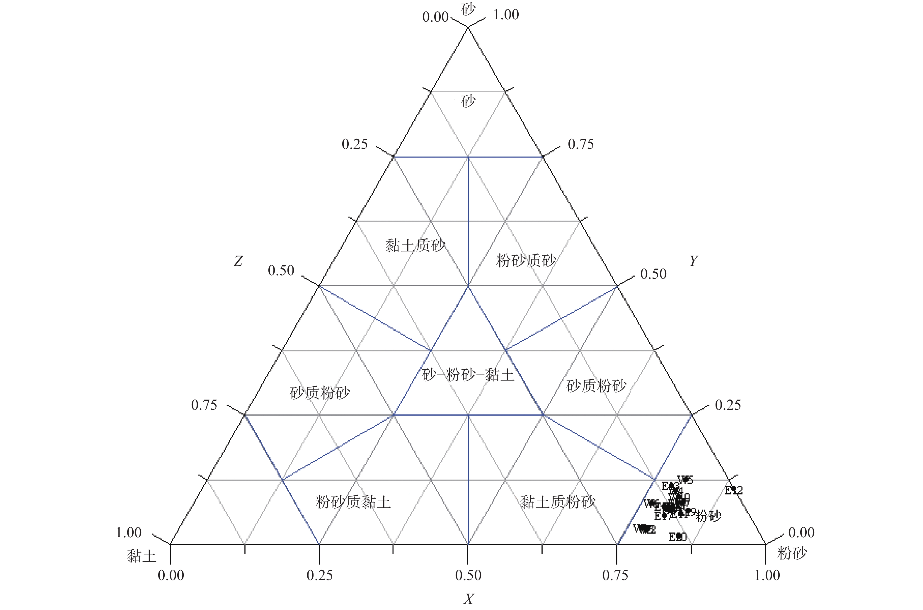
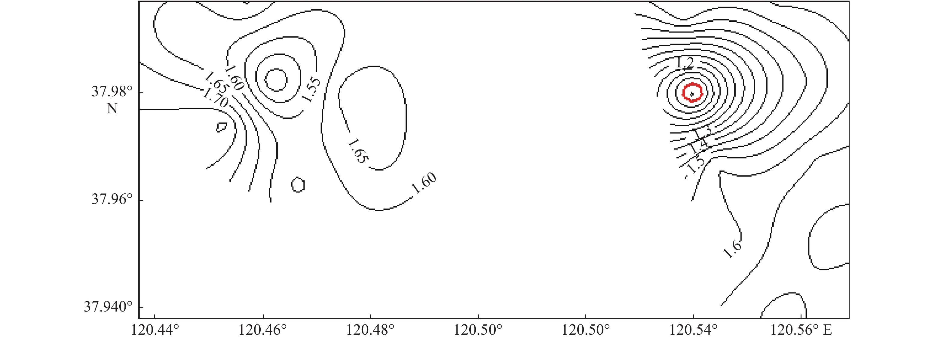
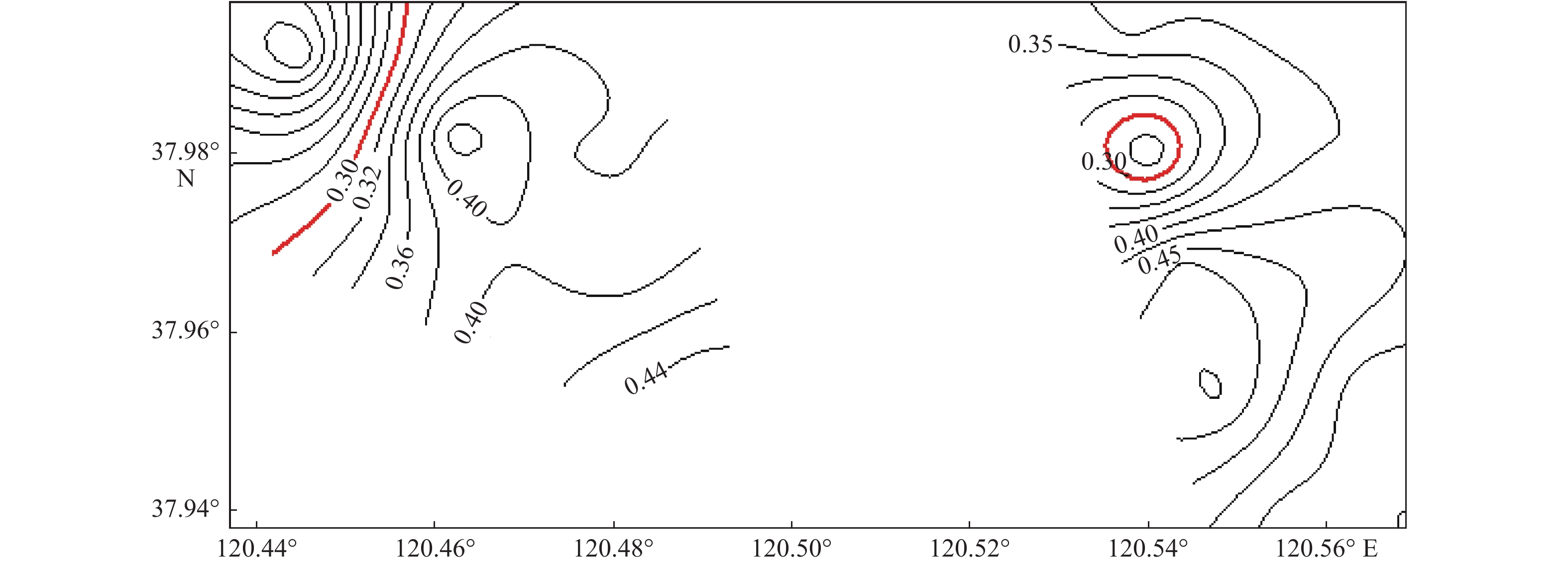
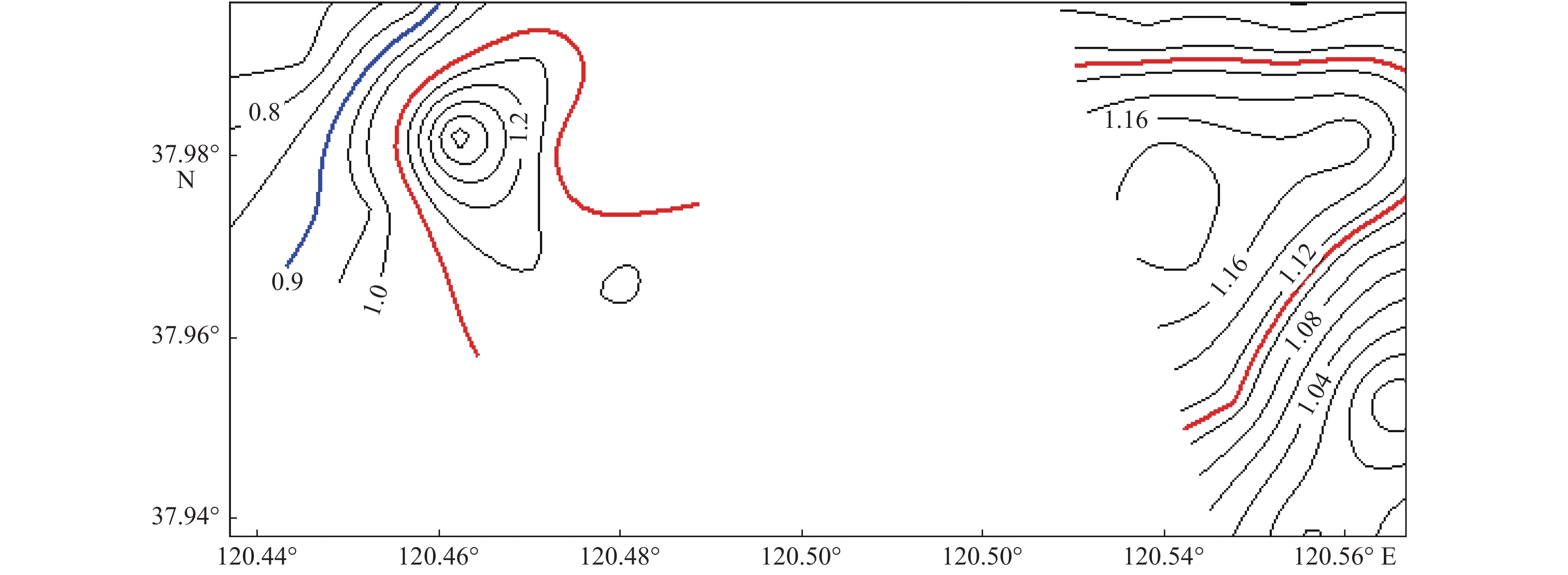
The sea area off the Shandong Peninsula is rich in wind resources and there are excellent conditions for large-scale development of wind energy. In order to understand the topography and sediment distribution patterns of the seabed, so as to promote the development of offshore wind farms smoothly, the sea area near the Heishan island was selected as a case for geological study. An integrated geological and geophysical survey was then undertaking in the selected area. The survey data suggests that the seafloor topography of the study area is rather gentle and the water depth changes from 10 m to 25 m, 17.5 m on average. The sediment in the study area is cyan gray, gray and light brown in color and dominated by silty sand which covers over 75% of the whole area. The kurtosis of the sediment varies from flat to medium to sharp. In the west part of the study area, the sorting of the seafloor sediment changes from 1.35 up to 1.80. while in the east part the sorting of the sea bottom sediment varies from 0.90 to 1.75. The mean grain size of bottom sediments of the whole study area ranges from 4.3Φ to 5.9 Φ and is silt dominated. The topography and sediment characteristics reflect that the study area is an area with weak hydrodynamic effect and therefore suitable for offshore wind power development and other kinds of sub-bottom constructions.
-

-
References
[1] 孙 雷,汪 锋,张 雯,等. 海上风电运维:从近海走向深远海域[J]. 太阳能,2018(6):6-10. [2] 杨红生,茹小尚,张立斌,等. 海洋牧场与海上风电融合发展:理念与展望[J]. 中国科学院院刊,2019,34(6):700-707. [3] 曾 亮,储韬玉,王占华,等. 海上风电勘测中的物探技术[J]. 工程勘察,2019,47(7):66-72. [4] 高 抒,Collins M. 沉积物粒径趋势与海洋沉积动力学[J]. 中国科学基金,1998,12(4):241-246. [5] Ashley G M. Classification of large-scale subaqueous bedforms:a new look at an old problem[J]. Journal of Sedimentary Research,1990,60(1):160-172. doi: 10.2110/jsr.60.160 [6] 林纪江,胡日军,朱龙海,等. 潮流作用下蓬莱近岸海域悬浮泥沙的时空分布及变化特征[J]. 海洋地质前沿,2017,33(12):13-23. [7] 中华人民共和国国家质量监督检疫总局. GB/T 12763.8-2007 海洋调查规范 第8部分: 海洋地质地球物理调查[S]. 北京: 中国标准出版社, 2008. [8] McLaren P. An interpretation of trends in grain size measurements[J]. Journal of Sedimentary Petrology,1981,51:611-624. [9] Livingstone I,Wiggs G F S,Weaver C M. Geomorphology of desert sand dunes:a review of recent progress[J]. Earth-Science Reviews,2007,80(3/4):239-257. [10] 左书华,韩志远,许 婷. 烟台套子湾海域表层沉积物粒度分布特征及其动力响应[J]. 泥沙研究,2013(5):41-46. [11] 陈燕萍,李 琰. 舟山DZ-1钻孔沉积物粒度特征与沉积环境辨别[J]. 海洋学研究,2018,36(4):53-59. [12] 刘春秀. 烟台近海海底表层沉积物粒度分布特征[D]. 青岛: 中国海洋大学, 2010. [13] Doeglas D J. Loess deposits of Mississippi. Krinitzsky E L,Turnbull W J.1967. Geological Society of America,Boulder,Colo. (Special Paper 94),64 pp.,U.S. $3.50[J]. Earth-Science Reviews,1968,4:71. [14] 汤世凯,于剑峰,李金鹏,等. 烟台芝罘湾底质沉积物粒度特征和沉积动力环境研究[J]. 山东国土资源,2020,36(1):22-28. [15] 贾海林,刘苍字,杨 欧. 长江口北支沉积动力环境分析[J]. 华东师范大学学报(自然科学版),2001,1(1):90-96. [16] 韦钦胜,于志刚,冉祥滨,等. 黄海西部沿岸流系特征分析及其对物质输运的影响[J]. 地球科学进展,2011,26(2):145-156. [17] 张秀芝, 朱 蓉. 中国近海风电场开发指南[M]. 北京: 气象出版社, 2010: 60-61. [18] 张 伟. 渤海海峡南部海域地貌特征及控制因素研究[D]. 青岛: 中国海洋大学, 2014. [19] Pejrup M. The triangular diagram used for classification of estuarine sediments: a new approach[M]//de Boer P L, van Gelder A, Nio S D. Tide-Influenced Sedimentary Environments and Facies. Netherlands: D. Reidel Publishing, 1988: 289-300. -
Access History
Figures(10)
Tables(3)

Export File
Citation
LI Jinyuan, LIU Jianmin, FANG Nianqiao, TANG Qichao, CAO Shugang, YAO Xinglong. SUBMARINE TOPOGRAPHY AND SEDIMENTARY CHARACTERISTICS OF OFFSHORE WIND FARM IN HEISHAN ISLAND OF SHANDONG[J]. Marine Geology Frontiers, 2020, 36(10): 84-92. doi: 10.16028/j.1009-2722.2020.057
Format
Content
 DownLoad:


-
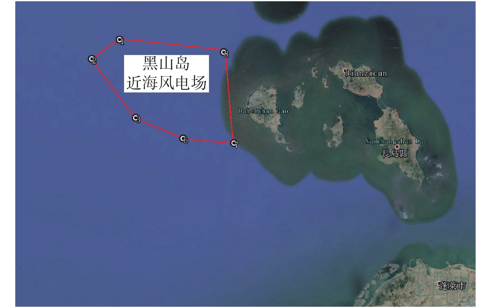
Figure 1.
The location map of the study area
-
Figure 2.
Regional geological structure
-
Figure 3.
The location of tide level observation points
-
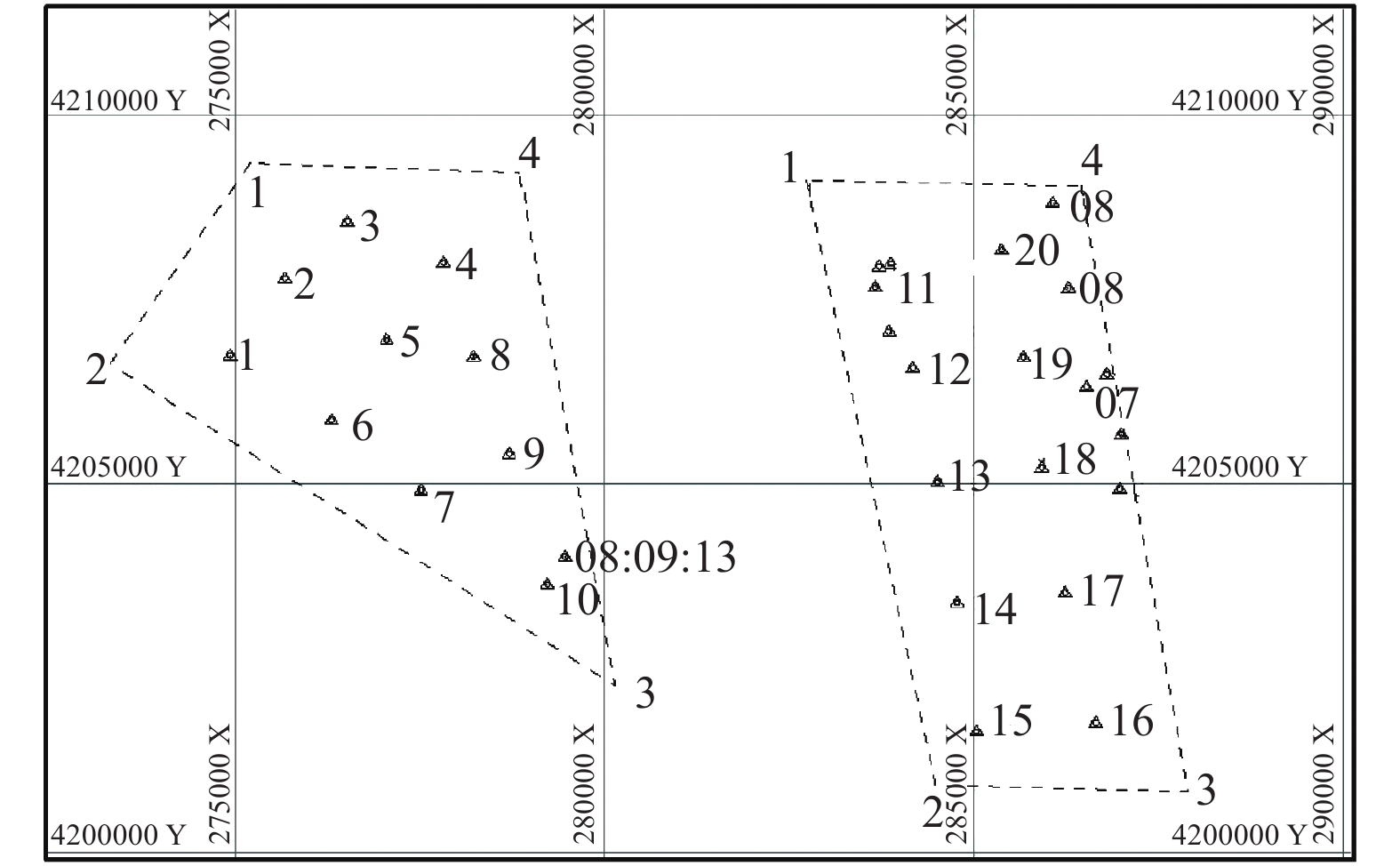
Figure 4.
The location map of bottom sampling stations
-
Figure 5.
The bathymetric topographic map of the whole area
-
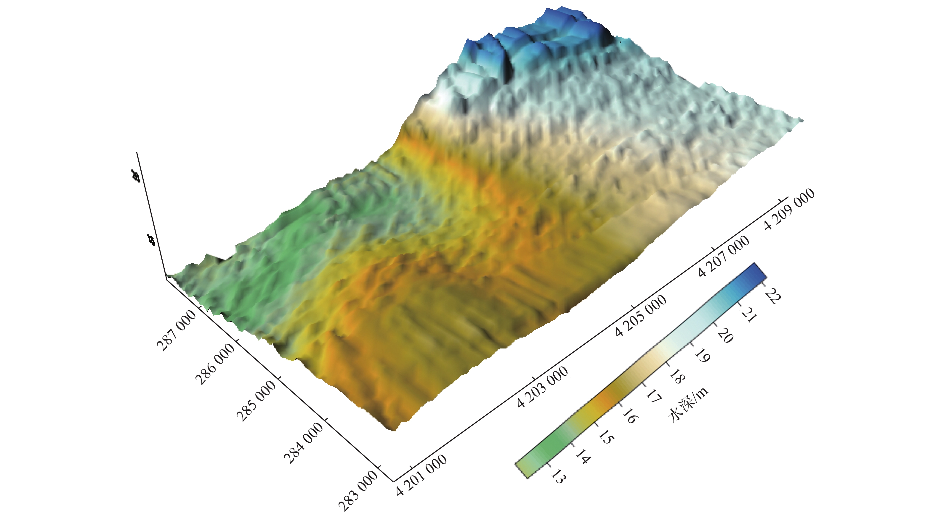
Figure 6.
3D topography of study area
-
Figure 7.
Classification of sediments for the study area
-
Figure 8.
Isoline map of sorting coefficient of the surface sediments
-
Figure 9.
Isoline map of skewness of the surface sediments
-
Figure 10.
isoline map of kurtosis of the surface sediments