
| Qingdao Institute of marine geology, China Geological Survey | Host |
| Citation: |
YU Deshui, SHAN Rui, MEI Sai, YIN Ping, ZHOU Liangyong. HIGH PRECISION COASTAL EROSION MONITORING BY USING GNSS-RTK TECHNOLOGY[J]. Marine Geology Frontiers, 2019, 35(9): 45-51. doi: 10.16028/j.1009-2722.2019.09008

|
HIGH PRECISION COASTAL EROSION MONITORING BY USING GNSS-RTK TECHNOLOGY
-
Abstract
Based on a brief review of coastal erosion monitoring practices both abroad and at home, we made an introduction to the principles and operation of the GNSS-RTK technology in this paper. All the results of the monitoring data with different topography are described and evaluated. Comparison is also made with other methods. The results prove that GNSS-RTK technology is an appropriate method to achieve high-precision coastal zone erosion monitoring.
-
Keywords:
- GNSS-RTK Technology /
- coastal zone /
- erosion monitoring /
- high-precision
-

-
References
[1] 任美锷.海平面研究的最近进展[J].南京大学学报(自然科学版), 2000, 36(3):269-279. doi: 10.3321/j.issn:0469-5097.2000.03.001 [2] Russell R J.Geomorphology of the rhone delta[J].Annais of the Association of American Geographers, 1942, 32:149-254. [3] Shepard F P, Inman D.Nearshore water circulation related to Bottom topography an waveref raction[J].Transaction of the American Geophysical Union, 1950, 31:196-212. doi: 10.1029/TR031i002p00196 [4] Harrison W, Krumbein W C.Interaction of the beach-ocean-atmosphere system at Virginia Beach, Virginia[M].United States Army Coastal Engineering Research CE, 1964:102-110. [5] Wright L D, Short AD, Green M O.Short-term changes in the morphodynamic states of beaches and surf zones:an ex-ample predictive model[J].Marine Geology, 1985, 62(3/4):339-364. [6] Wright L D, Short A D.Morphodynamic variability of surfzones and beaches:asynthesis[J].Marine Geology, 1984, 56(1/4):93-118. [7] 张慧霞, 庄大昌, 娄全胜.基于土地利用变化的东莞市海岸带生态风险研究[J].经济地理, 2010, 30(3):489-493. [8] 谢宏全, 高祥伟.连云港海岸带土地利用/覆盖变化与驱动力分析[J].海洋科学, 2011, 35(11):52-57. [9] Blodget H W, Taylor P T, Roark J H.Shoreline changes a-long the Rosetta-Nile Promotory:Monigztoring with sa-telites observations[J].Marine Geology, 1991(1/2):67-77. [10] 田会波, 印萍, 阳凡林.海南省万宁东部砂质海岸侵蚀特征分析[J].海洋地质与第四纪地质, 2018, 38(4):44-55. [11] 田会波, 印萍, 贾永刚.万宁东部海岸侵蚀现状及原因分析[J].海洋环境科学, 2016, 35(5):718-724. -
Access History
Figures(8)

Export File
Citation
YU Deshui, SHAN Rui, MEI Sai, YIN Ping, ZHOU Liangyong. HIGH PRECISION COASTAL EROSION MONITORING BY USING GNSS-RTK TECHNOLOGY[J]. Marine Geology Frontiers, 2019, 35(9): 45-51. doi: 10.16028/j.1009-2722.2019.09008
Format
Content
 DownLoad:

-
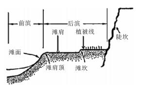
Figure 1.
A sketch of a beach profile
-
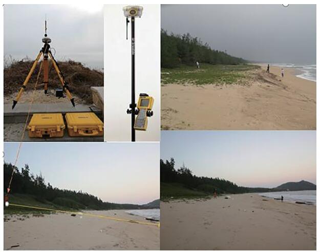
Figure 2.
Pictures showing the monitoring stations along a coastal profile
-
Figure 3.
Monitoring of acoastal profile
-
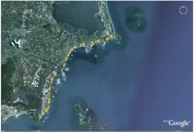
Figure 4.
Topographic map showing monitoring stations
-
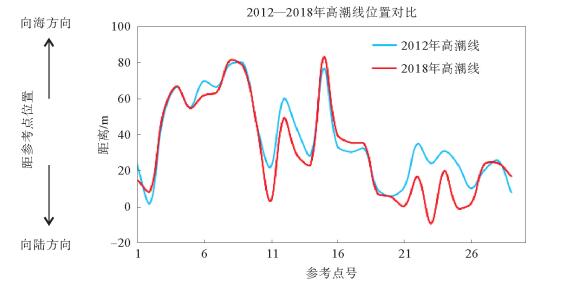
Figure 5.
Change of high tide in monitoring area
-
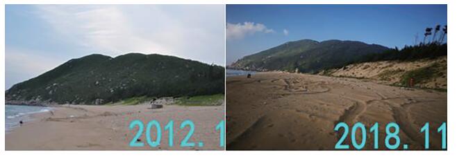
Figure 6.
Coastal erosion at esame location with time(severely changing coast)
-
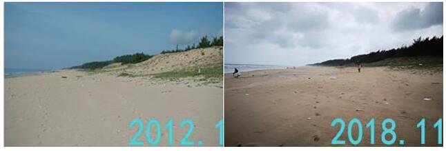
Figure 7.
Erosion at the same location with time(Slowly changing coast)
-
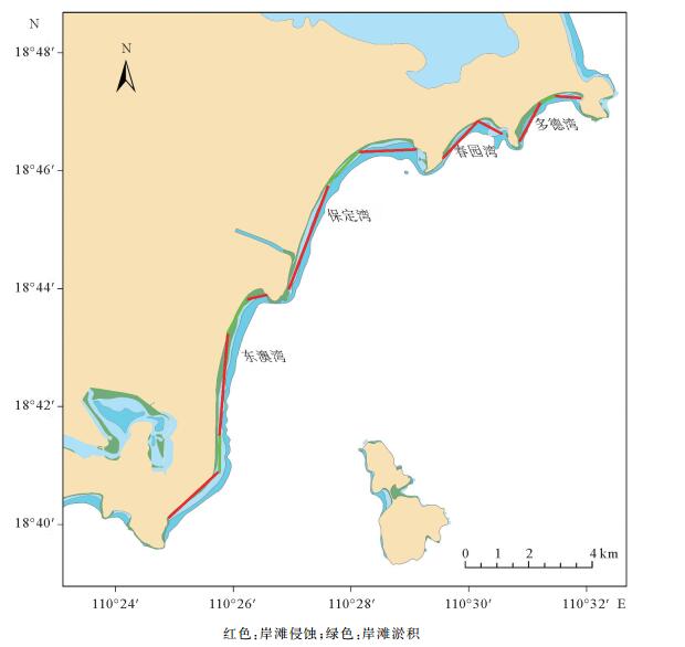
Figure 8.
Distribution of coastal erosion and siltation