
| Citation: |
ZHAO Shaopan, YANG Sen, ZHANG Dongxing, CHANG Cheng, YAN Jiazhe, LIU Nian, MA Qianqian, ZHANG Xi. 2025. Groundwater Source Identification Based on Hydrochemistry and D, 18O Isotopes in a Mine in Western Henan Province. Northwestern Geology, 58(2): 313-322. doi: 10.12401/j.nwg.2024014

|
Groundwater Source Identification Based on Hydrochemistry and D, 18O Isotopes in a Mine in Western Henan Province
-
Abstract
Through the hydrology survey of the study area, the groundwater in the tunnel is found to be structural fissure water, the surface water and tunnel water are sampled and analyzed in the wet season and dry season respectively. The hydrochemical characteristics show that the anions and cations in surface water change significantly with the high and low water periods. However, the changes in the content of anions and cations in groundwater are small, and the chemical properties of the water are relatively stable. By comparing and analyzing the water inflow and isotopes of 420 section and reservoir in wet season of 2021, it is speculated that the reservoir water participates in groundwater activities in this section during special hydrological years. However, there are significant differences in the hydrochemical and D, 18O isotope characteristics between surface water and groundwater in other areas, indicating that the participation of surface water in groundwater activities is not significant. In summary, the groundwater in the study area has a relatively independent aquifer system, mainly supplied by structural fissure water within the rock layers. At ordinary times, bedrock fissure water and brook water supply the reservoir water. When encountering a heavy rainstorm, the reservoir water level will rise above the groundwater level, and then the groundwater will be replenished. It is speculated that when the water level of the reservoir is greater than 535 m, surface water participates in individual groundwater activities in the individual section, but the total amount of water inflow is not large and overall controllable
-
Keywords:
- surface water /
- groundwater /
- structural fissure water /
- hydrochemistry /
- D, 18O isotope
-

-
References
[1] 高尚. 萧县旗杆楼铁矿充水水源识别与矿坑涌水量预测[D]. 合肥: 合肥工业大学, 2017. GAO Shang. Water Source identification and prediction of mine water inflow for Xiaoxian Qiganlou iron ore[D]. Hefei: Hefei University of Technology, 2017. [2] 刘丹, 杨立中, 李晓. 秦岭特长隧道地区同位素水文地质研究[J]. 成都理工学院学报, 2022, 29(3): 340−345. LIU Dan, YANG Lizhong, LI Xiao. Study of isotopic hydrogeology in the Qinling extra-long tunnel area[J]. Journal of Chengdu University Technology,2022,29(3):340−345. [3] 宋煜, 李保珠. 云南会泽铅锌矿区地下水化学和同位素分析[J]. 地质学报, 2018, 92(5): 1081−1089. SONG Yu, LI Baozhu. Hydrochemistry and isotopic analysis of groundwater in the Huize lead-zinc mining district, Yunnan[J]. Acta Geologica Sinica,2018,92(5):1081−1089. [4] 宋煜. 云南会泽铅锌矿区深部岩溶水特征及矿井涌水预测[D]. 昆明: 昆明理工大学, 2016. SONG Yu. Lead-zinc mine deep karst water features and the mine water gushing prediction in Huize Yunnan[D]. Kunming: Kunming University of Science and Technology, 2016. [5] 孙继平, 靳春海. 矿井水灾感知与水源判定方法研究[J]. 工矿自动化, 2019, 45(4): 1−5. SUN Jiping, JIN Chunhai. Research on methods of mine flood perception and water source determination[J]. Industry and Mine Automation,2019,45(4):1−5. [6] 王锐, 郝成元, 马守臣. 郑州市降水氢氧同位素组成特征研究[J]. 灌溉排水学报, 2014, 33(S1): 135−137. WANG Rui, HAO Chengyuan, MA Shouchen. Characteristics of hydrogen and oxygen isotopic compositions in precipitation of Zhengzhou city[J]. Journal of Irrigation and Drainage,2014,33(S1):135−137. [7] 王涛, 徐丽娜, 刘笑. 郑州大气降水氧同位素变化及水汽来源分析[A]. 创新驱动发展 提高气象灾害防御能力—第30届中国气象学会年会[C].2013. WANG Tao, XU Lina, LIU Xiao. Oxygen isotope variation and water vapor source analysis of atmospheric precipitation in Zhengzhou[A]. Innovation-driven development and improvement of meteorological disaster prevention capability-the 30th annual meeting of the Chinese Meteorological Society[C]. 2013. [8] 王新娟, 许苗娟, 韩旭, 等. 基于同位素和水化学的北京平谷盆地地下水循环研究[J]. 西北地质, 2023, 56(5): 127−139. WANG Xinjuan, XU Miaojuan, HAN Xu, et al. Study on groundwater cycle in Beijing Pinggu basin based on isotopes and hydrochemistry[J]. Northwestern Geology,2023,56(5):127−139. [9] 吴君毅, 刘洪, 欧阳渊, 等. 螺髻山北麓地下水化学特征与水质评价[J]. 西北地质, 2023, 56(5): 151−164. WU Junyi, LIU Hong, OUYANG Yuan, et al. Hydrochemical characteristics and water quality assessment of groundwater in northern foothill of Luoji mountains[J]. Northwestern Geology,2023,56(5):151−164. [10] 肖国强, 杨吉龙, 胡云壮, 等. 秦皇岛洋-戴河滨海平原海水入侵过程水文化学识别[J]. 安全与环境工程, 2014, 21(2): 32−39. doi: 10.3969/j.issn.1671-1556.2014.02.008 XIAO Guoqiang, YANG Jilong, HU Yunzhuang, et al. Hydrogeochemical recognition of seawater intrusion processes in Yang river and Dai river coastal plain of Qinhuangdao city[J]. Safety and Environmental Engineering,2014,21(2):32−39. doi: 10.3969/j.issn.1671-1556.2014.02.008 [11] 杨峰, 阮明, 张东强, 等. 海南省三亚市海坡地区热矿水同位素地球化学特征研究[J]. 地下水, 2018, 40(4): 15−17. doi: 10.3969/j.issn.1004-1184.2018.04.004 YANG Feng, RUAN Ming, ZHANG Dongqiang, et al. Study on the geochemical characteristics of hot mineral water isotope in Haipo district, Sanya city, Hainan province[J]. Ground Water,2018,40(4):15−17. doi: 10.3969/j.issn.1004-1184.2018.04.004 [12] 杨柱, 赵恰, 王军. 紫金山金铜矿地下开采矿坑涌水水源识别及防治方案[J]. 现代矿业, 2018, 34(5): 228−232. YANG Zhu, ZHAO Qia, WANG Jun. Water source identification of underground mine water inflow and treatment scheme of Zijinshan Au-Cu mine[J]. Modern Mining,2018,34(5):228−232. [13] 张瑞钢. 基于GIS 的潘一矿地下水环境特征分析及突水水源判别模型[D]. 合肥: 合肥工业大学, 2008. ZHANG Ruigang. GIS-based groundwater environmental characteristics analysisand discriminating model of water-inrush source —a casestudy of the Panyi coalfield, Huainan coalmine corporation[D]. Hefei: Hefei University of Technology, 2008. [14] 张洋, 马云东, 吴浩. 矿坑充水水源识别的EW-UCA 模型及应用[J]. 水文地质工程地质, 2014, 41(4): 32−37. ZHANG Yang, MA Yundong, WU Hao. EW-UCA model for identifying mine's water-filled source and its application[J]. Hydrogeology and Engineering Geology,2014,41(4):32−37. [15] 周慧. 我国大气降水中稳定同位素的多时空尺度变化及影响因素分析[D]. 长沙: 湖南师范大学, 2019. ZHOU Hui. Analysis on the variation characteristics and influencing factors of precipitation stable isotope in China under different spatial and temporal scales[D]. Changsha : Hunan Normal University, 2019. -
Access History

Figures(5)
Tables(1)

Export File
Citation
ZHAO Shaopan, YANG Sen, ZHANG Dongxing, CHANG Cheng, YAN Jiazhe, LIU Nian, MA Qianqian, ZHANG Xi. 2025. Groundwater Source Identification Based on Hydrochemistry and D, 18O Isotopes in a Mine in Western Henan Province. Northwestern Geology, 58(2): 313-322. doi: 10.12401/j.nwg.2024014
Format
Content
 DownLoad:


-
Figure 1.
Hydrogeological map of the study area
-
Figure 2.
Hydrogeological profile map of the study area
-
Figure 3.
Piper diagram of water samples in the study area
-
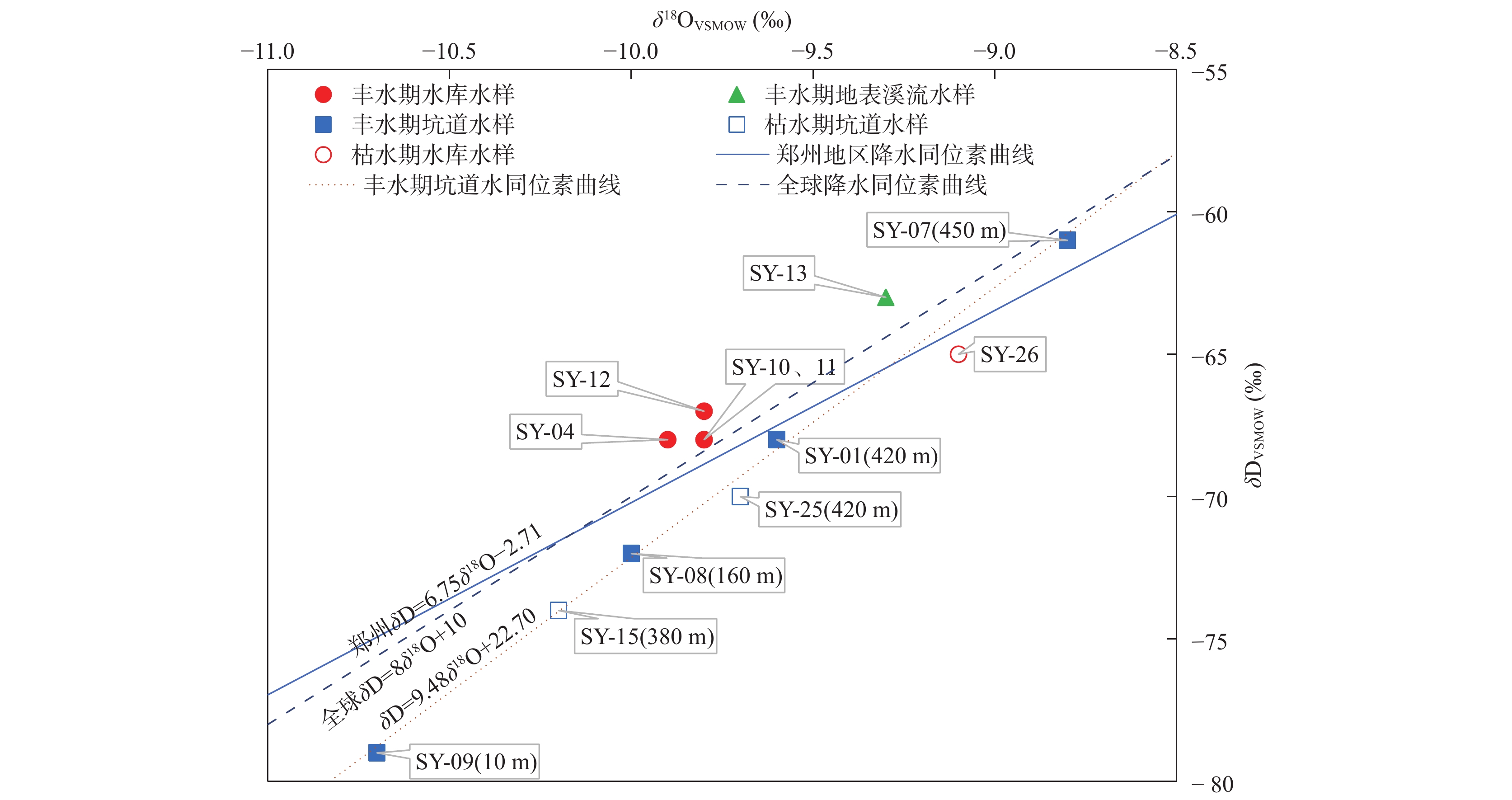
Figure 4.
Water samples in the study area δD and δ18O diagram
-
Figure 5.
Relation curve between shaft water inflow and reservoir water level in October 2021