
| Citation: |
HE Xuezhou, SHU Siqi, CHEN Xiufa, LI Yulong, ZHANG Weibo, WANG Qiushu. 2023. Informatization of international cooperation of China geological survey: Framework, functions and practices. Geological Bulletin of China, 42(12): 2198-2204. doi: 10.12097/j.issn.1671-2552.2023.12.015

|
Informatization of international cooperation of China geological survey: Framework, functions and practices
-
Abstract
With the increasing frequency of international cooperation and exchanges, it is urgent to promote the standardization of international cooperation data, approval process and sharing of results, and to comprehensively improve the capacity of CGS in foreign affairs management, international cooperation, information service and data analysis efficiency.To establish an information-based business system for international cooperation in geological surveys, using geographic information technology, spatial analysis methods and information means such as databases. Designed the international cooperation business data model driven by international cooperation data flow, developed the user interaction interface through the Flex Rich Client technology, and used the Tianditu API interface to realise the international cooperation data model.The user interaction interface was developed using Flex rich client technology, and the Map world API interface was invoked to achieve the spatialization of international cooperation data.After several years of research, development and upgrading, we have finished constructing the information system platform with a three-layer architecture for international cooperation.We have successfully implemented the whole process management of declaration, issuance, execution and remittance of the results for various types of international cooperation visit plans throughout the entire CGS.Based on WebGIS technology to support the visual management of international cooperation accurate information services, the use of mobile communication technology to achieve international cooperation business information reminder and supervision is a brand new attempt of information technology in international cooperation management and services, through the construction of international cooperation business information system, it effectively improves the management and service capacity of international cooperation, and effectively promotes the sharing of international cooperation results of.Through data analysis, it can provide information support and decision-making suggestions for the Bureau's international cooperation management and business development.
-
Keywords:
- international cooperation information technology /
- big data /
- WebGIS /
- Map World /
-

-
References
[1] 冯斌, 梁萌, 吴文鹂. "地质云"模式下大地电磁数据共享研究[J]. 物探与化探, 2020, 44(4): 796-802. [2] 龚薇华, 王晨光, 俞欢军. 基于MVC模式和. NET的公司内部管理信息系统设计[J]. 计算机工程与设计, 2007, 28(9): 2142-2144. doi: 10.3969/j.issn.1000-7024.2007.09.049 [3] 黄凯锋. 基于工作流的高校外事管理系统的研究与设计[D]. 上海交通大学硕士学位论文, 2017. [4] 李仰春, 王永志, 陈圆圆, 等. 智绘地质——新一代智能化地质编图模式及应用[J]. 地质通报, 2020, 39(6): 861-870. [5] 李泽, 李辉, 陈红茜, 等. 基于MVC模式的高校外事信息系统的设计与实现[J]. 电子技术与软件工程, 2014, (7): 225-226. [6] 刘茜茜, 孙亚琴, 吕翔, 等. 基于WebGIS的气象信息服务系统的设计与实现[J]. 计算机工程与设计, 2014, 35(1): 323-326. [7] 吕霞, 刘畅, 邱丽华, 等. 地质调查业务管理信息一体化建设[J]. 国土资源科技管理, 2015, 32(6): 125-130. doi: 10.3969/j.issn.1009-4210.2015.06.018 [8] 马万钟, 杜清运. 地理国情监测的体系框架研究[J]. 国土资源科技管理, 2011, 28(6): 105-111. [9] 宋越, 高振记, 王鹏. 基于大数据技术的云端城市地质三维可视化框架[J]. 中国矿业, 2020, 29(6): 81-86. doi: 10.3969/j.issn.1009-105x.2020.06.008 [10] 孙季震. 企业外事管理系统的设计与实现[D]. 大连理工大学硕士学位论文, 2018. [11] 唐永瑞, 张达敏. 基于Ajax与MVC模式的信息系统的研究与设计[J]. 电子技术应用, 2014, 40(2): 128-131. doi: 10.3969/j.issn.0258-7998.2014.02.040 [12] 谈树成, 金艳珠, 冯龙. 基于RIA的WebGIS斜坡地质灾害气象预报预警信息系统的设计与实现[J]. 地球学报, 2014, 35(1): 119-125. [13] 王瑞玲. RIA及其基于Flex的应用开发模型[J]. 科技情报开发与经济, 2007, 17(14): 206-207. doi: 10.3969/j.issn.1005-6033.2007.14.120 [14] 解蕾, 卢永红, 狄光智. 基于C#/SQL Sever的高校外事管理系统的设计与开发[J]. 山西大同大学学报(自然科学版), 2016, 32(4): 13-15, 50. doi: 10.3969/j.issn.1674-0874.2016.04.006 [15] 徐鸿. 国有企业外事管理信息系统的分析与设计[D]. 云南大学硕士学位论文, 2015. [16] 张华伟. 基于流程平台高校外事信息管理系统的应用[J]. 电子技术与软件工程, 2020, (17): 257-258. [17] 郑啸, 李景朝, 丁克永, 等. 地质资料信息化服务现状、问题与建议[J]. 中国矿业, 2016, 25(S1): 92-94. -
Access History
Figures(4)

Export File
Citation
HE Xuezhou, SHU Siqi, CHEN Xiufa, LI Yulong, ZHANG Weibo, WANG Qiushu. 2023. Informatization of international cooperation of China geological survey: Framework, functions and practices. Geological Bulletin of China, 42(12): 2198-2204. doi: 10.12097/j.issn.1671-2552.2023.12.015
Format
Content
 DownLoad:
-
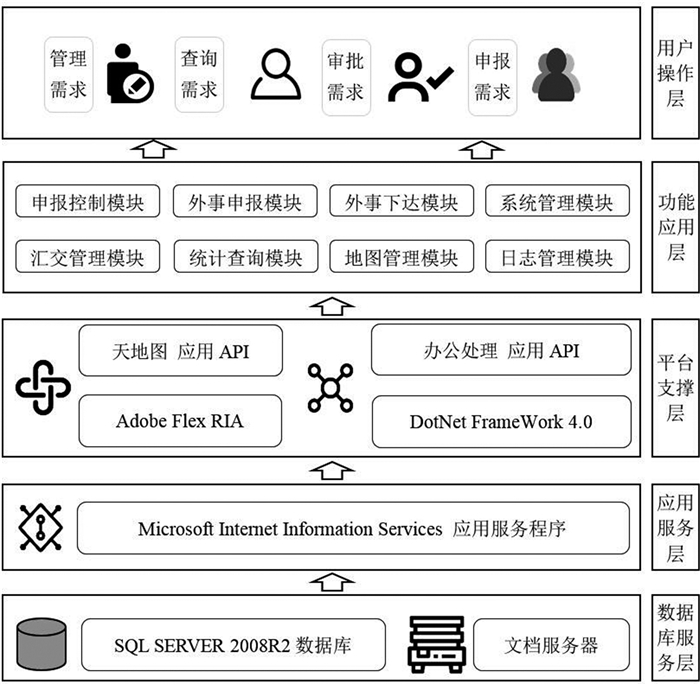
Figure 1.
Architectural of international cooperation information system
-
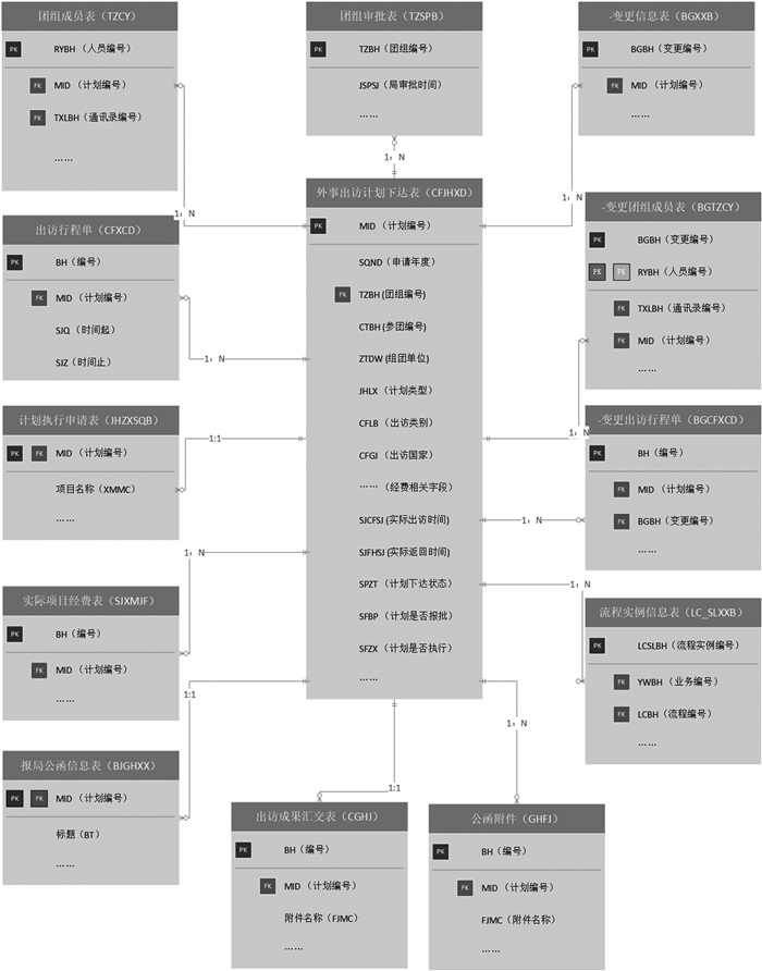
Figure 2.
E-R Chart of database
-
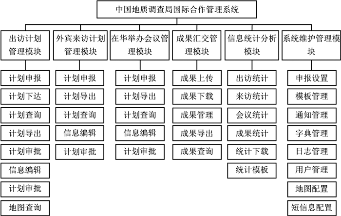
Figure 3.
Functions of system
-
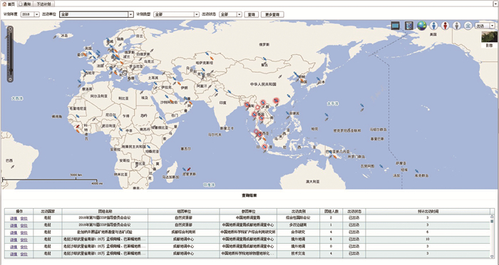
Figure 4.
Visualization for space-based international cooperation data