
| Citation: |
LU Haifeng, CHEN Hailong, YANG Yong, ZHANG Jinzhong. Activities and geomorphic deformation of the fault belt on the southern margin of Wuwei Basin, Gansu Province during the Late Quaternary[J]. Geological Bulletin of China, 2022, 41(2-3): 327-346. doi: 10.12097/j.issn.1671-2552.2022.2-3.012

|
Activities and geomorphic deformation of the fault belt on the southern margin of Wuwei Basin, Gansu Province during the Late Quaternary
-
Abstract
The fault belt on the southern margin of Wuwei Basin is located in the front of the northeastern margin of the Qinghai-Tibet Plateau, and its spacial distribution and activity in the Late Quaternary are still not very clear.In additon, the magnitude 8.0 Gulang eurthquake in 1927 also caused some surface reptures on the fault zone.Based on the principles of tectonic geology and geomorphology and the method of chronological test, the relevant investigation and research were carried out.The results show that the fault belt on the southern margin of the Wuwei Basin extends strikes NWW to SEE in a right-step oblique array.From west to east, the overall behavior of the fault belt during the Late Quaternary was mainly thrusting and gradually transformed to thrusting and strike-slip or strike-slipping.The vertical activity intensity was generally weak in the west and strong in the east.Moreover, middle part exhibited strongest activity, and the horizontal left-lateral slip component was great.Its activity has obvious segmentation, that is, the latest activity of the western section is generally earlier than the regional T1 terrace, and the middle-eastern section cuts the ground of the T1 terrace, which reflects the trend of eastward migration of its latest activity.Combined with the surface rupture relics caused by the 1927 M8.0 Gulang earthquake, the latest activity in its middle-eastern section occurred at the end of the Holocene.According to the Late Quaternary activity pattern of the fault belt, face scratches, the kinematic characteristics of shear joints developed in the Late Cenozoic strata, and conjugate tension joints, the horizontal direction of the maximum principal compressive stress field during the late Quaternary was the NNE-SSW, and the orientation of the stress field changed slightly from west to east.These insights provide important basis for exploring the Late Cenozoic tectonic evolution of the three-dimensional deformation of Wuwei Basin, the strata growth and tectonic geomorphic deformation process in the northeastern margin of the Qinghai-Tibet Plateau, the rupture mechanism of the Gulang earthquake, and climate and environment changes.
-

-
References
[1] 刘峡, 黄立人, 杨国华, 等. 北祁连—河西走廊地区垂直形变与构造应力场关系的初步研究———三维有限元拟合结果分析[J]. 地震地质, 2003, 25(2): 307-316. doi: 10.3969/j.issn.0253-4967.2003.02.016 [2] 艾晟, 张波, 樊春, 等. 武威盆地南缘断裂晚第四纪活动地表形迹与活动速率[J]. 地震地质, 2017, 39(2): 408-422. doi: 10.3969/j.issn.0253-4967.2017.02.010 [3] 刘飞, 李有利, 雷惊昊, 等. 青藏高原东北缘永昌南山北麓洪积扇对气候变化与构造运动的响应[J]. 海洋地质与第四纪地质, 2019, 39(4): 163-173. [4] 蔡厚维. 试谈河西走廊的新构造运动[J]. 甘肃地质, 1986, 6: 95-102. [5] Tapponnier P, Xu Z Q, Roger F, et al. Oblique stepwise rise and growth of the Tibet Plateau[J]. Science, 2001, 294(5547): 1671-1677. doi: 10.1126/science.105978 [6] Zhang P Z, Shen Z K, Wang M. Continuous deformation of the Tibetan Plateau from global positioning system data[J]. Geology, 2004, 32: 809-812. [7] 陈文彬. 河西走廊及邻近地区最新构造变形基本特征及构造成因分析[D]. 中国地震局地质研究所博士学位论文, 2003. [8] 郑文涛, 杨景春, 段锋军. 武威盆地晚更新世河流阶地变形与新构造活动[J]. 地震地质, 2000, 22(3): 318-328. doi: 10.3969/j.issn.0253-4967.2000.03.012 [9] 胡小飞, 潘保田, 高红山, 等. 祁连山东段全新世河流阶地发育及其与气候变化的关系研究[J]. 第四纪研究, 2013, 33(4): 723-736. doi: 10.3969/j.issn.1001-7410.2013.04.10 [10] 国家地震局地质研究所, 国家地震局兰州地震研究所. 祁连山-河西走廊活动断裂系[M]. 北京: 地震出版社, 1993. [11] 陈永明, 刘洪春, 曾文浩, 等. 古浪大震的地质灾害及破坏特征[J]. 西北地震学报, 1999, 21(3): 315-320. [12] 郑文俊. 河西走廊及其邻区活动构造图像及构造变形模式[D]. 中国地震局地质研究所博士学位论文, 2009. [13] 胡小飞. 祁连山北部侵蚀速率的时空分布与构造抬升变形研究[D]. 兰州大学博士学位论文, 2010. [14] 侯康明, 石亚缪, 张忻. 青藏高原北部NNW向构造活动方式及形成年代[J]. 地震地质, 1999, 21(2): 127-136. doi: 10.3969/j.issn.0253-4967.1999.02.005 [15] 苏琦, 袁道阳, 谢虹. 祁连山东段石羊河流域及邻区地貌特征及其构造意义[J]. 地质论评, 2017, 63(1): 7-20. [16] Champagnac J D, Yuan D M, Ge W P, et al. Slip rate at the north-eastern front of the Qianlian Shan, China[J]. Terra Nova, 2010, 22: 180-187. doi: 10.1111/j.1365-3121.2010.00932.x [17] Pan B T, Hu X F, Gao H S, et al. Late Quaternary river incision rates and rock uplift pattern of the eastern Qilian Shan Mountain, China[J]. Geomorphology, 2013, 184 (430): 84-97. [18] Guo P, Han Z J, Gao F, et al. A new tectonic model for the 1927 M8.0 Gulang earthquake on the NE Tibetan Plateau[J]. Tectonics, 2020, 39(9), https://DOI.ORG/10.1029/2020TC006064. doi: 10.1029/2020TC006064 [19] 地信网. 中国历史地震目录数据[EB/OL]. [2020-10-08]http://bbs.3s001.com/thread-276444-1-1.htm. [20] 刘昌森, 火恩杰, 王锋. 中国地震历史资料拾遗[M]. 北京: 地震出版社, 2003: 1-167. [21] 车福东, 王涛, 辛鹏, 等. 近远震作用下黄土滑坡动力响应与变形——以甘肃天水震区黎坪村滑坡为例[J]. 地质通报, 2020, 39(12): 1981-1992. [22] 卢海峰, 张世民, 马保起, 等. 汶川Ms8.0地震断层映秀—南坝段的活动方式、形变特征及其形成机制[J]. 地球物理学报, 2009, 52(5): 1376-1383. doi: 10.3969/j.issn.0001-5733.2009.05.027 [23] 徐锡伟, 陈桂华, 于贵华, 等. 5 · 12汶川地震地表破裂基本参数的再论证及其构造内涵分析[J]. 地球物理学报, 2010, 53(10): 2321-2336. doi: 10.3969/j.issn.0001-5733.2010.10.006 [24] 徐纪人. 河西走廊地区区域应力场的研究[J]. 西北地震学报, 1990, 12(4): 88-92. [25] 李步云, 王连权. 祁连山—河西走廊地区断裂活动性评价[J]. 高原地震, 1999, 11(1): 32-36. [26] Gaudemer Y, Tapponnier P, Meyer B, et al. Partitioning of crustal slip between linked, active faults in the eastern Qilian Shan, and evidence for a major seismic gap, the"Tianzhu gap", on the western Haiyuan Fault, Gansu(China)[J]. Geophysical Journal International, 1995, 120(3): 599-645. doi: 10.1111/j.1365-246X.1995.tb01842.x -
Access History

Figures(11)
Tables(2)

Export File
Citation
LU Haifeng, CHEN Hailong, YANG Yong, ZHANG Jinzhong. Activities and geomorphic deformation of the fault belt on the southern margin of Wuwei Basin, Gansu Province during the Late Quaternary[J]. Geological Bulletin of China, 2022, 41(2-3): 327-346. doi: 10.12097/j.issn.1671-2552.2022.2-3.012
Format
Content
 DownLoad:


-
Figure 1.
Geological environment and distribution of faults on the southern margin of Wuwei Basin
-
Figure 2.
Deformation characteristics of structural geomorphology on the west side of Xiying River
-
Figure 3.
Structural deformation of the southern Chenjiayangou village
-
Figure 图版Ⅰ.
-
Figure 4.
Structural deformation of the fault segment F5-4
-
Figure 图版Ⅱ.
-
Figure 5.
Fault profile developed in the east side of a gully with the north-south direction, 3 km to the southern Lijiawan village
-
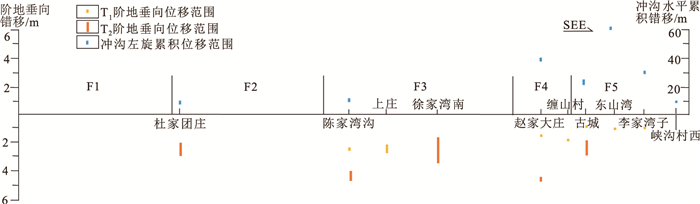
Figure 6.
Dislocation amount of the fault during the Late Quaternary
-
Figure 7.
Multi-period activities of the fault belt and nearby ancient landslide
-
Figure 8.
Earthquake surface rupture developed on the south of the Liujiaxiaozhaiwan village
-
Figure 9.
Characteristics of the regional tectonic stress field in the study area