

| Citation: |
SUN Yuqing, GE Yonggang, CHEN Xingzhang, ZENG Lu, LIANG Xinyue, FENG Xin. 2025. Hazard assessment of debris flow in Jinsha River. Geological Bulletin of China, 44(2~3): 377-391. doi: 10.12097/gbc.2023.08.008

|
Hazard assessment of debris flow in Jinsha River
-
Abstract
Objective This study investigates the distribution characteristics of debris flow in Jinsha River and conducts a hazard assessment to provide data support and a scientific basis for understanding regional variations in debris flow and disaster prevention in the Hengduan Mountain area.
Methods Based on the field investigation and GIS spatial analysis, 2551 debris flows in the Jinsha River were identified. Hazard assessment was performed based on the activity characteristics of these debris flows. Using ROC analysis and spatial clustering, the debris flow hazard zoning in the Jinsha River was established.
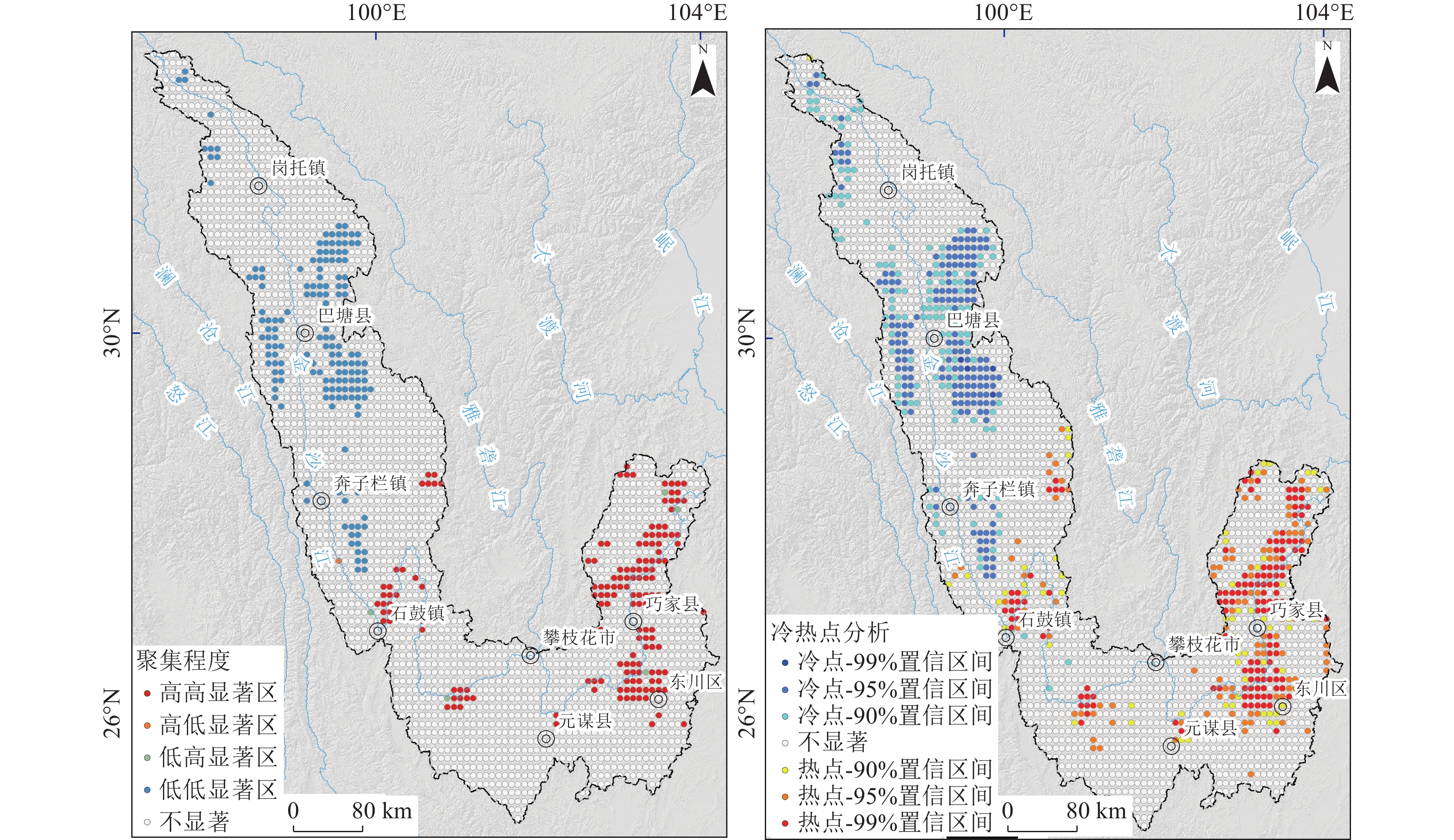
Results ① Debris flows in the upper reaches of Jinsha River are not active, predominantly of low to medium frequency, while high−frequency debris flows are concentrated in the lower reaches, especially between Yarmou and Qiaojia. ② The primary factors influencing debris flow formation include slopes ranging from 15° to 35°, frequent seismic activity, and the presence of both soft and hard clastic rocks. ③ Medium− and high−hazard debris flows cover 47.48% of the area, nearly half of the studied region. ④ The high−hazard zone in the Dongchuan−Qiaojia section shows high concentration, closely correlating with active faults and abundant sediment supply, largely controlled by tectonic activity.
Conclusions High−hazard debris flow zones are concentrated in the downstream of Jinsha River. The hazard zoning map provides a reference for risk mitigation in hydropower development and transportation infrastructure planning.
-
Keywords:
- debris flow /
- hazard /
- activity characteristics /
- Jinsha River
-

-
References
[1] Agterberg F A. 2011. Modified Weights−of−Evidence Method for Regional Mineral Resource Estimation[J]. Natural Resources Research, 20(2): 95−101. doi: 10.1007/s11053-011-9138-0 [2] Akbar T A, Ha S R. 2011. Landslide hazard zoning along Himalayan Kaghan Valley of Pakistan−by integration of GPS, GIS, and remote sensing technology[J]. Landslides, 8(4): 527−540. doi: 10.1007/s10346-011-0260-1 [3] Berenguer M, Sempere−Torres D, Hürlimann M. 2014. Debris−flow hazard assessment at regional scale by combining susceptibility mapping and radar rainfall[J]. Natural Hazards and Earth System Sciences, 2(10): 6295−6338. [4] Bi X, Fan Q, He L, et al. 2023. Analysis and Evaluation of Extreme Rainfall Trends and Geological Hazards Risk in the Lower Jinshajiang River[J]. Applied Sciences, 13(6): 4021. doi: 10.3390/app13064021 [5] Blothe J H, Korup O, Schwanghart W. 2015. Large landslides lie low: Excess topography in the Himalaya−Karakoram ranges[J]. Geology, 43(6): 523−526. doi: 10.1130/G36527.1 [6] Bojer A K, Ahmed M E, Bekalo D J, et al. 2023. Analysis of land use/land cover change (LULCC) and debris flow risks in Adama district, Ethiopia, aided by numerical simulation and deep learning−based remote sensing[J]. Stochastic Environmental Research and Risk Assessment, 37: 4893−4910. doi: 10.1007/s00477-023-02550-w [7] Bregoli F, Medina V, Chevalier G. et al. 2015. Debris−flow susceptibility assessment at regional scale: Validation on an alpine environment[J]. Landslides, 12(3): 437−454. doi: 10.1007/s10346-014-0493-x [8] Cabral V, Reis F, Veloso V, et al. 2023. A multi−step hazard assessment for debris−flow prone areas influenced by hydroclimatic events[J]. Engineering Geology, 313: 106961. doi: 10.1016/j.enggeo.2022.106961 [9] Cao P, Li Y, Li Z, et al. 2021. Geological structure characteristics and genetic mechanism of Baige Landslide Slope in Changdu Tibet[J]. Earth Science, 46(9): 3397−3409 (in Chinese with English abstract). [10] Chang M, Tang C, Van Asch T W J, et al. 2017. Hazard assessment of debris flows in the Wenchuan earthquake−stricken area, South West China[J]. Landslides, 14(5): 1783−1792. doi: 10.1007/s10346-017-0824-9 [11] Chen C, Tseng C, Dong J. 2007. New entropy−based method for variables selection and its application to the debris−flow hazard assessment[J]. Engineering Geology, 94(1/2): 19−26. doi: 10.1016/j.enggeo.2007.06.004 [12] Chen J, Li Y, Xu C. 2016. Susceptibility assessment model of debris flows in the dry−hot valley of the Jinsha River and its application[J]. Mountain Research, 34(4): 460−467 (in Chinese with English abstract). [13] Chen X, Chen H, You Y, et al. 2016. Weights−of−evidence method based on GIS for assessing susceptibility to debris flows in Kangding County, Sichuan Province, China[J]. Environmental Earth Sciences, 75(1): 70. doi: 10.1007/s12665-015-5033-z [14] Esper Angillieri, M Y. 2020. Debris flow susceptibility mapping using frequency ratio and seed cells, in a portion of a mountain international route, Dry Central Andes of Argentina[J]. Catena, 189: 104504. doi: 10.1016/j.catena.2020.104504 [15] Fawcett T. 2006. An introduction to ROC analysis[J]. Pattern Recognition Letters, 27(8): 861−874. doi: 10.1016/j.patrec.2005.10.010 [16] Feng Z, Chen L, Wang L C, et al. 2024. Principle and application of the weight−of−evidence method in regional landslide susceptibility assessment[J]. Geological Bulletin of China, 43(7): 1255−1265 (in Chinese with English abstract). [17] Hu G, Tian S, Chen N, et al. 2020. An effectiveness evaluation method for debris flow control engineering for cascading hydropower stations along the Jinsha River, China[J]. Engineering Geology, 266: 105472. doi: 10.1016/j.enggeo.2019.105472 [18] Kuo Y, Yang T, Huang G. 2008. The use of grey relational analysis in solving multiple attribute decision−making problems[J]. Computers & Industrial Engineering, 55(1): 80−93. [19] Li Y, Chen J, Zhou F, et al. 2020. Identification of ancient river−blocking events and analysis of the mechanisms for the formation of landslide dams in the Suwalong section of the upper Jinsha River, SE Tibetan Plateau[J]. Geomorphology, 368: 107351. doi: 10.1016/j.geomorph.2020.107351 [20] Li Y, Su L, Zou Q, et al. 2021. Risk assessment of glacial debris flow on alpine highway under climate change: A case study of Aierkuran Gully along Karakoram Highway[J]. Journal of Mountain Science, 18(6): 1458−1475. doi: 10.1007/s11629-021-6689-3 [21] Liu X, Dong X, Qian J, et al. 2024. Airborne LiDAR−based Debris Flow Material Sources Remote Sensing Recognition in Lush Mountainous Area[J]. Geomatics and Information Science of Wuhan University, 49(3): 400−410 (in Chinese with English abstract). [22] Liu X, Yao X, Yu K, et al. 2020. Remote sensing integrated identification of geological hazards in the Batang−Mangkang Section of the Sichuan−Tibet Highway[J]. Advanced Engineering Sciences, 52(6): 49−60 (in Chinese with English abstract). [23] Liu Z, Xu L, Jiang H. 2018. Study on the review of the risk assessment of debris flow, 2nd International Workshop on Renewable Energy and Development (IWRED)[J]. IOP Conference Series−Earth and Environmental Science, 153: 062083. doi: 10.1088/1755-1315/153/6/062083 [24] Lou Y, Xu S, Wu X. 2007. Geological disaster development mechanism and their prevention countermeasures in the "Three Rivers" juxtaposition area, Yunnan Province[J]. The Chinese Journal of Geological Hazard and Control, 4: 1−6 (in Chinese with English abstract). [25] Lou Y. 2009. Research on Geologic Environment in Three Parallel Rivers Region [D]. PhD Dissertation of China University of Geosciences (Beijing) (in Chinese with English abstract). [26] Lyu L, Xu M, Wang Z, et al. 2022. A field investigation on debris flows in the incised Tongde sedimentary basin on the northeastern edge of the Tibetan Plateau[J]. Catena, 208: 105727. doi: 10.1016/j.catena.2021.105727 [27] Ming Q, Pan Y. 2002. The elementary acknowledge on the importance of environmental evolution of Yunnan Plateau[J]. Journal of Geomechanics, 8(4): 361−368 (in Chinese with English abstract). [28] Ming Q. 2006. The landform development and environment effects of three parallel rivers in the north of Longitudinal Range−Gorge Region (LRGR) [D]. PhD Dissertation of Lanzhou University (in Chinese with English abstract). [29] Morel M, Piton G, Kuss D, et al. 2023. Statistical modeling of sediment supply in torrent catchments of the northern French Alps[J]. Natural Hazards and Earth System Sciences, 23(5): 1769−1787. doi: 10.5194/nhess-23-1769-2023 [30] Pan G, Wang L, Li R, et al. 2012. Tectonic evolution of the Qinghai−Tibet Plateau[J]. Journal of Asian Earth Sciences, 53: 3−14. doi: 10.1016/j.jseaes.2011.12.018 [31] Peng S, Ding D, Liu W, et al. 2019. 1 km monthly temperature and precipitation dataset for China from 1901 to 2017[J]. Earth System Science Data, 11: 1931−1946. doi: 10.5194/essd-11-1931-2019 [32] Saaty T. 1990. Multicriteria Decision Making: The Analytic Hierarchy Process[M]. Springer Netherlands. [33] Wang B, Wang L, Wang D, et al. 2021. The temporal and spatial framework and its tectonic evolution of the Jinsha River arc−basin system, Southwest China[J]. Sedimentary Geology and Tethyan Geology, 41(2): 246−264 (in Chinese with English abstract). [34] Wang N, Pu K. 2018. Grey Relational Analysis of geological hazards and urbanization construction in China[J]. IOP Conference Series: Materials Science and Engineering, 381(1): 012012. [35] Wen H J, Hu J W, Zhang H, et al. 2024. Debris flow accumulation area using modified Laharz model[J]. Journal of Jilin University(Earth Science Edition), 54(3): 905−918 (in Chinese with English abstract). [36] Wu S, Chen J, Wendy Z, et al. 2018. Debris−flow susceptibility assessment and validation based on logistic Regression model: an example from the Benzilan−Changbo segment of the upper Jinshajiang River[J]. Geoscience, 32(3): 611−622 (in Chinese with English abstract). [37] Xiang L, Li Y, Chen H, et al. 2015. Sensitivity analysis of debris flow along highway based on geomorphic evolution theory[J]. Resources and Environment in the Yangtze Basin, 24(11): 1984−1992 (in Chinese with English abstract). [38] Xue X, Zheng L. 2013. GIS−information method based risk evaluation for debris flow in Chencang District, International Conference on Advances in Energy and Environmental Science[J]. Advanced Materials Research, 807/809: 1928−1933. doi: 10.4028/www.scientific.net/AMR.807-809.1928 [39] Yin C, Zhang J. 2018. Hazard regionalization of debris−flow disasters along highways in China[J]. Natural Hazards, 91(S1): 129−147. doi: 10.1007/s11069-018-3229-8 [40] Zeng C, Cao Z, Su F, et al. 2022. A dataset of high−precision aerial imagery and interpretation of landslide and debris flow disaster in Sichuan and surrounding areas between 2008 and 2020[J]. China Scientific Data, 7(2): 195−205 (in Chinese with English abstract). [41] Zhang C, Wang Q, Chen J, et al. 2011. Evaluation of debris flow risk in Jinsha River based on combined weight process[J]. Rock and Soil Mechanics, 32(3): 831−836 (in Chinese with English abstract). [42] Zhang J, Tian S, Hou P. 2021. The material supply ability analysis of debris flows based on areahypsometric integral and area−gradient integral[J]. The Chinese Journal of Geological Hazard and Control, 32(4): 9−16 (in Chinese with English abstract). [43] Zhang Y, Gao Y, Li B, et al. 2023. Characteristics and geological hazards of melange belts in Qinghai−Tibet Plateau[J]. Journal of Engineering Geology, 31(3): 981−998 (in Chinese with English abstract). [44] 曹鹏, 黎应书, 李宗亮, 等. 2021. 西藏昌都白格滑坡斜坡地质结构特征及成因机制[J]. 地球科学, 46(9): 3397−3409. [45] 陈剑, 黎艳, 许冲. 2016. 金沙江干热河谷区泥石流易发性评价模型及应用[J]. 山地学报, 34(4): 460−467. [46] 冯振, 陈亮, 王立朝, 等. 2024. 区域地质灾害易发性评价的证据权法原理与实践[J]. 地质通报, 43(7): 1255−1265. doi: 10.12097/gbc.2023.02.034 [47] 骆银辉. 2009. 三江并流区地质环境问题研究[D]. 中国地质大学(北京)博士学位论文. [48] 骆银辉, 徐世光, 吴香根. 2007. 云南“三江”并流区地质灾害发育机制及其防治[J]. 中国地质灾害与防治学报, 4: 1−6. doi: 10.3969/j.issn.1003-8035.2007.03.001 [49] 刘小莎, 董秀军, 钱济人, 等. 2024. 高植被山区泥石流物源LiDAR遥感精细识别方法研究[J]. 武汉大学学报(信息科学版), 49(3): 400−410. [50] 刘星洪, 姚鑫, 於开炳, 等. 2020. 川藏高速巴塘-芒康段地质灾害遥感综合早期识别研究[J]. 工程科学与技术, 52(6): 49−60. [51] 明庆忠. 2006. 纵向岭谷北部三江并流区河谷地貌发育及其环境效应研究[D]. 兰州大学博士学位论文. [52] 明庆忠, 潘玉君. 2002. 对云南高原环境演化研究的重要性及环境演变的初步认知[J]. 地质力学学报, 8(4): 361−368. doi: 10.3969/j.issn.1006-6616.2002.04.011 [53] 王保弟, 王立全, 王冬兵, 等. 2021. 西南三江金沙江弧盆系时空结构及构造演化[J]. 沉积与特提斯地质, 41(2): 246−264. [54] 文海家, 胡吉威, 张辉, 等. 2024. 泥石流危险范围Laharz修正模型及其应用[J]. 吉林大学学报(地球科学版), 54(3): 905−918. [55] 吴赛儿, 陈剑, Wendy Z, 等. 2018. 基于逻辑回归模型的泥石流易发性评价与检验: 以金沙江上游奔子栏-昌波河段为例[J]. 现代地质, 32(3): 611−622. [56] 向灵芝, 李泳, 陈洪凯, 等. 2015. 基于流域演化的泥石流敏感性分析[J]. 长江流域资源与环境, 24(11): 1984−1992. doi: 10.11870/cjlyzyyhj201511024 [57] 曾超, 曹振宇, 苏凤环, 等. 2022. 四川及周边滑坡泥石流灾害高精度航空影像及解译数据集(2008—2020年)[J]. 中国科学数据, 7(2): 195−205. [58] 张晨, 王清, 陈剑平, 等. 2011. 金沙江流域泥石流的组合赋权法危险度评价[J]. 岩土力学, 32(3): 831−836. doi: 10.3969/j.issn.1000-7598.2011.03.032 [59] 张静, 田述军, 侯鹏鹂. 2021. 基于面积-高程和面积-坡度积分的泥石流物质供给能力分析[J]. 中国地质灾害与防治学报, 32(4): 9−16. [60] 张彦锋, 高杨, 李滨, 等. 2023. 青藏高原混杂岩带及其地质灾害发育特征分析[J]. 工程地质学报, 31(3): 981−998. [61] 中华人民共和国地质矿产行业标准. 2015. 滑坡崩塌泥石流灾害调查规范(1∶50000):D2/T 0261—2014[S]. 中国标准出版社. -
Access History
Figures(9)
Tables(4)

Export File
Citation
SUN Yuqing, GE Yonggang, CHEN Xingzhang, ZENG Lu, LIANG Xinyue, FENG Xin. 2025. Hazard assessment of debris flow in Jinsha River. Geological Bulletin of China, 44(2~3): 377-391. doi: 10.12097/gbc.2023.08.008
Format
Content
 DownLoad:


-
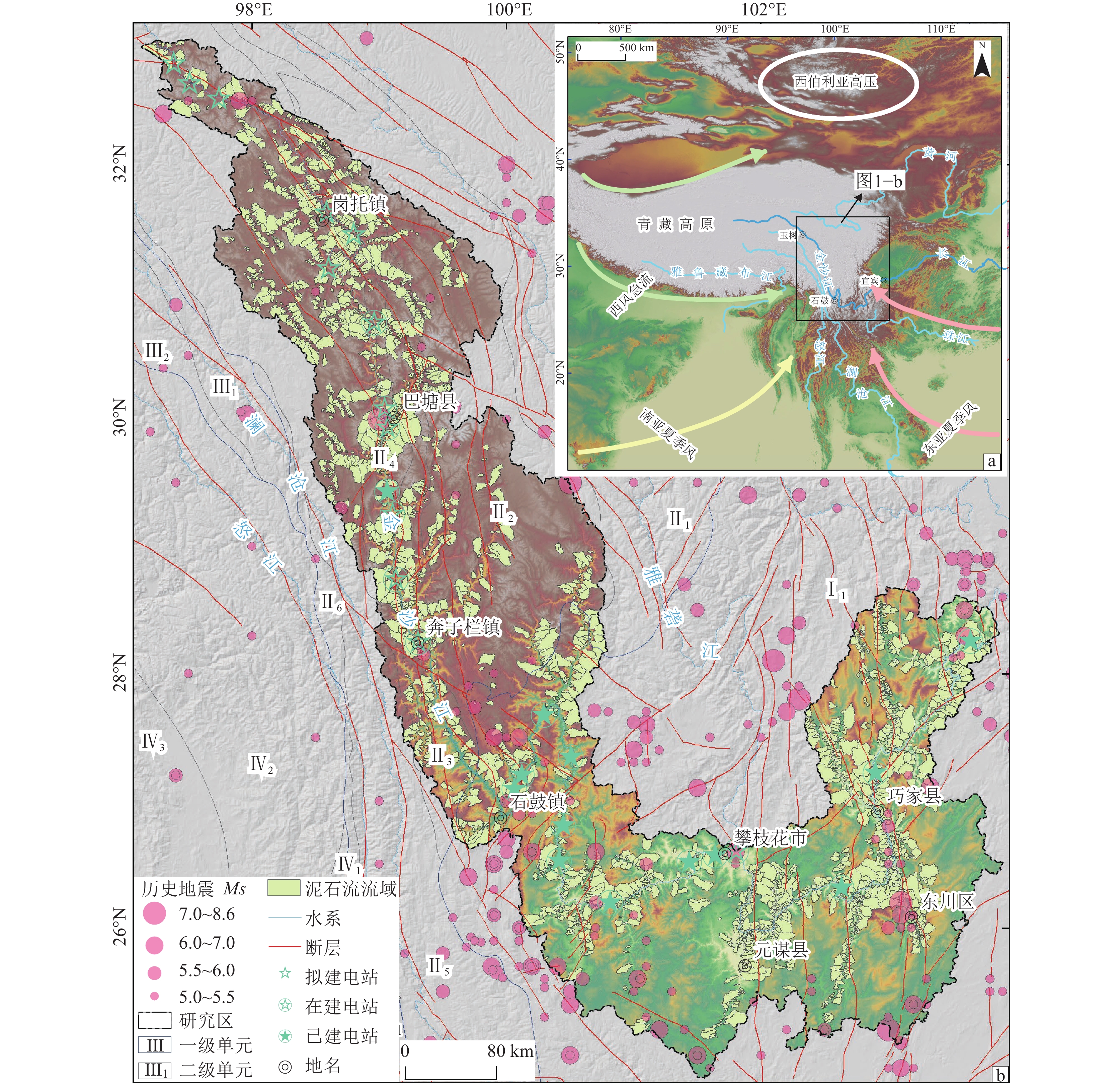
Figure 1.
Regional background map of Jinsha River
-
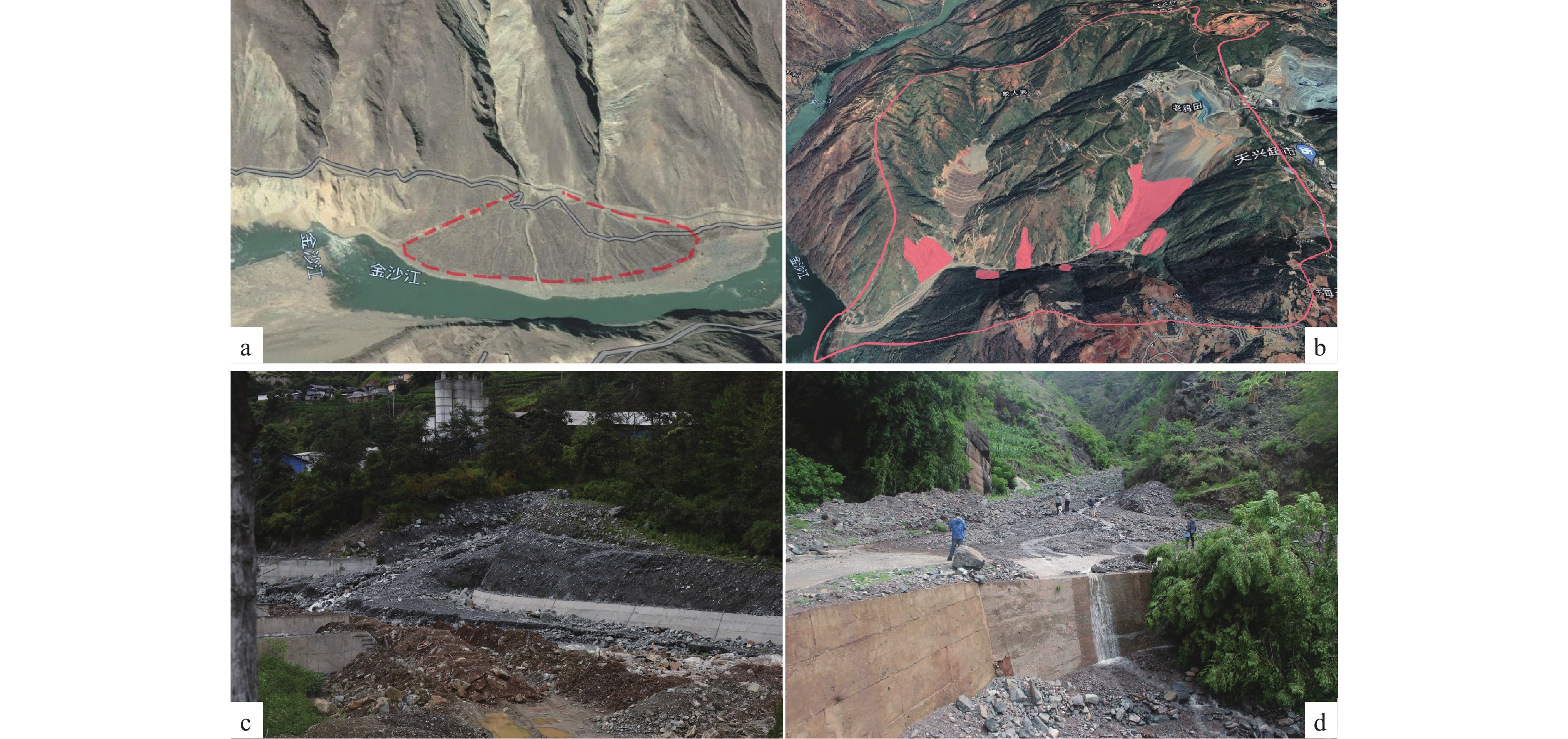
Figure 2.
Remote sensing images (a, b) and field photos (c, d) of typical debris flows
-
Figure 3.
Distribution of different types of debris flow in Jinsha River Basin
-
Figure 4.
Distribution of debris flow hazard assessment indicators in Jinsha River
-
Figure 5.
Statistical diagrams of debris flow index classification in Jinsha River
-
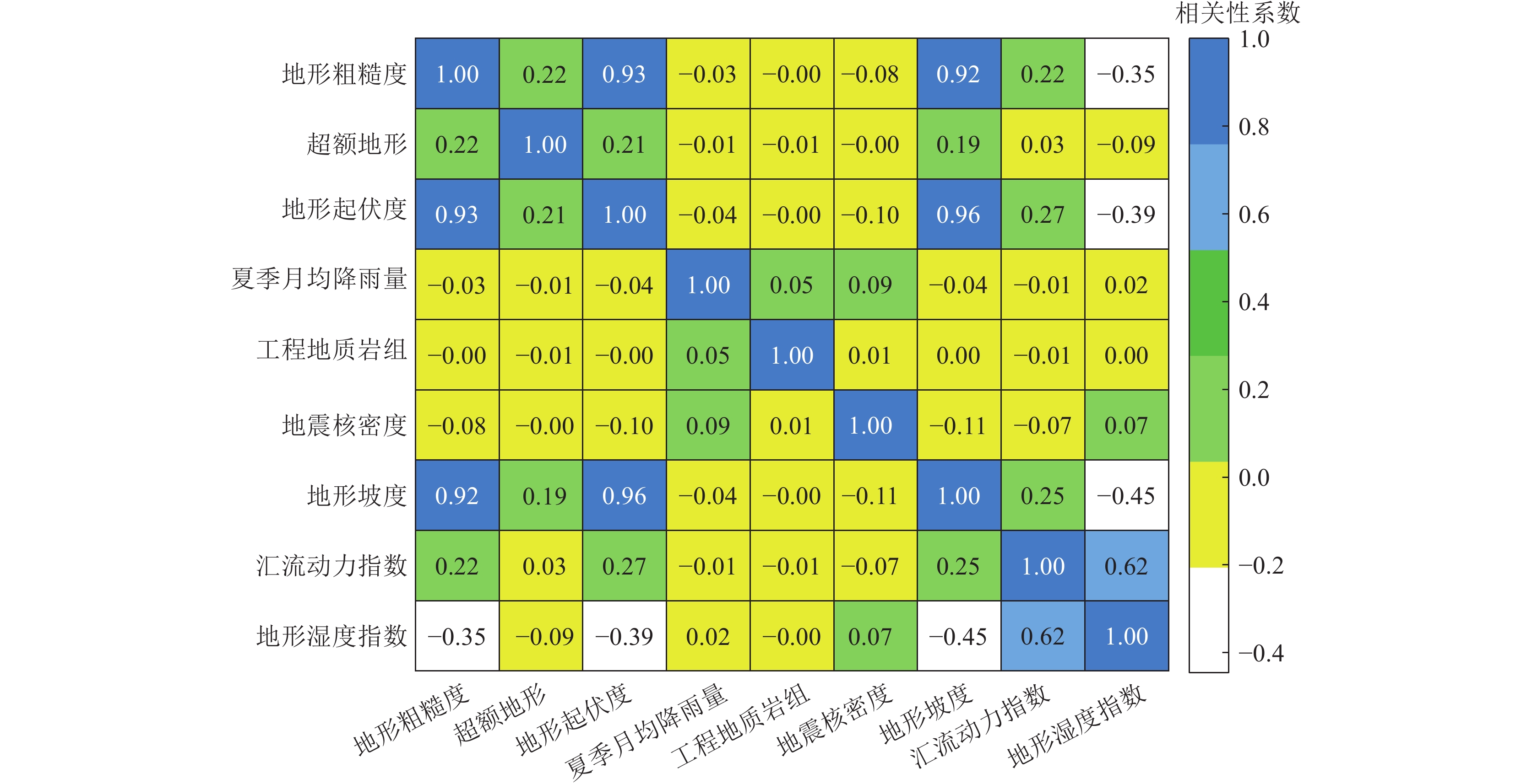
Figure 6.
Correlation analysis of debris flow hazard assessment indicators in Jinsha River
-
Figure 7.
Debris flow hazard assessment zoning map of Jinsha River
-
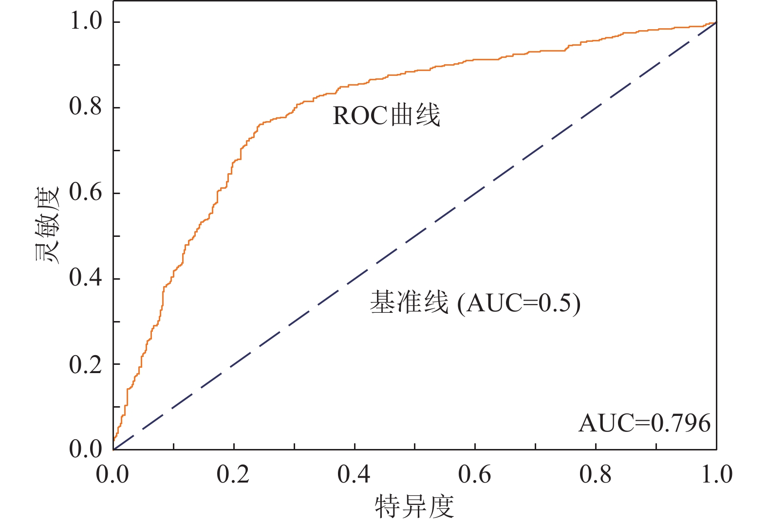
Figure 8.
ROC test results of debris flow hazard assessment in Jinsha River
-
Figure 9.
Cluster analysis of debris flow hazard assessment results in Jinsha River