
| Institute of Geomechanics, Chinese Academy of Geological Sciences | Host |
| Citation: |
ZHANG Jianyu, LYU Dunyu, LIU Songbo, WANG Cuiling, MENG Shuran. 2024. Development characteristics and risk assessment of geological hazards in the mountainous and hilly areas of western Zhengzhou City. Journal of Geomechanics, 30(4): 647-658. doi: 10.12090/j.issn.1006-6616.2022116

|
Development characteristics and risk assessment of geological hazards in the mountainous and hilly areas of western Zhengzhou City
-
Abstract
Objective The mountainous and hilly areas of western Zhengzhou City have a complex geological environment, affected by rainfall and human engineering activities. Geological hazards such as collapses, landslides, and debris flows occur frequently. In particular, the “7·20” extreme rainstorm that occurred on July 20, 2021 caused many geological hazards, resulting in heavy casualties and huge economic losses. Therefore, analyzing and summarizing the development characteristics of geological hazards and conducting a risk assessment is necessary for this region. At present, the risk assessment of geological hazards is mainly conducted using a single method that has limitations including slightly low evaluation accuracy. In addition, an overall geological hazard risk assessment has not yet been conducted in the mountainous and hilly areas of western Zhengzhou City.
Methods Based on the research and analysis of the geological environment background and the distribution characteristics of geological hazards in the study area, eight evaluation factors were selected: slope, landform, engineering geological rock group, elevation, distance from fault, distance from river, rainfall, and human engineering activities. The weighted information method which incorporates elements of the information quantity model and analytic hierarchy process, was used to evaluate the risk of geological hazards in the study area.
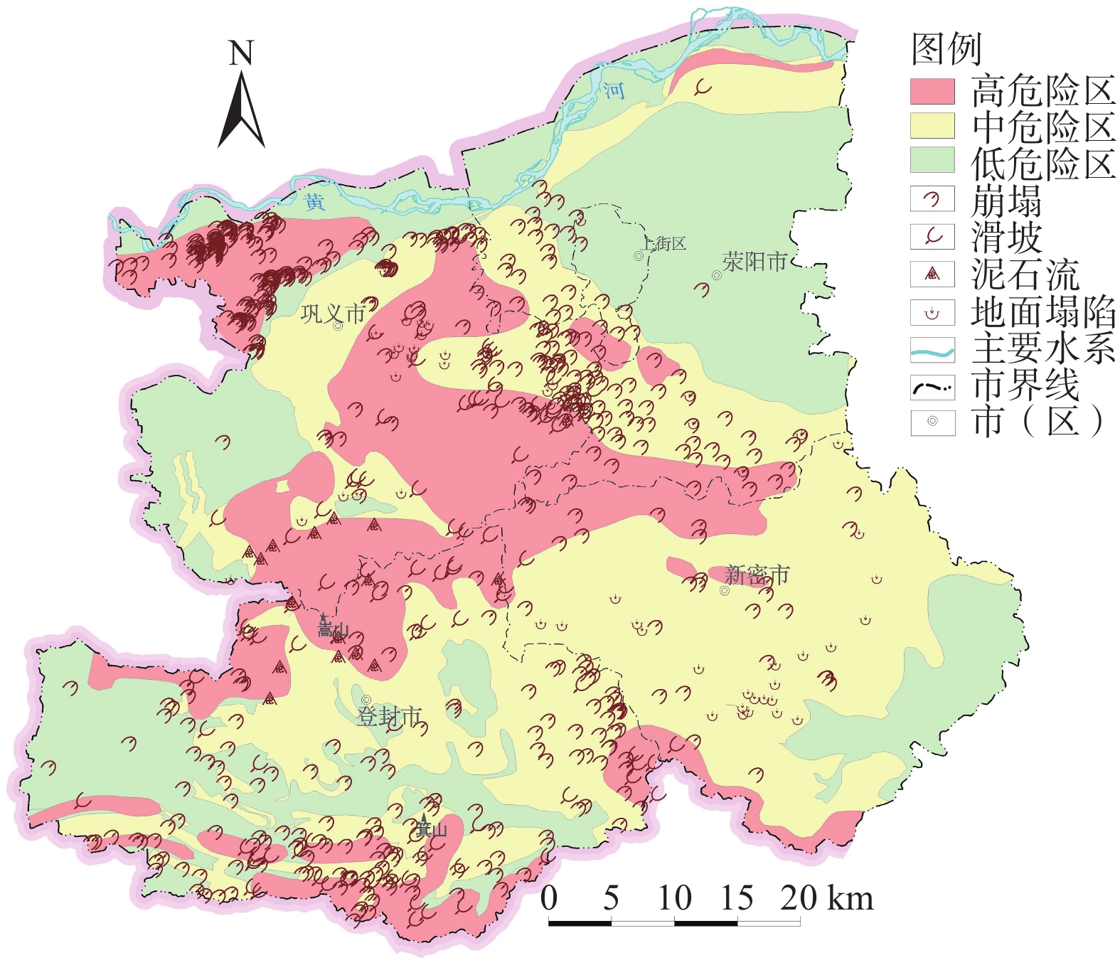
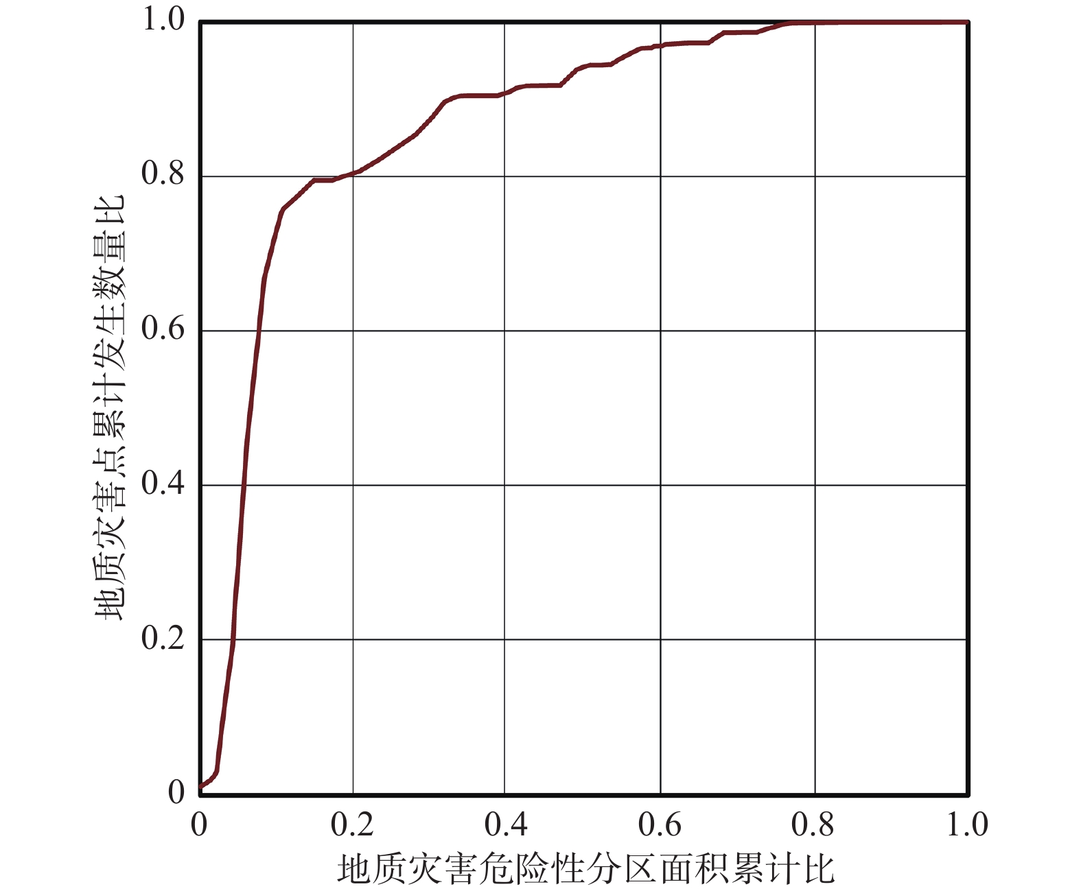
Results The low-, medium-, and high-risk areas are 1387.14 km2, 1803.18 km2, and 1066.47 km2, respectively, accounting for 32.59%, 42.36%, and 25.05% of the total area, respectively. The medium- and high-risk areas are mainly distributed in the tectonic erosion medium-low mountains and loess hills in the central part of the four cities, the tectonic erosion medium-low mountains south of Dengfeng, and the loess hilly areas in northern Gongyi and Xingyang. The terrain has steep slopes and deep gullies, and the main stratigraphic lithology is clastic rocks intercalated with carbonate rocks, soft and hard rock layers, and loess. Fault structures are developed, and geological hazards are prone to occur under the action of inducing factors and are highly dangerous. The majority (93.11%) of geological hazards are distributed in medium- and high-risk areas, with hazard point densities of 0.1752 km−2 and 0.2869 km−2, respectively. The spatial distribution of geological hazard points is consistent with the geological hazard risk assessment results. The rationality of the evaluation results was assessed by a Receiver Operating Characteristic curve, yielding an AUC value of 0.868. The evaluation accuracy met the requirements for hazard assessment.
Conclusion Geological hazards have the largest information value in the range of >40° slopes loess hilly landforms, loess engineering geological rock groups, and 24-h maximum rainfall of 500–550 mm. The risk of geological hazards is positively correlated with distance from faults and water systems — the closer the distance, the higher the risk. The risk of geological disasters in the study area is controlled by the terrain slope and landform and is closely related to the lithology of the formation, which is an important factor in inducing geological disasters. The weighted information method, which has high accuracy and rationality, was used to evaluate the geological hazard risk.
Significance The results of this study can provide a basis and technical support for geological hazard prevention and management in the mountainous and hilly areas of western Zhengzhou City and serve as a valuable point of reference for urban planning and infrastructure geological hazard risk assessment in the study area.
-

-
References
[1] ALI S, BIERMANNS P, HAIDER R, et al., 2019. Landslide susceptibility mapping by using a geographic information system (GIS) along the China-Pakistan Economic Corridor (Karakoram Highway), Pakistan[J]. Natural Hazards and Earth System Sciences, 19(5): 999-1022. doi: 10.5194/nhess-19-999-2019 [2] CHEN G Y, WANG L, JIAO H J, et al. , 2009. Environmental geological survey and evaluation report of major cities in Henan Province (Zhengzhou City)[R]. Zhengzhou: Henan Geological Survey Institute. (in Chinese) [3] CLERICI A, PEREGO S, TELLINI C, et al., 2002. A procedure for landslide susceptibility zonation by the conditional analysis method[J]. Geomorphology, 48(4): 349-364. doi: 10.1016/S0169-555X(02)00079-X [4] DENG H, HE Z W, CHEN Y, et al., 2014. Application of information quantity model to hazard evaluation of geological disaster in mountainous region environment: a case study of Luding County, Sichuan Province[J]. Journal of Natural Disasters, 23(2): 67-76. (in Chinese with English abstract [5] DING L, LI Z X, LI X W, et al., 2016. AHP-based assessment of geological hazards risk in Dengfeng city[J]. Journal of Geological Hazards and Environment Preservation, 27(2): 92-96. (in Chinese with English abstract [6] DU C L, LU W F, LI J F, et al., 2008. Analysis on the hazard degree of geological disasters[J]. Chinese Journal of Underground Space and Engineering, 4(6): 1169-1176. (in Chinese with English abstract [7] DU G L, ZHANG Y S, GAO J C, et al., 2016. Landslide susceptibility assessment based on GIS in Bailongjiang watershed, Gansu Province[J]. Journal of Geomechanics, 22(1): 1-11. (in Chinese with English abstract [8] FAN Z Y, GOU X F, QIN M Y, et al., 2018. Information and logistic regression models based coupling analysis for susceptibility of geological hazards[J]. Journal of Engineering Geology, 26(2): 340-347. (in Chinese with English abstract [9] FENG W, TANG Y M, MA H N, et al., 2021. Comprehensive risk assessment of multi-hazard natural disasters in Xianyang City based on AHP[J]. Northwestern Geology, 54(2): 282-288. (in Chinese with English abstract [10] HUANG R Q, XU X N, TANG C, et al. , 2008. Geological environment assessment and geological hazards management[M]. Beijing: Science Press: 151-179. (in Chinese) [11] Investigation Group on Disaster of State Council of China, 2022. Investigation report on the “7.20” extraordinary rainstorm disaster in Zhengzhou city, Henan province[R]. Beijing: Ministry of Emergency Management of the People’s Republic of China. (in Chinese) [12] LANG Q L, ZHANG Y C, ZHANG J Q, et al., 2019. Analysis of debris flow hazard factors based on combination weighting theory[J]. Journal of Catastrophology, 34(1): 68-72. (in Chinese with English abstract [13] LI C Y, MENG H, ZHANG R L, et al., 2017. Risk assessment of geo-hazard of China in county unit[J]. Hydrogeology & Engineering Geology, 44(2): 160-166. (in Chinese with English abstract [14] LI L P, LAN H X, GUO C B, et al., 2017. Geohazard susceptibility assessment along the Sichuan-Tibet railway and its adjacent area using an improved frequency ratio method[J]. Geoscience, 31(5): 911-929. (in Chinese with English abstract [15] LI X, XUE G C, LIU C Z, et al., 2022. Evaluation of geohazard susceptibility based on information value model and information value-logistic regression model: a case study of the central mountainous area of Hainan Island[J]. Journal of Geomechanics, 28(2): 294-305. (in Chinese with English abstract [16] LIAO L P, YU M, WEN H T, et al., 2019. Evaluation on the susceptibility of collapse and landslide in Rongxian County, Southeastern Guangxi[J]. Earth and Environment, 47(4): 518-526. (in Chinese with English abstract [17] LIU C Z, CHEN C L, 2020. Research on the origins of geological disasters in China[J]. Geological Review, 66(5): 1334-1348. (in Chinese with English abstract [18] LIU C Z, HUANG S, 2022. Research on “7·20” mountain torrents and geological disasters in Zhengzhou City, Henan Province of China[J]. Journal of Engineering Geology, 30(3): 931-943. (in Chinese with English abstract [19] LIU L, YANG Z, SUN J, et al., 2021. Study on risk assessment of geological hazards in Huizhou District, Huangshan City, Anhui Province[J]. The Chinese Journal of Geological Hazard and Control, 32(2): 110-116. (in Chinese with English abstract [20] LV D Y, LIU C L, MENG S R, et al. , 2021. Zhengzhou urban geological survey report[R]. Shijiazhuang: Institute of Hydrogeology and Environmental Geology, Chinese Academy of Geological Sciences. (in Chinese) [21] POURGHASEMI H R, PRADHAN B, GOKCEOGLU C, 2012. Application of fuzzy logic and analytical hierarchy process (AHP) to landslide susceptibility mapping at Haraz watershed, Iran[J]. Natural Hazards, 63(2): 965-996. doi: 10.1007/s11069-012-0217-2 [22] QIU H J, CUI P, WANG Y M, et al., 2015. Spatial distribution structure of loess landslides and cause analysis based on correlated fractal dimension[J]. Chinese Journal of Rock Mechanics and Engineering, 34(3): 546-555. (in Chinese with English abstract [23] SUN R, WANG C D, XIA Z B, et al., 2015. Geological disasters risk assessment in Fee County based on AHP-information method[J]. Environmental Science & Technology, 38(6P): 430-435. (in Chinese with English abstract [24] WANG L, ZHANG C S, YANG W M, et al., 2011. Risk assessment of geohazards by using GIS in Gangu County, Gansu Province[J]. Journal of Geomechanics, 17(4): 388-401. (in Chinese with English abstract [25] WANG Q C, 2018. Study on geological hazards and countermeasures in Gongyi City[D]. Xi’an: Chang’an University: 1-77. (in Chinese with English abstract [26] WEI G L, JIN Y L, QIU J A, et al., 2020. Susceptibility assessment of geological hazard in Luhe County of eastern Guangdong[J]. The Chinese Journal of Geological Hazard and Control, 31(1): 51-56. (in Chinese with English abstract [27] WU S R, SHI J S, ZHANG C S, et al., 2009. Preliminary discussion on technical guideline for geohazard risk assessment[J]. Geological Bulletin of China, 28(8): 995-1005. (in Chinese with English abstract [28] WU X G, WANG Y D, WANG L T, et al., 2024. Hazard assessment of landslides in Lancang County, Yunnan Province based on weighted information value model[J]. The Chinese Journal of Geological Hazard and Control, 35(3): 1-10. (in Chinese with English abstract [29] WU Z B, WAN H B, 2022. A brief analysis of “7·20” extreme rainstorm disaster of four cities in mountainous area of Zhengzhou in Henan Province in 2021[J]. China Flood & Drought Management, 32(3): 27-31. (in Chinese) [30] YIN Z Q, MENG H, LIAN J F, et al., 2013. Study on the geological disasters response to climate change in different temporal scales[J]. Geological Review, 59(6): 1110-1117. (in Chinese with English abstract [31] YU K N, WU T, WEI A H, et al., 2023. Geological hazard assessment based on the models of AHP, catastrophe theory and their combination: a case study in Pingshan County of Hebei Province[J]. The Chinese Journal of Geological Hazard and Control, 34(2): 146-155. (in Chinese with English abstract [32] ZHANG C, TIAN Y T, ZHANG Y F, 2019. Geo-hazard risk assessment in Shijiba Town at Longnan area in Gansu Province[J]. Journal of Chongqing Jiaotong University (Natural Sciences), 38(7): 83-89. (in Chinese with English abstract [33] ZHANG C S, HAN J L, SUN W F, et al., 2008. Assessments of geohazard danger zoning in Longxian County, Shaanxi, China[J]. Geological Bulletin of China, 27(11): 1795-1801. (in Chinese with English abstract [34] ZHANG J Y, LÜ D Y, LIU C L, et al., 2023. Characteristics of rock-soil stratigraphic structure in Zhengzhou City and suggestions for development and utilization of underground space[J]. Geological Review, 69(1): 305-315. (in Chinese with English abstract [35] ZHANG M S, XUE Q, JIA J, et al., 2019. Methods and practices for the investigation and risk assessment of geo-hazards in mountainous towns[J]. Northwestern Geology, 52(2): 125-135. (in Chinese with English abstract [36] ZHANG X D, LIU X N, ZHAO Z P, et al., 2018. Comparative study of geological hazards susceptibility assessment: constraints from the information value + logistic regression model and the CF + logistic regression model[J]. Geoscience, 32(3): 602-610. (in Chinese with English abstract [37] ZHANG X Y, ZHANG C S, MENG H J, et al., 2018. Landslide susceptibility assessment of new Jing-Zhang high-speed railway based on GIS and information value model[J]. Journal of Geomechanics, 24(1): 96-105. (in Chinese with English abstract [38] ZHAO D L, LANCUO Z M, HOU G L, et al., 2021. Assessment of geological disaster susceptibility in the Hehuang Valley of Qinghai Province[J]. Journal of Geomechanics, 27(1): 83-95. (in Chinese with English abstract [39] ZHEN X C, SHANG Z P, QI S, et al. , 2012. Research on geological hazards and prevention in Henan Province[M]. Zhengzhou: Yellow River Water Conservancy Press. (in Chinese) [40] ZHENG S Y, ZHANG X J, YANG Y, et al., 2012. The application of analytic hierarchy process to the danger evaination of collapse and slide in Lujiang basin segment of Nujiang valley, western Yunnan Province[J]. Geological Bulletin of China, 31(2-3): 356-365. (in Chinese with English abstract [41] ZHOU J J, ZHANG X M, ZHAO F S, et al., 2019. Research on risk assessment of geological hazards in Qinling-Daba mountain area, south Shaanxi Province[J]. Journal of Geomechanics, 25(4): 544-553. (in Chinese with English abstract [42] ZHOU X C, LIAO L M, 2019. Geological hazard assessment in Sakya county of Tibet autonomous region[J]. The Chinese Journal of Geological Hazard and Control, 30(6): 113-116. (in Chinese with English abstract [43] 陈光宇,王利,焦红军,等,2009. 河南省主要城市环境地质调查评价报告(郑州市)[R]. 郑州:河南省地质调查院. [44] 邓辉,何政伟,陈晔,等,2014. 信息量模型在山地环境地质灾害危险性评价中的应用:以四川泸定县为例[J]. 自然灾害学报,23(2):67-76. [45] 丁丽,李再兴,李学问,等,2016. 基于层次分析法的登封市地质灾害危险性评价[J]. 地质灾害与环境保护,27(2):92-96. doi: 10.3969/j.issn.1006-4362.2016.02.018 [46] 杜春兰,陆文凤,李剑锋,等,2008. 地质灾害危险度研究:以重庆市渝北区为例[J]. 地下空间与工程学报,4(6):1169-1176. doi: 10.3969/j.issn.1673-0836.2008.06.036 [47] 杜国梁,张永双,高金川,等,2016. 基于GIS的白龙江流域甘肃段滑坡易发性评价[J]. 地质力学学报,22(1):1-11. doi: 10.3969/j.issn.1006-6616.2016.01.001 [48] 樊芷吟,苟晓峰,秦明月,等,2018. 基于信息量模型与Logistic回归模型耦合的地质灾害易发性评价[J]. 工程地质学报,26(2):340-347. [49] 冯卫,唐亚明,马红娜,等,2021. 基于层次分析法的咸阳市多灾种自然灾害综合风险评价[J]. 西北地质,54(2):282-288. [50] 国务院灾害调查组,2022. 河南郑州“7·20”特大暴雨灾害调查报告[R]. 北京:中华人民共和国应急管理部. [51] 黄润秋,许向宁,唐川,等,2008. 地质环境评价与地质灾害管理[M]. 北京:科学出版社:151-179. [52] 郎秋玲,张以晨,张继权,等,2019. 基于组合赋权理论的泥石流孕灾因子分析[J]. 灾害学,34(1):68-72. doi: 10.3969/j.issn.1000-811X.2019.01.014 [53] 李春燕,孟晖,张若琳,等,2017. 中国县域单元地质灾害风险评估[J]. 水文地质工程地质,44(2):160-166. [54] 李郎平,兰恒星,郭长宝,等,2017. 基于改进频率比法的川藏铁路沿线及邻区地质灾害易发性分区评价[J]. 现代地质,31(5):911-929. [55] 李信,薛桂澄,柳长柱,等,2022. 基于信息量模型和信息量-逻辑回归模型的海南岛中部山区地质灾害易发性研究[J]. 地质力学学报,28(2):294-305. [56] 廖丽萍,于淼,文海涛,等,2019. 广西东南部容县崩塌滑坡的易发性评价[J]. 地球与环境,47(4):518-526. [57] 刘传正,陈春利,2020. 中国地质灾害成因分析[J]. 地质论评,66(5):1334-1348. [58] 刘传正,黄帅,2022. 郑州西部山区“7·20”山洪地质灾害成因研究[J]. 工程地质学报,30(3):931-943. [59] 刘乐,杨智,孙健,等,2021. 安徽黄山市徽州区地质灾害危险性评价研究[J]. 中国地质灾害与防治学报,32(2):110-116. [60] 吕敦玉,刘长礼,孟舒然,等,2021. 郑州城市地质调查报告[R]. 石家庄:中国地质科学院水文地质环境地质研究所. [61] 邱海军,崔鹏,王彦民,等,2015. 基于关联维数的黄土滑坡空间分布结构及其成因分析[J]. 岩石力学与工程学报,34(3):546-555. [62] 孙冉,王成都,夏哲兵,等,2015. 基于AHP-信息量法的费县地质灾害风险评价[J]. 环境科学与技术,38(6P):430-435. [63] 王磊,张春山,杨为民,等,2011. 基于GIS的甘肃省甘谷县地质灾害危险性评价[J]. 地质力学学报,17(4):388-401. [64] 王庆超,2018. 巩义市地质灾害区划与防治对策研究[D]. 西安:长安大学:1-77. [65] 魏国灵,金云龙,邱锦安,等,2020. 粤东陆河县地质灾害易发性评价[J]. 中国地质灾害与防治学报,31(1):51-56. [66] 吴树仁,石菊松,张春山,等,2009. 地质灾害风险评估技术指南初论[J]. 地质通报,28(8):995-1005. [67] 吴兴贵,王宇栋,王蓝婷,等,2024. 基于加权信息量模型的云南澜沧县滑坡危险性评价[J]. 中国地质灾害与防治学报,35(3):1-10. [68] 吴泽斌,万海斌,2022. 2021年河南郑州山区4市“7·20”特大暴雨灾害简析[J]. 中国防汛抗旱,32(3):27-31. [69] 殷志强,孟晖,连建发,等,2013. 基于不同时间尺度的地质灾害对气候变化响应研究[J]. 地质论评,59(6):1110-1117. [70] 于开宁,吴涛,魏爱华,等,2023. 基于AHP-突变理论组合模型的地质灾害危险性评价:以河北平山县为例[J]. 中国地质灾害与防治学报,34(2):146-155. [71] 张超,田运涛,张宇飞,2019. 甘肃陇南石鸡坝乡幅地质灾害危险性评价[J]. 重庆交通大学学报(自然科学版),38(7):83-89. [72] 张春山,韩金良,孙炜锋,等,2008. 陕西陇县地质灾害危险性分区评价[J]. 地质通报,27(11):1795-1801. [73] 张建羽,吕敦玉,刘长礼,等,2023. 河南郑州市岩土地层结构特征及地下空间开发利用建议[J]. 地质论评,69(1):305-315. [74] 张茂省,薛强,贾俊,等,2019. 山区城镇地质灾害调查与风险评价方法及实践[J]. 西北地质,52(2):125-135. [75] 张晓东,刘湘南,赵志鹏,等,2018. 信息量模型、确定性系数模型与逻辑回归模型组合评价地质灾害敏感性的对比研究[J]. 现代地质,32(3):602-610. [76] 张向营,张春山,孟华君,等,2018. 基于GIS和信息量模型的京张高铁滑坡易发性评价[J]. 地质力学学报,24(1):96-105. doi: 10.12090/j.issn.1006-6616.2018.24.01.011 [77] 赵东亮,兰措卓玛,侯光良,等,2021. 青海省河湟谷地地质灾害易发性评价[J]. 地质力学学报,27(1):83-95. doi: 10.12090/j.issn.1006-6616.2021.27.01.009 [78] 甄习春,商真平,戚赏,等,2012. 河南省地质灾害及防治研究[M]. 郑州:黄河水利出版社. [79] 郑师谊,张绪教,杨艳,等,2012. 层次分析法在滇西怒江河谷潞江盆地段崩塌与滑坡地质灾害危险性评价中的应用[J]. 地质通报,31(2-3):356-365. [80] 周静静,张晓敏,赵法锁,等,2019. 陕南秦巴山区地质灾害危险性评价研究[J]. 地质力学学报,25(4):544-553. doi: 10.12090/j.issn.1006-6616.2019.25.04.053 [81] 周学铖,廖黎明,2019. 西藏萨迦县地质灾害危险性评价[J]. 中国地质灾害与防治学报,30(6):113-116. -
Access History

Figures(5)
Tables(7)

Export File
Citation
ZHANG Jianyu, LYU Dunyu, LIU Songbo, WANG Cuiling, MENG Shuran. 2024. Development characteristics and risk assessment of geological hazards in the mountainous and hilly areas of western Zhengzhou City. Journal of Geomechanics, 30(4): 647-658. doi: 10.12090/j.issn.1006-6616.2022116
Format
Content
 DownLoad:

-
Figure 1.
Distribution map of geological hazard hidden danger points in the study area
-
Figure 2.
Grading map of influencing factors of geological hazard risk assessment
-
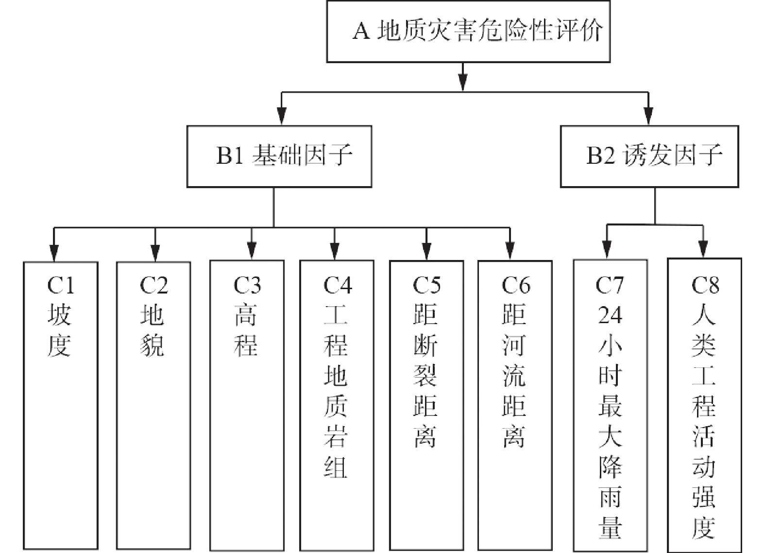
Figure 3.
Hierarchical structure diagram of geological hazard risk assessment
-
Figure 4.
Geological hazard risk assessment map in the study area
-
Figure 5.
ROC curve of hazard risk assessment results