
| Institute of Geomechanics, Chinese Academy of Geological Sciences | Host |
| Citation: |
LI Lingjing, YAO Xin, ZHOU Zhenkai, WANG Defu. 2022. The applicability assessment of Sentinel-1 data in InSAR monitoring of the deformed slopes of reservoir in the mountains of southwest China: A case study in the Xiluodu Reservoir. Journal of Geomechanics, 28(2): 281-293. doi: 10.12090/j.issn.1006-6616.2021109

|
The applicability assessment of Sentinel-1 data in InSAR monitoring of the deformed slopes of reservoir in the mountains of southwest China: A case study in the Xiluodu Reservoir
-
Abstract
Sentinel satellite is widely used in deformed slope identification and monitoring due to its high resolution, stable orbit system, large coverage capacity, short repetition time, and free data download. Since the 1963 catastrophic landslide of Vaiant in Italy, the geologic hazard on bank slopes has been one of the main problems of the reservoir in the mountainous area. Taking the Xiluodu reservoir in the upper reaches of the Jinsha River as the study area, the applicability of the Sentinel-1 SAR data in InSAR monitoring of deformed slopes of reservoir in mountainous areas was evaluated by combining PALSAR-2 and TerraSAR-X data. The results were used to evaluate whether Sentinel-1 data could replace other commercial SAR data under certain conditions. It provides a reference for future applications in related researches. The results show that: About 200 deformed slopes were interpreted by the Sentinel-1 data in the study area, including landslide, rockfall, and bank collapse. According to field investigations, the minimum projected area of deformed slope based on the Sentinel-1 data is about 2400 m2, a size of 35 m (length)×77 m (width), gathered by 16 high-value raster pixels. Overlapping mask shadow phenomenon is severe in the alpine valley area. By comparing SAR data in common satellite radar observation modes, the effective observation area is 70.3% of the ascending Sentinel-1 orbit, 68.9% of the descending Sentinel-1 orbit, 70.4% of the ascending PALSAR-2 orbit, 67.6% of the descending PALSAR-2 orbit, and 52.5% of the descending TerraSAR-X orbit in the intersection area of all SAR data used. Without considering the resolution, it can be concluded that the Sentinel-1 data in the reservoir area has an equal or more excellent observation ability than the other two SAR data. The water level rises from June to early November, and the currounding vegetation develops well, resulting in poor data coherence. Since 2017, the amount of SAR data acquired by Sentinel-1A (1B) has increased, and high-frequency observations can improve the coherence. Therefore, the SAR data can be used to effectively identify the development and change of regional deformed slopes during the water fluctuation cycle. When the SAR data is lacking for a long time, the deformation measured by some pixels between the nearest pair of SAR data could exceed the maximum InSAR measurement range, and the phase period will be lost during the unwrapping. Sentinel-1 SAR data is more suitable for trend identification of continuous small deformations due to its good continuity.
-
Keywords:
- Sentinel-1 /
- PALSAR-2 /
- TerraSAR-X /
- deformed slopes of reservoir /
- monitoring capacity
-

-
References
CHEN H K, ZHOU X H, 2016. Study on Identification Method on Failure Mode of Reservoir Landslide: Taking Qingshi Landslide in Three Gorges Reservoir as an Example[J]. Journal of Chongqing Normal University (Natural Science), 33(5): 37-41. (in Chinese with English abstract) CHEN T Z, DAI F C, 2018. Exploring the Landslide Deformation Regular Based After the Impoundment in the Xiluodu Reservoir[J]. Industial Construction, 48(Sup): 634-639. (in Chinese with English abstract) China Geological Disaster Prevention Engineering Industry Association, 2018. Guideline of InSAR Monitoring for Geo-hazard, T/CAGHP 013-2018 [S]. Beijing: China University of Geosciences Press. (in Chinese) DENG H Y, WANG C H, 2011. Engineering Geological Characteristics and Genetic Mechanism of Old Landslide of Reservoir Bank of Xiluodu Reservoir Areas[J]. Soil and Water Conservation in China, (5): 59-62. (in Chinese) DONG J, ZHANG L, LI M H, et al., 2018. Measuring precursory movements of the recent Xinmo landslide in Mao county, China with sentinel-1 and ALOS-2 PALSAR-2 datasets[J]. Landslides, 15(1): 135-144. doi: 10.1007/s10346-017-0914-8 GAO G P, YANG J H. 2003. Application of GIS in geologic disaster research [J]. Yangtze River, 34(6): 32-33. (in Chinese) GAO L, ZENG QM, 2007. Terrain deformation monitoring in Three Gorges Area using Permanent Scatterers SAR Interferometry[C]//ScanGIS′2007-Proceedings of the 11th Scandinavian Research Conference on Geographical Information Science, s, Norway, 5-7 September 2007: 261-267. INTRIERI E, RASPINI F, FUMAGALLI A, et al., 2018. The Maoxian landslide as seen from space: detecting precursors of failure with Sentinel-1 data[J]. Landslides, 15(1): 123-133. doi: 10.1007/s10346-017-0915-7 JIANG M, LI Z W, DING X L, et al., 2009. A study on the maximum and minimum detectable deformation gradients resolved by InSAR[J]. Chinese Journal of Geophysics, 52(7): 1715-1724. (in Chinese with English abstract) JIA H Y, WANG Y J, GE D Q, et al., 2020. Improved offset tracking for predisaster deformation monitoring of the 2018 Jinsha River landslide (Tibet, China) [J]. Remote Sensing of Environment, 247: 111899. doi: 10.1016/j.rse.2020.111899 HENDRON JR A J, PATTON F D., 1987. The Vaiont slide. a geotechnical analysis based on new geologic observations of the failure surface [J]. Engineering Geology, 24(1-4): 475-491. doi: 10.1016/0013-7952(87)90080-9 HERRERA G, FERNÁNDEZ-MERODO J A, et al., 2009. A landslide forecasting model using ground based SAR data: the portalet case study[J]. Engineering Geology, 105(3-4): 220-230. doi: 10.1016/j.enggeo.2009.02.009 HU J, LI Z W, DING X L, et al., 2014. Resolving three-dimensional surface displacements from InSAR measurements: a review[J]. Earth-Science Reviews, 133: 1-17. doi: 10.1016/j.earscirev.2014.02.005 KANKAKU Y, SAGISAKA M, Suzuki S. (2014). PALSAR-2 launch and early orbit status[C]//. Proceedings of 2014 IEEE geoscience and & remote sensing symposium. Quebec City, QC, Canada: IEEE: 3410-3412. LIAO M S, TANG J, WANG T, et al., 2012. Landslide monitoring with high-resolution SAR data in the Three Gorges region[J]. Sci China Earth Sci, 42(22): 217-229. (in Chinese with English abstract) LIAO M S, WANG T, 2014. Time series InSAR technology and application[M]. Beijing: Science Press. (in Chinese) LIU G X, CHEN Q, LUO X J, et al., 2019. Principle and application of InSAR[M]. Beijing: Science Press. (in Chinese) LIU X H, YAO X, ZHOU Z K, et al, 2018. Study of the technique for landslide rapid recognition by InSAR[J]. Journal of Geomechanics, 24(2): 229-237. (in Chinese with English abstract) LI B, ZHANG Q, WANG W P, et al, 2020. Geohazard monitoring and risk management of high-steep slope in the Wudongde dam area[J]. Journal of Geomechanics, 26(4): 556-564. (in Chinese with English abstract) LI L J, YAO X, Yao J M, et al., 2019a. Analysis of deformation characteristics for a reservoir landslide before and after impoundment by multiple D-InSAR observations at Jinshajiang River, China[J]. Natural Hazards, 98(2): 719-733. doi: 10.1007/s11069-019-03726-w LI M H, ZHANG L, SHI X G, et al., 2019b. Monitoring active motion of the Guobu landslide near the Laxiwa Hydropower Station in China by time-series point-like targets offset tracking[J]. Remote Sensing of Environment, 221: 80-93. doi: 10.1016/j.rse.2018.11.006 LI X E, ZHOU L, SU F Z, et al., 2021. Application of InSAR technology in landslide hazard: Progress and prospects[J]. National Remote Sensing Bulletin, 25(2): 614-629. (in Chinese with English abstract) MASSONNET D, FEIGL K L, 1998. Radar interferometry and its application to changes in the Earth's surface[J]. Reviews of Geophysics, 36(4): 441-500. doi: 10.1029/97RG03139 OUYANG L X, LI X Q, HUI F M, et al., 2017. Sentinel-1A Data Products Characteristics and the Potential Applications[J]. Chinese Journal of Polar Research, 29(2): 286-295. (in Chinese with English abstract) REN Y, 2013. Research on Layover and Shadow Detecting in InSAR[D]. Changsha National University of Defense Technology. (in Chinese with English abstract) STROZZI T, LUCKMAN A, MURRAY T, et al., 2002. Glacier motion estimation using SAR offset-tracking procedures[J]. IEEE Transactions on Geoscience and Remote Sensing, 40(11): 2384-2391. doi: 10.1109/TGRS.2002.805079 SINGLETON A, LI Z, HOEY T et al., 2014. Evaluating sub-pixel offset techniques as an alternative to D-InSAR for monitoring episodic landslide movements in vegetated terrain[J]. Remote Sensing of Environment, 147: 133-144. doi: 10.1016/j.rse.2014.03.003 SHI X G, ZHANG L, BALZ T, et al., 2015. Landslide deformation monitoring using point-like target offset tracking with multi-mode high-resolution TerraSAR-X data[J]. ISPRS Journal of Photogrammetry and Remote Sensing, 105: 128-140. doi: 10.1016/j.isprsjprs.2015.03.017 SHI X G, LIAO M S, LI M H, et al., 2016. Wide-Area Landslide Deformation Mapping with Multi-Path ALOS PALSAR Data Stacks: A Case Study of Three Gorges Area, China[J]. Remote Sensing, 8(2): 136. doi: 10.3390/rs8020136 SCOTT H, ROLAND B, BRENT D, et al., 2016. Three-dimensional surface deformation derived from airborne interferometric uavsar: application to the slumgullion landslide[J]. Journal of geophysical research. Solid earth: JGR, 121(5): 3951-3977. doi: 10.1002/2015JB012559 TANG X S, ZHENG Y R, TANG H M, et al., 2013. Numerical researches on deformation characteristics and prediction of reservoir landslides[J]. Chinese Journal of Geotechnical Engineering, 35(5): 940-947. (in Chinese with English abstract) WANG G J, XIE M W, QIU C, et al., 2011. Experiment research of D-InSAR technique on identifying landslide moving in a wide area[J]. Journal of University of Science and Technology Beijing, 33(2): 131-141. (in Chinese with English abstract) WANG Z Y, ZHANG J Z, 2013. Landslides Monitoring Based on InSAR Technique[J]. Journal of Geodesy and Geodynamics, 33(3): 87-91. (in Chinese with English abstract) XU S, WANG S X, NIU R Q, 2020. Identification of the Potential Landslide in Wushan—Fengjie in the Three Gorges Reservoir Area Based on InSAR Technology[J]. Safety and Environmental Engineering, 27(1): 32-38. (in Chinese with English abstract) XU W B, LI Z W, DING X L, et al., 2011. Interpolating atmospheric water vapor delay by incorporating terrain elevation information[J]. Journal of Geodesy, 85(9): 555-564. doi: 10.1007/s00190-011-0456-0 YOU X Z, LI S S, YANG S M, et al., 2001. InSAR Investigation in the Early Stage of the Three Gorges Project on the Yangtze River[J]. Crustal Deformation and Earthquake, 21(4): 58-66. (in Chinese with English abstract) ZHONGCUN H Z, 1990. Discussion on reservoir landslide[J]. WANG G X, trans. Bulletin of Soil and Water Conservation, 10(1): 53-64. (in Chinese) ZHANG M, ZHANG C S, YANG W M, et al, 2014. The formation conditions and stability of Chahandusi Reservoir landslide in Xunhua Country, Qinghai Province[J]. Journal of Geomechanics, 20(3): 274-284. (in Chinese with English abstract) ZHAN W J, LI Z W, WEI J C, et al., 2015. A strategy for modeling and estimating atmospheric phase of SAR interferogram[J]. Chinese Journal of Geophysics, 58(7): 2320-2329. (in Chinese with English abstract) ZHANG F, 2018. Study and Engineering Implementation on Problem Areas Detection Technology for Spaceborne InSAR[D]. Xi'an: Xidian University. (in Chinese with English abstract) ZHANG T T, YANG H L, LI DM, et al., 2019. Identification of layover and shadows regions in SAR images: taking Badong as an example[J]. Bulletin of Surveying and Mapping, (11): 85-88. (in Chinese with English abstract) ZHENG J H, HUANG B L, ZHANG Q, et al, 2020. Study on the surge induced by the collapse of dangerous rock mass in Longmen Village in Three Gorges reservoir area[J]. Journal of Geomechanics, 26(4): 533-543. (in Chinese with English abstract) 陈洪凯, 周晓涵, 2016. 库岸滑坡破坏模式识别方法研究—以三峡水库青石滑坡为例[J]. 重庆师范大学学报(自然科学版), 33(5): 37-41. 陈廷照, 戴福初, 2018. 溪洛渡库区蓄水后滑坡时空分布特征分析[J]. 工业建筑, 48(Sup): 634-639. 邓宏艳, 王成华, 2011. 溪洛渡库区库岸老滑坡工程地质特征及成因机制分析[J]. 中国水土保持, (5): 59-62. doi: 10.3969/j.issn.1000-0941.2011.05.023 高改萍, 杨建宏, 2003. GIS在地质灾害研究中的应用[J]. 人民长江, 34(6): 32-33. doi: 10.3969/j.issn.1001-4179.2003.06.011 蒋弥, 李志伟, 丁晓利, 等, 2009. InSAR可检测的最大最小变形梯度的函数模型研究[J]. 地球物理学报, 52(7): 1715-1724. doi: 10.3969/j.issn.0001-5733.2009.07.006 廖明生, 唐婧, 王腾, 等, 2012. 高分辨率SAR数据在三峡库区滑坡监测中的应用[J]. 中国科学: 地球科学, 42(2): 217-229. 廖明生, 王腾, 2014. 时间序列InSAR技术与应用[M]. 北京: 科学出版社. 刘国祥, 陈强, 罗小军, 等, 2019. InSAR原理与应用[M]. 北京: 科学出版社. 刘星洪, 姚鑫, 周振凯, 等, 2018. 滑坡灾害InSAR应急排查技术方法研究[J]. 地质力学学报, 24(2): 229-237. 李滨, 张青, 王文沛, 等, 2020. 金沙江乌东德水电站坝区高陡边坡地质灾害监测预警研究[J]. 地质力学学报, 26(4): 556-564. 李晓恩, 周亮, 苏奋振, 等, 2021. InSAR技术在滑坡灾害中的应用研究进展[J]. 遥感学报, 25(2): 614-629. 欧阳伦曦, 李新情, 惠凤鸣, 等, 2017. 哨兵卫星Sentinel-1A数据特性及应用潜力分析[J]. 极地研究, 29(2): 286-295. 任云, 2013. InSAR叠掩与阴影检测技术[D]. 长沙: 国防科学技术大学. 唐晓松, 郑颖人, 唐辉明, 等, 2013. 水库滑坡变形特征和预测预报的数值研究[J]. 岩土工程学报, 35(5): 940-947. 王桂杰, 谢谟文, 邱骋, 等, 2011. 差分干涉合成孔径雷达技术在广域滑坡动态辨识上的实验研究[J]. 北京科技大学学报, 33(2): 131-141. 王志勇, 张金芝, 2013. 基于InSAR技术的滑坡灾害监测[J]. 大地测量与地球动力学, 33(3): 87-91. 徐帅, 王尚晓, 牛瑞卿, 2020. 基于InSAR技术的三峡库区巫山—奉节段潜在滑坡识别[J]. 安全与环境工程, 27(1): 32-38. 游新兆, 李澍荪, 杨少敏, 等, 2001. 长江三峡工程库首区InSAR测量的初步研究[J]. 地壳形变与地震, 21(4): 58-66. doi: 10.3969/j.issn.1671-5942.2001.04.008 中村浩之, 1990. 论水库滑坡[J]. 王恭先, 译, 水土保持通报, 10(1): 53-64. 张淼, 张春山, 杨为民, 等, 2014. 青海循化县查汗都斯水库滑坡形成条件与稳定性分析[J]. 地质力学学报, 20(3): 274-284. doi: 10.3969/j.issn.1006-6616.2014.03.006 占文俊, 李志伟, 韦建超, 等, 2015. 一种InSAR大气相位建模与估计方法[J]. 地球物理学报, 58(7): 2320-2329. 张芳, 2018. 星载InSAR问题区域检测技术研究以及工程化实现[D]. 西安: 西安电子科技大学. 中国地质灾害防治工程行业协会, 2018. 地质灾害InSAR监测技术指南: T∕CAGHP 013-2018 [S]. 北京: 中国地质大学出版社. 张同同, 杨红磊, 李东明, 等, 2019. SAR影像中叠掩与阴影区域的识别—以湖北巴东为例[J]. 测绘通报, (11): 85-88. 郑嘉豪, 黄波林, 张全, 等, 2020. 三峡库区龙门寨危岩体崩塌产生涌浪研究[J]. 地质力学学报, 26(4): 533-543. -
Access History
Figures(11)
Tables(1)

Export File
Citation
LI Lingjing, YAO Xin, ZHOU Zhenkai, WANG Defu. 2022. The applicability assessment of Sentinel-1 data in InSAR monitoring of the deformed slopes of reservoir in the mountains of southwest China: A case study in the Xiluodu Reservoir. Journal of Geomechanics, 28(2): 281-293. doi: 10.12090/j.issn.1006-6616.2021109
Format
Content
 DownLoad:


-
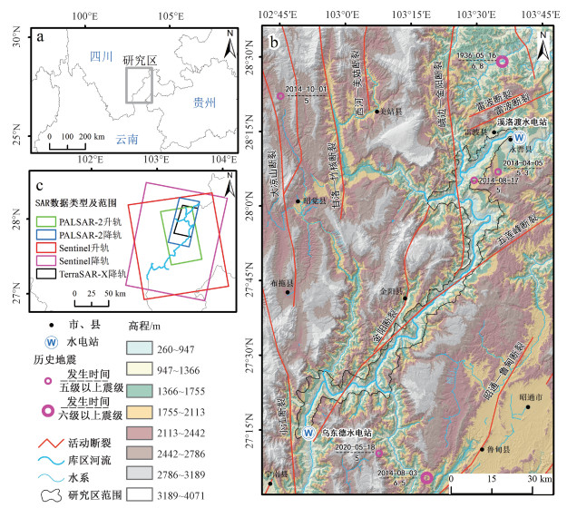
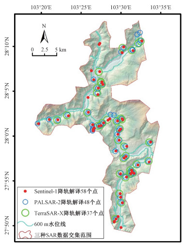
Figure 1.
The location and the geological background of the study area, and the SAR data ranges
-
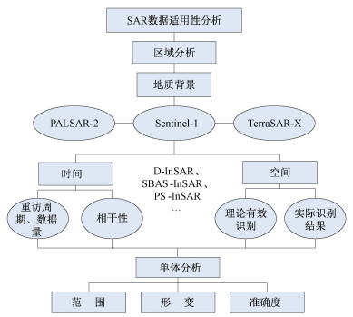
Figure 2.
Analysis flow chart
-
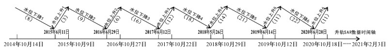
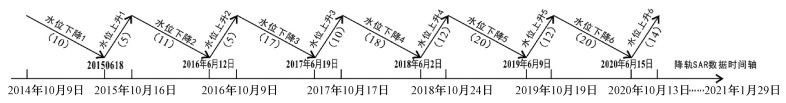
Figure 3.
Archiving of the Sentinel-1 data from the ascending orbit in periods of rising (falling) water level(The numbers in brackets are the amount of archived SAR data)
-
Figure 4.
Archive of the Sentinel-1 data from the descending orbit in periods of rising (falling) water level(The numbers in brackets are the amount of archived SAR data)
-
Figure 5.
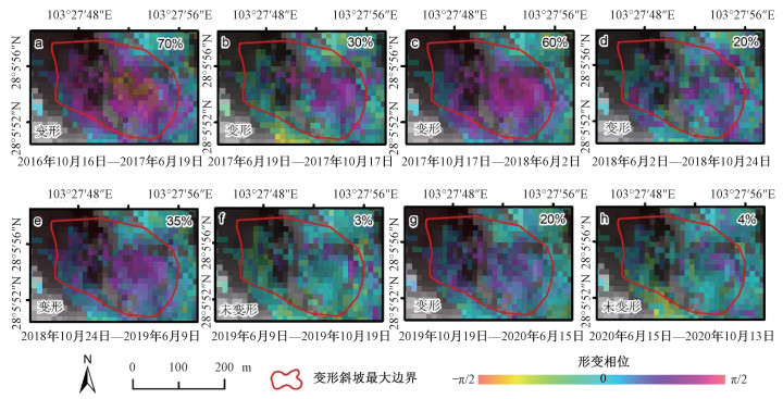
Interferometric phase of the deformed slope at different periods in the study area and the deformation status
-
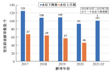
Figure 6.
The annual interpretations of deformed slopes
-
Figure 7.
Proportion of effective observations by different SAR satellites in the intersection area of SAR data
-
Figure 8.
Schematic diagram of deformed slope interpretations of three satellite SAR data on descending orbits in the same area
-
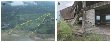
Figure 9.
Field photos of the Yizicun landslide
-
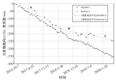
Figure 10.
Comparison of D-InSAR results based on the multi-source SAR data of the Yizicun landslide in the reservoir
-
Figure 11.
Comparison of PS-InSAR time-series deformation results based on the multi-source SAR data of the Yizicun landslide in the reservoir