
| Institute of Geomechanics, Chinese Academy of Geological Sciences | Host |
| Citation: |
CHENG Sanyou, YANG Xingke, YU Hengbin, LIU Wei. 2020. Methods of ASTER remote sensing data used in extracting mineralization and alteration information in the Hutouya mining area of the Qimantag metallogenic belt, Qinghai Province. Journal of Geomechanics, 26(3): 432-442. doi: 10.12090/j.issn.1006-6616.2020.26.03.037

|
Methods of ASTER remote sensing data used in extracting mineralization and alteration information in the Hutouya mining area of the Qimantag metallogenic belt, Qinghai Province
-
Abstract
Using ASTER remote sensing images as the data source, the extraction of mineralization and alteration anomaly in the Hutouya mining area of the Qimantag metallogenic belt in Qinghai Province is studied through two methods. One method is using the minimum noise component (MNF) transform, pixel purity index (PPI), n-Dimensional Visualization to do the end element recognition and mixture tuned matched filtering (MTMF), in order to obtain the mineral distribution map of the mining area. The other is principal component analysis, through which ferric contamination anomaly is extracted in ASTER1, 2, 3, 4 band, skarnization alteration anomaly in 1, 3, 4, 5 band, montmorillonite, illite and sericite in 3, 4, (5+6)/2 band and calcite, biomica, chlorite and other minerals in 1, 3, 4, 8 band. The results of remote sensing extraction of alteration anomaly verified by ArcGIS10.1 software are in good consistency with the mineral deposits and mineralization points determined by the field survey, indicating that the extraction results and the data processing method are reliable, which is of great guiding significance for the expansion of the prospecting scale and the discovery of mineralization enrichment areas.
-

-
References
CHEN J, ZHOU P, 2015. Extraction of linear structure and alteration information using ASTER data and prospecting prognosis for Tudun, Hami[J]. Journal of Geomechanics, 21(2):209-217. (in Chinese with English abstract) CHEN J M, SUN W D, YAN B K, et al., 2009. The application and research of the anomaly extraction process base on the ASTER multi-spectral remote sensing in Tianhu iron ore mine[J]. Xinjiang Geology, 27(4):368-372. (in Chinese with English abstract) CHEN Y, HE Z W, DENG H, et al., 2014. Identification and extraction of mineralized alteration information by ASTER remote sensing data[J]. Journal of Guilin University of Technology, 34(1):51-57. (in Chinese with English abstract) GAO H, ZHANG J L, OUYANG Y, et al., 2013. Lithological classification based on ASTER data by minimum noise fraction transform[J]. Journal of Guilin University of Technology, 33(2):259-265. (in Chinese with English abstract) GAO W L, ZHANG X J, WANG Z G, et al., 2010. Extraction of lithologic information from the east Kulun orogenic belt using ASTER remote sensing image[J]. Journal of Geomechanics, 16(1):59-69. (in Chinese with English abstract) GAO X F, XIAO P X, XIE C R, et al., 2010. Discussion on tectonic-magmatic process and mineralization in the Qimantage Region[J]. Northwestern Geology, 43(4):119-123. (in Chinese with English abstract) GENG X X, YANG J M, ZHANG Y J, et al., 2008. The application of ASTER remote sensing data for extraction of alteration anomalies information in shallow overburden area——a case study of the Baoguto porphyry copper deposit intrusion in western Junggar, Xinjiang[J]. Geological Review, 54(2):184-191. (in Chinese with English abstract) GU P Y, CHEN R M, CHA X F, et al., 2016. Exploration and practice of 1:50000 geological mapping techniques for alpine-gorge area:a case study in Beishan Area of Wushi, Xinjiang[J]. Journal of Geomechanics, 22(4):837-855. (in Chinese with English abstract) HU X H, ZHU G C, LIU H, et al., 2011. Characteristics and mineralization of the Hutouya polymetallic deposit in the Qimantage Metallogenetic Belt[J]. Geology and Prospecting, 47(2):216-221. (in Chinese with English abstract) LI K, GAO Y B, QIAN B, et al., 2015. Geochronology, geochemical characteristics and Hf isotopic compositions of granite in the Hutouya deposit, Qimantag, East Kunlune[J]. Geology in China, 42(3):630-645. (in Chinese with English abstract) LI R S, JI W H, YANG Y C, et al., 2008. Geology of Kunlun Mountains and adjacent areas[M]. Beijing:Geological Publishing House:1-400. (in Chinese) LI Z M, XUE C J, WANG X H, et al., 2007. Features of regional mineralization and analysis of the exploration development in the eastern Kunlun Mountains[J]. Geological Review, 53(5):708-718. (in Chinese with English abstract) LIU W, YANG X K, WANG S L, et al., 2014. Characteristics of ore-controlling structures of the Hutouya orefield in the Qimantage metallogenic belt, Qinghai province[J]. Geology in China, 41(1):222-234. (in Chinese with English abstract) LIU Z, ZHOU P, 2017. Information extraction of alteration of Huaniushan region, Gansu province based on ASTER data[J]. Journal of North University of China (Natural Science Edition), 38(2):124-132, 139. (in Chinese with English abstract) MA S C, FENG C Y, ZHANG D J, et al., 2013. Alteration and mineralization zoning of Hutouya polymetallic deposit in Qimantag area, Qinghai province[J]. Mineral Deposits, 32(1):109-121. (in Chinese with English abstract) MAO X C, LIU W C, DU J G, et al., 2005. Comparison between ETM+ and ASTER data for extraction of alteration information:a case study of Fenghuangshan Orefield, Tongling, Anhui province[J]. Geoscience, 19(2):309-314. (in Chinese with English abstract) POUR A B, HASHIM M, 2012. The application of ASTER remote sensing data to porphyry copper and epithermal gold deposits[J]. Ore Geology Reviews, 44:1-9. SU S, 2011. Study of mineralization law and analysis of economic value of Hutouya lead-zinc mine in the Qimatage Mine Margine of East Kulun[D]. Beijing: China University of Geosciences (Beijing): 1-127. (in Chinese with English abstract) https://kns.cnki.net/KCMS/detail/detail.aspx?dbcode=CDFD&dbname=CDFDLAST2015&filename=1011077457.nh&v=MjE2MTJxSkViUElSOGVYMUx1eFlTN0RoMVQzcVRyV00xRnJDVVI3cWZZT2RuRnlIa1ZyckpWRjI2SDdPL0dkWEo= WU Y Z, QIAO G B, CHEN D H, 2011. A preliminary study on relationship between tectonic magmatism and mineralization in Qimantage Area, eastern Kunlun Mountains[J]. Geotectonica et Metallogenia, 35(2):232-241. (in Chinese with English abstract) YAN S X, WU X B, ZHOU C X, et al., 2011. Remote sensing and spectral geology and their applications to mineral exploration[J]. Advances in Earth Science, 26(1):13-29. (in Chinese with English abstract) YANG C B, JIANG Q G, ZHU Q, et al., 2009. Altered minerals discriminating using ASTER Data at low vegetation cover area[J]. Geology and Exploration, 45(6):761-766. (in Chinese with English abstract) YANG R H, LI Z Z, CHEN X F, 2012. Information extraction of typical alteration mineral assemblage in porphyry copper using ASTER satellite data, Arequipa province of South Peru[J]. Journal of Geo-information Science, 14(3):411-418. (in Chinese with English abstract) YANG X K, HAN K, FAN Y, et al., 2016. Tectonic background and magma-thermodynamic structural features of typical orefields in Qimantage Ore Belt, Eastern Kunlun[J]. Geotectonica et Metallogenia, 40(2):201-212. (in Chinese with English abstract) YAO F J, ZHANG Y J, YANG J M, et al., 2012. Application of ASTER remote sensing data to extraction of alterration zoning information from Dexing porphyry copper deposit[J]. Mineral Deposits, 31(4):881-890. (in Chinese with English abstract) YI L W, LU A H, GU X P, et al., 2019. Evaluation of the methods for quantitative determination of Fe2+/Fe3+ ratios of magnetite from Qimantag metallogenic belts[J]. Journal of Geomechanics, 25(S1):1-4. (in Chinese with English abstract) ZHANG A K, MO X X, LI Y P, et al., 2010. New progress and significance in the Qimantage metallogenic belt prospecting, western Qinghai, China[J]. Geological Bulletin of China, 29(7):1062-1074. ZHANG D M, ZHANG A K, QU G J, et al., 2020. Metallogenic and prospecting model of Kaerqueka Iron-copper polymetallic deposit in western segment of eastern Kunlun[J]. Northwestern Geology, 53(1):91-106. (in Chinese with English abstract) ZHANG X F, LI Z M, CHEN B, et al., 2012. The contribution of the Tanjianshan group stratum to Skarnization in Qimantage region, Qinghai province[J]. Northwestern Geology, 45(1):40-47. (in Chinese with English abstract) ZHANG Y J, YANG J M, YAO F J, 2006. The extraction of OHA from different types of deposits by using ASTER data[J]. Mineral Deposits, 25(S1):507-510. (in Chinese with English abstract) ZHANG Y J, YAO F J, 2009. Application study of multi-spectral ASTER data for determination of ETM remote sensing anomaly property:Taking Wulonggou region of eastern Kunlun mountain range as example[J]. Acta Petrologica Sinica, 25(4):963-970. (in Chinese with English abstract) ZHOU D, NI Z Y, YANG Z Y, 2018. Object-oriented remote sensing information extraction method for rocky desertification in Karst area-a case study of Dafang county, Guizhou[J]. Journal of Geomechanics, 24(2):263-273. (in Chinese with English abstract) 陈建明, 孙卫东, 闫柏琨, 等, 2009. Aster多光谱遥感异常提取在新疆天湖铁矿中的应用[J].新疆地质, 27(4):368-372. 陈菁, 周萍, 2015.基于ASTER的哈密土墩地区构造及蚀变信息提取与找矿预测[J].地质力学学报, 21(2):209-217. 陈晔, 何政伟, 邓辉, 等, 2014.利用ASTER影像识别和提取矿化蚀变信息[J].桂林理工大学学报, 34(1):51-57. 高慧, 张建龙, 欧阳渊, 等, 2013.基于最小噪声分量变换的ASTER遥感数据岩性分类[J].桂林理工大学学报, 33(2):259-265. 高万里, 张绪教, 王志刚, 等, 2010.基于ASTER遥感图像的东昆仑造山带岩性信息提取研究[J].地质力学学报, 16(1):59-69. 高晓峰, 校培喜, 谢从瑞, 等, 2010.祁漫塔格地区构造-岩浆作用与成矿[J].西北地质, 43(4):119-123. 耿新霞, 杨建民, 张玉君, 等, 2008. ASTER数据在浅覆盖区蚀变遥感异常信息提取中的应用:以新疆西准噶尔包古图斑岩铜矿岩体为例[J].地质论评, 54(2):184-191. 辜平阳, 陈瑞明, 查显峰, 等, 2016.高山峡谷区1:50000地质填图技术方法探索与实践:以新疆乌什北山为例[J].地质力学学报, 22(4):837-855. 胡杏花, 朱谷昌, 刘欢, 等, 2011.祁漫塔格矿带虎头崖多金属矿矿床特征和成矿作用分析[J].地质与勘探, 47(2):216-221. 李侃, 高永宝, 钱兵, 等, 2015.东昆仑祁漫塔格虎头崖铅锌多金属矿区花岗岩年代学、地球化学及Hf同位素特征[J].中国地质, 42(3):630-645. 李荣社, 计文化, 杨永成, 等, 2008.昆仑山及邻区地质[M].北京:地质出版社:1-400. 李智明, 薛春纪, 王晓虎, 等, 2007.东昆仑区域成矿特征及有关找矿突破问题分析[J].地质评论, 53(5):708-718. 刘渭, 杨兴科, 王守良, 等, 2014.青海省祁漫塔格矿带虎头崖矿田构造控矿特征[J].中国地质, 41(1):222-234. 刘知, 周萍, 2017.基于ASTER数据的甘肃花牛山地区蚀变信息提取[J].中北大学学报(自然科学版), 38(2):124-132, 139. 马圣钞, 丰成友, 张道俊, 等, 2013.青海虎头崖矽卡岩型多金属矿床蚀变矿化分带特征研究[J].矿床地质, 32(1):109-121. 毛晓长, 刘文灿, 杜建国, 等, 2005. ETM+和ASTER数据在遥感矿化蚀变信息提取应用中的比较-以安徽铜陵凤凰山矿田为例[J].现代地质, 19(2):309-314. 苏松, 2011.东昆仑祁漫塔格成矿带虎头崖铅锌矿矿化规律和经济评价[D].北京: 中国地质大学(北京): 1-127. http://cdmd.cnki.com.cn/Article/CDMD-11415-1011077457.htm 伍跃中, 乔耿彪, 陈登辉, 2011.东昆仑祁漫塔格地区构造岩浆作用与成矿关系初步探讨[J].大地构造与成矿学, 35(2):232-241. 燕守勋, 武晓波, 周朝宪, 等, 2011.遥感和光谱地质进展及其对矿产勘查的实践应用[J].地球科学进展, 26(1):13-29. 杨长保, 姜琦刚, 朱群, 等, 2009.浅覆盖区基于ASTER数据的蚀变矿物识别方法[J].地质与勘探, 45(6):761-766. 杨日红, 李志忠, 陈秀法, 2012. ASTER数据的斑岩铜矿典型蚀变矿物组合信息提取方法:以秘鲁南部阿雷基帕省斑岩铜矿区为例[J].地球信息科学学报, 14(3):411-418. 杨兴科, 韩珂, 范阅, 等, 2016.东昆仑祁漫塔格矿带典型矿田构造背景与岩浆-热力构造特征[J].大地构造与成矿学, 40(2):201-212. 姚佛军, 张玉君, 杨建民, 等, 2012.利用ASTER提取德兴斑岩铜矿遥感蚀变分带信息[J].矿床地质, 31(4):881-890. 易立文, 鲁安怀, 谷湘平, 等, 2019.祁漫塔格成矿带磁铁矿Fe2+/Fe3+比值测定方法对比研究[J].地质力学学报, 25(S1):1-4. 张爱奎, 莫宣学, 李云平, 等, 2010.青海西部祁漫塔格成矿带找矿新进展及其意义[J].地质通报, 29(7):1062-1074. 张大明, 张爱奎, 屈光菊, 等, 2020.东昆仑西段卡而却卡铁铜多金属矿床成矿模式及找矿模型[J].西北地质, 53(1):91-106. 张晓飞, 李智明, 陈博, 等, 2012.东昆仑祁漫塔格地区滩间山群矽卡岩化成矿作用[J].西北地质, 45(1):40-47. 张玉君, 杨建民, 姚佛军, 2006.用ASTER数据进行不同类型矿床蚀变异常提取研究[J].矿床地质, 25(S1):507-510. 张玉君, 姚佛军, 2009.应用多光谱ASTER数据对ETM遥感异常的定性判别研究:以东昆仑五龙沟为例[J].岩石学报, 25(4):963-970. 周迪, 倪忠云, 杨振宇, 2018.面向对象的喀斯特地区石漠化遥感信息提取研究:以贵州省大方地区为例[J].地质力学学报, 24(2):263-273. -
Access History
Figures(12)
Tables(6)

Export File
Citation
CHENG Sanyou, YANG Xingke, YU Hengbin, LIU Wei. 2020. Methods of ASTER remote sensing data used in extracting mineralization and alteration information in the Hutouya mining area of the Qimantag metallogenic belt, Qinghai Province. Journal of Geomechanics, 26(3): 432-442. doi: 10.12090/j.issn.1006-6616.2020.26.03.037
Format
Content
 DownLoad:

-
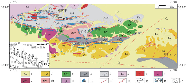
Figure 1.
Simplified geological map of the Hutouya mining area(Liu et al, 2014)
-
Figure 2.
Grayscale image of the band 1 after the MNF transformation
-
Figure 3.
Grayscale image of the band 2 after the MNF transformation
-
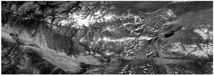
Figure 4.
Grayscale image of the band 3 after the MNF transformation
-
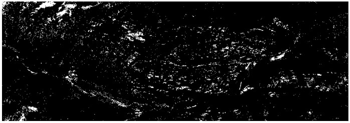
Figure 5.
PPI image generated by pixel purity index
-
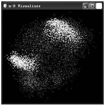
Figure 6.
End element in the n-D visualizer window
-
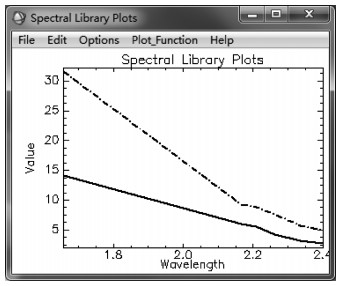
Figure 7.
Average spectral curve obtained by the n-D Mean drawing window
-
Figure 8.
Extraction map of mineralization information in the Hutouya mining area
-
Figure 9.
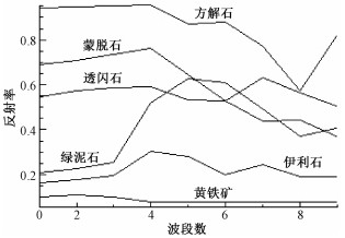
Spectra of major altered minerals in ASTER data of the study area
-
Figure 10.
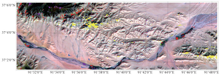
Total anomalies of the ASTER remote sensing image extraction in the Hutouya mining area
-
Figure 11.
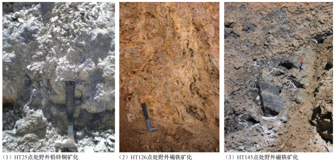
Typical outcrop photos of the field verification sites
-
Figure 12.
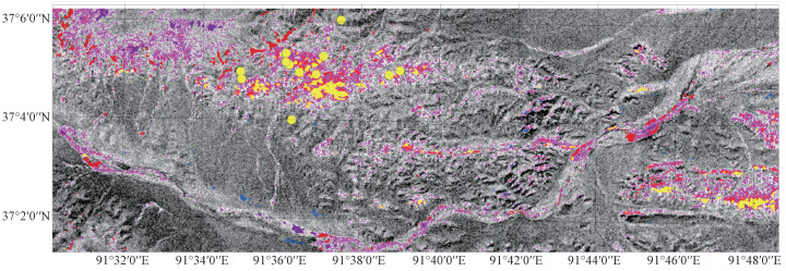
Superposition diagram of total anomalies of ASTER remote sensing image extraction and field verification points in the Hutouya mining area