
| Institute of Geomechanics, Chinese Academy of Geological Sciences | Host |
| Citation: |
Di ZHOU, Zhongyun NI, Zhenyu YANG. OBJECT-ORIENTED REMOTE SENSING INFORMATION EXTRACTION METHOD FOR ROCKY DESERTIFICATION IN KARST AREA-A CASE STUDY OF DAFANG COUNTY, GUIZHOU[J]. Journal of Geomechanics, 2018, 24(2): 263-273. doi: 10.12090/j.issn.1006-6616.2018.24.02.028

|
OBJECT-ORIENTED REMOTE SENSING INFORMATION EXTRACTION METHOD FOR ROCKY DESERTIFICATION IN KARST AREA-A CASE STUDY OF DAFANG COUNTY, GUIZHOU
-
Abstract
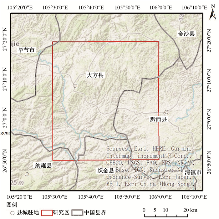
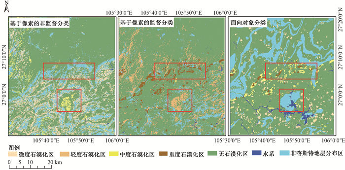
The existing pixel-based supervised and unsupervised classification methods can't meet the requirements of rocky desertification information extraction accuracy in karst rocky desertification area under the circumstances of complicated geological environment, large topographic relief and obvious shadows. In order to improve the accuracy of remote sensing image information extraction, texture feature data and topographic data are used to assist the object oriented method in the rocky desertification information extraction in karst rocky desertification area. Firstly, based on the characteristics of rocky desertification with uneven image sizes in TM/ETM+, the optimal segmentation parameters are calculated using texture and terrain factors to conduct multi-scale segmentation. Secondly, the grading indexes of rocky desertification are established based on vegetation coverage rates, rock exposure rates and slope factors. Finally, according to the grading rules of rocky desertification, spectral information and texture features, the information of rocky desertification in Karst area is extracted. The temporal TM/ETM+images of rocky desertification areas in DaFang, Guizhou, are selected for rocky desertification information extraction. The results show that comparing with pixel-based supervised classification and unsupervised classification methods, the object-oriented classification technology can effectively reduce the "salt and pepper phenomenon" caused by complicated topography, and the extraction accuracy is much better. -

-
References
周忠发.遥感和GIS技术在贵州喀斯特地区土地石漠化研究中的应用[J].水土保持通报, 2001, 21(3):52~54. ZHOU Zhongfa. Application of remote sensing and GIS technology for land desertification in Guizhou Karst Region[J]. Bulletin of Soil and Water Conservation, 2001, 21(3):52~54. (in Chinese with English abstract) 王金华. 近30年来粤北土地石漠化动态变化及发展趋势研究[D]. 广州: 华南师范大学, 2007. http://cdmd.cnki.com.cn/Article/CDMD-10574-2007184881.htm WANG Jinhua. Study on dynamic change and development trend of rocky desertification in Northern Guangdong in recent 30 years[D]. Guangzhou: South China Normal University, 2007. (in Chinese)陈起伟, 熊康宁, 兰安军.基于3S的贵州喀斯特石漠化遥感监测研究[J].干旱区资源与环境, 2014, 28(3):62~67. CHEN Qiwei, XIONG Kangning, LAN Anjun. Monitoring studies on Karst rocky desertification in Guizhou based on 3S[J]. Journal of Arid Land Resources and Environment, 2014, 28(3):62~67. (in Chinese with English abstract) Gill T K, Phinn S R, Armston J D, et al. Estimating tree-cover change in Australia:Challenges of using the MODIS vegetation index product[J]. International Journal of Remote Sensing, 2009, 30(6):1547~1565. doi: 10.1080/01431160802509066 岳跃民, 张兵, 王克林, 等.石漠化遥感评价因子提取研究[J].遥感学报, 2011, 15(4):722~736. YUE Yuemin, ZHANG Bing, WANG Kelin, et al. Remote sensing of indicators for evaluating karst rocky desertification[J]. Journal of Remote Sensing, 2011, 15(4):722~736. (in Chinese with English abstract) Townsend P A, Walsh S J. Remote sensing of forested wetlands:Application of multitemporal and multispectral satellite imagery to determine plant community composition and structure in southeastern USA[J]. Plant Ecology, 2001, 157(2):129~149. 李朝阳, 况顺达, 李志忠, 等.喀斯特石漠化遥感信息增强与监测技术[J].桂林工学院学报, 2007, 27(1):30~35. LI Zhaoyang, KUANG Shunda, LI Zhizhong, et al. RS monitoring technology in karst rocky desertification[J]. Journal of Guilin University of Technology, 2007, 27(1):30~35. (in Chinese with English abstract) 杨奇勇, 蒋忠诚, 马祖陆, 等.基于地统计学和遥感的岩溶区石漠化空间变异特征[J].农业工程学报, 2012, 28(4):243~247. YANG Qiyong, JIANG Zhongcheng, MA Zulu, et al. Spatial variability of karst rock desertification based on geostatistics and remote sensing[J]. Transactions of the CSAE, 2012, 28(4):243~247. (in Chinese with English abstract) Gambarova E, Gambarov A, Ismayilov J. Applying neural networks in rare vegetation communities classification of remotely sensed images[J]. Optical Memory and Neural Networks, 2008, 17(2):157~166. doi: 10.3103/S1060992X08020100 胡宝清, 王世杰.基于3S技术的区域喀斯特石漠化过程、机制及风险评估:以广西都安为例[M].北京:科学出版社, 2008. HU Baoqing, WANG Shijie. Process, Mechanism and risk assessment of regional Karst desertification based on 3S technology:a case study of Du'an, Guangxi[M]. Beijing:Science Press, 2008. (in Chinese) Willhauck G, Schneider T, De Kok R, et al. Comparison of object oriented classification techniques and standard image analysis for the use of change detection between SPOT multispectral satellite images and aerial photos[A]. Proceedings of XIX ISPRS Congress[C]. Amsterdam: IAPRS, 2000. 贾明明, 任春颖, 刘殿伟, 等.基于环境星与MODIS时序数据的面向对象森林植被分类[J].生态学报, 2014, 34(24):7167~7174. JIA Mingming, REN Chunying, LIU Dianwei, et al. Object-oriented forest classification based on combination of HJ-1 CCD and MODIS-NDVI data[J]. Acta Ecologica Sinica, 2014, 34(24):7167~7174. (in Chinese with English abstract) 谢雨萍, 吴虹, 刘泽东, 等.恭城县岩溶石漠化环境变化定量遥感研究[J].桂林工学院学报, 2009, 29(1):65~71. XIE Yuping, WU Hong, LIU Zedong, et al. Environment change of karst rocky desertification by quantitative remote sensing in Gongcheng[J]. Journal of Guilin University of Technology, 2009, 29(1):65~71. (in Chinese with English abstract) Lupo F, Linderman M, Vanacker V, et al. Categorization of land-cover change processes based on phenological indicators extracted from time series of vegetation index data[J]. International Journal of Remote Sensing, 2007, 28(11):2469~2483. doi: 10.1080/01431160600921943 孟小军, 莫源富.基于遥感技术的打狗河流域1999-2009年间石漠化及绿化研究[J].桂林理工大学学报, 2013, 33(4):622~628. MENG Xiaojun, MO Yuanfu. Rocky desertification and afforestation of Dagou River basin during 1999-2009 based on remote sensing technology[J]. Journal of Guilin University of Technology, 2013, 33(4):622~628. (in Chinese with English abstract) 童立强.西南岩溶石山地区石漠化信息自动提取技术研究[J].国土资源遥感, 2003, (4):35~38. doi: 10.6046/gtzyyg.2003.04.09 TONG Liqiang. A method for extracting remote sensing information from rocky desertification areas in Southwest China[J]. Remote Sensing for Land & Resources, 2003, (4):35~38. (in Chinese with English abstract) doi: 10.6046/gtzyyg.2003.04.09 林雪. 面向林地信息的高分一号遥感影像融合与分类研究[D]. 北京: 北京林业大学, 2016. http://cdmd.cnki.com.cn/Article/CDMD-10022-1016145061.htm LIN Xue. Study on fusion algorithms and classincation methods for GF-1 data oriented to forestland information[D]. Beijing: Beijing Forestry University, 2016. (in Chinese with English abstract)YANG Panpan. Research on object-oriented vegetation classification method based on texture features of high resolution remote sensing images[J]. Kunming:Yunnan Normal University, 2017. (in Chinese with English abstract) 梁茂昆. 基于面向对象及Landsat影像的广州市城市空间格局演变研究[D]. 抚州: 东华理工大学, 2017. LIANG Maokun. Research on the evolution of Guangzhou urban spatial pattern based on object-oriented and Landsat images[D]. Fuzhou: East China University of Technology, 2017. (in Chinese with English abstract) 李海霞. 高分辨率遥感影像对象分类方法研究及其城乡规划监测应用[D]. 北京: 中国农业大学, 2014. http://cdmd.cnki.com.cn/Article/CDMD-10019-1014223423.htm LI Haixia. Study on the methods of object classification and its application on urban and rural plan monitoring with high spatial resolution remotely sensed data[D]. Beijing: China Agricultural University, 2014. (in Chinese with English abstract)陈建容. 面向对象的土地利用/覆被信息提取——以乐山市GF-1号影像为例[D]. 成都: 成都理工大学, 2016. http://www.wanfangdata.com.cn/details/detail.do?_type=degree&id=Y3048461 CHEN Jianrong. Object-oriented land use/cover information extraction[D]. Chengdu: Chengdu University of Technology, 2016. (in Chinese)贾伟. 面向对象的复杂地形区土地利用信息提取研究[D]. 西宁: 青海师范大学, 2015. http://cdmd.cnki.com.cn/Article/CDMD-10746-1015661361.htm JIA Wei. Land use information extraction for complicated terrain regions from object-oriented classification technique[D]. Xining: Qinghai Normal University, 2015. (in Chinese with English abstract)欧阳华璘, 沈敬伟, 周廷刚.面向对象分类方法在台风灾害信息提取中的应用研究[J].自然灾害学报, 2016, 25(6):9~17. OUYANG Hualin, SHEN Jingwei, ZHOU Tinggang. Application of object-oriented classification method to typhoon disaster information extraction[J]. Journal of Natural Disaster, 2016, 25(6):9~17. (in Chinese with English abstract) 李雪冬, 杨广斌, 李蔓, 等.面向对象的喀斯特地区土地利用遥感分类信息提取-以贵州毕节地区为例[J].中国岩溶, 2013, 32(2):231~237. LI Xuedong, YANG Guangbin, LI Man, et al. RS classification information extraction of landuse in karst area by means of object oriented approach:a case in Bijie, Guizhou[J]. Carsologica Sinica, 2013, 32(2):231~237. (in Chinese with English abstract) 刘海龙. 面向对象的石漠化遥感监测及过程模拟研究[D]. 昆明: 昆明理工大学, 2015. http://cdmd.cnki.com.cn/Article/CDMD-10674-1015636041.htm LIU Hailong. Object-oriented remote sensing monitoring and process simulation of rocky desertification[D]. Kunming: Kunming University of Science and Technology, 2015. (in Chinese)曹密媛. 基于遥感影像的地物要素智能识别与提取研究[D]. 西安: 长安大学, 2015. http://www.wanfangdata.com.cn/details/detail.do?_type=degree&id=D748355 CAO Miyuan. Based on the feature elements of intelligent recognition and extraction of remote sensing image[D]. Xi'an: Chang'an University, 2015. (in Chinese with English abstract)佘宇晨. 基于GF-2光谱特征的石漠化信息自动提取[D]. 株洲: 中南林业科技大学, 2017. http://cdmd.cnki.com.cn/Article/CDMD-10538-1017117982.htm SHE Yuchen. Automatic extraction of desertification information based on GF-2 spectral characteristics[D]. Zhuzhou: Central South University of Forestry & Technology, 2017. (in Chinese with English abstract)苏伟, 李京, 陈云浩, 等.基于多尺度影像分割的面向对象城市土地覆被分类研究-以马来西亚吉隆坡市城市中心区为例[J].遥感学报, 2007, 11(4):521~530. doi: 10.11834/jrs.20070472 SU Wei, LI Jing, CHEN Yunhao, et al. Object-oriented urban land-cover classification of multi-scale image segmentation method——a case study in Kuala Lumpur City center, Malaysia[J]. Journal of Remote Sensing, 2007, 11(4):521~530. (in Chinese with English abstract) doi: 10.11834/jrs.20070472 LIAO Ning, XU Lisha, QIAN Xiaoshan. Texture classification based on multi-scale wavelet[J]. Journal of System Simulation, 2015, 27(9):1951~1959. 熊康宁.喀斯特石漠化的遥感-GIS典型研究[M].地质出版社, 2002 Xiong Kangning. A Typical Remote Sensing-GIS Study of Karst Rocky Desertification[M]. Geological Publishing House, 2002(in Chinese) -
Access History
Figures(10)
Tables(5)

Export File
Citation
Di ZHOU, Zhongyun NI, Zhenyu YANG. OBJECT-ORIENTED REMOTE SENSING INFORMATION EXTRACTION METHOD FOR ROCKY DESERTIFICATION IN KARST AREA-A CASE STUDY OF DAFANG COUNTY, GUIZHOU[J]. Journal of Geomechanics, 2018, 24(2): 263-273. doi: 10.12090/j.issn.1006-6616.2018.24.02.028
Format
Content
 DownLoad:


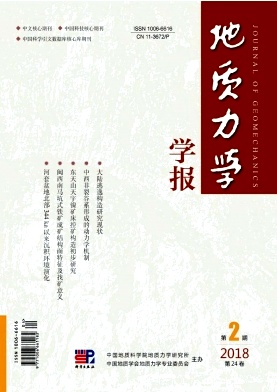
- Figure 1. Location map of the study area
- Figure 2. Flow chart of rocky desertification remote sensing image information extraction
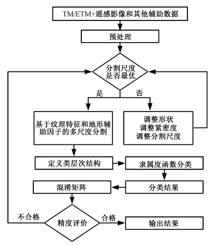
- Figure 3. Texture feature data
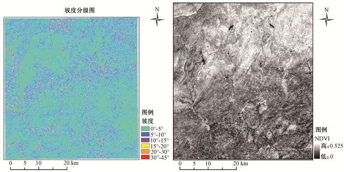
- Figure 4. Results of gradient and NDVI information extraction
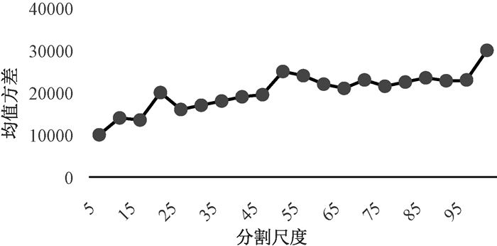
- Figure 5. Mean variance curve
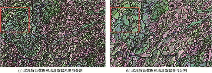
- Figure 6. Comparison charts of segmentation results
- Figure 7. Comparison of information extraction results of rocky desertification in study area
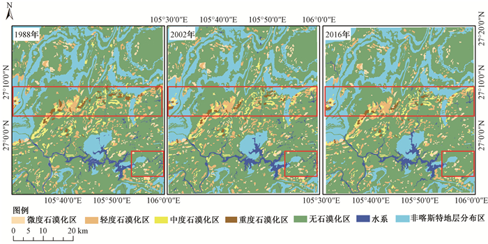
- Figure 8. Distribution of rocky desertification in study area
- Figure 9. Maps of field verification
- Figure 10. Pictures of field verification in desertification areas