
| Institute of Geomechanics, Chinese Academy of Geological Sciences | Host |
| Citation: |
Xinghong LIU, Xin YAO, Zhenkai ZHOU, Lingjing LI, Jiaming YAO. STUDY OF THE TECHNIQUE FOR LANDSLIDE RAPID RECOGNITION BY INSAR[J]. Journal of Geomechanics, 2018, 24(2): 229-237. doi: 10.12090/j.issn.1006-6616.2018.24.02.024

|
STUDY OF THE TECHNIQUE FOR LANDSLIDE RAPID RECOGNITION BY INSAR
-
Abstract
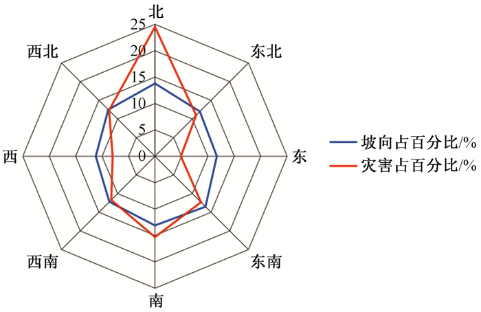
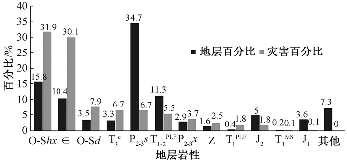
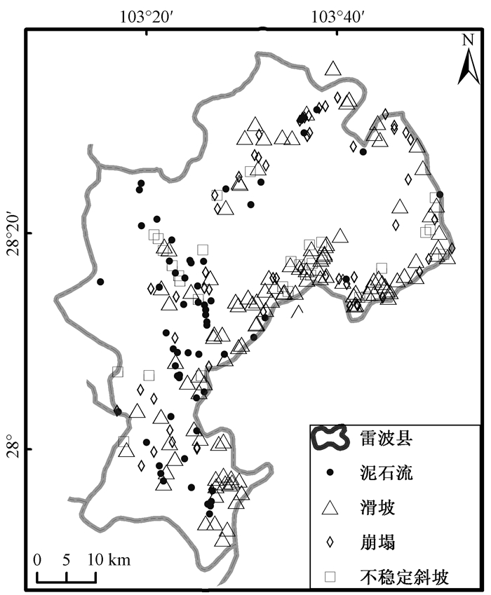
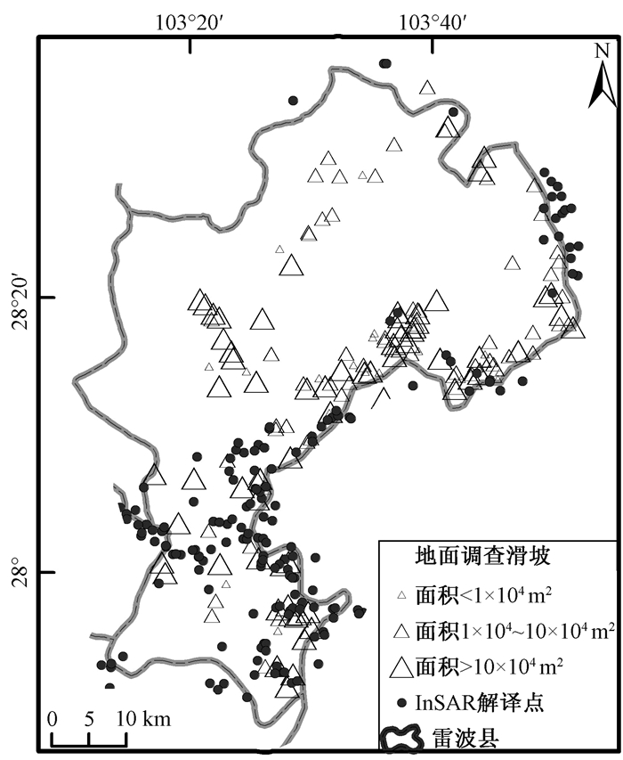
An active landslide rapid recognition method, based on InSAR deformation and assisted by optical remote sensing, geomorphologic features and geological conditions, is presented in this article and Leibo County of Sichuan Province is chosen to be the study area. Four type of SAR data, PALSAR-1/2 as-/descend and Senitnel-1A/B de-/ascend are processed, with interpretation of 163 landslides overall and analysis of spatial and temporal distribution, from which some important conclusions are drawn. (1) InSAR can trace long and small deformation so as to realize effective recognition of active landslides; (2) The use of multiple types SAR data can overcome the shortages of InSAR, such as layover, shadow, incoherence, to improve the efficiency, effect and timeliness; (3) Compared with field investigation results, landslides recognized by InSAR are more comprehensive and accurate, especially for high-position and centralized landslides, and therefore InSAR can be taken as one of the important methods for landslide survey; (4) The landslides in Leibo county mainly occurred along the Jinsha river and the Meigu river, on the north slope and slope areas with a gradient from 30° to 40°. The overall distribution of geological hazards in each stratum is even, except for the Cambrian and Ordovician-Silurian with a relatively high ratio.-
Keywords:
- landslide /
- geological hazard recognition /
- InSAR /
- SAR data /
- Leibo County in Sichuan province
-

-
References
许强, 汤明高, 徐开祥, 等.滑坡时空演化规律及预警预报研究[J].岩石力学与工程学, 2008, 27(6):1104~1112. XU Qiang, TANG Minggao, XU Kaixiang, et al. Research on space-time evolution laws and early warning-prediction of landslides[J]. Chinese Journal of Rock Mechanics and Engineering, 2008, 27(6):1104~1112. (in Chinese with English abstract) Ferretti A. Satellite InSAR data:reservoir monitoring from space[M]. Houten:European Association of Geoscientists & Engineers, 2014. 廖明生, 王腾.时间序列InSAR技术与应用[M].北京:科学出版社, 2014. LIAO Mingsheng, WANG Teng. Time series InSAR technology and application[M]. Beijing:Science Press, 2014. (in Chinese) Fruneau B, Achache J, Delacourt C. Observation and modelling of the Saint-Étienne-de-Tinée landslide using SAR interferometry[J]. Tectonophysics, 1996, 265(3/4):181~190. Rott H, Scheuchl B, Siegel A, et al. Monitoring very slow slope movements by means of SAR interferometry:a case study from a mass waste above a reservoir in the Ötztal Alps, Austria[J]. Geophysical Research Letters, 1999, 26(11):1629~1632. doi: 10.1029/1999GL900262 Yin, Y., Zheng, W., Liu, Y., et al. Integration of GPS with InSAR to monitoring of the Jiaju landslide in Sichuan, China[J]. Landslides, 2010, 7:359~365. doi: 10.1007/s10346-010-0225-9 Yao X, Li L J, Zhang Y S, et al. Types and characteristics of slow-moving slope geo-hazards recognized by TS-InSAR along Xianshuihe active fault in the eastern Tibet Plateau[J]. Natural Hazards, 2017, 88(3):1727~1740. doi: 10.1007/s11069-017-2943-y 陈进, 徐平.金沙江科学考察的几个问题及思考[J].长江科学院院报, 2013, 30(7):1~6. CHEN Jin, XU Ping. Considerations on the scientific investigation of Jinsha River[J]. Journal of Yangtze River Scientific Research Institute, 2013, 30(7):1~6. (in Chinese with English abstract) 曾陈萍, 张宏平.物联网技术在山洪灾害监测预警系统中的应用研究[J].西昌学院学报·自然科学版, 2014, 28(3):56~59. ZENG Chenping, ZHANG Hongping. A review of the application of internet of things in the mountain torrent disaster monitoring and early-warning system[J]. Journal of Xichang College·Natural Science Edition, 2014, 28(3):56~59. (in Chinese with English abstract) 孙瑜, 李宏俊, 曹树波, 等.四川雷波碉楼沟泥石流特征及防治对策[J].地质灾害与环境保护, 2017, 28(1):1~6. SUN Yu, LI Hongjun, CAO Shubo, et al. Features and preventive countermeasures of potential debris flow in Diaolou Gully, Leibo county, Sichuan province[J]. Journal of Geological Hazards and Environment Preservation, 2017, 28(1):1~6. (in Chinese with English abstract) 陈炳蔚, 李永森, 符振康.金沙江构造带及邻区的构造变形特征[J].青藏高原地质文集, 1991, 21:222~234. CHEN Bingwei, LI Yongsen, FU Zhenkang. Deformations of Jinshajiang tectonic belt and its adjacent areas[J]. Contribution to the Geology of the Qinghai-Xizang (Tibet) Platean, 1991, 21:222~234. (in Chinese with English abstract) 姚鑫, 许冲, 戴福初, 等.四川汶川Ms8级地震引发的滑坡与地层岩性、坡度的相关性[J].地质通报, 2009, 28(8):1156~1162. YAO Xin, XU Chong, DAI Fuchu, et al. Contribution of strata lithology and slope gradient to landslides triggered by Wenchuan Ms 8 earthquake, Sichuan, China[J]. Geological Bulletin of China, 2009, 28(8):1156~1162. (in Chinese with English abstract) Colesanti C, Wasowski J. Investigating landslides with space-borne Synthetic Aperture Radar (SAR) interferometry[J]. Engineering Geology, 2006, 88(3/4):173~199. Waltham T. Foundations of engineering geology[M]. 2nd ed. Boca Raton:CRC Press, 2002. -
Access History
Figures(10)
Tables(1)

Export File
Citation
Xinghong LIU, Xin YAO, Zhenkai ZHOU, Lingjing LI, Jiaming YAO. STUDY OF THE TECHNIQUE FOR LANDSLIDE RAPID RECOGNITION BY INSAR[J]. Journal of Geomechanics, 2018, 24(2): 229-237. doi: 10.12090/j.issn.1006-6616.2018.24.02.024
Format
Content
 DownLoad:

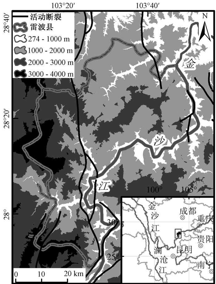
- Figure 1. Location of Leibo County
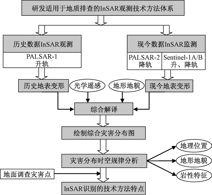
- Figure 2. Work flow chart of landslide detection by InSAR
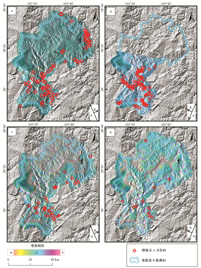
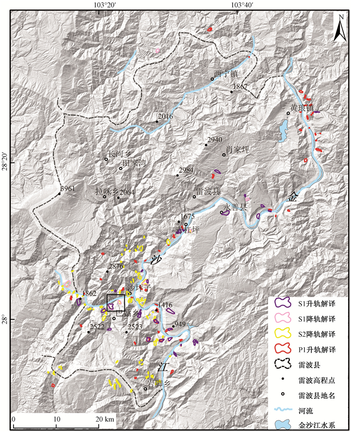
- Figure 3. Coverage area of SAR data and interpretation map of landslides
- Figure 4. Comprehensive map of hazards
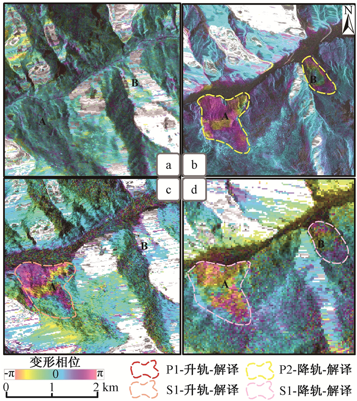
- Figure 5. Interpretation map of iframing images
- Figure 6. Statistical graph of hazard sites according to gradient
- Figure 7. Statistical graph of hazard sites according to aspect
- Figure 8. Percentage of landslides in different strata and lithologies
- Figure 9. Geological hazard sites in Leibo County through field survey
- Figure 10. Comparison between landslides detected by InSAR and those surveyed in field