
| China Geological Survey Chinese Academy of Geological Sciences | Host |
| 科学出版社 | Publish |
| Citation: |
SUN Yu, LIU Jiajun, ZHAO Yingjun, ZHAI Degao, LIU Zhenjiang, ZHANG Yafeng, ZHANG Fangfang, TIAN Feng, QIN Kai. 2022. Alteration mineral mapping based on the GF-5 hyperspectral data and its geological application——An example of the Huaniushan area in Guazhou County of Gansu Province[J]. Geology in China, 49(2): 558-574. doi: 10.12029/gc20220214

|
Alteration mineral mapping based on the GF-5 hyperspectral data and its geological application——An example of the Huaniushan area in Guazhou County of Gansu Province
-
Abstract
This paper is the result of mineral exploration engineering.
Objective The GF-5 AHSI satellite hyperspectral data, featured by the integration of both image and spectrum, can be utilized to directly identify alteration minerals according to their fine spectral characteristics. Large-area wide-range hyperspectral data can be easily obtained by one transit imaging, which can well support the survey of land natural resources. This work extracted alteration minerals using the GF-5 hyperspectral data, and conducted further analysis and field verification, in an attempt to promote the deepening application of China's satellite hyperspectral data in geological field.
Methods Technical workflows of preprocessing GF-5 hyperspectral data and alteration mineral mapping were established. Based on the improvement of the traditional spectral angle matching algorithm, a new spectral matching method of the whole spectral shape synergy with absorption peak position was proposed, and the corresponding algorithm module with the Python language was developed. Taking the Huaniushan area of Gansu Province as an example, we conducted mineral mapping, and comprehensively analyzed multi-source geological elements including lithology, structure, and alteration. The extracted alteration minerals were then verified by field survey and ASD spectral measurements.
Results Nine types of alteration minerals were successfully extracted using the GF-5 hyperspectral data, i.e., limonite, hematite, chlorite, calcite, dolomite, short-wave sericite, medium- to short-wave sericite, medium- to long-wave sericite and long-wave sericite, to describe the distribution of alteration minerals with an area of 3600 km2. The directionally distributed dolomite and calcite minerals reflect the surface exposure of sedimentary or metamorphic strata with carbonate composition. Chlorite minerals reveal the distribution of geological bodies rich in amphibole. Limonite and hematite minerals are indicative of the hydrothermal activities related to acid granites. Short-wave sericite was mainly distributed in the monzogranite. Medium- to short-wave sericite is suggestive of the hydrothermal activity of special structural section such as the contact zone between intermediate and acid rock masses and the old Dunhuang Complex. Medium- to long-wave sericite was closely related to the NE-trending fault. Long-wave sericite indicates the presence of hydrothermal activity before the Early Carboniferous.
Conclusions The GF-5 hyperspectral data can extract nine types of alteration minerals including limonite, and the field verification confirms the reliability of alteration mineral mapping. Different alteration minerals may be interpreted from varying aspects. Carbonate minerals are inferred to be closely related to sedimentary or metamorphic strata, while sericite minerals mostly reflect hydrothermal activities related to intermediate to acid rock mass and fault structure. It is considered that the GF-5 hyperspectral data can rapidly identify geological bodies, and can help to revise geological boundary and locate fresh samples, which will effectively serve the basic geological survey and mineral geological exploration in the field of natural resources.
-

-
References
Chen Liang, Liu Xi, Zhang Yuan. 2007. A study of image classification based on MLC combined with spectral angle[J]. Engineering of Surveying and Mapping, 16(3): 40-42 (in Chinese with English abstract). Clark R N, Roush T L. 1984. Reflectance spectroscopy: quantitative analysis techniques for remote sensing applications[J]. Journal of Geophysical Research, 89(B7): 6329-6340. doi: 10.1029/JB089iB07p06329 Cui Jing, Yan Bokun, Dong Xinfeng, Zhang Shimin, Wang Runsheng. 2015. Temperature and emissivity separation and mineral mapping based on airborne TASI hyperspectral thermal infrared data[J]. International Journal of Applied Earth Observation and Geoinformation, 40: 19-28. doi: 10.1016/j.jag.2015.03.014 de Linaje V A, Khan S D, Bhattacharya J. 2018. Study of carbonate concretions using imaging spectroscopy in the Frontier Formation, Wyoming[J]. International Journal of Applied Earth Observation and Geoinformation, 66: 82-92. doi: 10.1016/j.jag.2017.11.010 Dong Xinfeng, Gan Fuping, Li Na, Yan Bokun, Zhang Lei, Zhao Jiaqi, Yu Junchuan, Liu Rongyuan, Ma Yanni. 2020. Fine mineral identification of GF-5 hyperspectral image [J]. Journal of Remote Sensing, 24(4): 454-464(in Chinese with English abstract). Gan Fuping, Wang Runsheng, Ma Ainai. 2003. Spectral identification tree(SIT) for mineral extraction based on spectral characteristics of minerals[J]. Earth Science Frontiers, 10(2): 445-454(in Chinese with English abstract). Hu Bin, Xu Yongyang, Wan Bo, Wu Xincai, Yi Guihua. 2018. Hydrothermally altered mineral mapping using synthetic application of Sentinel-2A MSI, ASTER and Hyperion data in the Duolong area, Xizang Plateau, China[J]. Ore Geology Reviews, 101: 384-397. doi: 10.1016/j.oregeorev.2018.07.017 Jain R, Sharma R U. 2019. Airborne hyperspectral data for mineral mapping in southeastern Rajasthan, India[J]. International Journal of Applied Earth Observation and Geoinformation, 81: 137-145. doi: 10.1016/j.jag.2019.05.007 Kruse F A, Lefkoff A B, Boardman J W, Heidebrecht K B, Shapiro A T, Barloon P J, Goetz A F H. 1993. The spectral image processing system(SIPS)-interactive visualization and analysis of imaging spectrometer data[J]. Remote Sensing of Environment, 42(2/3): 145-163. Kumar C, Chatterjee S, Oommen T, Guha A. 2020. Automated lithological mapping by integrating spectral enhancement techniques and machine learning algorithms using AVIRIS-NG hyperspectral data in Gold-bearing granite-greenstone rocks in Hutti, India[J]. International Journal of Applied Earth Observation and Geoinformation, 86: 102006. doi: 10.1016/j.jag.2019.102006 Kurz T H, Buckley S J, Howell J A, Schneider D. 2008. Geological outcrop modeling and interpretation using ground based hysperspectral and laser scanning data fusion[EB/OL]. http://www.linkfast.com.tw/file/Example/RIEGL_TLS/RIEGL_2/isprs200.pdf. Li Guanghui, Wang Cheng, Zheng Zhaojun, Xi Xiaohun, Yue Cairong. 2013. Study on glacier classification methods of airborne hyperspectral data——A case study of the Zhongxi-1 glacier[J]. Remote Sensing Technology and Application, 28(5): 766-772(in Chinese with English abstract). Liu Dechang, Qiu Junting, Tong Qinlong, Xie Tao, Yang Yanjie, Wang Zitao. 2018. Airborne hyperspectral study of spatial relationship between oil and gas leakage and salinization in Jimusar area[J]. Geology in China, 45(5): 1062-1073(in Chinese with English abstract). Liu Dechang, Tong Qinlong, Li Zhizhong, Zhao Yingjun, Yang Yanjie, Wang Maozhi, Xie Tao, Ye Fawang, Qiu Junting, Wang Zitao. 2019. Research on oil-gas exploration using airborne hyperspectral remote sensing and its application effect[J]. Acta Geologica Sinica, 93(1): 272-284(in Chinese with English abstract). Liu Huize, Wu Ke, Xu Honggen, Xu Ying. 2021. Lithology classification using TASI thermal infrared hyperspectral data with convolutional neural networks[J]. Remote Sensing, 13(16): 3117. doi: 10.3390/rs13163117 Liu Yinnian, Sun Dexin, Hu Xiaoning, Liu Shufeng, Cao Kaiqin, Chai Mengyang, Liao Qingjun, Zuo Zhiqiang, Hao Zhenyi, Duan Weibo, Zhou Weiyinuo, Zhang Jing, Zhang Ying. 2020. Development of visible and short-wave infrared hyperspectral imager onboard GF-5 satellite[J]. Journal of Remote Sensing, 24(4): 333-344(in Chinese with English abstract). Lü Xinbiao, Zhu Jiang, Cao Xiaofeng, ChenChao, WuChunming, Hu Qincheng. 2012. Magmatismand its metallogenetic effects duringthe Paleozoic-Triassiccontinental crustal construction in the Liuyuan area, south Beishan, NW China [J]. Geological Scienceand Technology Information, 31(5): 119-127, 135(in Chinese with English abstract). Okyay U, Khan S D. 2016. Remote detection of fluid-related diagenetic mineralogical variations in the Wingate Sandstone at different spatial and spectral resolutions[J]. International Journal of Applied Earth Observation and Geoinformation, 44: 70-87. doi: 10.1016/j.jag.2015.08.001 Qin Bangyong, Liu Zhiwen1, Li Shengyang. 2018. Application of Tiangong-1 hyperspectral data in land[J]. Manned Spaceflight, 24(4): 546-552(in Chinese with English abstract). Salles R D, de Souza C R, Cudahy T, Vicente L E, Monteiro L V S. 2017. Hyperspectral remote sensing applied to uranium exploration: A case study at the Mary Kathleen metamorphic-hydrothermal U-REE deposit, NW, Queensland, Australia[J]. Journal of Geochemical Exploration, 179: 36-50. doi: 10.1016/j.gexplo.2016.07.002 Si Xuefeng, Zhou Jiqiang, Zhang Yucheng, Qiao Hua, Zhang Hua, Lin Sen. 2000. Gold deposit types and typical gold deposits in Liuyuan gold mineralization concentration area, Beishan, Gansu Province[J]. Northwest Geology, 33(1): 13-26(in Chinese with English abstract). Sun Lei, Khan S D, Sarmiento S, Lakshmikantha M R, Zhou Huawei. 2017. Ground-based hyperspectral imaging and terrestrial laser scanning for fracture characterization in the Mississippian Boone Formation[J]. International Journal of Applied Earth Observation and Geoinformation, 63: 222-233. doi: 10.1016/j.jag.2017.08.008 Sun Yongbin, Wang Ruijun, Wei Benzan, Wang Bing, Dong Shuangfa, Li Cunjin, Li Mingsong. 2018. The application of hyperspectral remote sensing ground-air integrated prediction method to the copper gold deposit prospecting in Kalatag area, Xinjiang[J]. Geology in China, 45(1): 178-191(in Chinese with English abstract). Sun Yu, Nie Jiangtao, Tian Feng, Qin Kai, Yang Guofang, Wang Jian. 2015b. Alteration mineral mapping of the Xiangshan uranium core using HySpex imaging hyperspectral data and its geological significance[J]. Geology and Exploration, 51(1): 165-174(in Chinese with English abstract). Sun Yu, Zhao Yingjun, Li Hanbo, Lu Donghua, Tian Feng, Qin Kai, Yang Guofang, Zhou Jiajing, Liu Pengfei. 2015a. HySpex hyperspectral mineral mapping of Asiha gold ore district in Dulan County Qinghai Province and its prospecting implications[J]. Acta Geologica Sinica, 89(1): 195-203(in Chinese with English abstract). van der Meer F. 2000. Spectral curve shape matching with a continuum removed CCSM algorithm[J]. International Journal of Remote Sensing, 21(16): 3179-3185. doi: 10.1080/01431160050145063 Wang Denghong, Zhao Zhi, Yu Yang, Dai Jingjing, Deng Maochun, Zhao Ting, Liu Lijun. 2018. Exploration and research progress on ion-adsorption type REE deposit in South China[J]. China Geology, 1: 415-424. Wang Runsheng, Chen Wei, Yang Suming, Zhang Ruijiang, Ge Daqing, Zhang Xiaokun, Zhang Zhenhua, Wang Pinqing, Guo Xiaofang, Li Li, Xiong Shengqing, Nie Hongfeng, Liang Shuneng, Qi Zerong, Yang Jinzhong, Yan Baikun, Zhao Fuyue, Fan Jinghui, Tong Liqiang, Lin Jian, Gan Fuping. 2011. Geological remote sensing technology and its application[J]. Acta Geologica Sinica, 85(11): 1699-1743(in Chinese with English abstract). Wu Junjun, Gao Zhihai, LiI Zengyuan, Wang Hongyan, Pang Yong, Sun Bin, Li Changlong, Li Xuzhi, Zhang Jiuxing. 2014. Estimation for sparse vegetation informationin desertification region basedon Tiangong-1 hyperspectral image[J]. Spectroscopy and Spectral Analysis, 34(3): 751-756. Xiu Liancun, Zheng Zhizhong, Yang Bin, Yin Liang, Gao Yang, Jinag Yuehua, Huang Yan, Zhou Quanping, Shi Jianlong, Dong Jinxin, Chen Chunxia, Liang Sen, Yu Zhengkui. 2021. Application of airborne hyperspectral imaging technology to the ecological environment protection of Jiangsu, Anhui and Zhejiang Provinces at Yangtze River economic belt[J]. Geology in China, 48(5): 1334-1356(in Chinese with English abstract). Yan Shouxun, Zhang Bing, Zhao Yongchao, Zheng Lanfen, Tong Qingxi, Yang Kai. 2003. Summarizing the VIS-NIR spectra of minerals and rocks[J]. Remote Sensing Technology and Application, 18(4): 191-201(in Chinese with English abstract). Ye Bei, Tian Shufang, Cheng Qiuming, Ge Yunzhao. 2020. Application of lithological mapping based on advanced hyperspectral imager(AHSI) imagery onboard Gaofen-5(GF-5)satellite[J]. Remote Sensing, 12(23): 1-19. Ye Fawang, Meng Shu, Zhang Chuan, Xu Qingjun, Liu Hongcheng, Wu Ding. 2018. Minerageny study of high-Al, medium-Al, and low-Al sericites identified by airborne hyperspectral remote sensing technology[J]. Acta Geologica Sinica, 92(2): 395-412(in Chinese with English abstract). Zhang Chengye, Qin Qiming, Chen Li, Wang Nan, Hui Jian. 2015. Rapid determination of coalbed methane exploration target region utilizing hyperspectral remote sensing[J]. International Journal of Coal Geology, 150: 19-34. Zhang Chuan, Ye Fawang, Xu Qingjun, Qiu Junting. 2019. Deep drill logging and its alteration zoning features based on hyperspectral core imaging in west of Xiangshan uranium orefield[J]. Remote Sensing for Land and Resources, 31(2): 231-239(in Chinese with English abstract). Zheng Xiangtao. 2017. Hyperspectral Image Enhancement and Dimensionality Reduction[D]. Xi'an: Xi'an Institute of Optics & Precision Mechanics, Chinese Academy of Sciences, 1-104(in Chinese with English abstract) 陈亮, 刘希, 张元. 2007. 结合光谱角的最大似然法遥感影像分类[J]. 测绘工程, 16(3): 40-42. doi: 10.3969/j.issn.1006-7949.2007.03.010 董新丰, 甘甫平, 李娜, 闫柏琨, 张磊, 赵佳琪, 于峻川, 刘镕源, 马燕妮. 2020. 高分五号高光谱影像矿物精细识别[J]. 遥感学报, 24(4): 454-464. 甘甫平, 王润生, 马蔼乃. 2003. 基于特征谱带的高光谱遥感矿物谱系识别[J]. 地学前缘, 10(2): 445-454. doi: 10.3321/j.issn:1005-2321.2003.02.024 李光辉, 王成, 郑照军, 习晓环, 岳彩荣. 2013. 机载高光谱数据冰川分类方法研究——以"中习一号"冰川为例[J]. 遥感技术与应用, 28(5): 766-772. 刘德长, 邱骏挺, 童勤龙, 谢涛, 杨燕杰, 王子涛. 2018. 新疆吉木萨尔地区油气渗漏与盐碱化相关性的航空高光谱遥感探测研究[J]. 中国地质, 45(5): 1062-1073. 刘德长, 童勤龙, 李志忠, 赵英俊, 杨燕杰, 王茂芝, 谢涛, 叶发旺, 邱骏挺, 王子涛. 2019. 航空高光谱遥感油气探测技术研究及应用效果[J]. 地质学报, 93(1): 272-284. doi: 10.3969/j.issn.0001-5717.2019.01.016 刘银年, 孙德新, 胡晓宁, 刘书锋, 曹开钦, 柴孟阳, 廖清君, 左志强, 郝振贻, 段微波, 周魏乙诺, 张静, 张营. 2020. 高分五号可见短波红外高光谱相机设计与研制[J]. 遥感学报, 24(4): 333-344. 吕新彪, 朱江, 曹晓峰, 陈超, 吴春明, 胡庆成. 2012. 北山南部柳园地区古生代—早中生代大陆地壳增生过程中的岩浆活动与成矿效应[J]. 地质科技情报, 31(5): 119-127, 135. 司雪峰, 周继强, 张玉成, 乔泉, 张华, 林森. 2000. 甘肃北山柳园金矿化集中区金矿床类型及典型金矿床简介[J]. 西北地质, 33(1): 13-26. doi: 10.3969/j.issn.1009-6248.2000.01.003 孙永彬, 王瑞军, 魏本赞, 汪冰, 董双发, 李存金, 李名松. 2018. 高光谱遥感地空综合预测方法在新疆卡拉塔格地区铜金矿床找矿中的应用[J]. 中国地质, 2018, 45(1): 178-191. 孙雨, 聂江涛, 田丰, 秦凯, 杨国防, 王健. 2015b. 相山铀矿岩芯HySpex成像高光谱数据蚀变矿物提取及其地质意义[J]. 地质与勘探, 51(1): 165-174. 孙雨, 赵英俊, 李瀚波, 陆冬华, 田丰, 秦凯, 杨国防, 周家晶, 刘鹏飞. 2015a. 青海省都兰县阿斯哈金矿区HySpex高光谱矿物填图及其找矿意义[J]. 地质学报, 89(1): 195-203. 覃帮勇, 刘志文, 李盛阳. 2018. 天宫一号高光谱数据的陆地应用[J]. 载人航天, 24(4): 546-552. doi: 10.3969/j.issn.1674-5825.2018.04.020 王润生, 陈微, 杨苏明, 张瑞江, 葛大庆, 张晓坤, 张振华, 王品清, 郭小方, 李丽, 熊盛青, 聂洪峰, 梁树能, 齐泽荣, 杨金中, 闫柏琨, 赵福岳, 范景辉, 童立强, 林键, 甘甫平. 2011. 遥感地质勘查技术与应用研究[J]. 地质学报, 85(11): 1699-1743. 修连存, 郑志忠, 杨彬, 殷靓, 高扬, 姜月华, 黄岩, 周权平, 石剑龙, 董金鑫, 陈春霞, 梁森, 俞正奎. 2021. 机载高光谱成像技术在长江经济带苏、皖、浙地区生态环境保护中的应用[J]. 中国地质, 48(5): 1334-1356. 燕守勋, 张兵, 赵永超, 郑兰芬, 童庆禧, 杨凯. 2003. 矿物与岩石的可见—近红外光谱特性综述[J]. 遥感技术与应用, 18(4): 191-201. doi: 10.3969/j.issn.1004-0323.2003.04.002 叶发旺, 孟树, 张川, 徐清俊, 刘洪成, 武鼎. 2018. 航空高光谱识别的高、中、低铝绢云母矿物成因学研究[J]. 地质学报, 92(2): 395-412. doi: 10.3969/j.issn.0001-5717.2018.02.013 张川, 叶发旺, 徐清俊, 邱骏挺. 2019. 相山铀矿田西部深钻岩心成像光谱编录及蚀变分带特征[J]. 国土资源遥感, 31(2): 231-239. 郑向涛. 2017. 高光谱影像质量改善及降维研究[D]. 西安: 中科院西安光学精密机械研究所, 1-104. -
Access History

Figures(11)
Tables(3)

Export File
Citation
SUN Yu, LIU Jiajun, ZHAO Yingjun, ZHAI Degao, LIU Zhenjiang, ZHANG Yafeng, ZHANG Fangfang, TIAN Feng, QIN Kai. 2022. Alteration mineral mapping based on the GF-5 hyperspectral data and its geological application——An example of the Huaniushan area in Guazhou County of Gansu Province[J]. Geology in China, 49(2): 558-574. doi: 10.12029/gc20220214
Format
Content
 DownLoad:
-
Figure 1.
Map showing geographical location of the Huaniushan area in Gansu Province
-
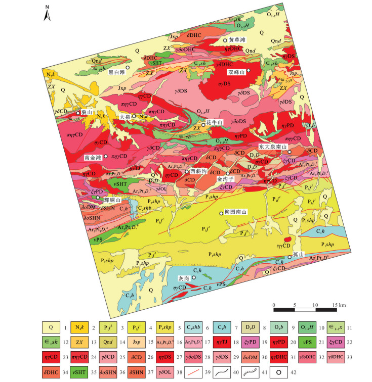
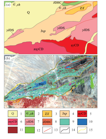
Figure 2.
Regional geological sketch map of the Huaniushan area❶
-
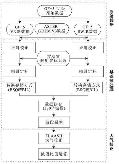
Figure 3.
Technical workflow showing preprocessing of GF-5 hyperspectral data
-
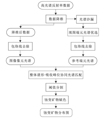
Figure 4.
Technical workflow showing mineral mapping based on GF-5 hyperspectral data
-
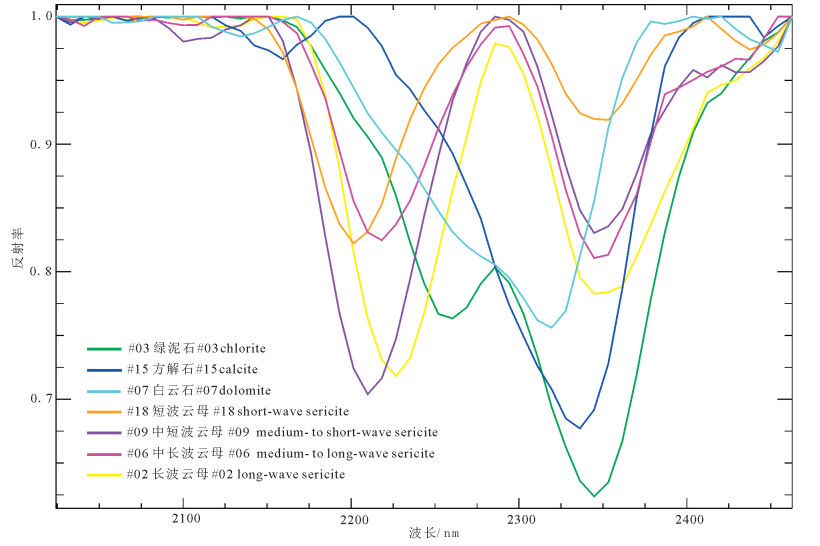
Figure 5.
Minerals endmember spectra of GF-5 SWIR data after continuum removal
-
Figure 6.
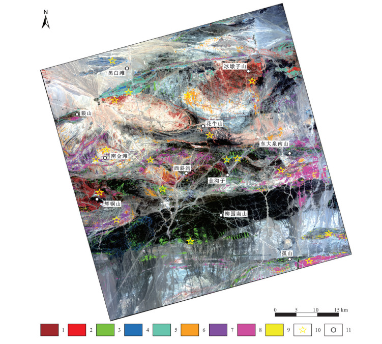
Map showing distribution of alteration minerals extracted from hyperspectral data in the Huaniushan area
-
Figure 7.
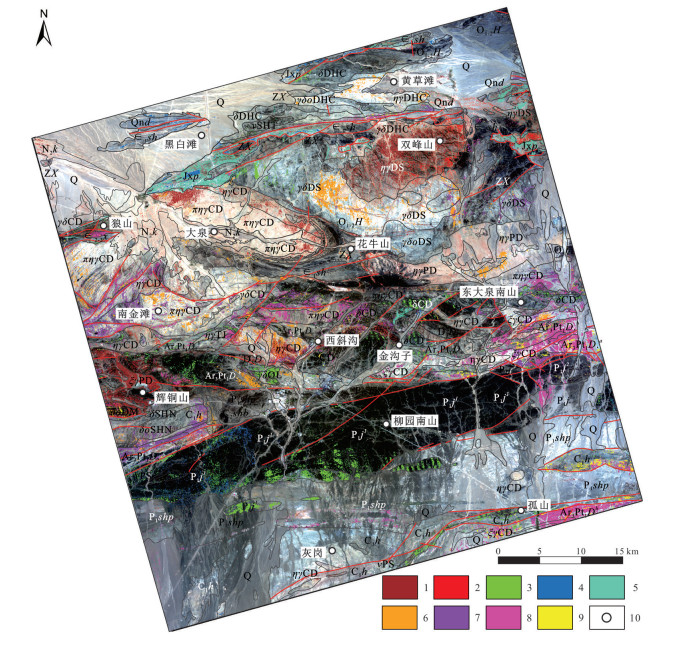
Multi-source geoscience information of lithology, structure and alteration in the Huaniushan area
-
Figure 8.
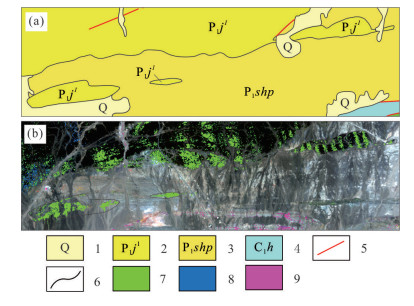
Distribution map of the chlorite alteration mineral and the lithology in Permian Jinta Formation
-
Figure 9.
Revised geological boundary of Pingtoushan Formation of Jixian System at the Heibaitan section in the Huaniushan area
-
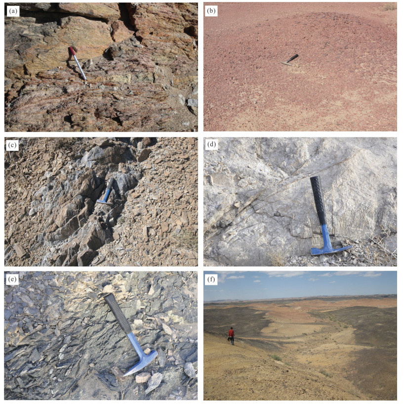
Figure 10.
Field photos of alteredrocks inthe Huaniushan area
-
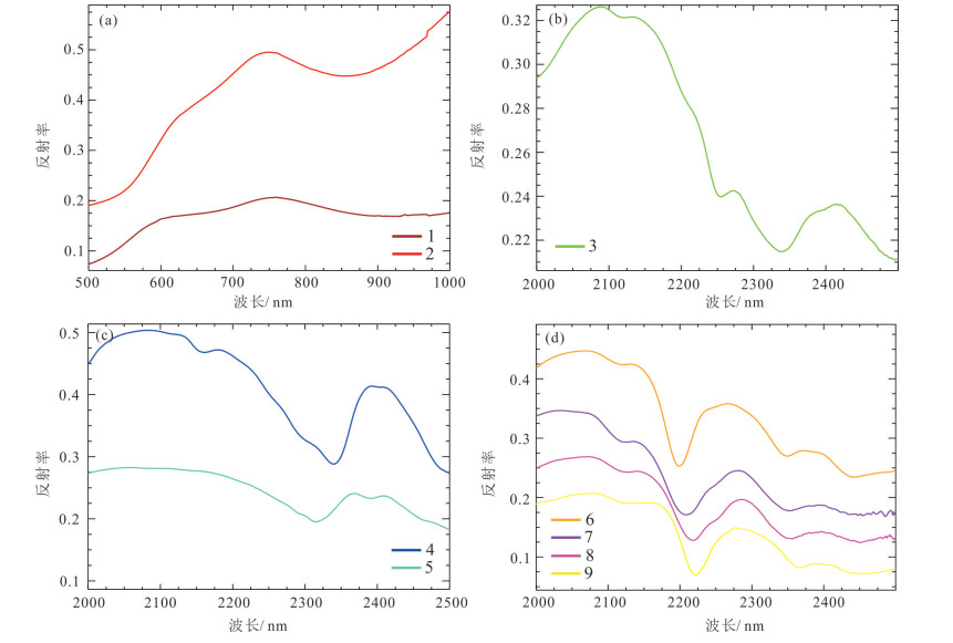
Figure 11.
Field measured spectra of alteration minerals in the Huaniushan area